
last update to page: March 31 2016 18:56:34 (UTC).
SummaryThe red marker denotes the earthquake epicenter. On Wed Mar 2nd 2016 12:49:48 (UTC) the seismic network recorded an earthquake (preliminary 7.8 mww) located in Southwest Of Sumatra, Indonesia. Seismic region Sunda Arc. The epicentral distance (i.e. distance separating the location to the epicenter) to the closest station CSLB in the network is 15,397.9 km. If you felt the quake, the USGS would like to know. Please add your comments to the USGS page "Did you feel it?". |
Details
Proximity to Population Centers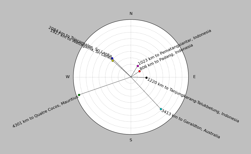
| ||||||||||||||||
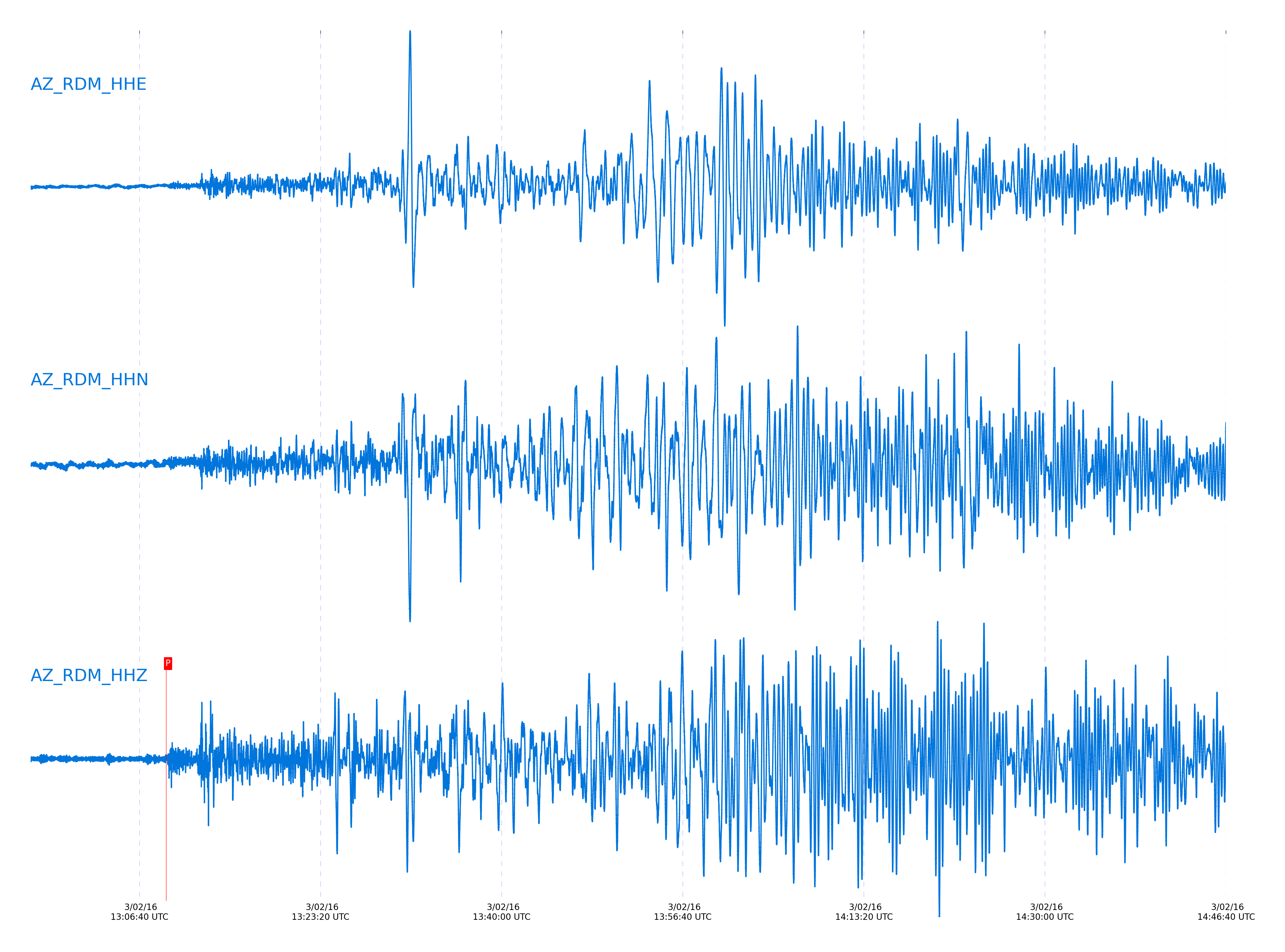
Event and active stations
|
|||||||||||||||||
Closest station with identified signal. Not filtered.
Subset of several stations close to the event. Not filtered.
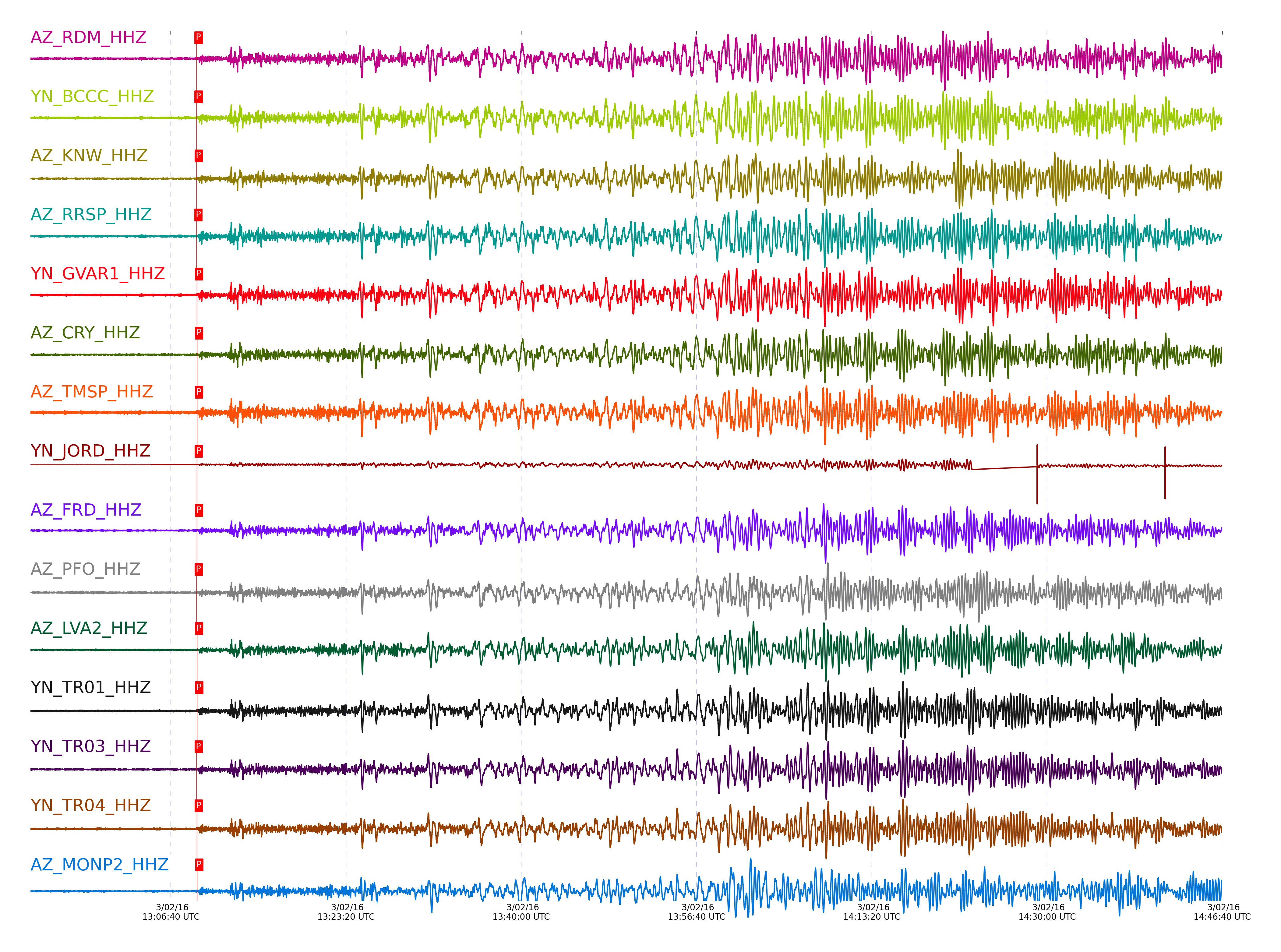
| STA_CHAN | S-E Delta | S-E Azimuth | Phase | Time | Signal/Noise | Time Residual | V. Model | Auth | arid |
|---|---|---|---|---|---|---|---|---|---|
| RDM_HHZ | 139.249° | 307.92° | PKPdf | 2016-03-02 13:09:07.2731 UTC | 23.904 | -5.493 | iasp91 | dbp:jtytell:160 | 947226 |
| BCCC_HHZ | 139.263° | 307.97° | PKPdf | 2016-03-02 13:09:06.9189 UTC | -1 | -5.873 | iasp91 | dbp:jtytell:160 | 947448 |
| KNW_HHZ | 139.286° | 308.15° | PKPdf | 2016-03-02 13:09:07.8073 UTC | 22.226 | -5.026 | iasp91 | dbp:jtytell:160 | 947227 |
| RRSP_HHZ | 139.307° | 308.06° | PKPdf | 2016-03-02 13:09:06.8523 UTC | -1 | -6.019 | iasp91 | dbp:jtytell:160 | 947447 |
| GVAR1_HHZ | 139.319° | 308.11° | PKPdf | 2016-03-02 13:09:09.4532 UTC | 15.365 | -3.44 | iasp91 | dbp:jtytell:160 | 947229 |
| CRY_HHZ | 139.361° | 307.98° | PKPdf | 2016-03-02 13:09:09.9596 UTC | -1 | -3.009 | iasp91 | dbp:jtytell:160 | 947452 |
| TMSP_HHZ | 139.365° | 308.1° | PKPdf | 2016-03-02 13:09:10.1035 UTC | -1 | -2.873 | iasp91 | dbp:jtytell:160 | 947453 |
| JORD_HHZ | 139.479° | 308° | PKPdf | 2016-03-02 13:09:08.301 UTC | -1 | -4.881 | iasp91 | dbp:jtytell:160 | 947455 |
| FRD_HHZ | 139.494° | 308.07° | PKPdf | 2016-03-02 13:09:09.6046 UTC | -1 | -3.603 | iasp91 | dbp:jtytell:160 | 947456 |
| PFO_HHZ | 139.515° | 308.35° | PKPdf | 2016-03-02 13:09:07.8628 UTC | -1 | -5.383 | iasp91 | dbp:jtytell:160 | 947459 |
| LVA2_HHZ | 139.609° | 307.99° | PKPdf | 2016-03-02 13:09:10.0399 UTC | -1 | -3.375 | iasp91 | dbp:jtytell:160 | 947468 |
| TR01_HHZ | 139.662° | 308.23° | PKPdf | 2016-03-02 13:09:10.5465 UTC | -1 | -2.964 | iasp91 | dbp:jtytell:160 | 947469 |
| TR03_HHZ | 139.664° | 308.2° | PKPdf | 2016-03-02 13:09:07.8113 UTC | -1 | -5.702 | iasp91 | dbp:jtytell:160 | 947471 |
| TR04_HHZ | 139.669° | 308.19° | PKPdf | 2016-03-02 13:09:08.2308 UTC | -1 | -5.292 | iasp91 | dbp:jtytell:160 | 947470 |
| MONP2_HHZ | 139.983° | 307.72° | PKPdf | 2016-03-02 13:09:10.9863 UTC | -1 | -3.101 | iasp91 | dbp:jtytell:160 | 947475 |
Click the link below to observe an interactive map of earthquakes recorded by the station deployment:
Broadband Seismic Data Collection Center (ANZA),
Institute of Geophysics & Planetary Physics
Scripps Institution of Oceanography,
University of California San Diego
Copyright © 1989 - 2014. All Rights Reserved.