
Earthquake frequency in the Solomon Islands
Last updated: 2018-03-26 (84) 17:50:58 UTC
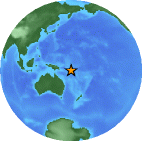
Figure 1: Location of the earthquakes relative to Australia. (© USGS)
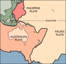
Figure 2: Regional schematic plate boundary map (© USGS)
On the 24th September 2002 there were four earthquakes in the Solomon Islands in the South Pacific (Figure 1). The size of the earthquakes ranged in magnitude from Mw 5.5 to M 6.3. There were subsequently two further events in the following week: on September 28th (magnitude 5.5) and October 1st (magnitude 5.8). Although not catastrophic, it is interesting to consider why this region consistently experiences 'medium' magnitude earthquakes.
The Solomon islands are located in a region of the world that experiences a high degree of seismicity. Positioned on the Pacific "ring of fire" (the perimeter of the Pacific plate that is subject to high levels of vulcancity), the Solomon Islands are a product of the tectonic forces in the region (Figure 2).
The Solomon Islands are located between 156° and 170° E longitude and 5° and 12° S latitude, and form a long (1200 km), thin (250 km) archipelago oriented NW - SE (Figure 3). They are positioned in the collisional zone between the Australian and Pacific plates, and consist of a complex series of crustal units. Deep ocean lies to the north-east and south-west. The islands are geologically bound by two trenches: the Vitiaz trench in the north-east, and the New Britain-San Cristobal trench in the south-west.
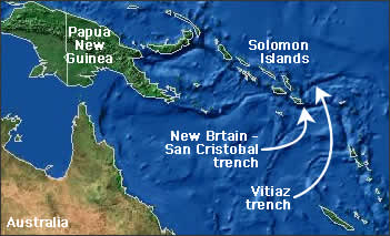
Figure 3: Regional topographic map showing the Solomon Islands, and the surrounding trenches (© National Geographic)
The Vitiaz trench is over 3000 km long, with depths up to 6000 m (6 km). The New Britain-San Cristobal trench reaches depths of up to 9000 m (9 km). Subduction (or sinking) of the Australian plate beneath the Solomon Island occurs along the New Britain-San Cristobal trench.
Below is a table with the location, time, magnitude and depth of the earthquakes that occurred on the 24th September 2002.
| Date of event | Latitude | Longitude | Size (Mw) | Depth |
|---|---|---|---|---|
| Tue Sep 24 23:01:30 2002 UTC | 10.60S | 161.17E | 6.3 | Shallow [~33km] |
| Tue Sep 24 22:54:25 2002 UTC | 10.51S | 161.00E | 6.2 | Shallow [~33km] |
| Tue Sep 24 04:13:14 2002 UTC | 10.51S | 161.14E | 6.2 | Shallow [~33km] |
| Tue Sep 24 02:26:33 2002 UTC | 10.53S | 161.13E | 5.5 | Shallow [~33km] |
All data provided by the USGS
Figure 4 is a topographic map of the region, with the location of the Tue Sep 24 02:26:33 2002 [UTC] earthquake plotted (courtesy of the USGS). Compare the location of the quakes and the map below: they all occurred east of the San Cristobal trench (the yellow line).
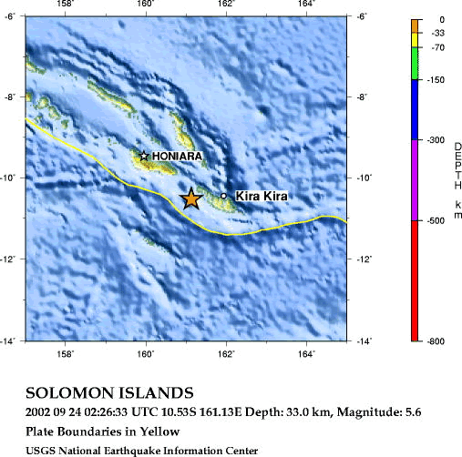
Figure 4: Bathymetric and topographic map of the Soloman Islands region, South Pacific. (© USGS)
This area is a region of high volcanic and seismic activity due to the northwards subduction of the Australian plate beneath the Solomon Islands (also known as the Solomon block): the sinking plate partially melts as it descends deeper into the Earth, releasing magma bodies that rise through the overlying Solomon block creating submarine, or underwater, volcanoes on the sea-floor (Figure 5). This type of magmatism is called island arc magmatism. Island arc magmatism is also characterised by strong seismic activity, as the subducting slab 'crunches' the overlying slab on its way down.
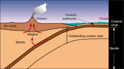
Figure 5: As the subducting slab sinks beneath the overlying plate it partially melts and releases magma. The magma rises to the surface, forming volcanoes (© Lawrence Livermore National Lab.).
The resulting earthquakes are often shallow (<100km) and of medium magnitude - just like the ones that occurred in the Solomon Islands.
References
- Auzende, Jean-Marie; Kroenke, Loren W; Collot, J Y; Lafoy, Y; Pelletier, Bernard. 1996. Compressive tectonism along the eastern margin of Malaita Island (Solomon Islands). Marine Geophysical Researches, 18, p.289-304.
- Miura, S; Shinohara, M; Takahashi, N; Araki, E; Taira, A; Suyehiro, K; Coffin, M; Shipley, T; Mann, P. 1996. OBS crustal structure of Ontong Java Plateau converging into Solomon island arc. Eos, Transactions, American Geophysical Union, 77, no.46, Suppl., p.713.
- Petterson, M G; Babbs, T; Neal, C R; Mahoney, J J; Saunders, A D; Duncan, R A; Tolia, D; Magu, R; Qopoto, C; Mahoa, H; Natogga, D. 1999. Geological-tectonic framework of Solomon Islands, SW Pacific; crustal accretion and growth within an intra-oceanic setting. Tectonophysics, 301, p.35-60.
- Phinney, Eric J; Mann, Paul; Coffin, Millard F; Shipley, Thomas H. 1999. Sequence stratigraphy, structure, and tectonic history of the southwestern Ontong Java Plateau adjacent to the North Solomon Trench and Solomon islands arc. Journal of Geophysical Research, B, Solid Earth and Planets, 104, p.20,449-20,466.
Further information
For more information on recent earthquakes in the region visit our realtime network pages, that are updated automatically every 30 minutes.
Images courtesy of the Lawrence Livermore National Laboratory, the United States Geological Survey and National Geographic Online. More information on these events may be available at the IRIS or TRINET websites.
Learn more about the Anza group (including who works
here, other networks, nuclear tests in China/India/Pakistan).
Learn
more about the ANZA network
(includes more station information, research, etc).