
Magnitude 5.2 quake near Napa
Last updated: 2018-03-26 17:50:58 UTC
![Vertical components [all Anza stations]](vert.gif)
The Anza group at the University of California San Diego operates a broadband seismograph network consisting of 13 (+ 2) three component broadband seismograph stations centered near Anza Californa (see map).
If you did feel the quake, USGS would like to know. Add to the USGS "Did you feel it?" page.
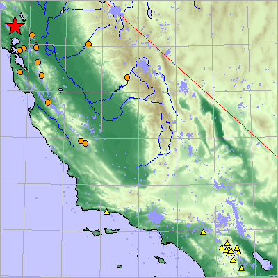
On Sunday September 3rd, 2000 shortly after 01:36 PDT we recorded a quake (preliminary ml 5.2) located approximately 14 km to the NW of the town of Napa.
The epicentral distance (distance separating the epicenter and the recording network) is ~6.77 degrees (752km). This quake is considered to be a "regional" event based on the epicentral distance.
View the most recent local map of events or the full bulletin of all events recorded by the Anza network
The closest Anza station to this event, RDM is approximately 727 km SE of the source. The Northern California Earthquake Center operates numerous seismic stations in Northern California and may have additional information from stations that were closer to the epicenter.
This map shows the mainshock (red star). NCEC stations are orange circles. Anza network stations are yellow triangles. Backgound seismicity is plotted in light blue dots. Mapped faults are thin red lines.
Initial source parameters:
Latitude |
Longitude |
Depth |
Origin Time (UTC) |
ml |
Author |
| 38.380 | -122.410 | 9.4 | 9/03/2000 (247) 08:36:00 | 5.2 | QED |
You may also view a plot showing the:
An external
site (IRIS-DMC)
also has a page with more information about this event.
Read a brief description of the geology of the area.
Learn more about the Anza group (including who works here, station information, research, other networks, nuclear tests in China/ India/ Pakistan).
If you are interested in retrieving data for this event, please visit the IRIS-DMC for data access.
URL: http://eqinfo.ucsd.edu/special_events/2000/247/a/index.php [Last updated: 2018-03-26 17:50:58 UTC]