
Magnitude 6.5 quake near Bam, Southern Iran
Last updated: 2018-03-26 17:50:56 UTC
Quick Links
- Location map
- Initial source parameters
- 3 components [closest KNET station]
- Vertical components [all Anza stations]
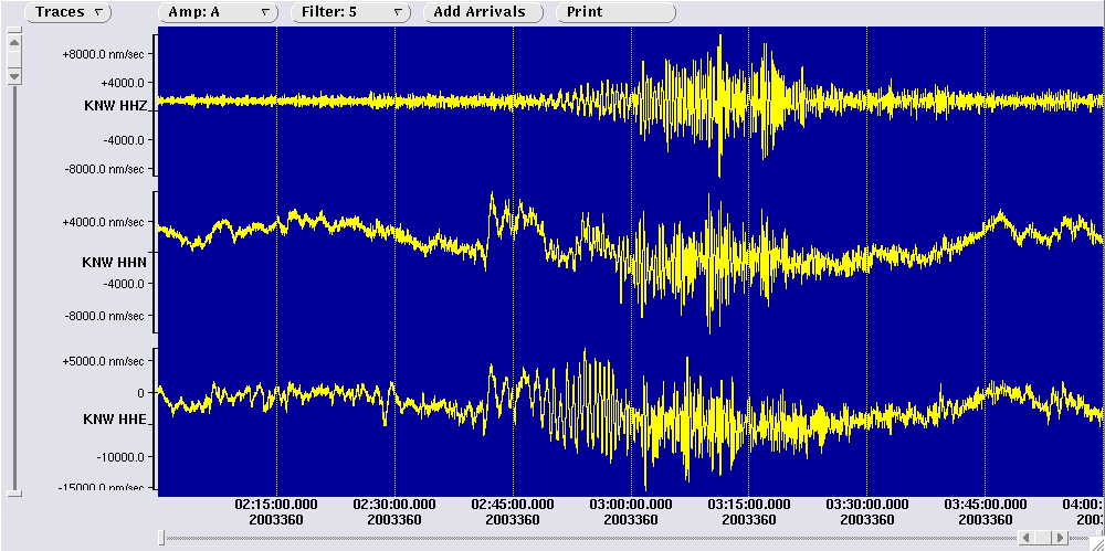
- Vertical components [KNET stations]
- Vertical components [all Anza stations]
- Waveforms recorded at Mt. Soledad
![3 components [closest KNET station]](3comp_vert_KNET.gif)
![Vertical components [all Anza stations]](Anza_verts.gif)
![Vertical components [KNET stations]](Knet_verts.gif)
Translations
![]()
![]()
![]()
![]()
![]()
![]()
![]()
![]()
![]()
The Anza group at the University of California San Diego operates a broadband seismograph network consisting of 17 three component broadband seismograph stations centered near Anza, California (see map).
On Thursday, December 25th, 2003 at 5:56 PM (PST) we recorded a quake (preliminary mb 6.5) located near the city of Bam, Southern Iran. Local reports suggest that thousands have been killed, with estimates ranging from 4,000 to 20,000. The injured number varies from 30,000 to 50,000. A pictorial essay has been compiled by Iranmania.com and can be viewed by clicking here.
View the most recent map of local events near San Diego or a slightly wider regional view of events recoded by ANZA, or a map of events recoded by ANZA from around the globe.
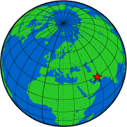
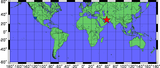
Initial source parameters for the recent event are shown below. The epicentral distance (distance separating the epicenter and the closest station in the recording network) for Anza is 13086 km (117.658 degrees).
This map shows the mainshock (red star) and any associated aftershocks (orange stars). Anza network stations are blue triangles.
| Latitude | Longitude | Origin time (UTC) | Origin time (PST) | Depth (km) | mb | Author |
| 28.99 | 58.29 | 12/26/03 (360) 01:56:52 | 12/25/03 (359) 17:56:52 | 10 | 6.5* | USGS |
* The location and magnitude determined for this event are preliminary and are subject to change upon further review of seismic data.
The ANZA broadband network is located in the 'shadow zone' with respect to this earthquake and as a result there is an absence of P-wave energy in the associated seismic waveforms (see below). Find out what the 'shadow zone' is and why it is important in seismic studies: SHADOW ZONE.
We also collect data from the KNET network, located in the Republic of Kyrgyzstan, which is much closer to the epicenter of this event and not in the shadow zone. You can click on the links below and see the waveforms from both the Anza and KNET networks. It is interesting to compare the waveforms recorded from each network and see the effect of the shadow zone.
- the 3 components recorded by the closest Anza station
- the 3 components recorded by the closest KNET station
- the vertical components for all Anza stations
- the vertical components for all KNET stations
Of local interest:
We operate a broadband station on Mt. Soledad.
At 18:15 (PST) station SOL recorded the S wave from this event.
Here is a view of that event as picked by our analyst. A pink "P" indicates a P wave arrival,
a pink "S" indicates an S wave arrival.
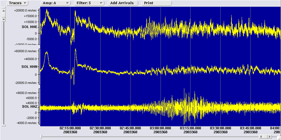
View a larger image showing the waveforms recorded at Mt. Soledad.
Visit the USGS website with additional links to seismic data for this event.
News Links
To search the internet for more information about this event, click on the button below:
![]()
Learn more about the Anza group (including who works here, other networks, nuclear tests in China/India/Pakistan).
Learn more about the ANZA network (includes more station information, research, etc).
URL: http://eqinfo.ucsd.edu/special_events/2003/360/a/index.php [Last updated: 2018-03-26 17:50:56 UTC]