
last update to page: May 12 2016 19:30:40 (UTC).
SummaryThe red marker denotes the earthquake epicenter. On Wed May 11th 2016 09:03:11 (UTC) the seismic network recorded an earthquake (preliminary 4.4 mwr) located in Baja California, Mexico. Seismic region Baja California And Gulf Of California. The epicentral distance (i.e. distance separating the location to the epicenter) to the closest station MONP2 in the network is 236.9 km. If you felt the quake, the USGS would like to know. Please add your comments to the USGS page "Did you feel it?". |
Details
Proximity to Population Centers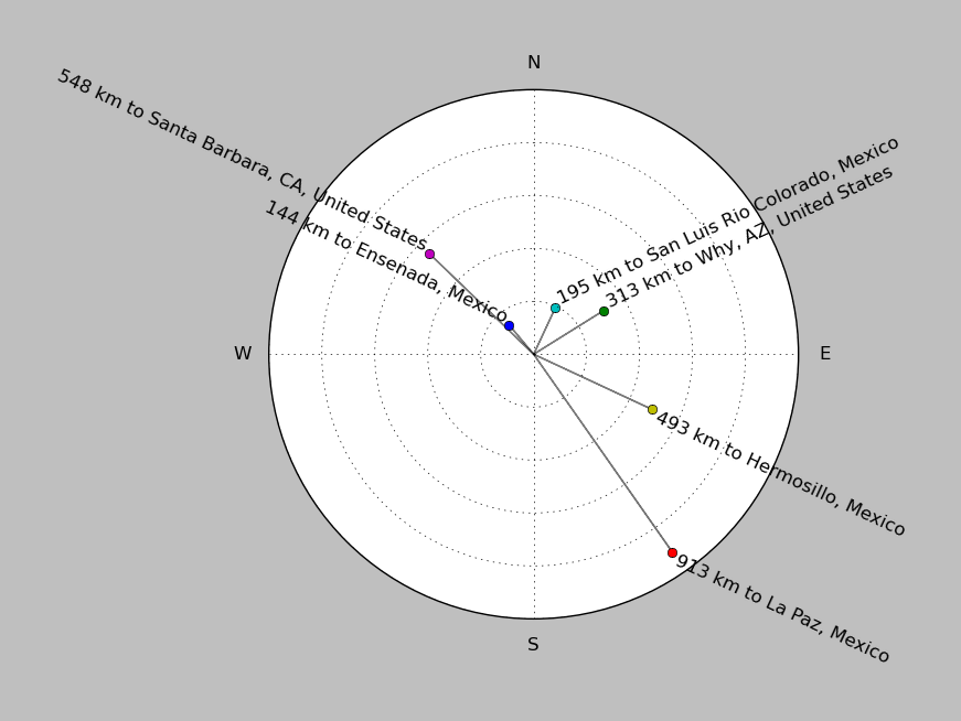
| ||||||||||||||||
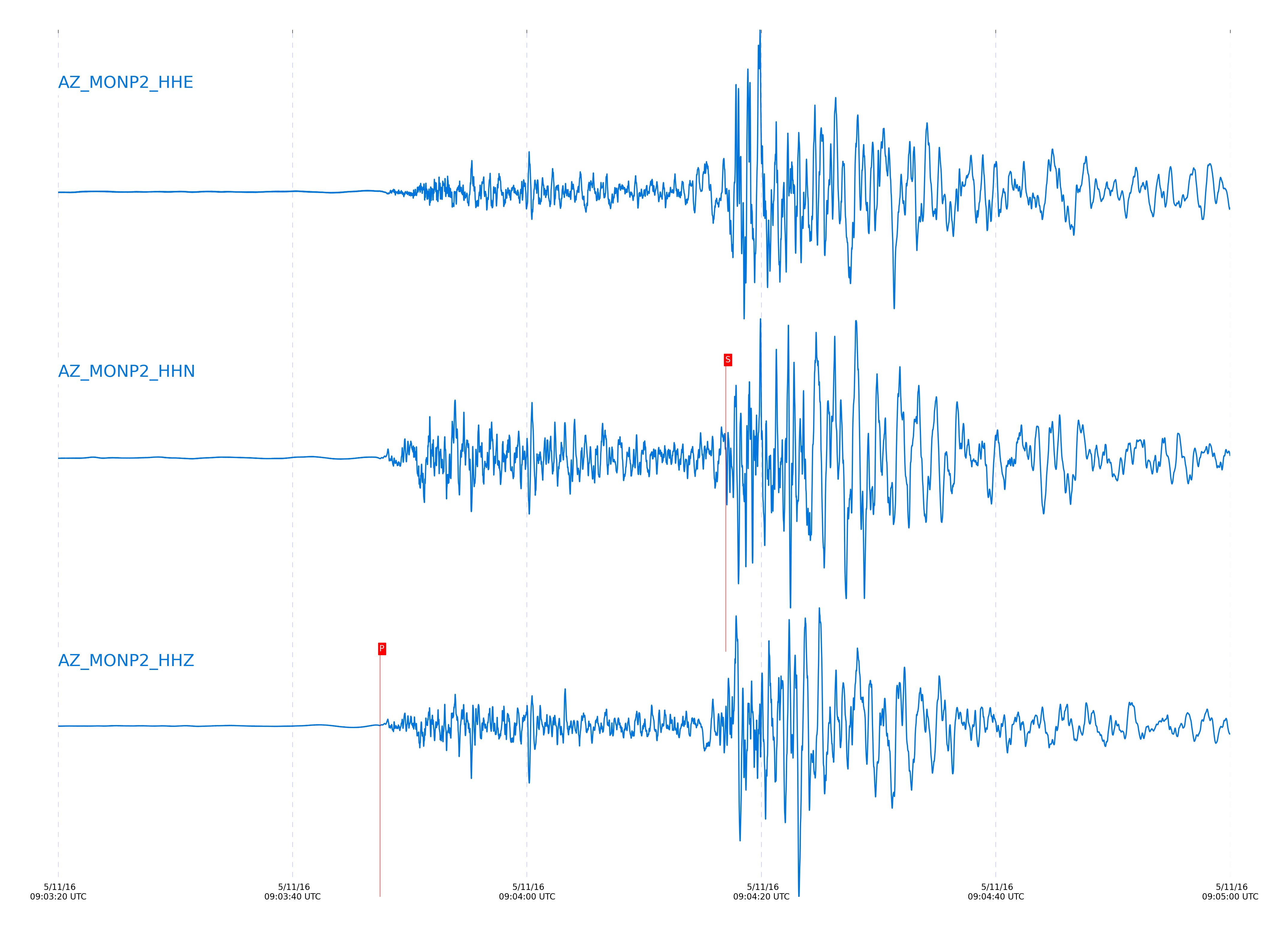
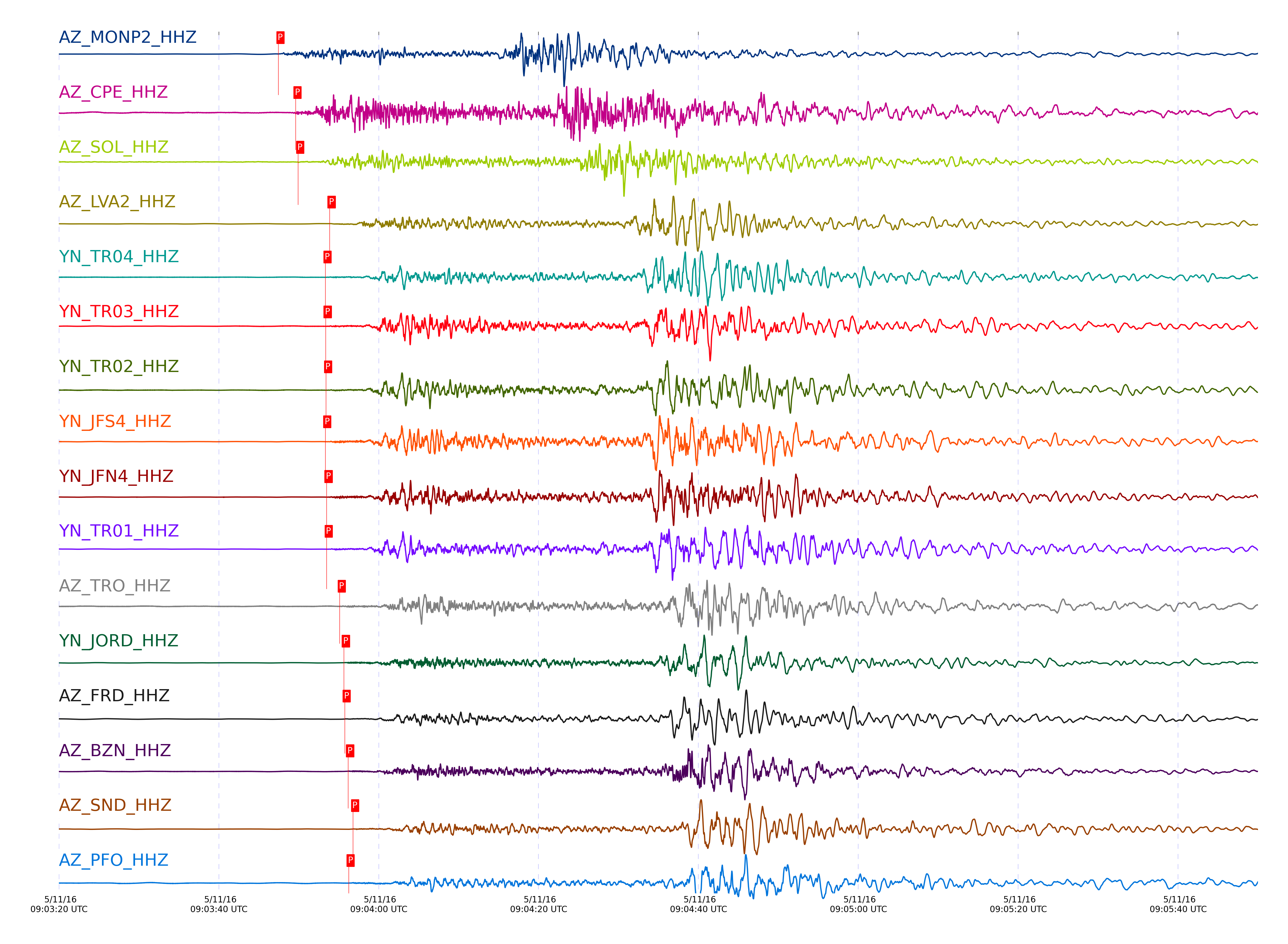
Event and active stations
|
|||||||||||||||||
Closest station with identified signal. Not filtered.
Subset of several stations close to the event. Not filtered.
| STA_CHAN | S-E Delta | S-E Azimuth | Phase | Time | Signal/Noise | Time Residual | V. Model | Auth | arid |
|---|---|---|---|---|---|---|---|---|---|
| MONP2_HHZ | 2.128° | 161.83° | Pn | 2016-05-11 09:03:47.4645 UTC | 82.851 | 0.394 | iasp91 | dbp:jtytell:161 | 1007691 |
| MONP2_HHN | 2.128° | 161.83° | Sb | 2016-05-11 09:04:16.9678 UTC | -1 | -1.406 | iasp91 | dbp:jtytell:161 | 1008775 |
| CPE_HHZ | 2.369° | 148.16° | Pn | 2016-05-11 09:03:49.6029 UTC | 24.777 | -0.785 | iasp91 | dbp:jtytell:161 | 1007774 |
| CPE_HHN | 2.369° | 148.16° | Sn | 2016-05-11 09:04:22.1734 UTC | -1 | 1.795 | iasp91 | dbp:jtytell:161 | 1008780 |
| SOL_HHZ | 2.396° | 145.04° | Pn | 2016-05-11 09:03:49.932 UTC | 14.969 | -0.815 | iasp91 | dbp:jtytell:161 | 1007694 |
| SOL_HHE | 2.396° | 145.04° | Sb | 2016-05-11 09:04:24.9683 UTC | -1 | -1.305 | iasp91 | dbp:jtytell:161 | 1008781 |
| LVA2_HHZ | 2.602° | 162.47° | Pn | 2016-05-11 09:03:53.8627 UTC | 47.595 | 0.284 | iasp91 | dbp:jtytell:161 | 1007693 |
| LVA2_HHE | 2.602° | 162.47° | Sb | 2016-05-11 09:04:32.5907 UTC | -1 | 0.231 | iasp91 | dbp:jtytell:161 | 1008784 |
| TR04_HHZ | 2.615° | 165.22° | Pn | 2016-05-11 09:03:53.3408 UTC | -1 | -0.429 | iasp91 | dbp:jtytell:161 | 1008747 |
| TR04_HHE | 2.615° | 165.22° | Sb | 2016-05-11 09:04:33.2466 UTC | -1 | 0.477 | iasp91 | dbp:jtytell:161 | 1008785 |
| TR03_HHZ | 2.625° | 165.33° | Pn | 2016-05-11 09:03:53.3763 UTC | -1 | -0.528 | iasp91 | dbp:jtytell:161 | 1008748 |
| TR03_HHN | 2.625° | 165.33° | Sb | 2016-05-11 09:04:33.1074 UTC | -1 | 0.049 | iasp91 | dbp:jtytell:161 | 1008786 |
| TR02_HHZ | 2.632° | 165.5° | Pn | 2016-05-11 09:03:53.4251 UTC | -1 | -0.577 | iasp91 | dbp:jtytell:161 | 1008749 |
| TR02_HHE | 2.632° | 165.5° | Sb | 2016-05-11 09:04:33.6163 UTC | -1 | 0.346 | iasp91 | dbp:jtytell:161 | 1008788 |
| JFS4_HHZ | 2.633° | 165.76° | Pn | 2016-05-11 09:03:53.3223 UTC | -1 | -0.696 | iasp91 | dbp:jtytell:161 | 1008750 |
| JFS4_HHN | 2.633° | 165.76° | Sb | 2016-05-11 09:04:33.6873 UTC | -1 | 0.382 | iasp91 | dbp:jtytell:161 | 1008789 |
| JFN4_HHZ | 2.635° | 165.82° | Pn | 2016-05-11 09:03:53.4891 UTC | -1 | -0.552 | iasp91 | dbp:jtytell:161 | 1008751 |
| JFN4_HHE | 2.635° | 165.82° | Sb | 2016-05-11 09:04:33.9014 UTC | -1 | 0.548 | iasp91 | dbp:jtytell:161 | 1008790 |
| TR01_HHZ | 2.636° | 165.58° | Pn | 2016-05-11 09:03:53.5021 UTC | 52.889 | -0.552 | iasp91 | dbp:jtytell:161 | 1007692 |
| TR01_HHE | 2.636° | 165.58° | Sb | 2016-05-11 09:04:33.9418 UTC | -1 | 0.56 | iasp91 | dbp:jtytell:161 | 1008791 |
| TRO_HHZ | 2.736° | 165.89° | Pn | 2016-05-11 09:03:55.1242 UTC | 8.0636 | -0.304 | iasp91 | dbp:jtytell:161 | 1007699 |
| TRO_HHE | 2.736° | 165.89° | Sb | 2016-05-11 09:04:35.9453 UTC | -1 | -0.389 | iasp91 | dbp:jtytell:161 | 1008795 |
| JORD_HHZ | 2.738° | 161.8° | Pn | 2016-05-11 09:03:55.6496 UTC | 46.671 | 0.198 | iasp91 | dbp:jtytell:161 | 1007700 |
| JORD_HHN | 2.738° | 161.8° | Sb | 2016-05-11 09:04:35.8318 UTC | -1 | -0.552 | iasp91 | dbp:jtytell:161 | 1008798 |
| FRD_HHZ | 2.748° | 162.68° | Pn | 2016-05-11 09:03:55.7483 UTC | 14.643 | 0.152 | iasp91 | dbp:jtytell:161 | 1007698 |
| FRD_HHE | 2.748° | 162.68° | Sb | 2016-05-11 09:04:36.4968 UTC | -1 | -0.199 | iasp91 | dbp:jtytell:161 | 1008799 |
| BZN_HHZ | 2.762° | 161.55° | Pn | 2016-05-11 09:03:56.1828 UTC | 9.5349 | 0.4 | iasp91 | dbp:jtytell:161 | 1007701 |
| BZN_HHN | 2.762° | 161.55° | Sb | 2016-05-11 09:04:36.6284 UTC | -1 | -0.468 | iasp91 | dbp:jtytell:161 | 1008803 |
| SND_HHZ | 2.805° | 162.84° | Pn | 2016-05-11 09:03:56.7955 UTC | 40.16 | 0.412 | iasp91 | dbp:jtytell:161 | 1007714 |
| SND_HHE | 2.805° | 162.84° | Sb | 2016-05-11 09:04:38.7078 UTC | -1 | 0.319 | iasp91 | dbp:jtytell:161 | 1008806 |
| PFO_HHZ | 2.828° | 165.76° | Pn | 2016-05-11 09:03:56.246 UTC | 13.347 | -0.454 | iasp91 | dbp:jtytell:161 | 1007713 |
| PFO_HHE | 2.828° | 165.76° | Sb | 2016-05-11 09:04:38.4762 UTC | -1 | -0.591 | iasp91 | dbp:jtytell:161 | 1008813 |
| WMC_HHZ | 2.842° | 161.95° | Pb | 2016-05-11 09:04:01.7115 UTC | 129.65 | -0.573 | iasp91 | dbp:jtytell:161 | 1007749 |
| WMC_HHE | 2.842° | 161.95° | Sb | 2016-05-11 09:04:39.3706 UTC | -1 | -0.089 | iasp91 | dbp:jtytell:161 | 1008816 |
| CRY_HHE | 2.851° | 160.87° | Sb | 2016-05-11 09:04:38.7381 UTC | -1 | -0.984 | iasp91 | dbp:jtytell:161 | 1008817 |
| TMSP_HHZ | 2.887° | 162.13° | Pn | 2016-05-11 09:03:57.8357 UTC | -1 | 0.335 | iasp91 | dbp:jtytell:161 | 1008762 |
| TMSP_HHE | 2.887° | 162.13° | Sb | 2016-05-11 09:04:41.4098 UTC | -1 | 0.621 | iasp91 | dbp:jtytell:161 | 1008818 |
| SMER_HHZ | 2.893° | 153.15° | Pn | 2016-05-11 09:03:57.7004 UTC | 38.624 | 0.117 | iasp91 | dbp:jtytell:161 | 1007735 |
| SMER_HHE | 2.893° | 153.15° | Sb | 2016-05-11 09:04:37.9969 UTC | -1 | -2.97 | iasp91 | dbp:jtytell:161 | 1008819 |
| RRSP_HHZ | 2.933° | 161.38° | Pn | 2016-05-11 09:03:58.7165 UTC | -1 | 0.584 | iasp91 | dbp:jtytell:161 | 1008763 |
| RRSP_HHN | 2.933° | 161.38° | Sb | 2016-05-11 09:04:42.4686 UTC | -1 | 0.322 | iasp91 | dbp:jtytell:161 | 1008821 |
| GVAR1_HHZ | 2.938° | 162° | Pn | 2016-05-11 09:03:58.5036 UTC | 14.252 | 0.296 | iasp91 | dbp:jtytell:161 | 1007715 |
| GVAR1_HHE | 2.938° | 162° | Sb | 2016-05-11 09:04:42.1166 UTC | -1 | -0.191 | iasp91 | dbp:jtytell:161 | 1008822 |
| RDM_HHE | 2.943° | 159.53° | Sb | 2016-05-11 09:04:40.8185 UTC | -1 | -1.621 | iasp91 | dbp:jtytell:161 | 1008823 |
| BCCC_HHZ | 2.948° | 160.22° | Pn | 2016-05-11 09:03:58.8624 UTC | 9.6243 | 0.521 | iasp91 | dbp:jtytell:161 | 1007723 |
| BCCC_HHE | 2.948° | 160.22° | Sb | 2016-05-11 09:04:40.541 UTC | -1 | -2.054 | iasp91 | dbp:jtytell:161 | 1008824 |
| RHIL_HHZ | 2.962° | 161.01° | Pn | 2016-05-11 09:03:59.2102 UTC | -1 | 0.678 | iasp91 | dbp:jtytell:161 | 1008764 |
| RHIL_HHE | 2.962° | 161.01° | Sb | 2016-05-11 09:04:42.7134 UTC | -1 | -0.293 | iasp91 | dbp:jtytell:161 | 1008825 |
| KNW_HHZ | 2.985° | 162.2° | Pn | 2016-05-11 09:03:58.9062 UTC | 20.751 | 0.055 | iasp91 | dbp:jtytell:161 | 1007716 |
| KNW_HHE | 2.985° | 162.2° | Sb | 2016-05-11 09:04:43.1103 UTC | -1 | -0.582 | iasp91 | dbp:jtytell:161 | 1008828 |
Click the link below to observe an interactive map of earthquakes recorded by the station deployment:
Broadband Seismic Data Collection Center (ANZA),
Institute of Geophysics & Planetary Physics
Scripps Institution of Oceanography,
University of California San Diego
Copyright © 1989 - 2014. All Rights Reserved.