
last update to page: May 18 2016 20:43:40 (UTC).
SummaryThe red marker denotes the earthquake epicenter. On Wed May 18th 2016 16:46:44 (UTC) the seismic network recorded an earthquake (preliminary 6.8 mww) located in Near Coast Of Ecuador. Seismic region Andean South America. The epicentral distance (i.e. distance separating the location to the epicenter) to the closest station USGCB in the network is 5,259.7 km. If you felt the quake, the USGS would like to know. Please add your comments to the USGS page "Did you feel it?". |
Details
Proximity to Population Centers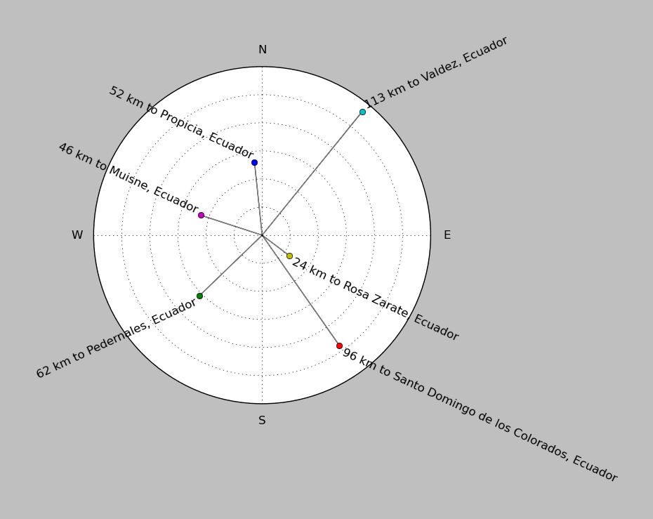
| ||||||||||||||||
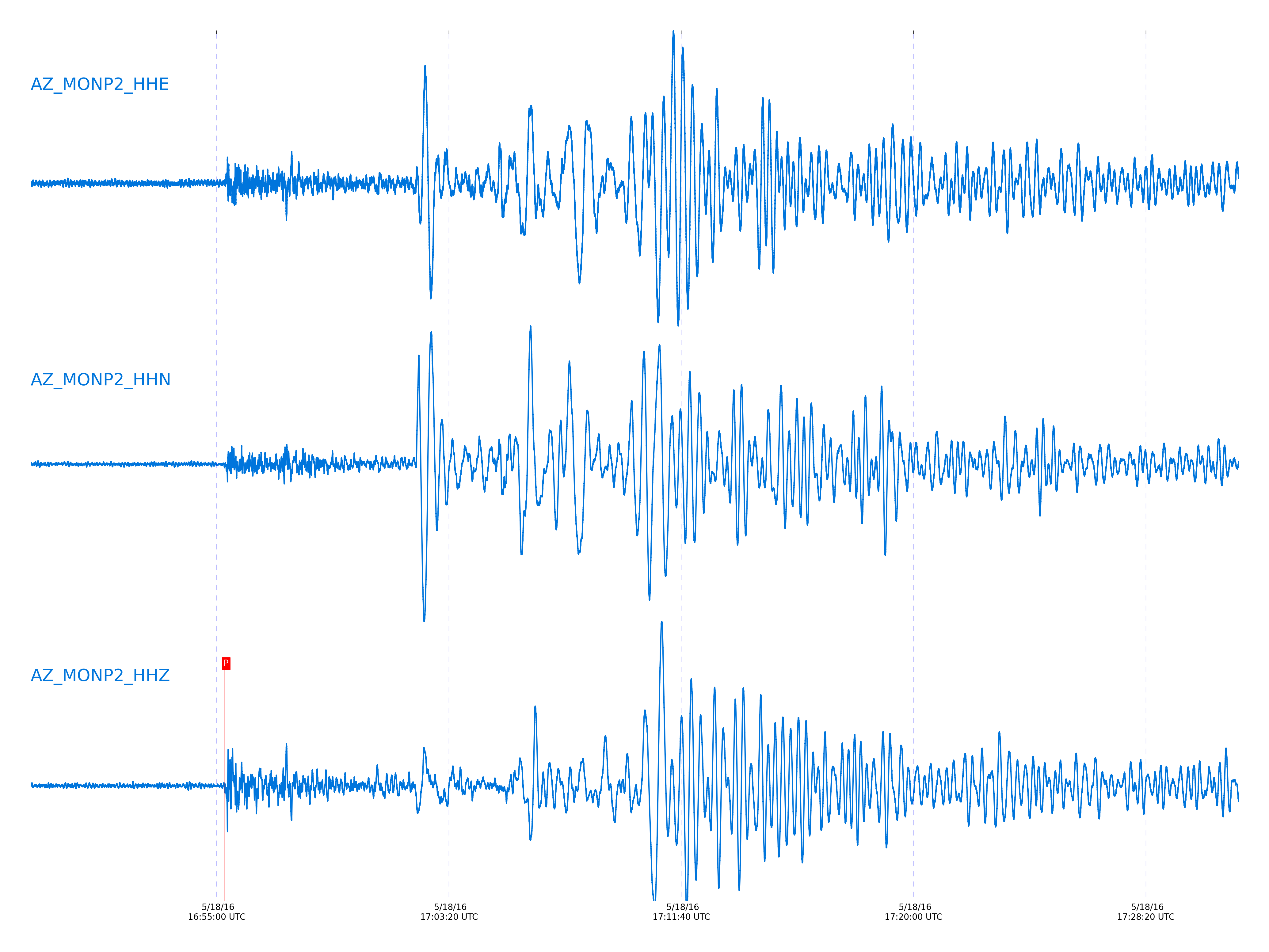
Event and active stations
|
|||||||||||||||||
Closest station with identified signal. Not filtered.
Subset of several stations close to the event. Not filtered.
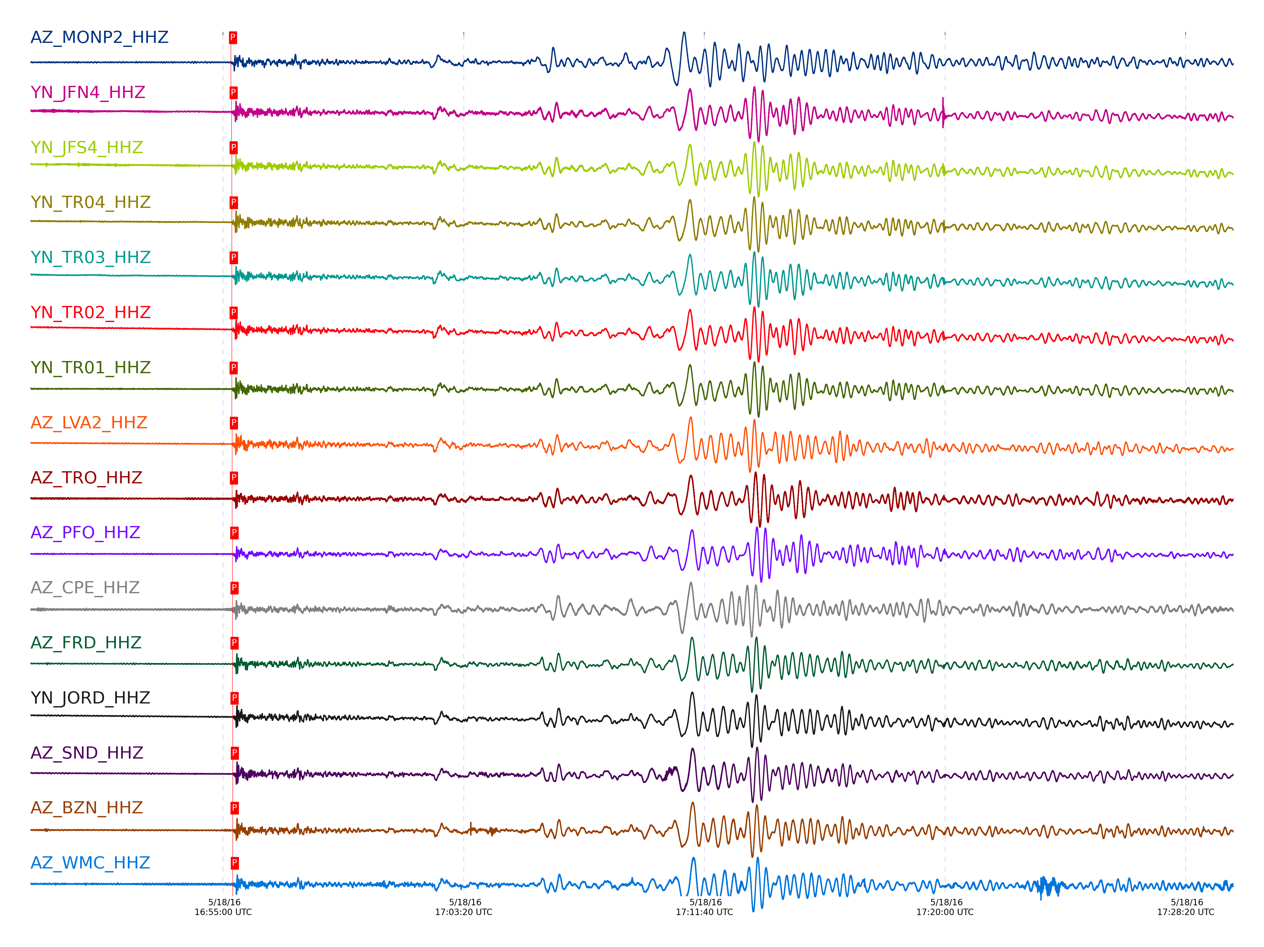
| STA_CHAN | S-E Delta | S-E Azimuth | Phase | Time | Signal/Noise | Time Residual | V. Model | Auth | arid |
|---|---|---|---|---|---|---|---|---|---|
| MONP2_HHZ | 47.397° | 125.57° | P | 2016-05-18 16:55:16.2936 UTC | 53.047 | 0.999 | iasp91 | dbp:jtytell:161 | 1012605 |
| JFN4_HHZ | 47.694° | 125.98° | P | 2016-05-18 16:55:17.8148 UTC | -1 | 0.213 | iasp91 | dbp:jtytell:161 | 1012730 |
| JFS4_HHZ | 47.694° | 125.98° | P | 2016-05-18 16:55:17.8955 UTC | -1 | 0.289 | iasp91 | dbp:jtytell:161 | 1012731 |
| TR04_HHZ | 47.695° | 125.94° | P | 2016-05-18 16:55:18.1074 UTC | -1 | 0.492 | iasp91 | dbp:jtytell:161 | 1012732 |
| TR03_HHZ | 47.7° | 125.95° | P | 2016-05-18 16:55:18.0407 UTC | -1 | 0.391 | iasp91 | dbp:jtytell:161 | 1012733 |
| TR02_HHZ | 47.701° | 125.96° | P | 2016-05-18 16:55:17.9707 UTC | -1 | 0.315 | iasp91 | dbp:jtytell:161 | 1012734 |
| TR01_HHZ | 47.701° | 125.97° | P | 2016-05-18 16:55:17.9997 UTC | 99.041 | 0.34 | iasp91 | dbp:jtytell:161 | 1012542 |
| LVA2_HHZ | 47.759° | 125.77° | P | 2016-05-18 16:55:18.4778 UTC | 102.21 | 0.365 | iasp91 | dbp:jtytell:161 | 1012535 |
| TRO_HHZ | 47.768° | 126.03° | P | 2016-05-18 16:55:18.6484 UTC | 130.13 | 0.467 | iasp91 | dbp:jtytell:161 | 1012540 |
| PFO_HHZ | 47.843° | 126.06° | P | 2016-05-18 16:55:19.4044 UTC | 100.24 | 0.644 | iasp91 | dbp:jtytell:161 | 1012537 |
| CPE_HHZ | 47.863° | 124.89° | P | 2016-05-18 16:55:19.7135 UTC | 72.347 | 0.796 | iasp91 | dbp:jtytell:161 | 1012606 |
| FRD_HHZ | 47.871° | 125.83° | P | 2016-05-18 16:55:19.6441 UTC | 97.002 | 0.669 | iasp91 | dbp:jtytell:161 | 1012545 |
| JORD_HHZ | 47.887° | 125.77° | P | 2016-05-18 16:55:19.817 UTC | 128.37 | 0.72 | iasp91 | dbp:jtytell:161 | 1012547 |
| SND_HHZ | 47.911° | 125.86° | P | 2016-05-18 16:55:20.0862 UTC | 59.363 | 0.796 | iasp91 | dbp:jtytell:161 | 1012548 |
| BZN_HHZ | 47.913° | 125.77° | P | 2016-05-18 16:55:19.9184 UTC | 103.71 | 0.619 | iasp91 | dbp:jtytell:161 | 1012544 |
| WMC_HHZ | 47.966° | 125.82° | P | 2016-05-18 16:55:20.3131 UTC | 86.107 | 0.601 | iasp91 | dbp:jtytell:161 | 1012550 |
| TMSP_HHZ | 47.997° | 125.85° | P | 2016-05-18 16:55:20.443 UTC | -1 | 0.492 | iasp91 | dbp:jtytell:161 | 1012746 |
| CRY_HHZ | 48.003° | 125.75° | P | 2016-05-18 16:55:20.3579 UTC | 114.34 | 0.356 | iasp91 | dbp:jtytell:161 | 1012549 |
| GVAR1_HHZ | 48.042° | 125.86° | P | 2016-05-18 16:55:20.5178 UTC | 103.68 | 0.219 | iasp91 | dbp:jtytell:161 | 1012538 |
| RRSP_HHZ | 48.055° | 125.81° | P | 2016-05-18 16:55:20.8947 UTC | -1 | 0.492 | iasp91 | dbp:jtytell:161 | 1012748 |
| KNW_HHZ | 48.073° | 125.88° | P | 2016-05-18 16:55:20.8166 UTC | -1 | 0.274 | iasp91 | dbp:jtytell:161 | 1012749 |
| RHIL_HHZ | 48.089° | 125.8° | P | 2016-05-18 16:55:21.1866 UTC | -1 | 0.519 | iasp91 | dbp:jtytell:161 | 1012751 |
| BCCC_HHZ | 48.101° | 125.74° | P | 2016-05-18 16:55:21.219 UTC | 140.55 | 0.465 | iasp91 | dbp:jtytell:161 | 1012553 |
| RDM_HHZ | 48.116° | 125.69° | P | 2016-05-18 16:55:21.2821 UTC | 148.83 | 0.41 | iasp91 | dbp:jtytell:161 | 1012551 |
| SMER_HHZ | 48.235° | 125.24° | P | 2016-05-18 16:55:22.1762 UTC | 74.781 | 0.383 | iasp91 | dbp:jtytell:161 | 1012552 |
Click the link below to observe an interactive map of earthquakes recorded by the station deployment:
Broadband Seismic Data Collection Center (ANZA),
Institute of Geophysics & Planetary Physics
Scripps Institution of Oceanography,
University of California San Diego
Copyright © 1989 - 2014. All Rights Reserved.