
last update to page: May 31 2016 19:17:08 (UTC).
SummaryThe red marker denotes the earthquake epicenter. On Sat May 28th 2016 09:46:59 (UTC) the seismic network recorded an earthquake (preliminary 7.2 mww) located in South Sandwich Islands Region. Seismic region Southern Antilles. The epicentral distance (i.e. distance separating the location to the epicenter) to the closest station USGCB in the network is 12,970.2 km. If you felt the quake, the USGS would like to know. Please add your comments to the USGS page "Did you feel it?". |
Details
Proximity to Population Centers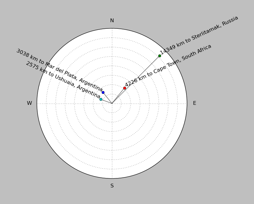
| ||||||||||||||||
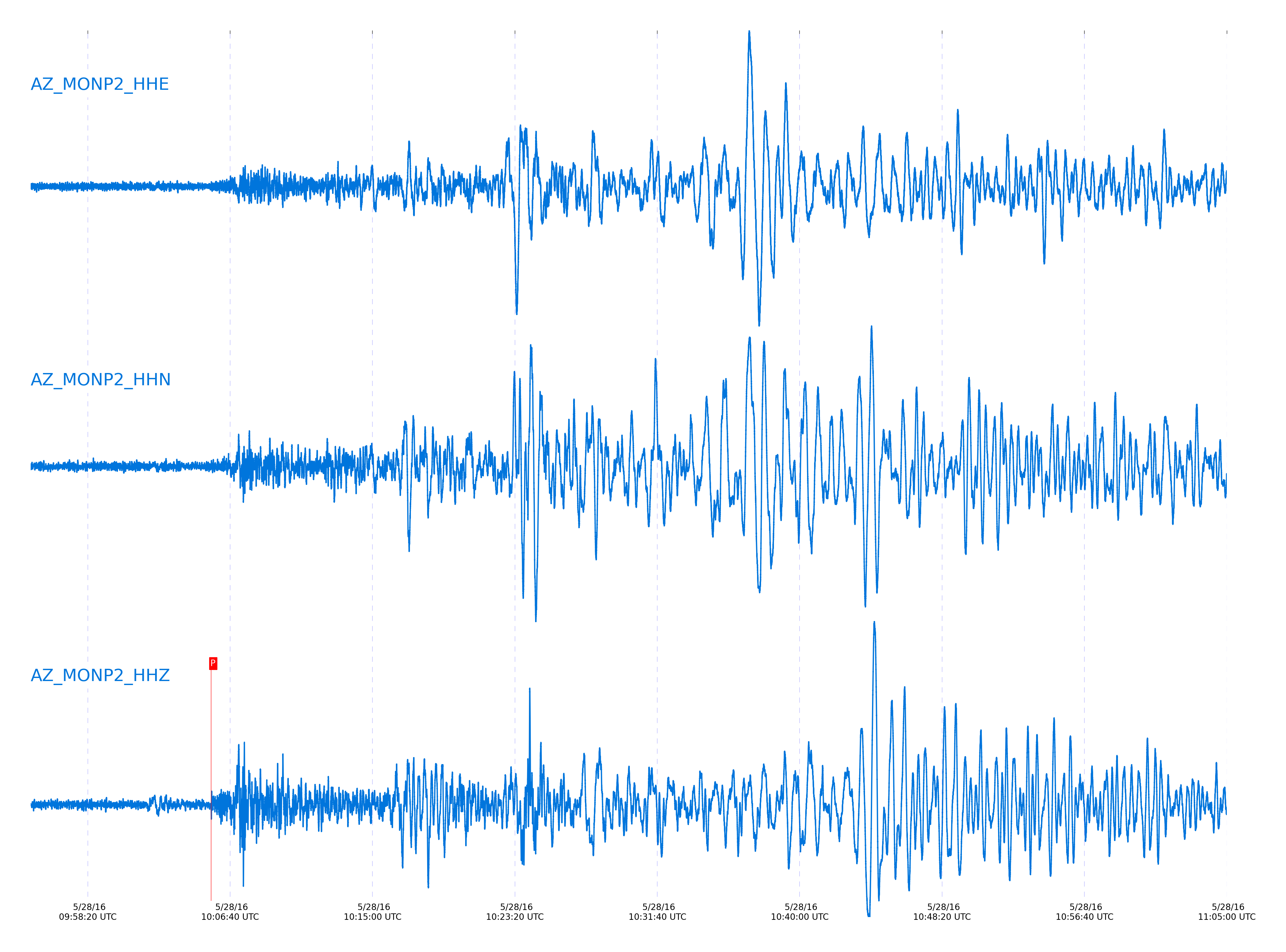
Event and active stations
|
|||||||||||||||||
Closest station with identified signal. Not filtered.
Subset of several stations close to the event. Not filtered.
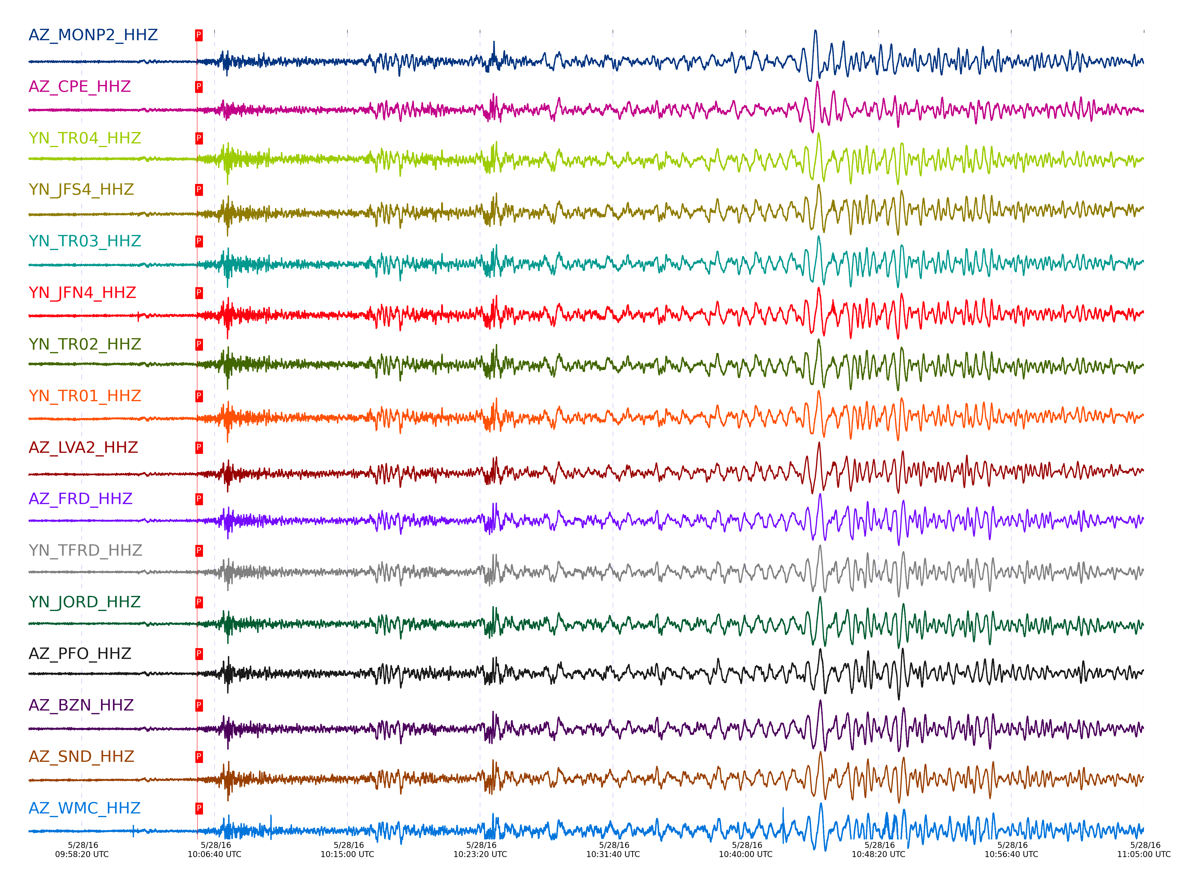
| STA_CHAN | S-E Delta | S-E Azimuth | Phase | Time | Signal/Noise | Time Residual | V. Model | Auth | arid |
|---|---|---|---|---|---|---|---|---|---|
| MONP2_HHZ | 116.581° | 141.54° | PKPdf | 2016-05-28 10:05:33.5642 UTC | -1 | -1.193 | iasp91 | dbp:jtytell:161 | 1022155 |
| CPE_HHZ | 116.935° | 141.4° | PKPdf | 2016-05-28 10:05:34.3245 UTC | -1 | -1.111 | iasp91 | dbp:jtytell:161 | 1022161 |
| TR04_HHZ | 116.979° | 141.38° | PKPdf | 2016-05-28 10:05:34.6938 UTC | -1 | -0.826 | iasp91 | dbp:jtytell:161 | 1022164 |
| JFS4_HHZ | 116.986° | 141.38° | PKPdf | 2016-05-28 10:05:34.5435 UTC | -1 | -0.989 | iasp91 | dbp:jtytell:161 | 1022165 |
| TR03_HHZ | 116.986° | 141.38° | PKPdf | 2016-05-28 10:05:34.5846 UTC | -1 | -0.948 | iasp91 | dbp:jtytell:161 | 1022166 |
| JFN4_HHZ | 116.986° | 141.38° | PKPdf | 2016-05-28 10:05:34.5848 UTC | -1 | -0.948 | iasp91 | dbp:jtytell:161 | 1022167 |
| TR02_HHZ | 116.989° | 141.38° | PKPdf | 2016-05-28 10:05:34.6321 UTC | -1 | -0.907 | iasp91 | dbp:jtytell:161 | 1022168 |
| TR01_HHZ | 116.991° | 141.37° | PKPdf | 2016-05-28 10:05:34.7581 UTC | -1 | -0.785 | iasp91 | dbp:jtytell:161 | 1022169 |
| LVA2_HHZ | 117.013° | 141.37° | PKPdf | 2016-05-28 10:05:34.9216 UTC | -1 | -0.662 | iasp91 | dbp:jtytell:161 | 1022171 |
| FRD_HHZ | 117.146° | 141.31° | PKPdf | 2016-05-28 10:05:34.8496 UTC | -1 | -0.989 | iasp91 | dbp:jtytell:161 | 1022177 |
| TFRD_HHZ | 117.146° | 141.31° | PKPdf | 2016-05-28 10:05:35.0131 UTC | -1 | -0.826 | iasp91 | dbp:jtytell:161 | 1022178 |
| JORD_HHZ | 117.15° | 141.31° | PKPdf | 2016-05-28 10:05:34.9393 UTC | -1 | -0.908 | iasp91 | dbp:jtytell:161 | 1022180 |
| PFO_HHZ | 117.163° | 141.3° | PKPdf | 2016-05-28 10:05:34.829 UTC | -1 | -1.042 | iasp91 | dbp:jtytell:161 | 1022185 |
| BZN_HHZ | 117.177° | 141.3° | PKPdf | 2016-05-28 10:05:34.9633 UTC | -1 | -0.935 | iasp91 | dbp:jtytell:161 | 1022189 |
| SND_HHZ | 117.196° | 141.29° | PKPdf | 2016-05-28 10:05:34.9996 UTC | -1 | -0.935 | iasp91 | dbp:jtytell:161 | 1022190 |
| WMC_HHZ | 117.245° | 141.27° | PKPdf | 2016-05-28 10:05:35.0937 UTC | -1 | -0.935 | iasp91 | dbp:jtytell:161 | 1022194 |
| CRY_HHZ | 117.271° | 141.26° | PKPdf | 2016-05-28 10:05:35.2507 UTC | -1 | -0.828 | iasp91 | dbp:jtytell:161 | 1022195 |
| TMSP_HHZ | 117.284° | 141.25° | PKPdf | 2016-05-28 10:05:35.4083 UTC | -1 | -0.695 | iasp91 | dbp:jtytell:161 | 1022196 |
| GVAR1_HHZ | 117.334° | 141.23° | PKPdf | 2016-05-28 10:05:35.1837 UTC | -1 | -1.015 | iasp91 | dbp:jtytell:161 | 1022198 |
| RRSP_HHZ | 117.339° | 141.23° | PKPdf | 2016-05-28 10:05:35.4614 UTC | -1 | -0.748 | iasp91 | dbp:jtytell:161 | 1022199 |
| RHIL_HHZ | 117.373° | 141.22° | PKPdf | 2016-05-28 10:05:35.5257 UTC | -1 | -0.748 | iasp91 | dbp:jtytell:161 | 1022203 |
| BCCC_HHZ | 117.373° | 141.22° | PKPdf | 2016-05-28 10:05:35.232 UTC | -1 | -1.042 | iasp91 | dbp:jtytell:161 | 1022202 |
| KNW_HHZ | 117.374° | 141.22° | PKPdf | 2016-05-28 10:05:35.207 UTC | -1 | -1.069 | iasp91 | dbp:jtytell:161 | 1022204 |
| SMER_HHZ | 117.414° | 141.2° | PKPdf | 2016-05-28 10:05:34.989 UTC | -1 | -1.362 | iasp91 | dbp:jtytell:161 | 1022206 |
Click the link below to observe an interactive map of earthquakes recorded by the station deployment:
Broadband Seismic Data Collection Center (ANZA),
Institute of Geophysics & Planetary Physics
Scripps Institution of Oceanography,
University of California San Diego
Copyright © 1989 - 2014. All Rights Reserved.