
last update to page: August 12 2016 18:59:51 (UTC).
SummaryThe red marker denotes the earthquake epicenter. On Fri Aug 12th 2016 01:26:35 (UTC) the seismic network recorded an earthquake (preliminary 7.2 mww) located in Southeast Of Loyalty Islands. Seismic region New Hebrides Islands. The epicentral distance (i.e. distance separating the location to the epicenter) to the closest station CSLB in the network is 9,602.2 km. If you felt the quake, the USGS would like to know. Please add your comments to the USGS page "Did you feel it?". |
Details
Proximity to Population Centers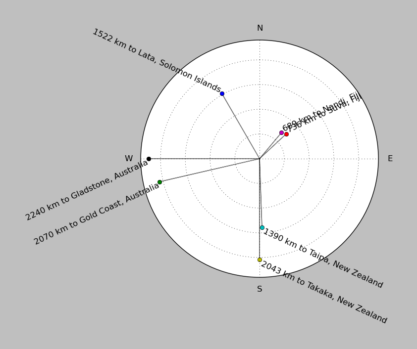
| ||||||||||||||||
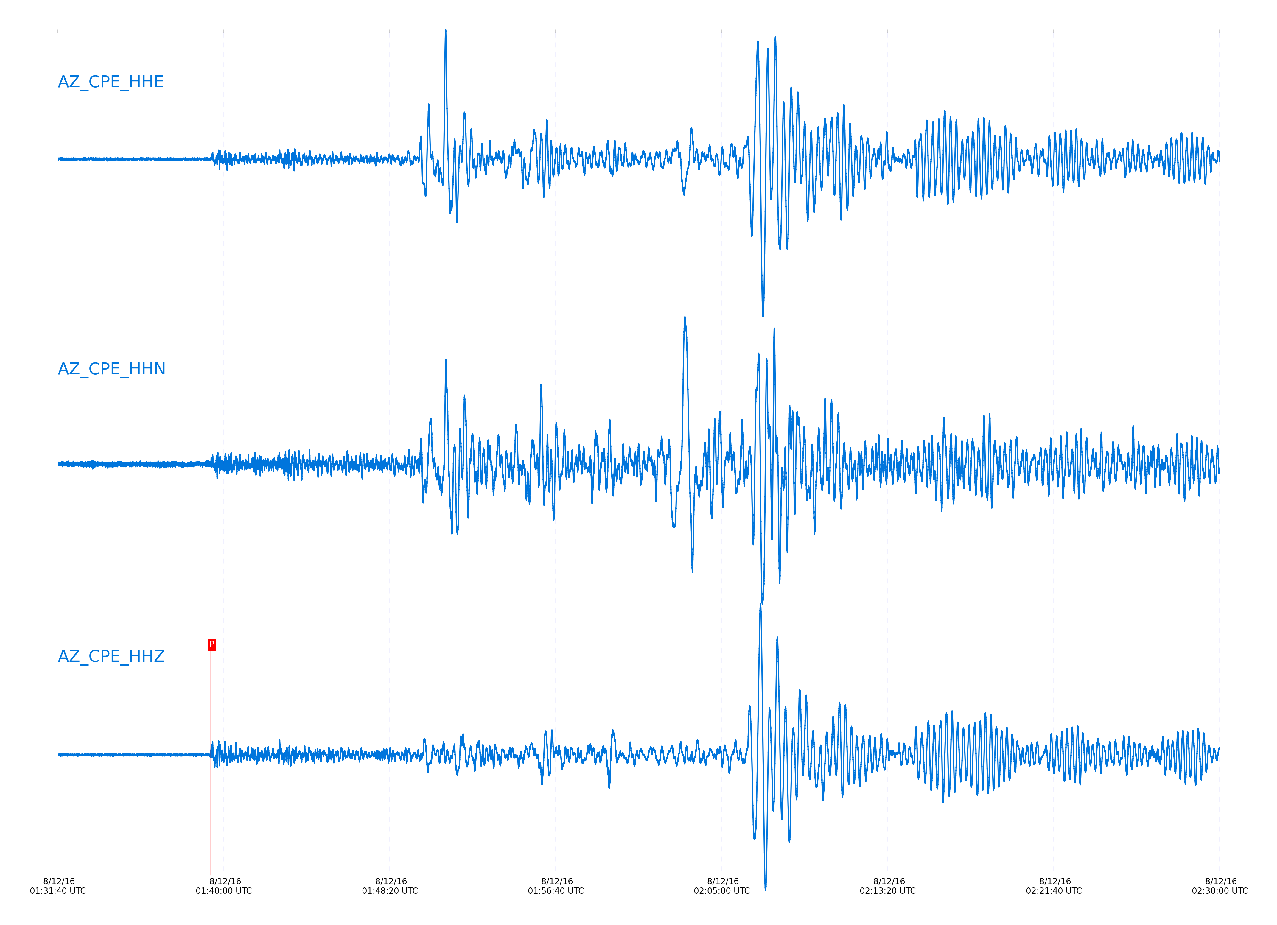
Event and active stations
|
|||||||||||||||||
Closest station with identified signal. Not filtered.
Subset of several stations close to the event. Not filtered.
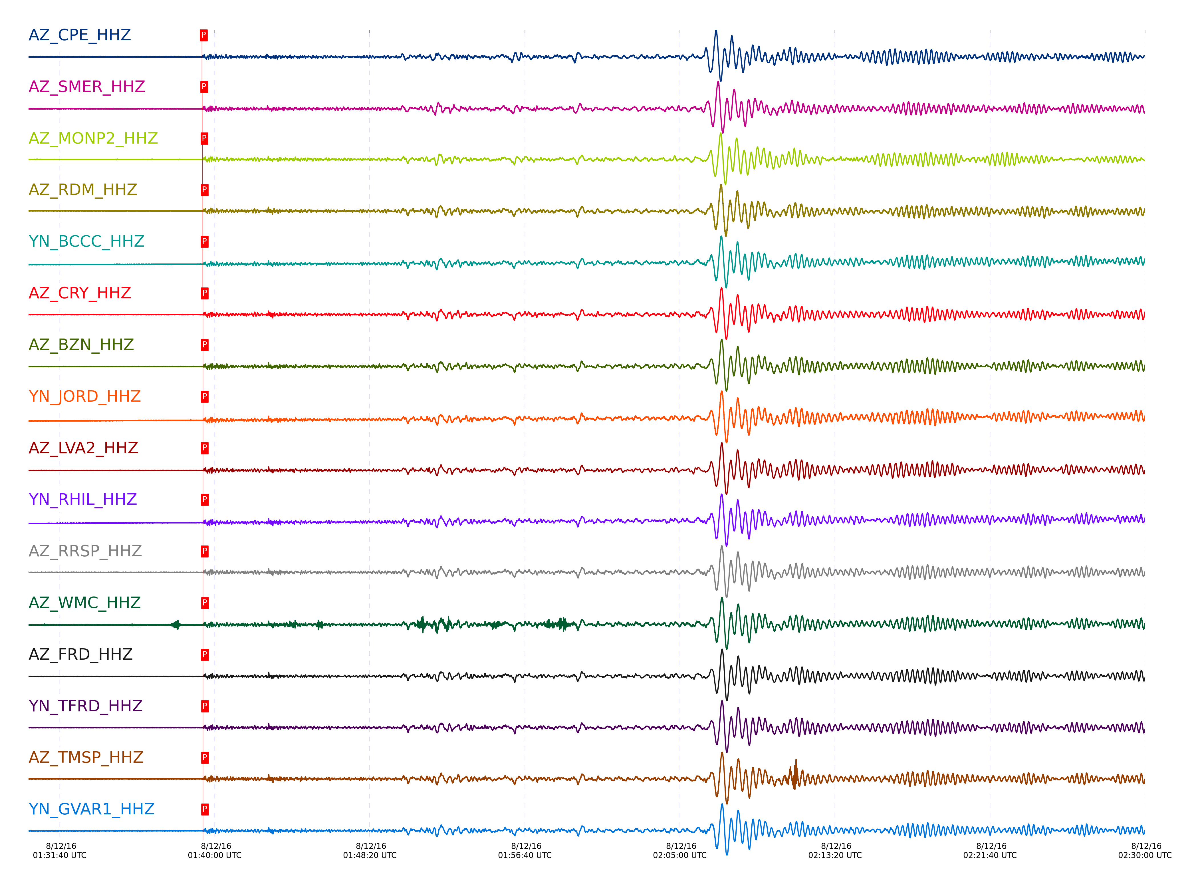
| STA_CHAN | S-E Delta | S-E Azimuth | Phase | Time | Signal/Noise | Time Residual | V. Model | Auth | arid |
|---|---|---|---|---|---|---|---|---|---|
| CPE_HHZ | 86.541° | 240.29° | P | 2016-08-12 01:39:18.5342 UTC | -1 | 0.134 | iasp91 | dbp:jtytell:162 | 1151012 |
| SMER_HHZ | 86.775° | 240.23° | P | 2016-08-12 01:39:19.6804 UTC | -1 | 0.134 | iasp91 | dbp:jtytell:162 | 1151013 |
| MONP2_HHZ | 87.041° | 240.68° | P | 2016-08-12 01:39:20.6084 UTC | 28.203 | -0.233 | iasp91 | dbp:jtytell:162 | 1150080 |
| RDM_HHZ | 87.094° | 240.4° | P | 2016-08-12 01:39:21.4531 UTC | 34.694 | 0.354 | iasp91 | dbp:jtytell:162 | 1150072 |
| BCCC_HHZ | 87.129° | 240.43° | P | 2016-08-12 01:39:21.3302 UTC | 33.696 | 0.061 | iasp91 | dbp:jtytell:162 | 1150076 |
| CRY_HHZ | 87.142° | 240.47° | P | 2016-08-12 01:39:21.8568 UTC | 27.193 | 0.524 | iasp91 | dbp:jtytell:162 | 1150071 |
| BZN_HHZ | 87.157° | 240.51° | P | 2016-08-12 01:39:21.9275 UTC | 27.87 | 0.524 | iasp91 | dbp:jtytell:162 | 1150074 |
| JORD_HHZ | 87.163° | 240.53° | P | 2016-08-12 01:39:22.0185 UTC | 32.395 | 0.584 | iasp91 | dbp:jtytell:162 | 1150075 |
| LVA2_HHZ | 87.165° | 240.58° | P | 2016-08-12 01:39:21.9656 UTC | 30.207 | 0.524 | iasp91 | dbp:jtytell:162 | 1150073 |
| RHIL_HHZ | 87.171° | 240.45° | P | 2016-08-12 01:39:22.2932 UTC | -1 | 0.823 | iasp91 | dbp:jtytell:162 | 1151020 |
| RRSP_HHZ | 87.183° | 240.47° | P | 2016-08-12 01:39:22.0548 UTC | -1 | 0.524 | iasp91 | dbp:jtytell:162 | 1151021 |
| WMC_HHZ | 87.192° | 240.51° | P | 2016-08-12 01:39:22.454 UTC | 19.488 | 0.882 | iasp91 | dbp:jtytell:162 | 1150079 |
| FRD_HHZ | 87.206° | 240.55° | P | 2016-08-12 01:39:22.2223 UTC | 22.864 | 0.584 | iasp91 | dbp:jtytell:162 | 1150077 |
| TFRD_HHZ | 87.206° | 240.55° | P | 2016-08-12 01:39:22.4016 UTC | -1 | 0.763 | iasp91 | dbp:jtytell:162 | 1151022 |
| TMSP_HHZ | 87.21° | 240.5° | P | 2016-08-12 01:39:22.4811 UTC | -1 | 0.823 | iasp91 | dbp:jtytell:162 | 1151023 |
| GVAR1_HHZ | 87.214° | 240.48° | P | 2016-08-12 01:39:22.5629 UTC | 23.459 | 0.882 | iasp91 | dbp:jtytell:162 | 1150081 |
| SND_HHZ | 87.226° | 240.54° | P | 2016-08-12 01:39:21.7836 UTC | 15.133 | 0.047 | iasp91 | dbp:jtytell:162 | 1150101 |
| KNW_HHZ | 87.234° | 240.48° | P | 2016-08-12 01:39:22.3001 UTC | 23.75 | 0.524 | iasp91 | dbp:jtytell:162 | 1150078 |
| TR04_HHZ | 87.287° | 240.66° | P | 2016-08-12 01:39:22.2554 UTC | -1 | 0.226 | iasp91 | dbp:jtytell:162 | 1151027 |
| TR03_HHZ | 87.294° | 240.66° | P | 2016-08-12 01:39:21.8127 UTC | -1 | -0.252 | iasp91 | dbp:jtytell:162 | 1151029 |
| TR02_HHZ | 87.303° | 240.66° | P | 2016-08-12 01:39:22.274 UTC | -1 | 0.166 | iasp91 | dbp:jtytell:162 | 1151031 |
| TR01_HHZ | 87.307° | 240.66° | P | 2016-08-12 01:39:21.5804 UTC | 20.419 | -0.55 | iasp91 | dbp:jtytell:162 | 1150083 |
| JFS4_HHZ | 87.314° | 240.67° | P | 2016-08-12 01:39:22.329 UTC | -1 | 0.166 | iasp91 | dbp:jtytell:162 | 1151032 |
| JFN4_HHZ | 87.317° | 240.67° | P | 2016-08-12 01:39:22.2253 UTC | -1 | 0.047 | iasp91 | dbp:jtytell:162 | 1151033 |
| TRO_HHZ | 87.348° | 240.65° | P | 2016-08-12 01:39:22.5506 UTC | -1 | 0.226 | iasp91 | dbp:jtytell:162 | 1151035 |
| PFO_HHZ | 87.367° | 240.63° | P | 2016-08-12 01:39:23.2379 UTC | 22.499 | 0.823 | iasp91 | dbp:jtytell:162 | 1150085 |
Click the link below to observe an interactive map of earthquakes recorded by the station deployment:
Broadband Seismic Data Collection Center (ANZA),
Institute of Geophysics & Planetary Physics
Scripps Institution of Oceanography,
University of California San Diego
Copyright © 1989 - 2014. All Rights Reserved.