
last update to page: August 25 2016 16:37:56 (UTC).
SummaryThe red marker denotes the earthquake epicenter. On Wed Aug 24th 2016 01:36:32 (UTC) the seismic network recorded an earthquake (preliminary 6 Mw) located in Central Italy. Seismic region Western Mediterranean Area. The epicentral distance (i.e. distance separating the location to the epicenter) to the closest station PFO in the network is 10,117.5 km. If you felt the quake, the USGS would like to know. Please add your comments to the USGS page "Did you feel it?". |
Details
Proximity to Population Centers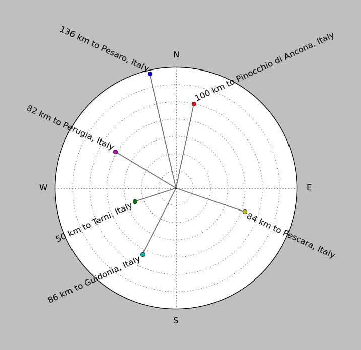
| ||||||||||||||||
Event and active stations
|
|||||||||||||||||
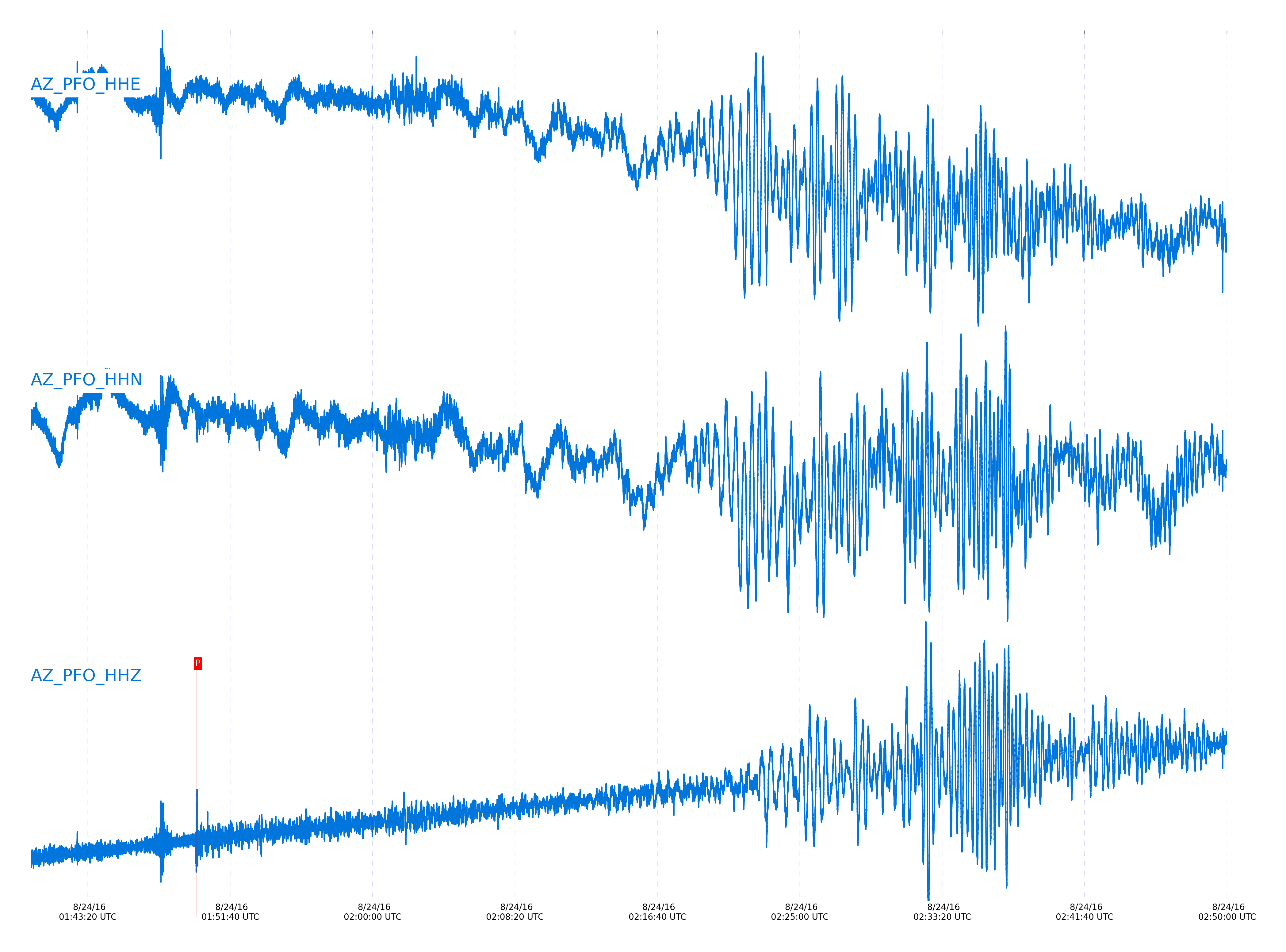
Closest station with identified signal. Not filtered.
Subset of several stations close to the event. Not filtered.
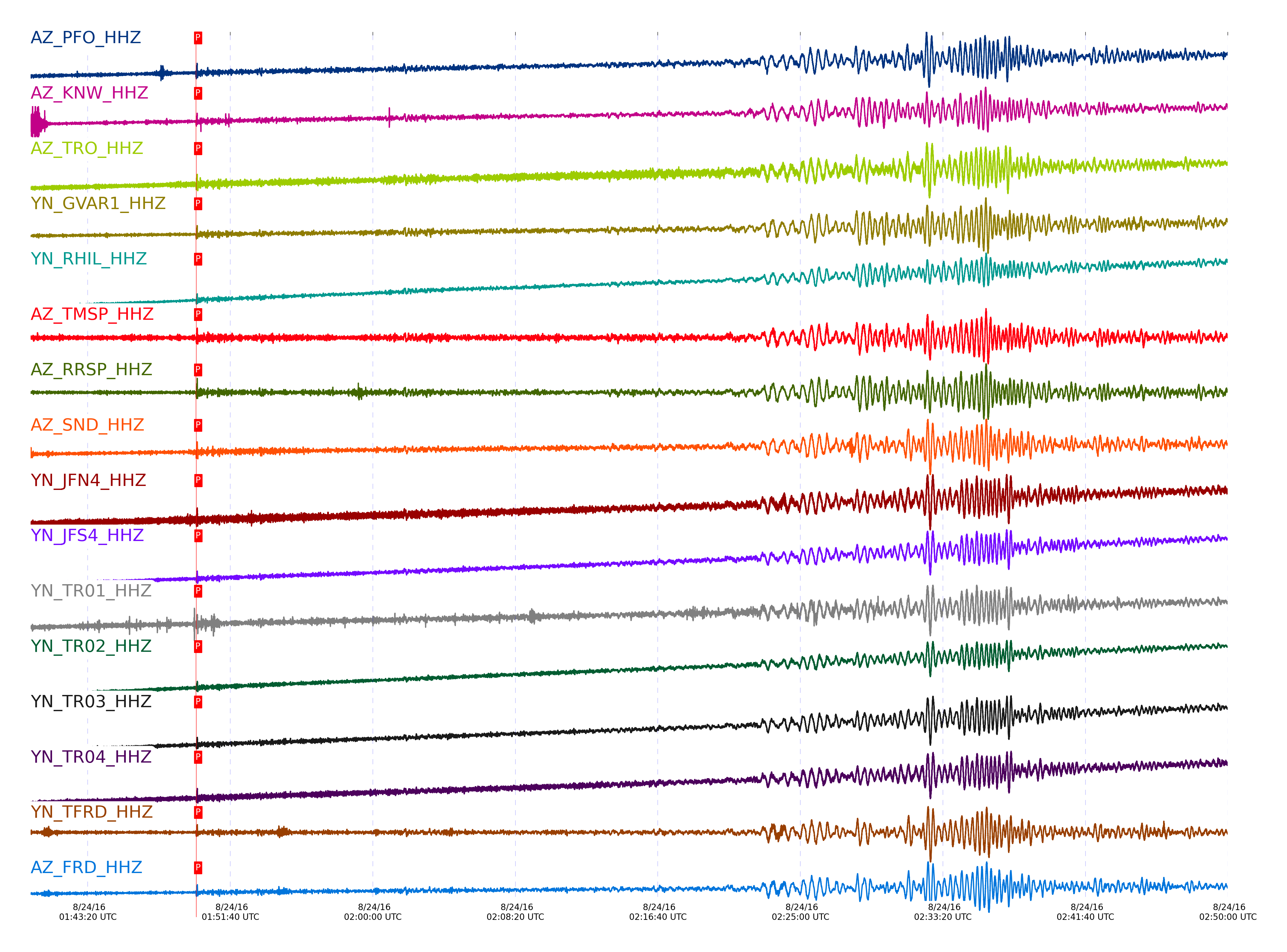
| STA_CHAN | S-E Delta | S-E Azimuth | Phase | Time | Signal/Noise | Time Residual | V. Model | Auth | arid |
|---|---|---|---|---|---|---|---|---|---|
| PFO_HHZ | 90.887° | 34.44° | pP | 2016-08-24 01:49:39.8305 UTC | -1 | 1.505 | iasp91 | dbp:jtytell:162 | 1165172 |
| KNW_HHZ | 90.921° | 34.29° | pP | 2016-08-24 01:49:39.838 UTC | -1 | 1.355 | iasp91 | dbp:jtytell:162 | 1165176 |
| TRO_HHZ | 90.944° | 34.46° | pP | 2016-08-24 01:49:40.2457 UTC | -1 | 1.656 | iasp91 | dbp:jtytell:162 | 1165177 |
| GVAR1_HHZ | 90.958° | 34.3° | pP | 2016-08-24 01:49:39.9087 UTC | -1 | 1.254 | iasp91 | dbp:jtytell:162 | 1165178 |
| RHIL_HHZ | 90.983° | 34.26° | pP | 2016-08-24 01:49:40.4264 UTC | -1 | 1.657 | iasp91 | dbp:jtytell:162 | 1165180 |
| TMSP_HHZ | 90.985° | 34.31° | pP | 2016-08-24 01:49:40.4365 UTC | -1 | 1.657 | iasp91 | dbp:jtytell:162 | 1165181 |
| RRSP_HHZ | 90.986° | 34.28° | pP | 2016-08-24 01:49:40.1376 UTC | -1 | 1.354 | iasp91 | dbp:jtytell:162 | 1165183 |
| SND_HHZ | 91.009° | 34.35° | pP | 2016-08-24 01:49:40.445 UTC | -1 | 1.556 | iasp91 | dbp:jtytell:162 | 1165185 |
| JFN4_HHZ | 91.014° | 34.47° | pP | 2016-08-24 01:49:41.174 UTC | -1 | 2.261 | iasp91 | dbp:jtytell:162 | 1165192 |
| JFS4_HHZ | 91.017° | 34.47° | pP | 2016-08-24 01:49:41.0379 UTC | -1 | 2.11 | iasp91 | dbp:jtytell:162 | 1165190 |
| WMC_HHZ | 91.02° | 34.32° | pP | 2016-08-24 01:49:40.9001 UTC | -1 | 1.959 | iasp91 | dbp:jtytell:162 | 1165189 |
| TR01_HHZ | 91.021° | 34.46° | pP | 2016-08-24 01:49:40.5023 UTC | -1 | 1.555 | iasp91 | dbp:jtytell:162 | 1165191 |
| TR02_HHZ | 91.026° | 34.46° | pP | 2016-08-24 01:49:40.1237 UTC | -1 | 1.152 | iasp91 | dbp:jtytell:162 | 1165193 |
| TR03_HHZ | 91.037° | 34.46° | pP | 2016-08-24 01:49:40.5245 UTC | -1 | 1.505 | iasp91 | dbp:jtytell:162 | 1165194 |
| TR04_HHZ | 91.047° | 34.46° | pP | 2016-08-24 01:49:40.4704 UTC | -1 | 1.404 | iasp91 | dbp:jtytell:162 | 1165196 |
| TFRD_HHZ | 91.051° | 34.36° | pP | 2016-08-24 01:49:40.5897 UTC | -1 | 1.505 | iasp91 | dbp:jtytell:162 | 1165198 |
| FRD_HHZ | 91.051° | 34.36° | pP | 2016-08-24 01:49:40.4892 UTC | -1 | 1.404 | iasp91 | dbp:jtytell:162 | 1165199 |
| RDM_HHZ | 91.054° | 34.22° | pP | 2016-08-24 01:49:40.5061 UTC | -1 | 1.405 | iasp91 | dbp:jtytell:162 | 1165200 |
| CRY_HHZ | 91.056° | 34.28° | pP | 2016-08-24 01:49:40.6141 UTC | -1 | 1.506 | iasp91 | dbp:jtytell:162 | 1165201 |
| BZN_HHZ | 91.084° | 34.32° | pP | 2016-08-24 01:49:40.6429 UTC | -1 | 1.405 | iasp91 | dbp:jtytell:162 | 1165203 |
| JORD_HHZ | 91.089° | 34.33° | pP | 2016-08-24 01:49:40.5175 UTC | -1 | 1.253 | iasp91 | dbp:jtytell:162 | 1165204 |
| LVA2_HHZ | 91.15° | 34.38° | pP | 2016-08-24 01:49:41.0483 UTC | -1 | 1.505 | iasp91 | dbp:jtytell:162 | 1165207 |
| SMER_HHZ | 91.348° | 34.04° | pP | 2016-08-24 01:49:41.1608 UTC | -1 | 0.7 | iasp91 | dbp:jtytell:162 | 1165209 |
| MONP2_HHZ | 91.463° | 34.47° | pP | 2016-08-24 01:49:42.2455 UTC | -1 | 1.252 | iasp91 | dbp:jtytell:162 | 1165211 |
Click the link below to observe an interactive map of earthquakes recorded by the station deployment:
Broadband Seismic Data Collection Center (ANZA),
Institute of Geophysics & Planetary Physics
Scripps Institution of Oceanography,
University of California San Diego
Copyright © 1989 - 2014. All Rights Reserved.