
last update to page: September 03 2016 20:03:01 (UTC).
SummaryThe red marker denotes the earthquake epicenter. On Sat Sep 3rd 2016 12:02:44 (UTC) the seismic network recorded an earthquake (preliminary 5.6 mwr) located in Oklahoma. Seismic region Eastern North America. The epicentral distance (i.e. distance separating the location to the epicenter) to the closest station TONN in the network is 1,788.8 km. If you felt the quake, the USGS would like to know. Please add your comments to the USGS page "Did you feel it?". |
Details
Proximity to Population Centers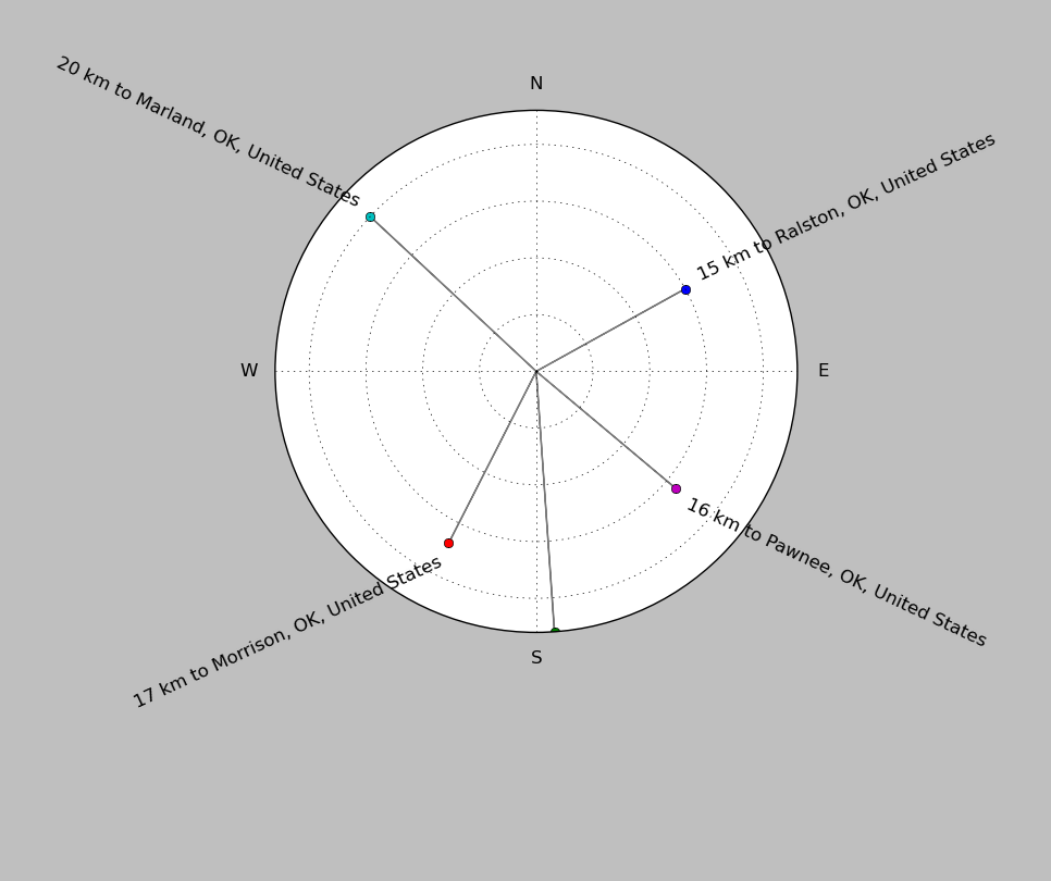
| ||||||||||||||||
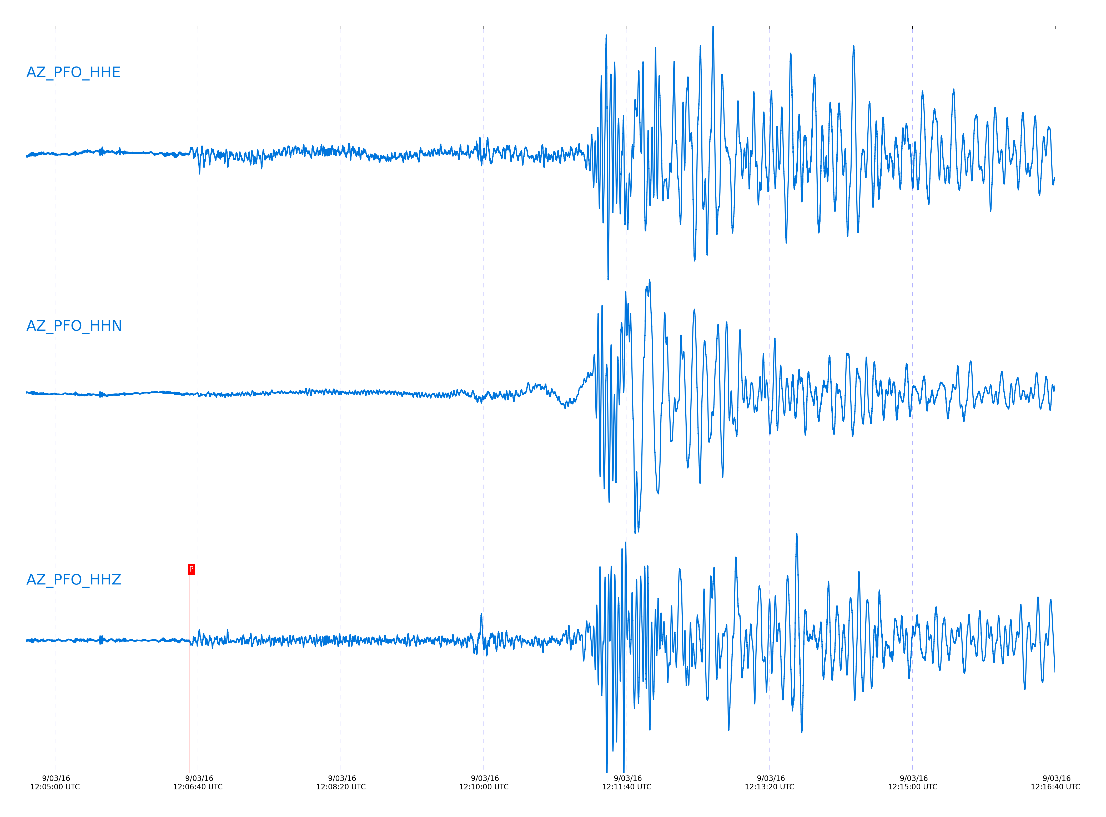
Event and active stations
|
|||||||||||||||||
Closest station with identified signal. Not filtered.
Subset of several stations close to the event. Not filtered.
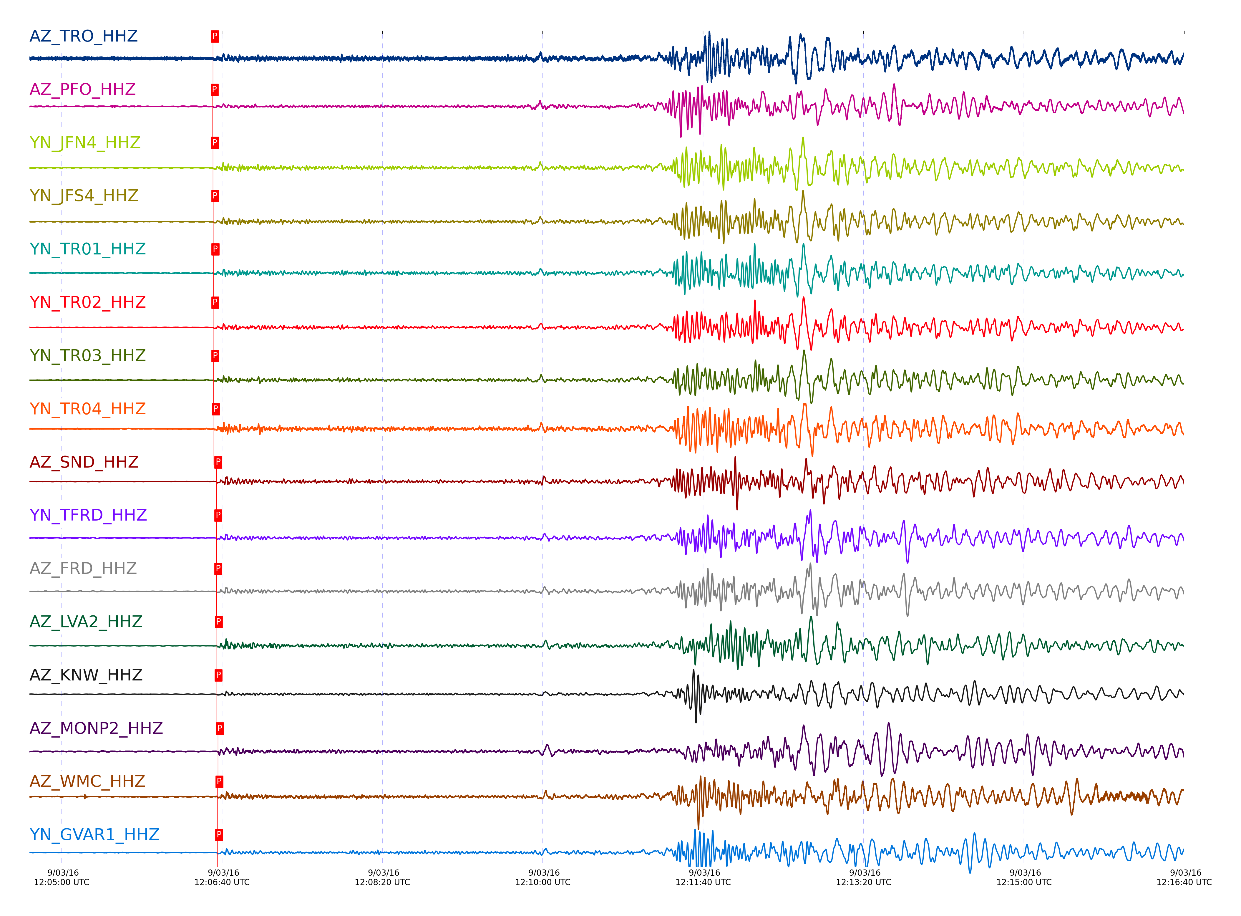
| STA_CHAN | S-E Delta | S-E Azimuth | Phase | Time | Signal/Noise | Time Residual | V. Model | Auth | arid |
|---|---|---|---|---|---|---|---|---|---|
| TRO_HHZ | 16.207° | 74.16° | pPn | 2016-09-03 12:06:34.3886 UTC | 69.343 | 0.203 | iasp91 | dbp:jtytell:162 | 1176840 |
| PFO_HHZ | 16.21° | 74.46° | pPn | 2016-09-03 12:06:34.2269 UTC | 41.29 | 0 | iasp91 | dbp:jtytell:162 | 1176839 |
| JFN4_HHZ | 16.214° | 73.82° | pPn | 2016-09-03 12:06:34.3315 UTC | -1 | 0.051 | iasp91 | dbp:jtytell:162 | 1177120 |
| JFS4_HHZ | 16.217° | 73.82° | pPn | 2016-09-03 12:06:34.5717 UTC | -1 | 0.253 | iasp91 | dbp:jtytell:162 | 1177122 |
| TR01_HHZ | 16.225° | 73.82° | pPn | 2016-09-03 12:06:34.7045 UTC | 77.809 | 0.288 | iasp91 | dbp:jtytell:162 | 1176844 |
| TR02_HHZ | 16.229° | 73.81° | pPn | 2016-09-03 12:06:34.5632 UTC | -1 | 0.096 | iasp91 | dbp:jtytell:162 | 1177123 |
| TR03_HHZ | 16.236° | 73.78° | pPn | 2016-09-03 12:06:34.6376 UTC | -1 | 0.072 | iasp91 | dbp:jtytell:162 | 1177124 |
| TR04_HHZ | 16.241° | 73.75° | pPn | 2016-09-03 12:06:34.9672 UTC | -1 | -0.274 | iasp91 | dbp:jtytell:162 | 1177125 |
| SND_HHZ | 16.349° | 74.29° | pPn | 2016-09-03 12:06:36.5141 UTC | 60.322 | -0.193 | iasp91 | dbp:jtytell:162 | 1176857 |
| TFRD_HHZ | 16.356° | 74.1° | pPn | 2016-09-03 12:06:36.5074 UTC | -1 | -0.294 | iasp91 | dbp:jtytell:162 | 1177129 |
| FRD_HHZ | 16.356° | 74.1° | pPn | 2016-09-03 12:06:36.4598 UTC | 60.293 | -0.342 | iasp91 | dbp:jtytell:162 | 1176845 |
| LVA2_HHZ | 16.363° | 73.63° | pPn | 2016-09-03 12:06:36.7906 UTC | 90.356 | -0.108 | iasp91 | dbp:jtytell:162 | 1176858 |
| KNW_HHZ | 16.385° | 74.85° | pPn | 2016-09-03 12:06:36.6905 UTC | 90.249 | 0.212 | iasp91 | dbp:jtytell:162 | 1176859 |
| MONP2_HHZ | 16.387° | 72.09° | pPn | 2016-09-03 12:06:37.5292 UTC | 63.222 | 0.233 | iasp91 | dbp:jtytell:162 | 1176862 |
| WMC_HHZ | 16.393° | 74.38° | pPn | 2016-09-03 12:06:37.1447 UTC | 67.365 | -0.157 | iasp91 | dbp:jtytell:162 | 1176863 |
| GVAR1_HHZ | 16.394° | 74.69° | pPn | 2016-09-03 12:06:37.0122 UTC | 65.33 | -0.301 | iasp91 | dbp:jtytell:162 | 1176861 |
| JORD_HHZ | 16.397° | 74.04° | pPn | 2016-09-03 12:06:37.1209 UTC | 95.015 | -0.232 | iasp91 | dbp:jtytell:162 | 1176847 |
| BZN_HHZ | 16.409° | 74.11° | pPn | 2016-09-03 12:06:37.2546 UTC | 104.93 | -0.266 | iasp91 | dbp:jtytell:162 | 1176860 |
| RRSP_HHZ | 16.424° | 74.65° | pPn | 2016-09-03 12:06:37.3742 UTC | -1 | -0.351 | iasp91 | dbp:jtytell:162 | 1177133 |
| RHIL_HHZ | 16.444° | 74.72° | pPn | 2016-09-03 12:06:37.8672 UTC | -1 | -0.128 | iasp91 | dbp:jtytell:162 | 1177134 |
| CRY_HHZ | 16.445° | 74.36° | pPn | 2016-09-03 12:06:37.7658 UTC | 85.316 | -0.249 | iasp91 | dbp:jtytell:162 | 1176864 |
| RDM_HHZ | 16.517° | 74.6° | pPn | 2016-09-03 12:06:38.5554 UTC | 123.18 | 0.4 | iasp91 | dbp:jtytell:162 | 1176865 |
| SMER_HHZ | 16.822° | 74.11° | Pn | 2016-09-03 12:06:42.4295 UTC | 70.376 | 0.349 | iasp91 | dbp:jtytell:162 | 1176867 |
| CPE_HHZ | 16.934° | 72.3° | pPn | 2016-09-03 12:06:44.7249 UTC | 55.615 | 0.023 | iasp91 | dbp:jtytell:162 | 1176870 |
| SOL_HHZ | 17.063° | 72.19° | pPn | 2016-09-03 12:06:46.6332 UTC | 36.942 | 0.185 | iasp91 | dbp:jtytell:162 | 1176871 |
Click the link below to observe an interactive map of earthquakes recorded by the station deployment:
Broadband Seismic Data Collection Center (ANZA),
Institute of Geophysics & Planetary Physics
Scripps Institution of Oceanography,
University of California San Diego
Copyright © 1989 - 2014. All Rights Reserved.