
last update to page: October 31 2016 18:32:17 (UTC).
SummaryThe red marker denotes the earthquake epicenter. On Sun Oct 30th 2016 06:40:19 (UTC) the seismic network recorded an earthquake (preliminary 6.6 mww) located in Central Italy. Seismic region Western Mediterranean Area. The epicentral distance (i.e. distance separating the location to the epicenter) to the closest station PFO in the network is 10,096.8 km. If you felt the quake, the USGS would like to know. Please add your comments to the USGS page "Did you feel it?". |
Details
Proximity to Population Centers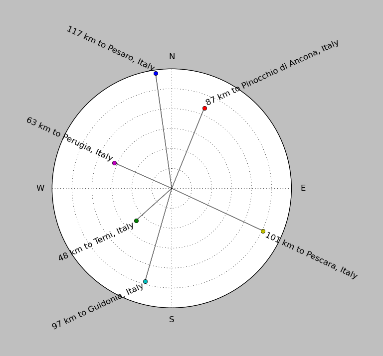
| ||||||||||||||||
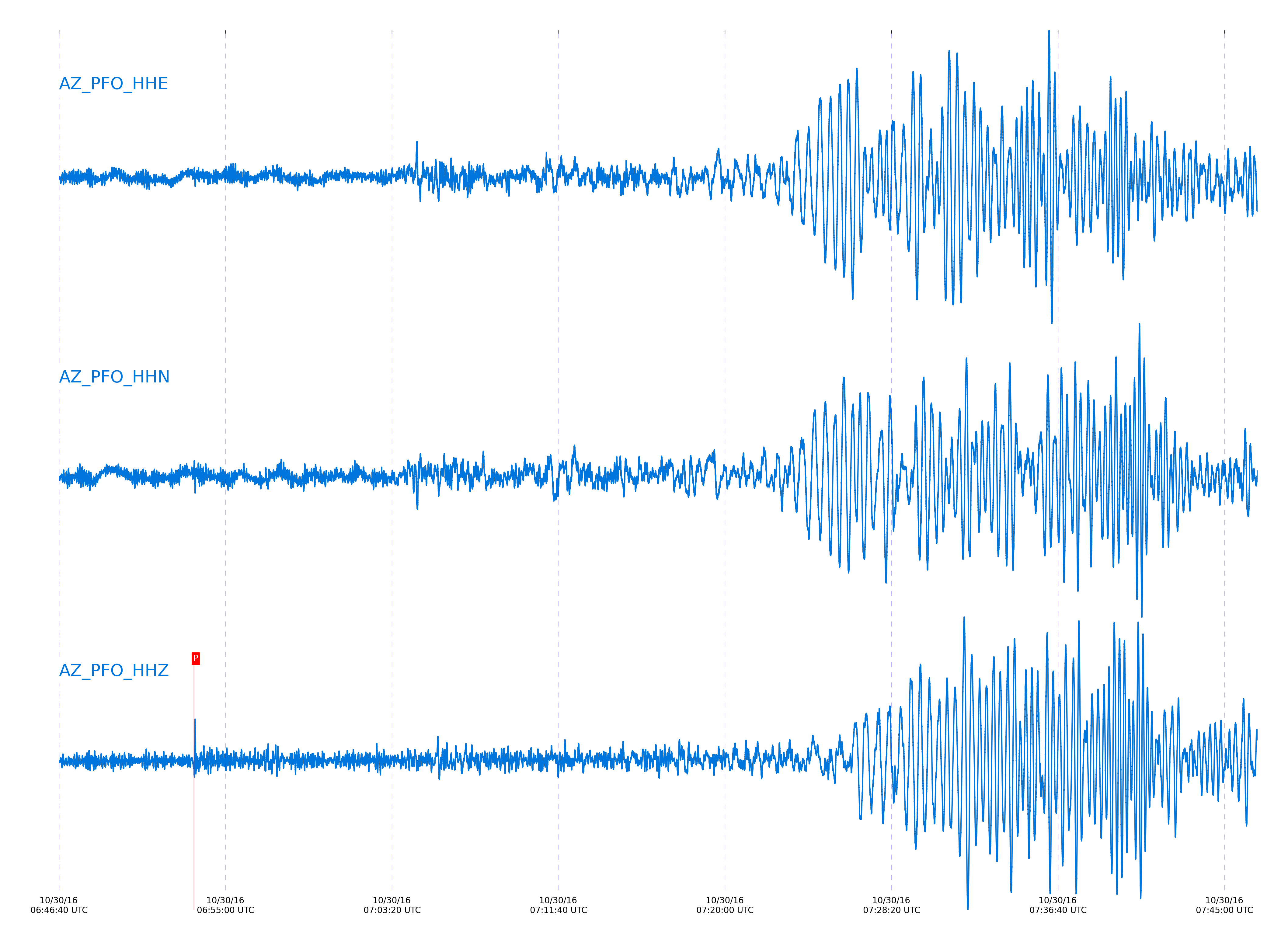
Event and active stations
|
|||||||||||||||||
Closest station with identified signal. Not filtered.
Subset of several stations close to the event. Not filtered.
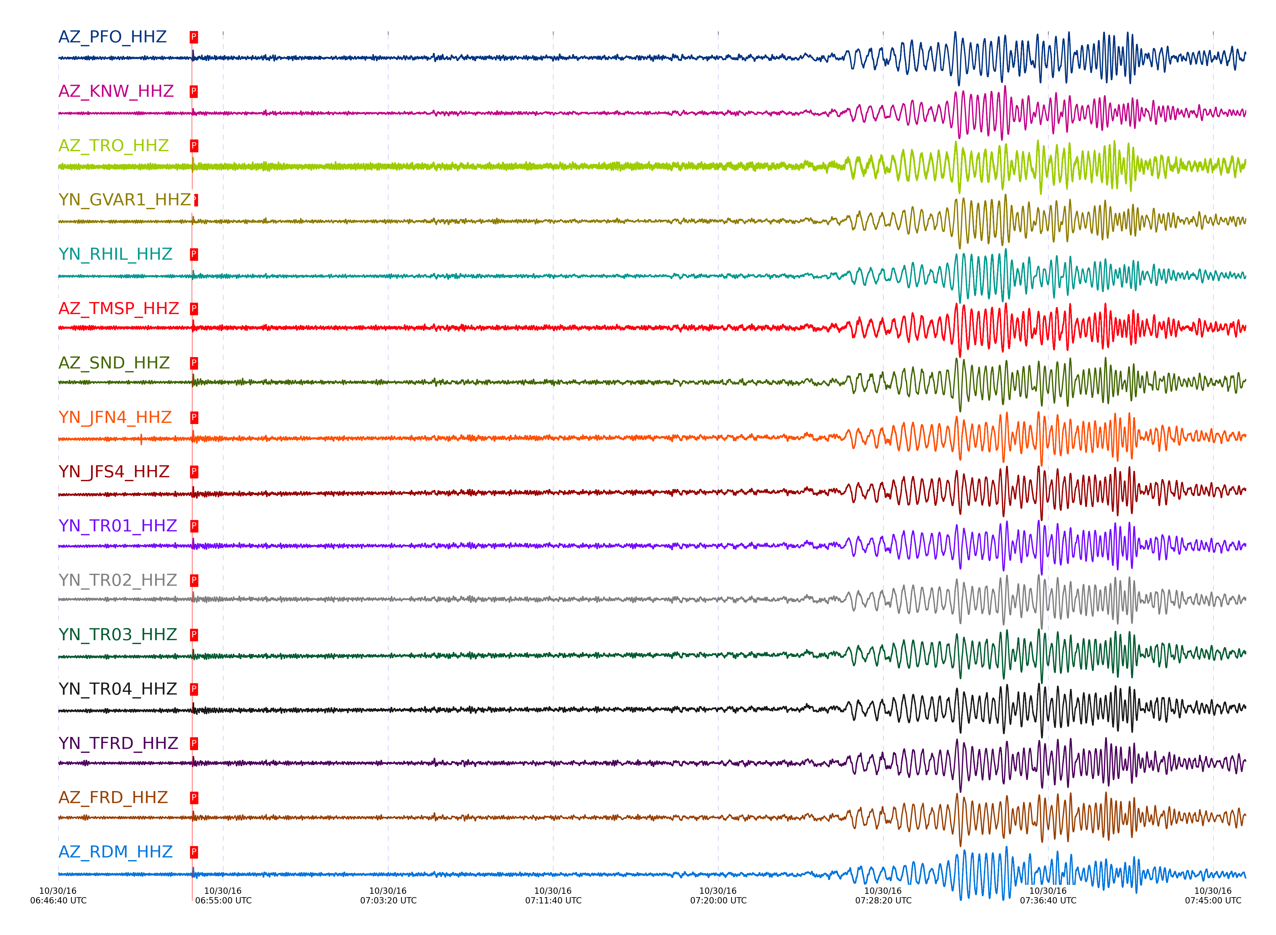
| STA_CHAN | S-E Delta | S-E Azimuth | Phase | Time | Signal/Noise | Time Residual | V. Model | Auth | arid |
|---|---|---|---|---|---|---|---|---|---|
| PFO_HHZ | 90.701° | 34.42° | pP | 2016-10-30 06:53:24.6771 UTC | 25.164 | -0.804 | iasp91 | dbp:jtytell:163 | 1253980 |
| KNW_HHZ | 90.735° | 34.28° | pP | 2016-10-30 06:53:24.6359 UTC | 36.202 | -1.003 | iasp91 | dbp:jtytell:163 | 1253995 |
| TRO_HHZ | 90.758° | 34.44° | pP | 2016-10-30 06:53:25.7385 UTC | 35.193 | -0.007 | iasp91 | dbp:jtytell:163 | 1254003 |
| GVAR1_HHZ | 90.772° | 34.28° | pP | 2016-10-30 06:53:24.9074 UTC | 25.58 | -0.903 | iasp91 | dbp:jtytell:163 | 1254001 |
| RHIL_HHZ | 90.796° | 34.25° | pP | 2016-10-30 06:53:25.2208 UTC | -1 | -0.704 | iasp91 | dbp:jtytell:163 | 1255686 |
| TMSP_HHZ | 90.799° | 34.3° | pP | 2016-10-30 06:53:25.4305 UTC | -1 | -0.505 | iasp91 | dbp:jtytell:163 | 1255687 |
| SND_HHZ | 90.822° | 34.34° | pP | 2016-10-30 06:53:25.4406 UTC | 19.062 | -0.605 | iasp91 | dbp:jtytell:163 | 1254016 |
| JFN4_HHZ | 90.827° | 34.46° | pP | 2016-10-30 06:53:26.0125 UTC | -1 | -0.057 | iasp91 | dbp:jtytell:163 | 1255694 |
| JFS4_HHZ | 90.831° | 34.46° | pP | 2016-10-30 06:53:25.6291 UTC | -1 | -0.455 | iasp91 | dbp:jtytell:163 | 1255692 |
| TR01_HHZ | 90.835° | 34.45° | pP | 2016-10-30 06:53:26.0964 UTC | 10.627 | -0.007 | iasp91 | dbp:jtytell:163 | 1254006 |
| BCCC_HHZ | 90.837° | 34.23° | pP | 2016-10-30 06:53:25.3077 UTC | -1 | -0.804 | iasp91 | dbp:jtytell:163 | 1255695 |
| TR02_HHZ | 90.84° | 34.45° | pP | 2016-10-30 06:53:25.7227 UTC | -1 | -0.405 | iasp91 | dbp:jtytell:163 | 1255696 |
| TR03_HHZ | 90.85° | 34.45° | pP | 2016-10-30 06:53:25.422 UTC | -1 | -0.754 | iasp91 | dbp:jtytell:163 | 1255698 |
| TR04_HHZ | 90.861° | 34.44° | pP | 2016-10-30 06:53:25.4688 UTC | -1 | -0.754 | iasp91 | dbp:jtytell:163 | 1255700 |
| TFRD_HHZ | 90.864° | 34.34° | pP | 2016-10-30 06:53:25.4866 UTC | -1 | -0.754 | iasp91 | dbp:jtytell:163 | 1255702 |
| FRD_HHZ | 90.864° | 34.34° | pP | 2016-10-30 06:53:25.736 UTC | 20.677 | -0.505 | iasp91 | dbp:jtytell:163 | 1254015 |
| RDM_HHZ | 90.868° | 34.21° | pP | 2016-10-30 06:53:25.503 UTC | 30.232 | -0.754 | iasp91 | dbp:jtytell:163 | 1253998 |
| CRY_HHZ | 90.869° | 34.27° | pP | 2016-10-30 06:53:25.4607 UTC | 21.389 | -0.804 | iasp91 | dbp:jtytell:163 | 1253997 |
| BZN_HHZ | 90.898° | 34.31° | pP | 2016-10-30 06:53:25.541 UTC | 12.17 | -0.854 | iasp91 | dbp:jtytell:163 | 1254009 |
| JORD_HHZ | 90.903° | 34.32° | pP | 2016-10-30 06:53:25.6168 UTC | 15.818 | -0.804 | iasp91 | dbp:jtytell:163 | 1254010 |
| LVA2_HHZ | 90.963° | 34.37° | pP | 2016-10-30 06:53:25.8962 UTC | 10.793 | -0.804 | iasp91 | dbp:jtytell:163 | 1254013 |
| SMER_HHZ | 91.162° | 34.02° | PcP | 2016-10-30 06:53:26.2167 UTC | -1 | 1.136 | iasp91 | dbp:jtytell:163 | 1255708 |
| MONP2_HHZ | 91.277° | 34.45° | pP | 2016-10-30 06:53:27.4474 UTC | -1 | -0.705 | iasp91 | dbp:jtytell:163 | 1255710 |
| CPE_HHZ | 91.602° | 34.07° | pP | 2016-10-30 06:53:28.5539 UTC | -1 | -1.103 | iasp91 | dbp:jtytell:163 | 1255720 |
Click the link below to observe an interactive map of earthquakes recorded by the station deployment:
Broadband Seismic Data Collection Center (ANZA),
Institute of Geophysics & Planetary Physics
Scripps Institution of Oceanography,
University of California San Diego
Copyright © 1989 - 2014. All Rights Reserved.