
last update to page: November 26 2016 21:49:59 (UTC).
SummaryThe red marker denotes the earthquake epicenter. On Thu Nov 24th 2016 18:43:48 (UTC) the seismic network recorded an earthquake (preliminary 7 mww) located in Off Coast Of Central America. Seismic region Central America. The epicentral distance (i.e. distance separating the location to the epicenter) to the closest station USGCB in the network is 3,633.0 km. If you felt the quake, the USGS would like to know. Please add your comments to the USGS page "Did you feel it?". |
Details
Proximity to Population Centers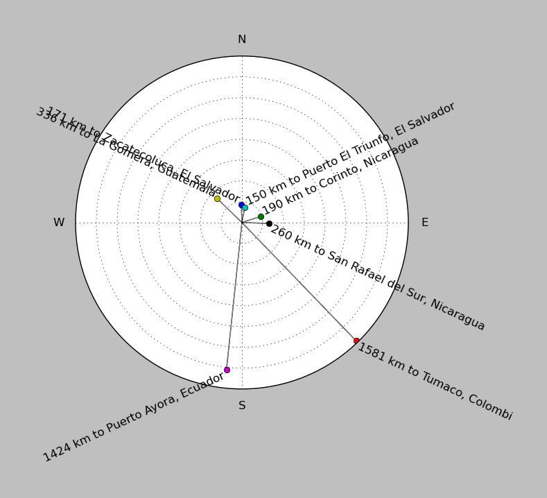
| ||||||||||||||||
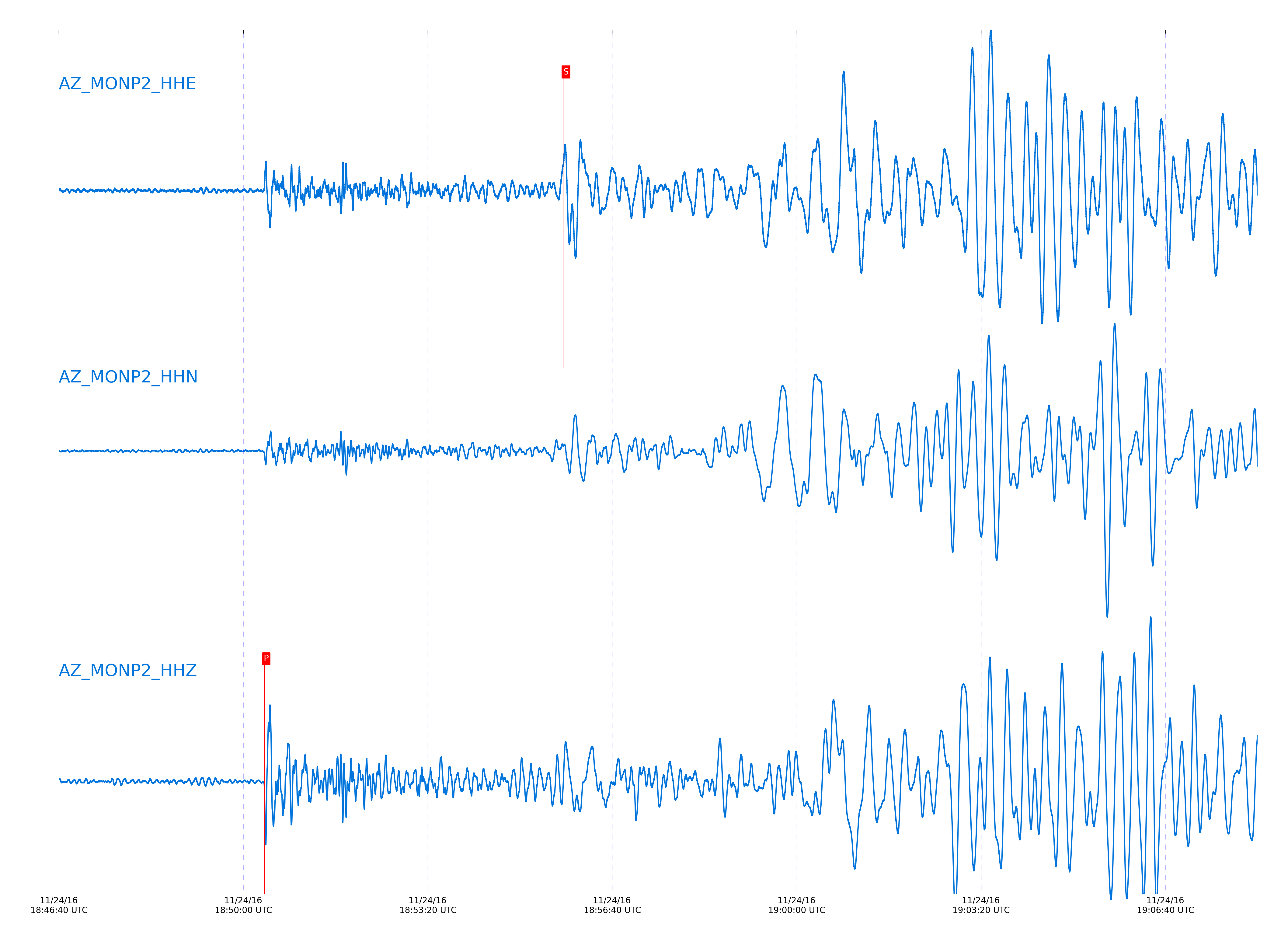
Event and active stations
|
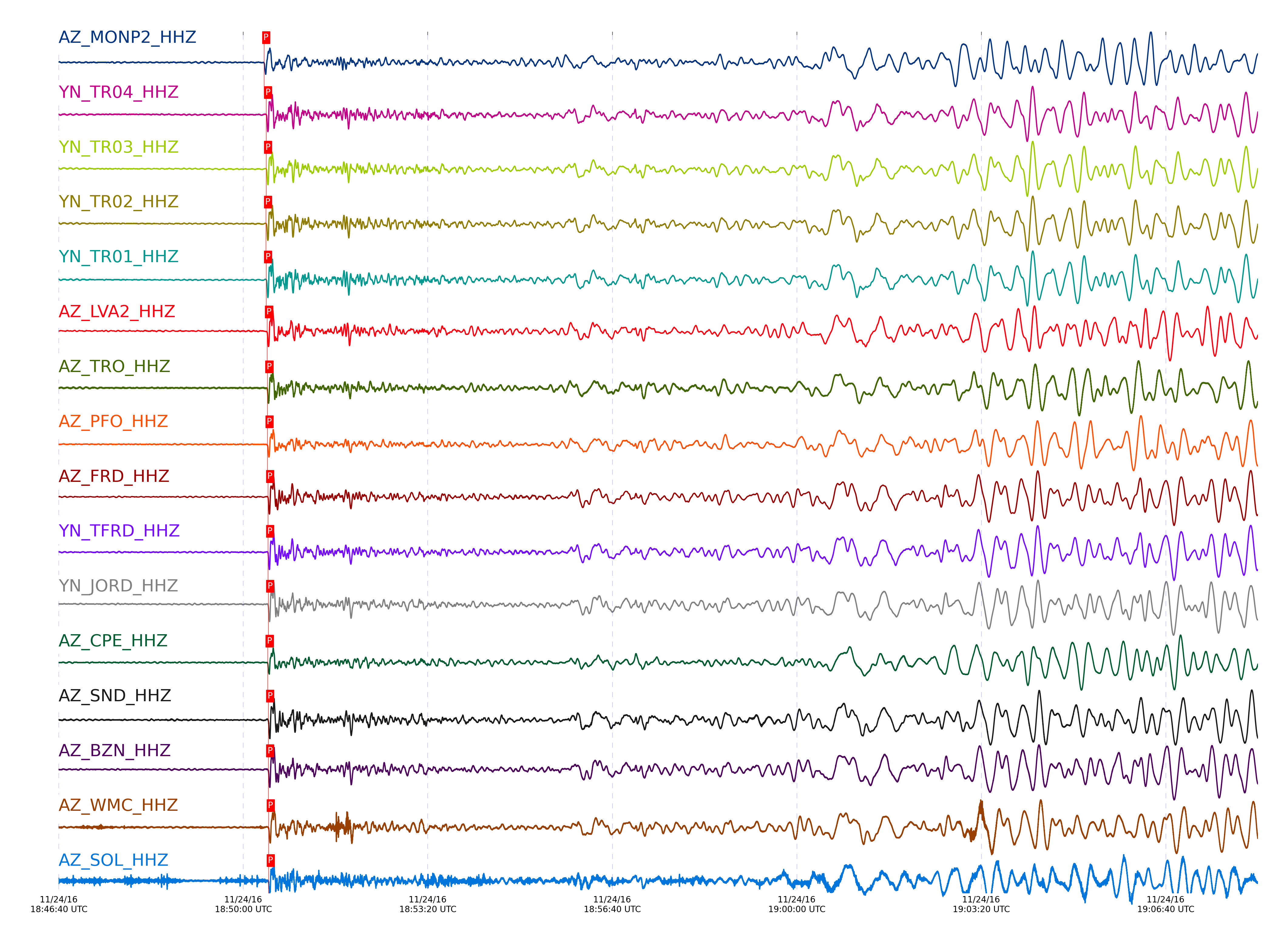
|||||||||||||||||
Closest station with identified signal. Not filtered.
Subset of several stations close to the event. Not filtered.
| STA_CHAN | S-E Delta | S-E Azimuth | Phase | Time | Signal/Noise | Time Residual | V. Model | Auth | arid |
|---|---|---|---|---|---|---|---|---|---|
| MONP2_HHZ | 32.795° | 123.24° | P | 2016-11-24 18:50:22.69 UTC | -1 | 0.593 | iasp91 | dbp:jtytell:163 | 1278525 |
| MONP2_HHE | 32.795° | 123.24° | S | 2016-11-24 18:55:47.4551 UTC | -1 | 7.468 | iasp91 | dbp:jtytell:163 | 1278609 |
| TR04_HHZ | 33.078° | 123.88° | P | 2016-11-24 18:50:24.7234 UTC | -1 | 0.16 | iasp91 | dbp:jtytell:163 | 1278534 |
| TR04_HHE | 33.078° | 123.88° | S | 2016-11-24 18:55:48.8454 UTC | -1 | 4.474 | iasp91 | dbp:jtytell:163 | 1278619 |
| TR03_HHZ | 33.082° | 123.9° | P | 2016-11-24 18:50:24.6869 UTC | -1 | 0.088 | iasp91 | dbp:jtytell:163 | 1278535 |
| TR03_HHE | 33.082° | 123.9° | S | 2016-11-24 18:55:49.0964 UTC | -1 | 4.662 | iasp91 | dbp:jtytell:163 | 1278620 |
| TR02_HHZ | 33.083° | 123.92° | P | 2016-11-24 18:50:24.6002 UTC | -1 | -0.002 | iasp91 | dbp:jtytell:163 | 1278536 |
| TR02_HHE | 33.083° | 123.92° | S | 2016-11-24 18:55:49.0999 UTC | -1 | 4.659 | iasp91 | dbp:jtytell:163 | 1278621 |
| TR01_HHZ | 33.083° | 123.93° | P | 2016-11-24 18:50:24.6929 UTC | -1 | 0.088 | iasp91 | dbp:jtytell:163 | 1278537 |
| TR01_HHE | 33.083° | 123.93° | S | 2016-11-24 18:55:49.5328 UTC | -1 | 5.087 | iasp91 | dbp:jtytell:163 | 1278622 |
| LVA2_HHZ | 33.146° | 123.65° | P | 2016-11-24 18:50:25.8198 UTC | -1 | 0.665 | iasp91 | dbp:jtytell:163 | 1278541 |
| LVA2_HHE | 33.146° | 123.65° | S | 2016-11-24 18:55:50.5127 UTC | -1 | 5.09 | iasp91 | dbp:jtytell:163 | 1278624 |
| TRO_HHZ | 33.147° | 124.04° | P | 2016-11-24 18:50:26.1223 UTC | -1 | 0.954 | iasp91 | dbp:jtytell:163 | 1278542 |
| TRO_HHE | 33.147° | 124.04° | S | 2016-11-24 18:55:50.5264 UTC | -1 | 5.08 | iasp91 | dbp:jtytell:163 | 1278625 |
| PFO_HHZ | 33.22° | 124.11° | P | 2016-11-24 18:50:26.1963 UTC | -1 | 0.395 | iasp91 | dbp:jtytell:163 | 1278553 |
| PFO_HHE | 33.22° | 124.11° | S | 2016-11-24 18:55:51.3752 UTC | -1 | 4.802 | iasp91 | dbp:jtytell:163 | 1278632 |
| FRD_HHZ | 33.254° | 123.78° | P | 2016-11-24 18:50:26.8841 UTC | -1 | 0.792 | iasp91 | dbp:jtytell:163 | 1278557 |
| FRD_HHE | 33.254° | 123.78° | S | 2016-11-24 18:55:52.3116 UTC | -1 | 5.221 | iasp91 | dbp:jtytell:163 | 1278635 |
| TFRD_HHZ | 33.254° | 123.78° | P | 2016-11-24 18:50:26.9388 UTC | -1 | 0.846 | iasp91 | dbp:jtytell:163 | 1278558 |
| TFRD_HHE | 33.254° | 123.78° | S | 2016-11-24 18:55:52.0969 UTC | -1 | 5.006 | iasp91 | dbp:jtytell:163 | 1278636 |
| JORD_HHZ | 33.271° | 123.7° | P | 2016-11-24 18:50:26.9976 UTC | -1 | 0.756 | iasp91 | dbp:jtytell:163 | 1278561 |
| JORD_HHE | 33.271° | 123.7° | S | 2016-11-24 18:55:53.107 UTC | -1 | 5.75 | iasp91 | dbp:jtytell:163 | 1278637 |
| CPE_HHZ | 33.276° | 122.38° | P | 2016-11-24 18:50:26.4976 UTC | -1 | 0.214 | iasp91 | dbp:jtytell:163 | 1278563 |
| CPE_HHE | 33.276° | 122.38° | S | 2016-11-24 18:55:51.6417 UTC | -1 | 4.211 | iasp91 | dbp:jtytell:163 | 1278639 |
| SND_HHZ | 33.293° | 123.84° | P | 2016-11-24 18:50:27.0452 UTC | -1 | 0.611 | iasp91 | dbp:jtytell:163 | 1278564 |
| SND_HHE | 33.293° | 123.84° | S | 2016-11-24 18:55:52.6533 UTC | -1 | 4.955 | iasp91 | dbp:jtytell:163 | 1278640 |
| BZN_HHZ | 33.297° | 123.7° | P | 2016-11-24 18:50:27.0793 UTC | -1 | 0.611 | iasp91 | dbp:jtytell:163 | 1278565 |
| BZN_HHE | 33.297° | 123.7° | S | 2016-11-24 18:55:53.1179 UTC | -1 | 5.359 | iasp91 | dbp:jtytell:163 | 1278641 |
| WMC_HHZ | 33.348° | 123.79° | P | 2016-11-24 18:50:27.5227 UTC | -1 | 0.611 | iasp91 | dbp:jtytell:163 | 1278568 |
| WMC_HHE | 33.348° | 123.79° | S | 2016-11-24 18:55:52.9155 UTC | -1 | 4.368 | iasp91 | dbp:jtytell:163 | 1278643 |
| SOL_HHZ | 33.351° | 122.15° | P | 2016-11-24 18:50:27.5556 UTC | -1 | 0.611 | iasp91 | dbp:jtytell:163 | 1278569 |
| SOL_HHE | 33.351° | 122.15° | S | 2016-11-24 18:55:50.5806 UTC | -1 | 1.975 | iasp91 | dbp:jtytell:163 | 1278644 |
| TMSP_HHZ | 33.377° | 123.84° | P | 2016-11-24 18:50:28.0335 UTC | -1 | 0.864 | iasp91 | dbp:jtytell:163 | 1278572 |
| TMSP_HHE | 33.377° | 123.84° | S | 2016-11-24 18:55:53.8194 UTC | -1 | 4.813 | iasp91 | dbp:jtytell:163 | 1278647 |
| CRY_HHZ | 33.387° | 123.7° | P | 2016-11-24 18:50:27.7882 UTC | -1 | 0.539 | iasp91 | dbp:jtytell:163 | 1278573 |
| CRY_HHE | 33.387° | 123.7° | S | 2016-11-24 18:55:53.4685 UTC | -1 | 4.32 | iasp91 | dbp:jtytell:163 | 1278648 |
| GVAR1_HHZ | 33.421° | 123.87° | P | 2016-11-24 18:50:27.8929 UTC | -1 | 0.34 | iasp91 | dbp:jtytell:163 | 1278576 |
| GVAR1_HHE | 33.421° | 123.87° | S | 2016-11-24 18:55:54.2022 UTC | -1 | 4.514 | iasp91 | dbp:jtytell:163 | 1278650 |
| KNW_HHZ | 33.452° | 123.92° | P | 2016-11-24 18:50:28.2469 UTC | -1 | 0.431 | iasp91 | dbp:jtytell:163 | 1278578 |
| KNW_HHE | 33.452° | 123.92° | S | 2016-11-24 18:55:55.1116 UTC | -1 | 4.955 | iasp91 | dbp:jtytell:163 | 1278651 |
| RHIL_HHZ | 33.47° | 123.8° | P | 2016-11-24 18:50:28.6041 UTC | -1 | 0.629 | iasp91 | dbp:jtytell:163 | 1278580 |
| RHIL_HHE | 33.47° | 123.8° | S | 2016-11-24 18:55:54.8399 UTC | -1 | 4.4 | iasp91 | dbp:jtytell:163 | 1278652 |
| BCCC_HHZ | 33.483° | 123.71° | P | 2016-11-24 18:50:28.66 UTC | -1 | 0.575 | iasp91 | dbp:jtytell:163 | 1278581 |
| BCCC_HHE | 33.483° | 123.71° | S | 2016-11-24 18:55:54.9499 UTC | -1 | 4.315 | iasp91 | dbp:jtytell:163 | 1278653 |
| RDM_HHZ | 33.499° | 123.65° | P | 2016-11-24 18:50:28.802 UTC | -1 | 0.575 | iasp91 | dbp:jtytell:163 | 1278583 |
| RDM_HHE | 33.499° | 123.65° | S | 2016-11-24 18:55:55.0919 UTC | -1 | 4.204 | iasp91 | dbp:jtytell:163 | 1278655 |
| SMER_HHZ | 33.629° | 123.03° | P | 2016-11-24 18:50:29.5186 UTC | -1 | 0.16 | iasp91 | dbp:jtytell:163 | 1278588 |
| SMER_HHE | 33.629° | 123.03° | S | 2016-11-24 18:55:57.7304 UTC | -1 | 4.828 | iasp91 | dbp:jtytell:163 | 1278660 |
Click the link below to observe an interactive map of earthquakes recorded by the station deployment:
Broadband Seismic Data Collection Center (ANZA),
Institute of Geophysics & Planetary Physics
Scripps Institution of Oceanography,
University of California San Diego
Copyright © 1989 - 2014. All Rights Reserved.