
last update to page: December 09 2016 22:02:21 (UTC).
SummaryThe red marker denotes the earthquake epicenter. On Fri Dec 9th 2016 19:10:07 (UTC) the seismic network recorded an earthquake (preliminary 6.9 mww) located in Solomon Islands. Seismic region Bismarck And Solomon Islands. The epicentral distance (i.e. distance separating the location to the epicenter) to the closest station SCI2 in the network is 9,787.2 km. If you felt the quake, the USGS would like to know. Please add your comments to the USGS page "Did you feel it?". |
Details
Proximity to Population Centers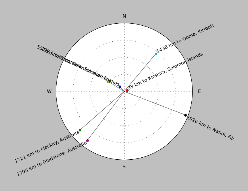
| ||||||||||||||||
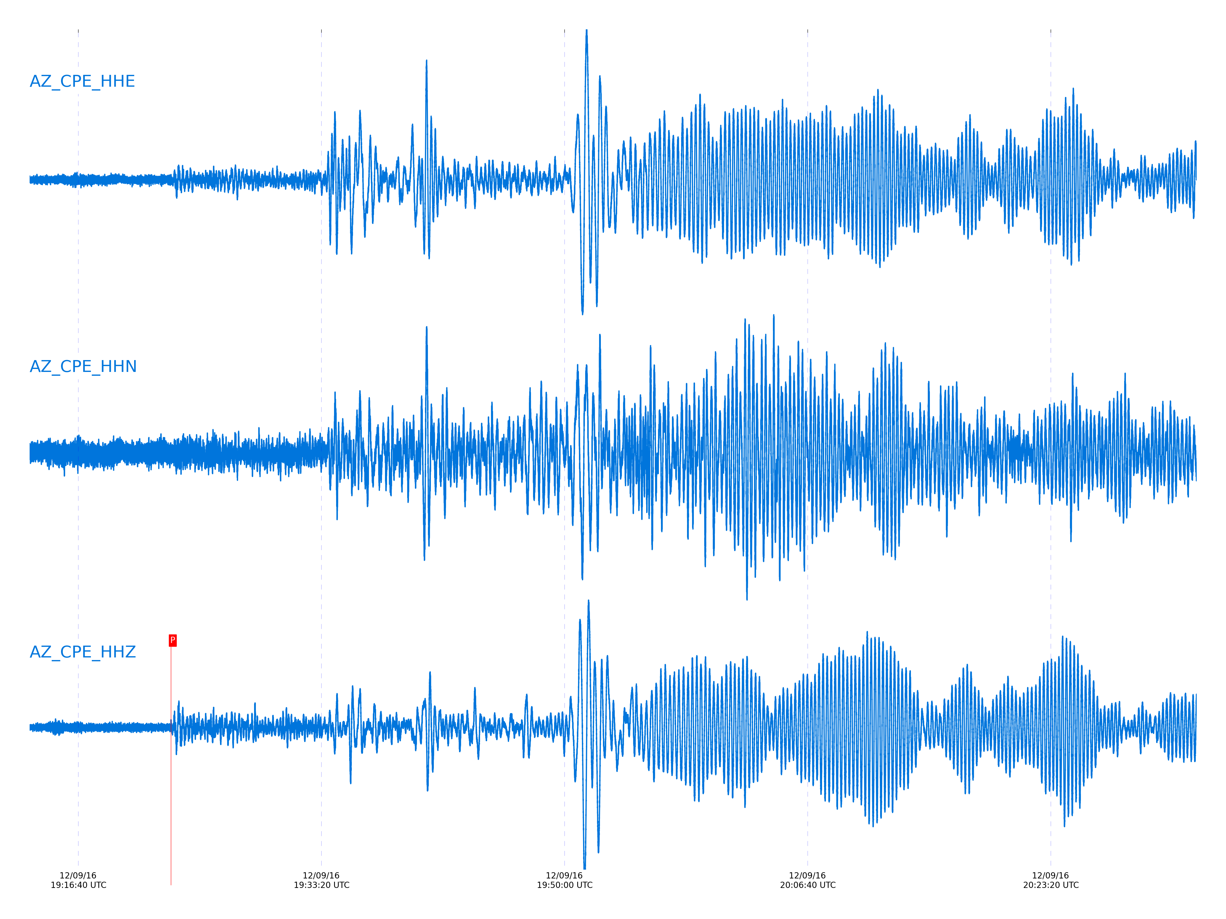
Event and active stations
|
|||||||||||||||||
Closest station with identified signal. Not filtered.
Subset of several stations close to the event. Not filtered.
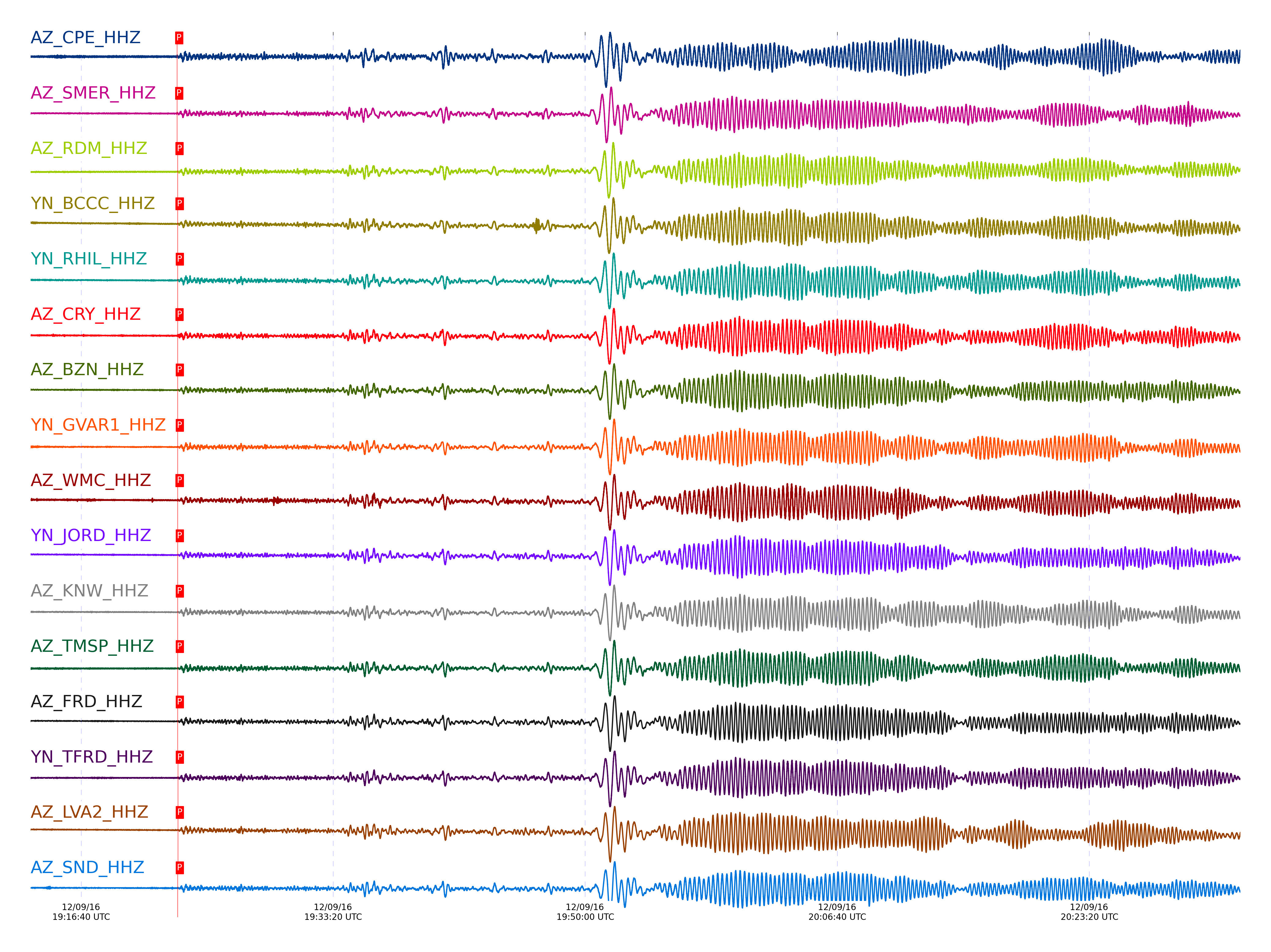
| STA_CHAN | S-E Delta | S-E Azimuth | Phase | Time | Signal/Noise | Time Residual | V. Model | Auth | arid |
|---|---|---|---|---|---|---|---|---|---|
| CPE_HHZ | 89.04° | 256.55° | P | 2016-12-09 19:23:00.778 UTC | -1 | 0.029 | iasp91 | dbp:jtytell:163 | 1289234 |
| SMER_HHZ | 89.119° | 256.51° | P | 2016-12-09 19:23:00.8654 UTC | 10.241 | -0.254 | iasp91 | dbp:jtytell:163 | 1289145 |
| RDM_HHZ | 89.421° | 256.68° | P | 2016-12-09 19:23:02.6329 UTC | -1 | 0.1 | iasp91 | dbp:jtytell:163 | 1289240 |
| BCCC_HHZ | 89.455° | 256.7° | P | 2016-12-09 19:23:03.0042 UTC | 11.803 | 0.313 | iasp91 | dbp:jtytell:163 | 1289148 |
| RHIL_HHZ | 89.493° | 256.73° | P | 2016-12-09 19:23:03.3941 UTC | -1 | 0.525 | iasp91 | dbp:jtytell:163 | 1289274 |
| CRY_HHZ | 89.496° | 256.75° | P | 2016-12-09 19:23:02.4159 UTC | 11.111 | -0.466 | iasp91 | dbp:jtytell:163 | 1289146 |
| RRSP_HHZ | 89.514° | 256.74° | P | 2016-12-09 19:23:03.2793 UTC | -1 | 0.313 | iasp91 | dbp:jtytell:163 | 1289243 |
| BZN_HHZ | 89.536° | 256.78° | P | 2016-12-09 19:23:03.2408 UTC | -1 | 0.171 | iasp91 | dbp:jtytell:163 | 1289244 |
| GVAR1_HHZ | 89.544° | 256.76° | P | 2016-12-09 19:23:03.2068 UTC | 11.63 | 0.1 | iasp91 | dbp:jtytell:163 | 1289154 |
| WMC_HHZ | 89.548° | 256.78° | P | 2016-12-09 19:23:03.0161 UTC | -1 | -0.112 | iasp91 | dbp:jtytell:163 | 1289246 |
| JORD_HHZ | 89.549° | 256.8° | P | 2016-12-09 19:23:03.5162 UTC | -1 | 0.383 | iasp91 | dbp:jtytell:163 | 1289248 |
| KNW_HHZ | 89.55° | 256.76° | P | 2016-12-09 19:23:03.1671 UTC | 12.802 | 0.029 | iasp91 | dbp:jtytell:163 | 1289152 |
| TMSP_HHZ | 89.554° | 256.78° | P | 2016-12-09 19:23:03.3955 UTC | -1 | 0.242 | iasp91 | dbp:jtytell:163 | 1289249 |
| FRD_HHZ | 89.589° | 256.82° | P | 2016-12-09 19:23:03.4902 UTC | -1 | 0.171 | iasp91 | dbp:jtytell:163 | 1289251 |
| TFRD_HHZ | 89.589° | 256.82° | P | 2016-12-09 19:23:03.6319 UTC | -1 | 0.313 | iasp91 | dbp:jtytell:163 | 1289277 |
| LVA2_HHZ | 89.59° | 256.84° | P | 2016-12-09 19:23:03.7756 UTC | -1 | 0.454 | iasp91 | dbp:jtytell:163 | 1289252 |
| SND_HHZ | 89.594° | 256.81° | P | 2016-12-09 19:23:03.5814 UTC | -1 | 0.242 | iasp91 | dbp:jtytell:163 | 1289253 |
| MONP2_HHZ | 89.599° | 256.92° | P | 2016-12-09 19:23:03.748 UTC | 12.522 | 0.383 | iasp91 | dbp:jtytell:163 | 1289150 |
| TR04_HHZ | 89.711° | 256.92° | P | 2016-12-09 19:23:04.1988 UTC | -1 | 0.313 | iasp91 | dbp:jtytell:163 | 1289256 |
| TR03_HHZ | 89.715° | 256.92° | P | 2016-12-09 19:23:04.1496 UTC | -1 | 0.242 | iasp91 | dbp:jtytell:163 | 1289257 |
| TR02_HHZ | 89.723° | 256.92° | P | 2016-12-09 19:23:04.0419 UTC | -1 | 0.1 | iasp91 | dbp:jtytell:163 | 1289258 |
| TR01_HHZ | 89.726° | 256.93° | P | 2016-12-09 19:23:04.1301 UTC | -1 | 0.171 | iasp91 | dbp:jtytell:163 | 1289259 |
| PFO_HHZ | 89.732° | 256.9° | P | 2016-12-09 19:23:04.0849 UTC | -1 | 0.1 | iasp91 | dbp:jtytell:163 | 1289262 |
| TRO_HHZ | 89.739° | 256.92° | P | 2016-12-09 19:23:04.5441 UTC | -1 | 0.525 | iasp91 | dbp:jtytell:163 | 1289282 |
Click the link below to observe an interactive map of earthquakes recorded by the station deployment:
Broadband Seismic Data Collection Center (ANZA),
Institute of Geophysics & Planetary Physics
Scripps Institution of Oceanography,
University of California San Diego
Copyright © 1989 - 2014. All Rights Reserved.