
last update to page: December 28 2016 21:26:00 (UTC).
SummaryThe red marker denotes the earthquake epicenter. On Wed Dec 28th 2016 09:13:47 (UTC) the seismic network recorded an earthquake (preliminary 5.5 ml) located in California-nevada Border Region. Seismic region California - Nevada Region. The epicentral distance (i.e. distance separating the location to the epicenter) to the closest station CSLB in the network is 516.5 km. If you felt the quake, the USGS would like to know. Please add your comments to the USGS page "Did you feel it?". |
Details
Proximity to Population Centers
| ||||||||||||||||
Event and active stations
|
|||||||||||||||||
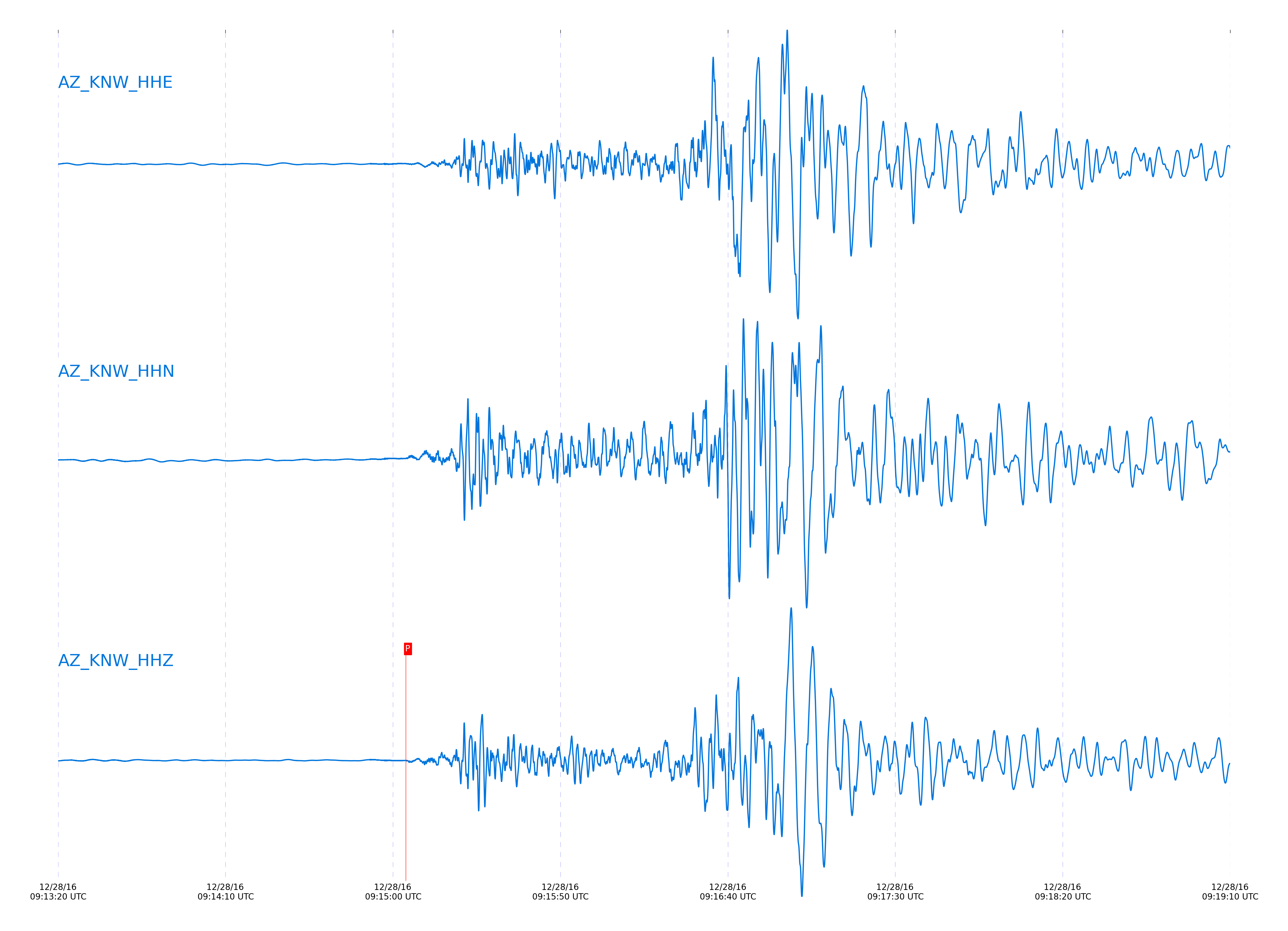
Closest station with identified signal. Not filtered.
Subset of several stations close to the event. Not filtered.
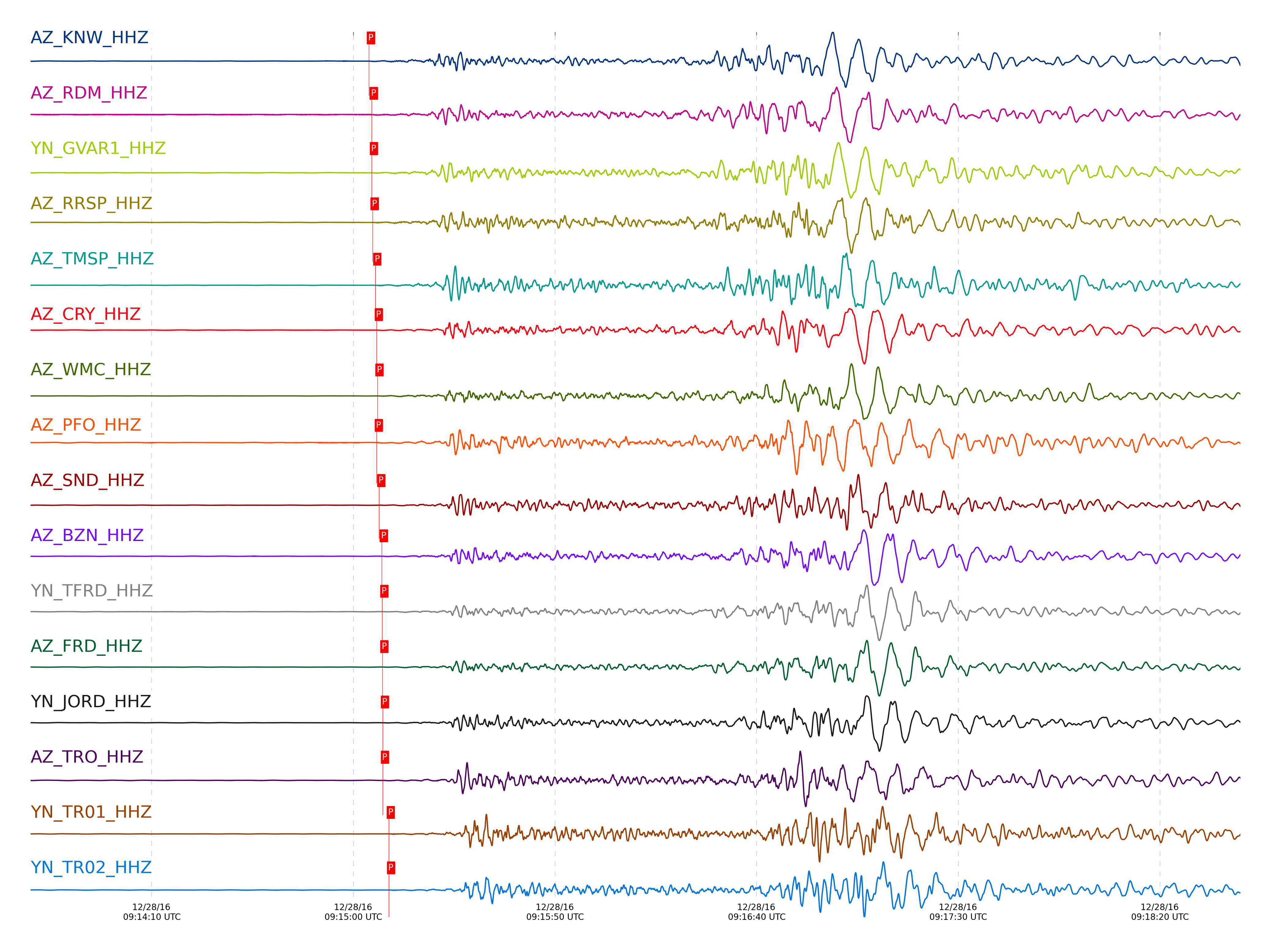
| STA_CHAN | S-E Delta | S-E Azimuth | Phase | Time | Signal/Noise | Time Residual | V. Model | Auth | arid |
|---|---|---|---|---|---|---|---|---|---|
| KNW_HHZ | 4.985° | 339.89° | pPn | 2016-12-28 09:15:03.8683 UTC | 124.69 | -0.477 | iasp91 | dbp:jtytell:163 | 1306421 |
| RDM_HHZ | 5.027° | 341.35° | pPn | 2016-12-28 09:15:04.5549 UTC | 91.204 | -0.365 | iasp91 | dbp:jtytell:163 | 1306424 |
| GVAR1_HHZ | 5.032° | 340.03° | pPn | 2016-12-28 09:15:04.5902 UTC | 16.241 | -0.393 | iasp91 | dbp:jtytell:163 | 1306388 |
| RRSP_HHZ | 5.036° | 340.36° | pPn | 2016-12-28 09:15:04.7944 UTC | -1 | -0.253 | iasp91 | dbp:jtytell:163 | 1307064 |
| TMSP_HHZ | 5.083° | 340° | pPn | 2016-12-28 09:15:05.4389 UTC | -1 | -0.253 | iasp91 | dbp:jtytell:163 | 1307065 |
| CRY_HHZ | 5.118° | 340.67° | pPn | 2016-12-28 09:15:05.8059 UTC | 85.147 | -0.365 | iasp91 | dbp:jtytell:163 | 1306426 |
| WMC_HHZ | 5.128° | 340.13° | pPn | 2016-12-28 09:15:05.9682 UTC | 9.009 | -0.337 | iasp91 | dbp:jtytell:163 | 1306389 |
| PFO_HHZ | 5.156° | 338.23° | pPn | 2016-12-28 09:15:05.7951 UTC | -1 | -0.897 | iasp91 | dbp:jtytell:163 | 1307068 |
| SND_HHZ | 5.166° | 339.71° | pPn | 2016-12-28 09:15:06.4073 UTC | 8.5851 | -0.421 | iasp91 | dbp:jtytell:163 | 1306392 |
| BZN_HHZ | 5.207° | 340.37° | pPn | 2016-12-28 09:15:07.0598 UTC | 7.9414 | -0.337 | iasp91 | dbp:jtytell:163 | 1306391 |
| TFRD_HHZ | 5.223° | 339.84° | pPn | 2016-12-28 09:15:07.1579 UTC | -1 | -0.449 | iasp91 | dbp:jtytell:163 | 1307096 |
| FRD_HHZ | 5.223° | 339.84° | pPn | 2016-12-28 09:15:07.1872 UTC | 22.345 | -0.421 | iasp91 | dbp:jtytell:163 | 1306390 |
| JORD_HHZ | 5.232° | 340.26° | pPn | 2016-12-28 09:15:07.3105 UTC | 6.7513 | -0.421 | iasp91 | dbp:jtytell:163 | 1306393 |
| TRO_HHZ | 5.248° | 338.32° | pPn | 2016-12-28 09:15:07.317 UTC | 10.615 | -0.645 | iasp91 | dbp:jtytell:163 | 1306394 |
| TR01_HHZ | 5.346° | 338.63° | pPn | 2016-12-28 09:15:08.7929 UTC | 54.881 | -0.505 | iasp91 | dbp:jtytell:163 | 1306397 |
| TR02_HHZ | 5.349° | 338.67° | pPn | 2016-12-28 09:15:08.838 UTC | -1 | -0.505 | iasp91 | dbp:jtytell:163 | 1307102 |
| TR03_HHZ | 5.355° | 338.75° | pPn | 2016-12-28 09:15:08.8676 UTC | -1 | -0.561 | iasp91 | dbp:jtytell:163 | 1307103 |
| TR04_HHZ | 5.364° | 338.82° | pPn | 2016-12-28 09:15:09.0774 UTC | -1 | -0.477 | iasp91 | dbp:jtytell:163 | 1307104 |
| LVA2_HHZ | 5.369° | 340.05° | pPn | 2016-12-28 09:15:09.2783 UTC | 16.258 | -0.337 | iasp91 | dbp:jtytell:163 | 1306398 |
| CPE_HHZ | 5.677° | 345.66° | pPn | 2016-12-28 09:15:13.5704 UTC | 54.043 | -0.281 | iasp91 | dbp:jtytell:163 | 1306437 |
| MONP2_HHZ | 5.841° | 340.58° | pPn | 2016-12-28 09:15:15.5953 UTC | -1 | -0.506 | iasp91 | dbp:jtytell:163 | 1307113 |
Click the link below to observe an interactive map of earthquakes recorded by the station deployment:
Broadband Seismic Data Collection Center (ANZA),
Institute of Geophysics & Planetary Physics
Scripps Institution of Oceanography,
University of California San Diego
Copyright © 1989 - 2014. All Rights Reserved.