
last update to page: March 27 2017 17:27:27 (UTC).
SummaryThe red marker denotes the earthquake epicenter. On Mon Mar 27th 2017 10:50:19 (UTC) the seismic network recorded an earthquake (preliminary 6.1 mww) located in Near Islands, Aleutian Islands. Seismic region Alaska - Aleutian Arc. The epicentral distance (i.e. distance separating the location to the epicenter) to the closest station CSLB in the network is 5,775.3 km. If you felt the quake, the USGS would like to know. Please add your comments to the USGS page "Did you feel it?". |
Details
Proximity to Population Centers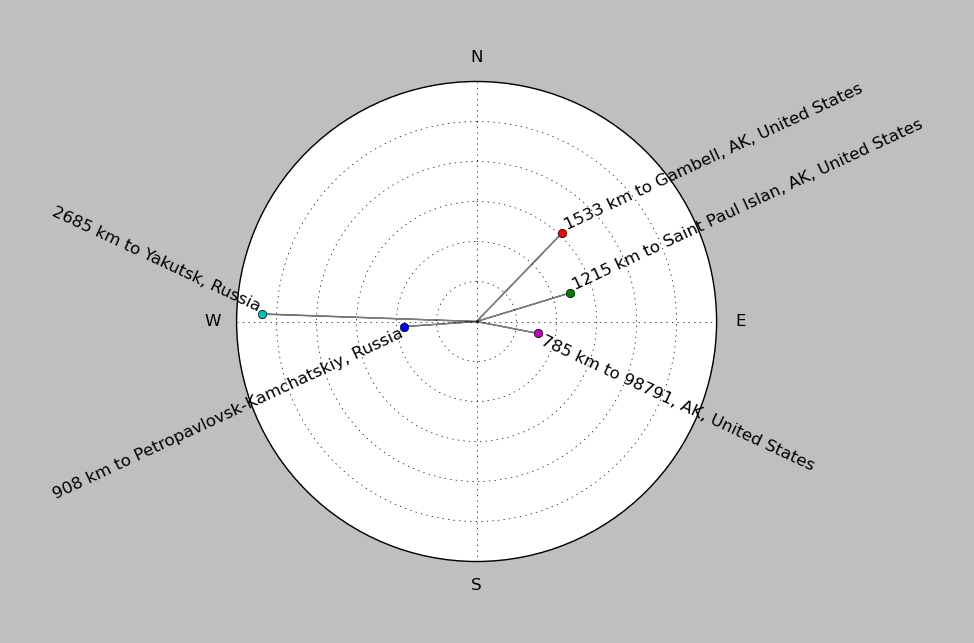
| ||||||||||||||||
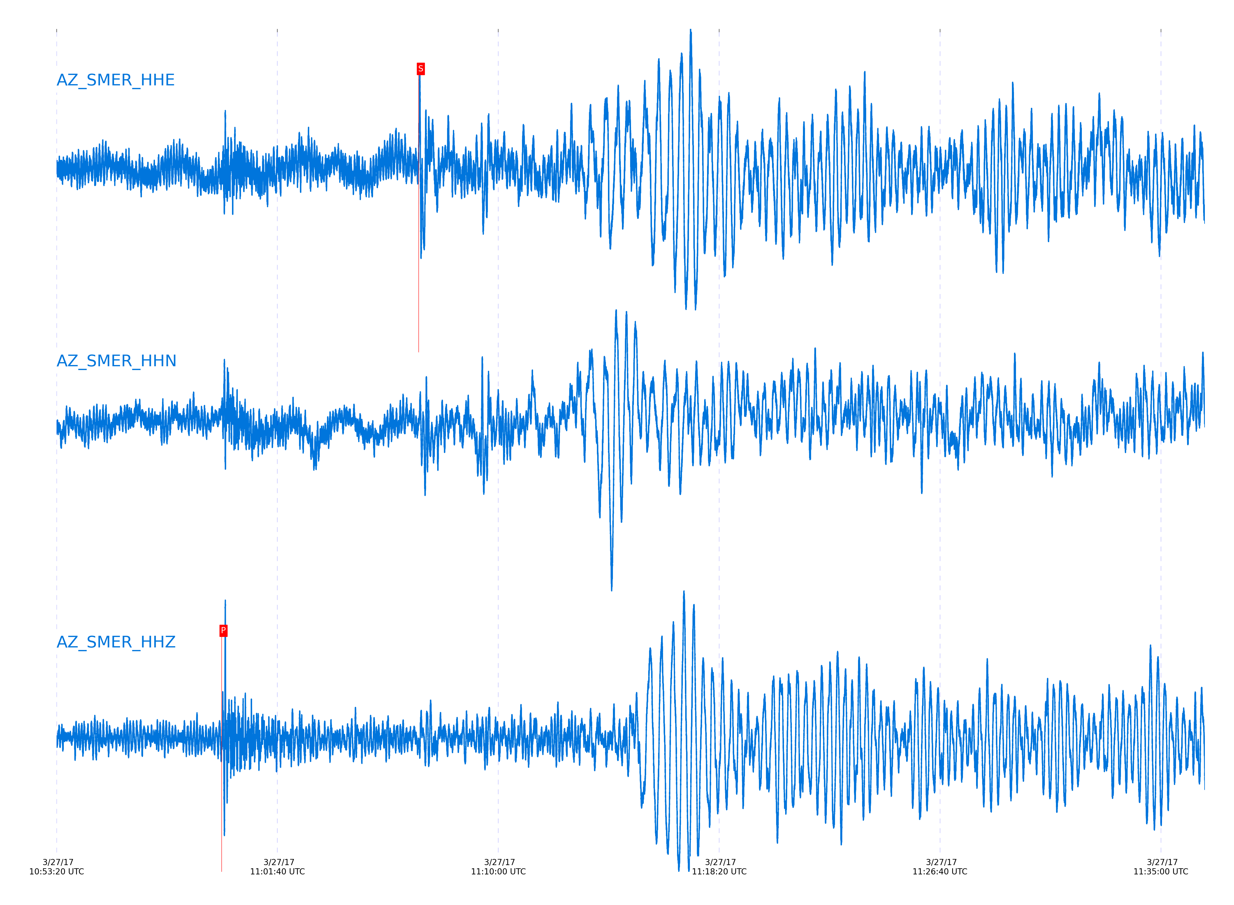
Event and active stations
|
|||||||||||||||||
Closest station with identified signal. Not filtered.
Subset of several stations close to the event. Not filtered.
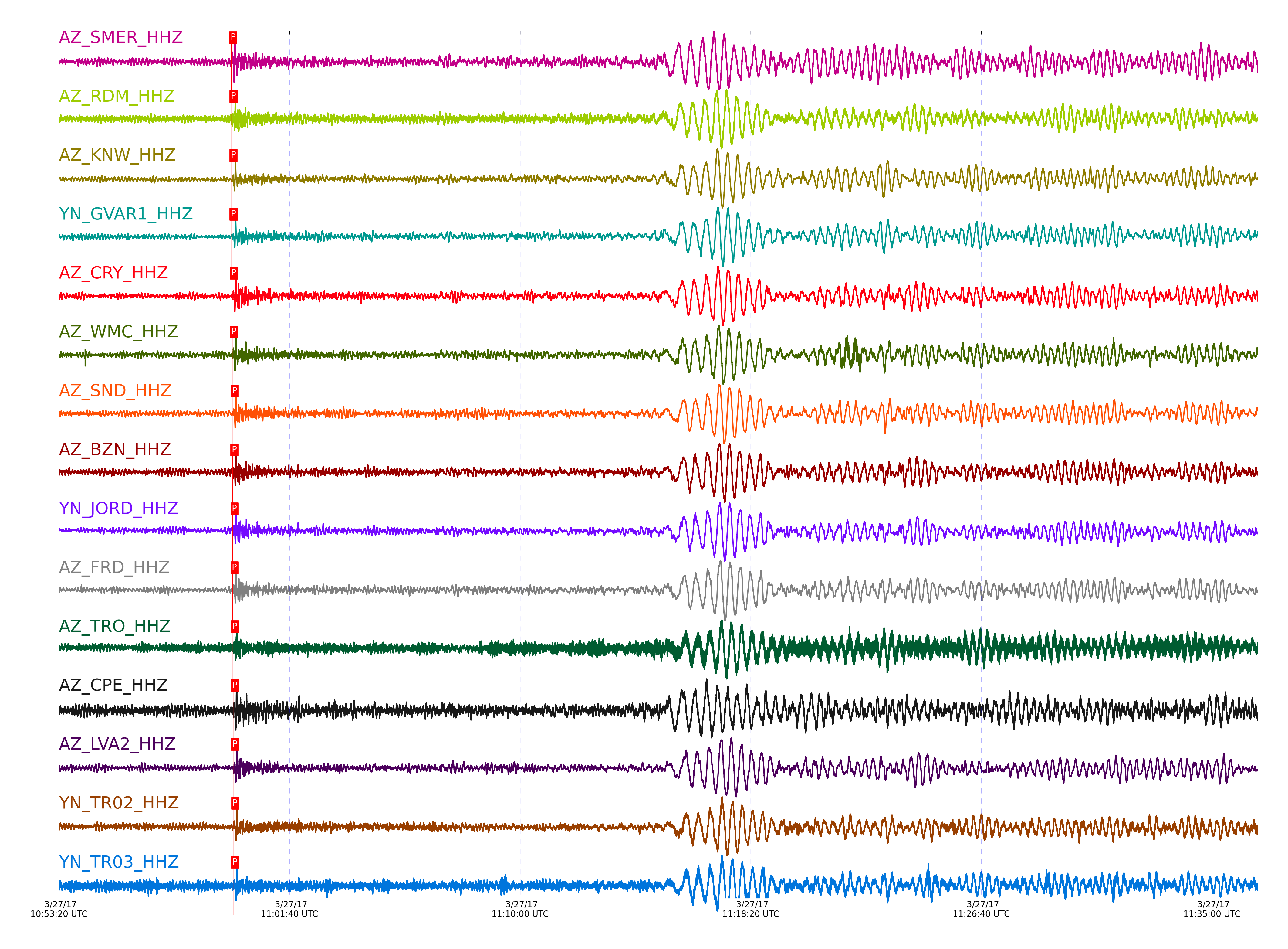
| STA_CHAN | S-E Delta | S-E Azimuth | Phase | Time | Signal/Noise | Time Residual | V. Model | Auth | arid |
|---|---|---|---|---|---|---|---|---|---|
| SMER_HHZ | 52.668° | 314.16° | P | 2017-03-27 10:59:33.6889 UTC | -1 | 0.099 | iasp91 | dbp:jtytell:170 | 1365245 |
| SMER_HHE | 52.668° | 314.16° | S | 2017-03-27 11:06:59.8486 UTC | -1 | -2.109 | iasp91 | dbp:jtytell:170 | 1365283 |
| RDM_HHZ | 52.741° | 314.1° | P | 2017-03-27 10:59:34.579 UTC | 24.514 | 0.447 | iasp91 | dbp:jtytell:170 | 1365112 |
| RDM_HHE | 52.741° | 314.1° | S | 2017-03-27 11:07:00.7802 UTC | -1 | -2.179 | iasp91 | dbp:jtytell:170 | 1365284 |
| RHIL_HHE | 52.757° | 314.09° | S | 2017-03-27 11:07:01.4153 UTC | -1 | -1.758 | iasp91 | dbp:jtytell:170 | 1365285 |
| KNW_HHZ | 52.764° | 314.07° | P | 2017-03-27 10:59:34.4987 UTC | 13.071 | 0.199 | iasp91 | dbp:jtytell:170 | 1365114 |
| GVAR1_HHZ | 52.8° | 314.1° | P | 2017-03-27 10:59:34.6191 UTC | -1 | 0.05 | iasp91 | dbp:jtytell:170 | 1365251 |
| CRY_HHZ | 52.852° | 314.15° | P | 2017-03-27 10:59:35.5495 UTC | 19.956 | 0.596 | iasp91 | dbp:jtytell:170 | 1365116 |
| CRY_HHE | 52.852° | 314.15° | S | 2017-03-27 11:07:01.9909 UTC | -1 | -2.485 | iasp91 | dbp:jtytell:170 | 1365288 |
| WMC_HHZ | 52.884° | 314.15° | P | 2017-03-27 10:59:35.7343 UTC | 13.889 | 0.547 | iasp91 | dbp:jtytell:170 | 1365119 |
| WMC_HHE | 52.884° | 314.15° | S | 2017-03-27 11:07:01.9658 UTC | -1 | -2.943 | iasp91 | dbp:jtytell:170 | 1365289 |
| SND_HHZ | 52.936° | 314.17° | P | 2017-03-27 10:59:36.9637 UTC | -1 | 1.391 | iasp91 | dbp:jtytell:170 | 1365258 |
| BZN_HHZ | 52.945° | 314.2° | P | 2017-03-27 10:59:36.6382 UTC | 21.588 | 0.994 | iasp91 | dbp:jtytell:170 | 1365118 |
| JORD_HHZ | 52.972° | 314.21° | P | 2017-03-27 10:59:36.7354 UTC | -1 | 0.894 | iasp91 | dbp:jtytell:170 | 1365259 |
| JORD_HHE | 52.972° | 314.21° | S | 2017-03-27 11:07:03.5275 UTC | -1 | -2.587 | iasp91 | dbp:jtytell:170 | 1365292 |
| TFRD_HHE | 52.982° | 314.2° | S | 2017-03-27 11:07:04.249 UTC | -1 | -2 | iasp91 | dbp:jtytell:170 | 1365293 |
| FRD_HHZ | 52.982° | 314.2° | P | 2017-03-27 10:59:36.8582 UTC | 12.783 | 0.944 | iasp91 | dbp:jtytell:170 | 1365123 |
| FRD_HHE | 52.982° | 314.2° | S | 2017-03-27 11:07:04.3793 UTC | -1 | -1.871 | iasp91 | dbp:jtytell:170 | 1365294 |
| PFO_HHE | 52.986° | 314.16° | S | 2017-03-27 11:07:03.7585 UTC | -1 | -2.543 | iasp91 | dbp:jtytell:170 | 1365296 |
| TRO_HHZ | 53.067° | 314.21° | P | 2017-03-27 10:59:37.5388 UTC | 13.171 | 0.994 | iasp91 | dbp:jtytell:170 | 1365133 |
| CPE_HHZ | 53.104° | 314.48° | P | 2017-03-27 10:59:37.6623 UTC | 10.364 | 0.845 | iasp91 | dbp:jtytell:170 | 1365127 |
| CPE_HHE | 53.104° | 314.48° | S | 2017-03-27 11:07:04.6339 UTC | -1 | -3.285 | iasp91 | dbp:jtytell:170 | 1365301 |
| LVA2_HHZ | 53.106° | 314.29° | P | 2017-03-27 10:59:37.6255 UTC | 15.961 | 0.795 | iasp91 | dbp:jtytell:170 | 1365129 |
| LVA2_HHE | 53.106° | 314.29° | S | 2017-03-27 11:07:06.7231 UTC | -1 | -1.219 | iasp91 | dbp:jtytell:170 | 1365302 |
| TR02_HHZ | 53.146° | 314.27° | P | 2017-03-27 10:59:38.0194 UTC | -1 | 0.894 | iasp91 | dbp:jtytell:170 | 1365269 |
| TR03_HHZ | 53.148° | 314.27° | P | 2017-03-27 10:59:37.9367 UTC | -1 | 0.795 | iasp91 | dbp:jtytell:170 | 1365270 |
| MONP2_HHE | 53.511° | 314.55° | S | 2017-03-27 11:07:12.8182 UTC | -1 | -0.632 | iasp91 | dbp:jtytell:170 | 1365308 |
Click the link below to observe an interactive map of earthquakes recorded by the station deployment:
Broadband Seismic Data Collection Center (ANZA),
Institute of Geophysics & Planetary Physics
Scripps Institution of Oceanography,
University of California San Diego
Copyright © 1989 - 2014. All Rights Reserved.