
last update to page: March 29 2017 21:56:01 (UTC).
SummaryThe red marker denotes the earthquake epicenter. On Wed Mar 29th 2017 15:15:26 (UTC) the seismic network recorded an earthquake (preliminary 5.7 mww) located in Gulf Of California. Seismic region Baja California And Gulf Of California. The epicentral distance (i.e. distance separating the location to the epicenter) to the closest station USGCB in the network is 978.4 km. If you felt the quake, the USGS would like to know. Please add your comments to the USGS page "Did you feel it?". |
Details
Proximity to Population Centers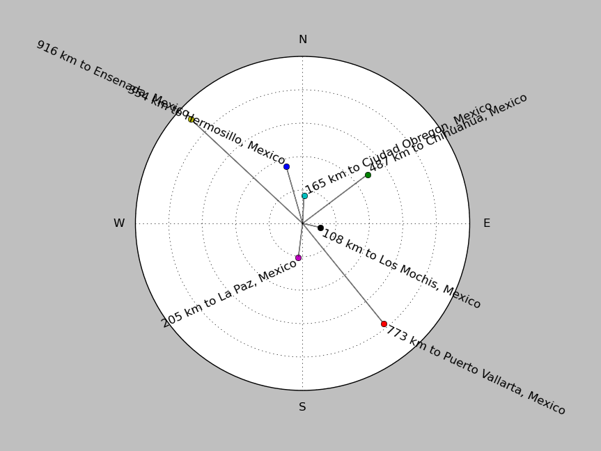
| ||||||||||||||||
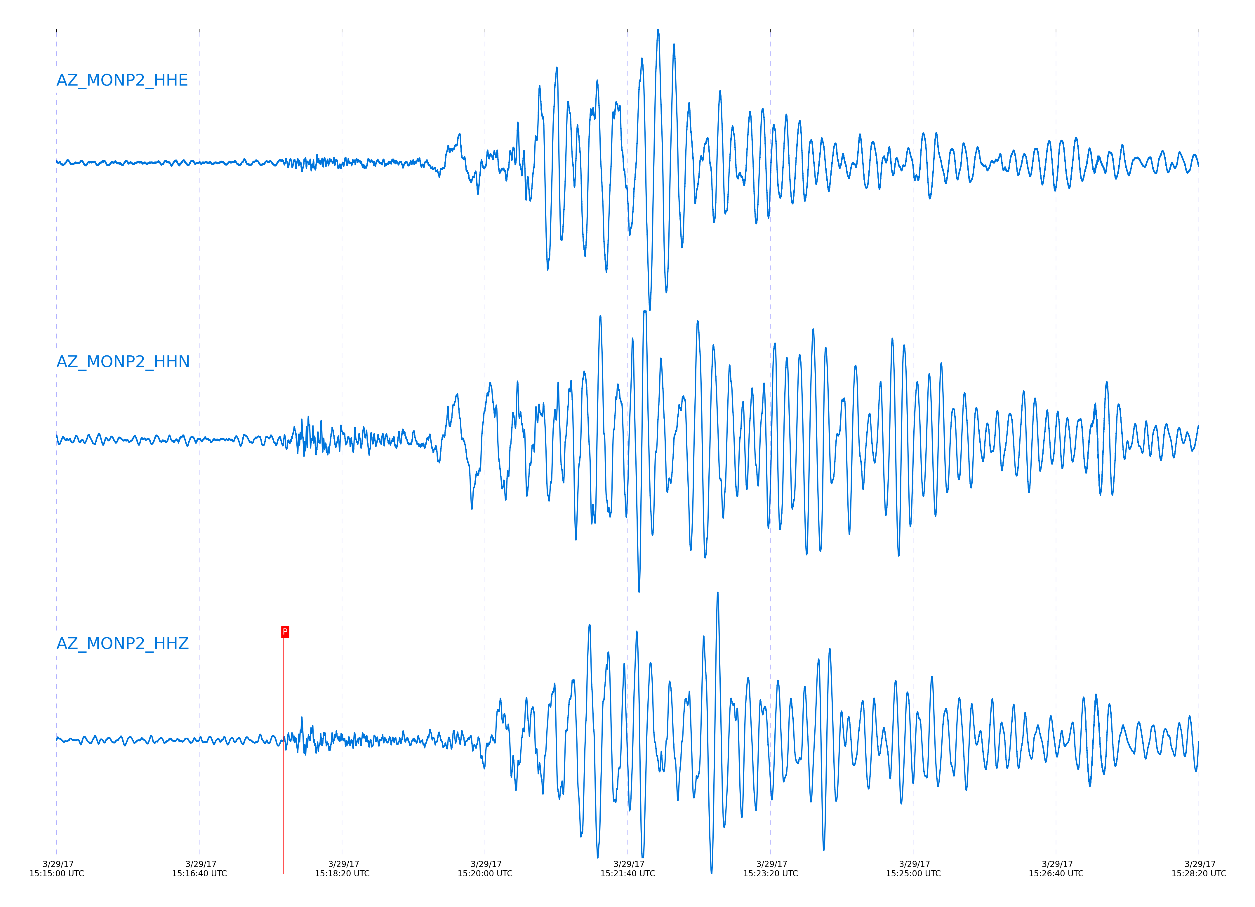
Event and active stations
|
|||||||||||||||||
Closest station with identified signal. Not filtered.
Subset of several stations close to the event. Not filtered.
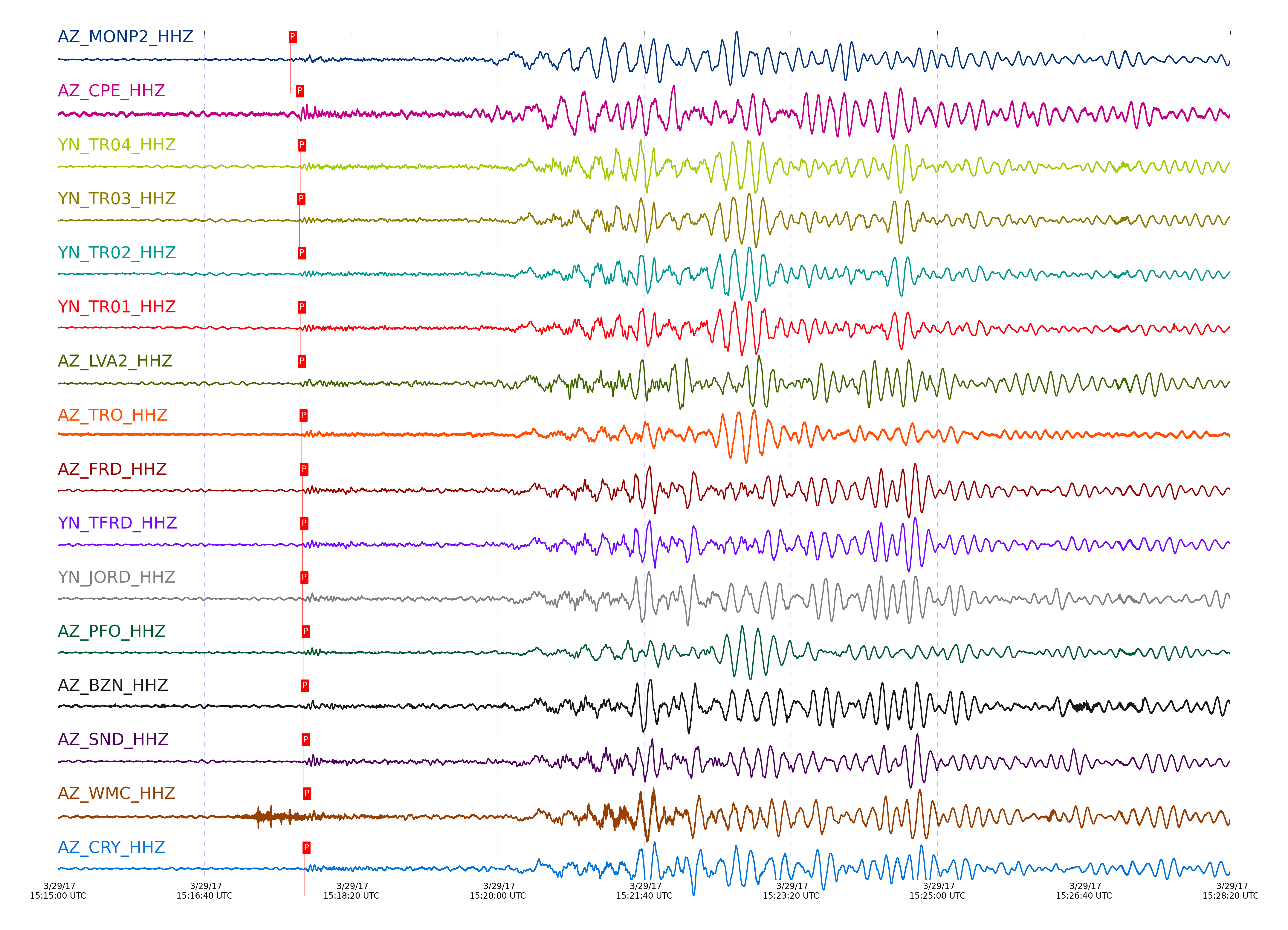
| STA_CHAN | S-E Delta | S-E Azimuth | Phase | Time | Signal/Noise | Time Residual | V. Model | Auth | arid |
|---|---|---|---|---|---|---|---|---|---|
| MONP2_HHZ | 8.863° | 139.44° | pPn | 2017-03-29 15:17:38.8062 UTC | 16.614 | 1.617 | iasp91 | dbp:jtytell:170 | 1367227 |
| CPE_HHZ | 9.245° | 136.38° | pPn | 2017-03-29 15:17:43.6477 UTC | 17.642 | 1.219 | iasp91 | dbp:jtytell:170 | 1367231 |
| TR04_HHZ | 9.255° | 141.44° | PnPn | 2017-03-29 15:17:45.3835 UTC | -1 | -2.409 | iasp91 | dbp:jtytell:170 | 1367506 |
| TR03_HHZ | 9.262° | 141.5° | pPn | 2017-03-29 15:17:44.6839 UTC | -1 | 2.014 | iasp91 | dbp:jtytell:170 | 1367508 |
| TR02_HHZ | 9.266° | 141.56° | pPn | 2017-03-29 15:17:45.1793 UTC | -1 | 2.461 | iasp91 | dbp:jtytell:170 | 1367509 |
| TR01_HHZ | 9.268° | 141.59° | pPn | 2017-03-29 15:17:45.2053 UTC | -1 | 2.461 | iasp91 | dbp:jtytell:170 | 1367512 |
| LVA2_HHZ | 9.29° | 140.65° | pPn | 2017-03-29 15:17:45.1101 UTC | 15.296 | 2.063 | iasp91 | dbp:jtytell:170 | 1367229 |
| TRO_HHZ | 9.353° | 141.92° | pPn | 2017-03-29 15:17:46.2244 UTC | 15.66 | 2.312 | iasp91 | dbp:jtytell:170 | 1367235 |
| FRD_HHZ | 9.422° | 141.02° | pPn | 2017-03-29 15:17:46.7262 UTC | -1 | 1.864 | iasp91 | dbp:jtytell:170 | 1367514 |
| TFRD_HHZ | 9.422° | 141.02° | pPn | 2017-03-29 15:17:46.7272 UTC | -1 | 1.864 | iasp91 | dbp:jtytell:170 | 1367515 |
| JORD_HHZ | 9.427° | 140.74° | pPn | 2017-03-29 15:17:46.7957 UTC | -1 | 1.864 | iasp91 | dbp:jtytell:170 | 1367517 |
| PFO_HHZ | 9.44° | 142.09° | pPn | 2017-03-29 15:17:47.7133 UTC | 33.67 | 2.61 | iasp91 | dbp:jtytell:170 | 1367239 |
| BZN_HHZ | 9.454° | 140.72° | pPn | 2017-03-29 15:17:47.1099 UTC | 14.927 | 1.815 | iasp91 | dbp:jtytell:170 | 1367233 |
| SND_HHZ | 9.472° | 141.18° | pPn | 2017-03-29 15:17:47.7112 UTC | -1 | 2.162 | iasp91 | dbp:jtytell:170 | 1367524 |
| WMC_HHZ | 9.522° | 140.99° | pPn | 2017-03-29 15:17:48.5847 UTC | 22.432 | 2.361 | iasp91 | dbp:jtytell:170 | 1367241 |
| CRY_HHZ | 9.548° | 140.68° | pPn | 2017-03-29 15:17:48.303 UTC | 23.215 | 1.715 | iasp91 | dbp:jtytell:170 | 1367242 |
| GVAR1_HHZ | 9.61° | 141.2° | pPn | 2017-03-29 15:17:49.4044 UTC | -1 | 1.963 | iasp91 | dbp:jtytell:170 | 1367527 |
| RRSP_HHZ | 9.616° | 141° | pPn | 2017-03-29 15:17:49.5809 UTC | -1 | 2.063 | iasp91 | dbp:jtytell:170 | 1367528 |
| RHIL_HHZ | 9.65° | 140.94° | pPn | 2017-03-29 15:17:50.041 UTC | -1 | 2.063 | iasp91 | dbp:jtytell:170 | 1367530 |
| KNW_HHZ | 9.65° | 141.35° | pPn | 2017-03-29 15:17:49.9532 UTC | 27.63 | 1.963 | iasp91 | dbp:jtytell:170 | 1367244 |
| RDM_HHZ | 9.656° | 140.45° | pPn | 2017-03-29 15:17:49.7383 UTC | 23.869 | 1.665 | iasp91 | dbp:jtytell:170 | 1367243 |
Click the link below to observe an interactive map of earthquakes recorded by the station deployment:
Broadband Seismic Data Collection Center (ANZA),
Institute of Geophysics & Planetary Physics
Scripps Institution of Oceanography,
University of California San Diego
Copyright © 1989 - 2014. All Rights Reserved.