
last update to page: April 03 2017 23:22:38 (UTC).
SummaryThe red marker denotes the earthquake epicenter. On Sat Apr 1st 2017 06:40:44 (UTC) the seismic network recorded an earthquake (preliminary 3.62 ml) located in Calif.-baja Calif. Border Region. Seismic region California - Nevada Region. The epicentral distance (i.e. distance separating the location to the epicenter) to the closest station CPE in the network is 39.7 km. If you felt the quake, the USGS would like to know. Please add your comments to the USGS page "Did you feel it?". |
Details
Proximity to Population Centers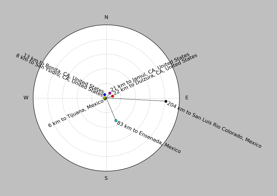
| ||||||||||||||||
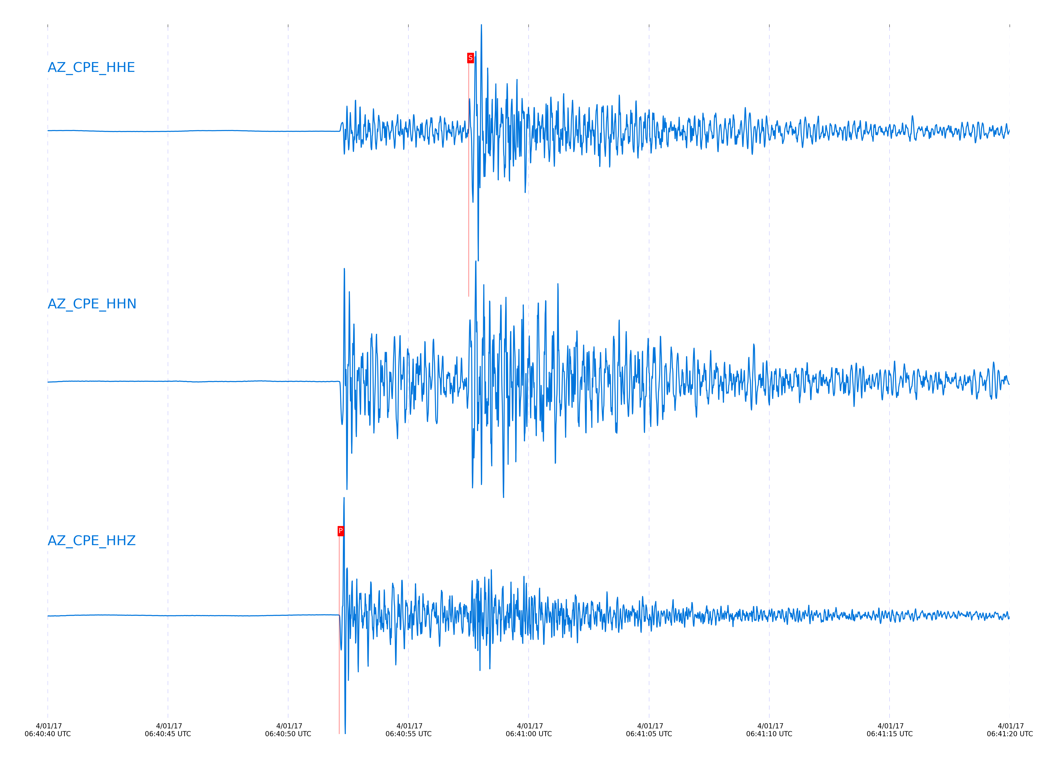
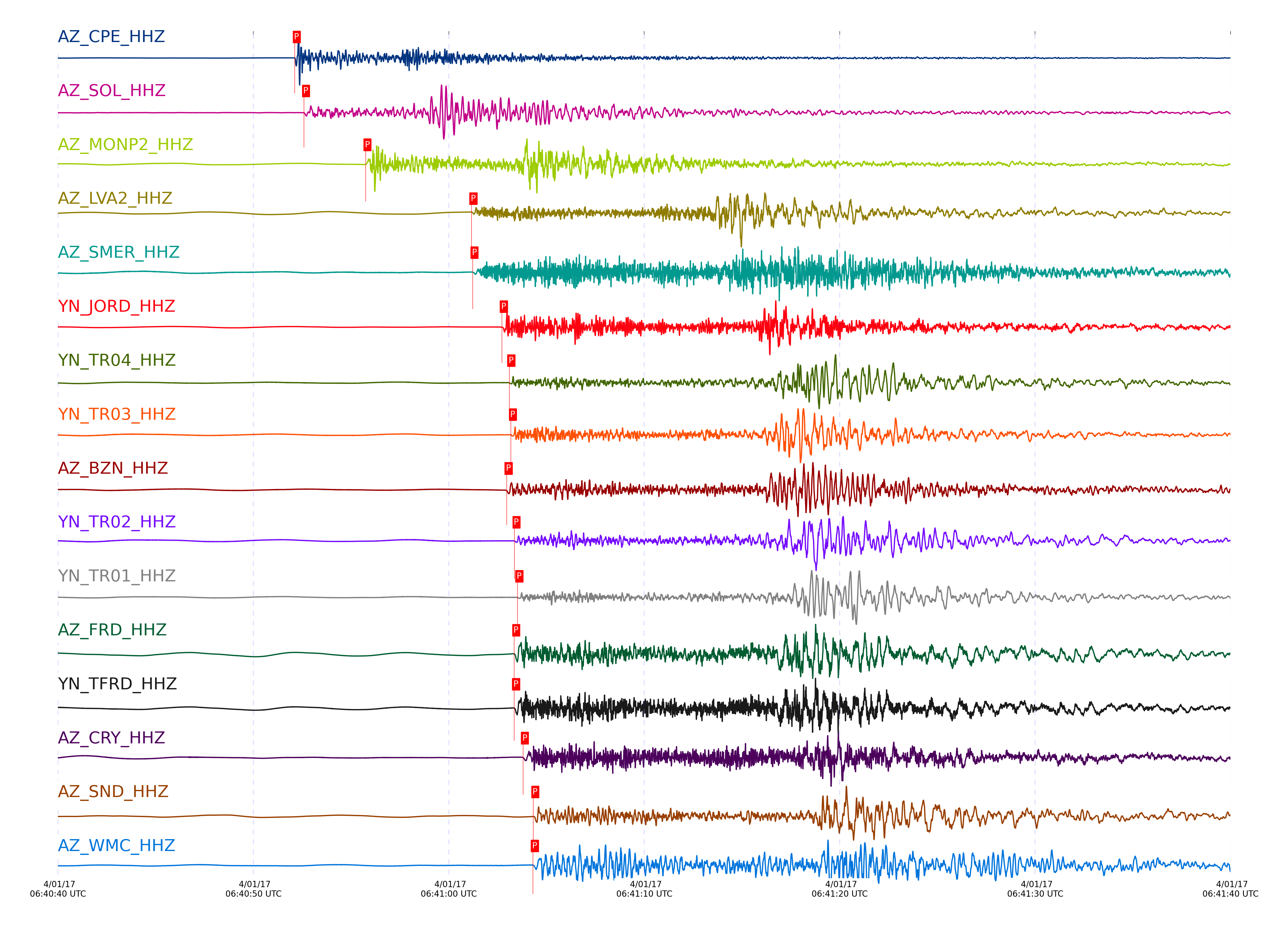
Event and active stations
|
|||||||||||||||||
Closest station with identified signal. Not filtered.
Subset of several stations close to the event. Not filtered.
| STA_CHAN | S-E Delta | S-E Azimuth | Phase | Time | Signal/Noise | Time Residual | V. Model | Auth | arid |
|---|---|---|---|---|---|---|---|---|---|
| CPE_HHZ | 0.357° | 159.41° | P | 2017-04-01 06:40:52.1251 UTC | 807.35 | 0.246 | iasp91 | dbp:jtytell:170 | 1369182 |
| CPE_HHE | 0.357° | 159.41° | S | 2017-04-01 06:40:57.5121 UTC | -1 | 0.32 | iasp91 | dbp:jtytell:170 | 1370256 |
| SOL_HHZ | 0.377° | 139.27° | P | 2017-04-01 06:40:52.5975 UTC | 49.742 | 0.345 | iasp91 | dbp:jtytell:170 | 1369184 |
| MONP2_HHZ | 0.562° | 233.3° | P | 2017-04-01 06:40:55.7449 UTC | 40.983 | -0.067 | iasp91 | dbp:jtytell:170 | 1369209 |
| MONP2_HHN | 0.562° | 233.3° | S | 2017-04-01 06:41:03.8655 UTC | -1 | -0.19 | iasp91 | dbp:jtytell:170 | 1370241 |
| LVA2_HHZ | 0.863° | 202.7° | P | 2017-04-01 06:41:01.1631 UTC | 331.05 | -0.161 | iasp91 | dbp:jtytell:170 | 1369188 |
| LVA2_HHN | 0.863° | 202.7° | S | 2017-04-01 06:41:13.4106 UTC | -1 | -0.179 | iasp91 | dbp:jtytell:170 | 1370247 |
| SMER_HHZ | 0.92° | 168.68° | P | 2017-04-01 06:41:01.2201 UTC | 60.971 | -0.963 | iasp91 | dbp:jtytell:170 | 1369190 |
| JORD_HHZ | 0.954° | 195.98° | P | 2017-04-01 06:41:02.7195 UTC | -1 | -0.144 | iasp91 | dbp:jtytell:170 | 1370198 |
| JORD_HHE | 0.954° | 195.98° | S | 2017-04-01 06:41:15.8918 UTC | -1 | -0.371 | iasp91 | dbp:jtytell:170 | 1370252 |
| TR04_HHZ | 0.954° | 207.96° | P | 2017-04-01 06:41:03.1006 UTC | -1 | 0.291 | iasp91 | dbp:jtytell:170 | 1370197 |
| TR04_HHE | 0.954° | 207.96° | S | 2017-04-01 06:41:16.7541 UTC | -1 | 0.592 | iasp91 | dbp:jtytell:170 | 1370251 |
| TR03_HHZ | 0.964° | 207.78° | P | 2017-04-01 06:41:03.1802 UTC | -1 | 0.196 | iasp91 | dbp:jtytell:170 | 1370199 |
| TR03_HHE | 0.964° | 207.78° | S | 2017-04-01 06:41:16.9044 UTC | -1 | 0.44 | iasp91 | dbp:jtytell:170 | 1370253 |
| BZN_HHZ | 0.967° | 194.61° | P | 2017-04-01 06:41:02.9617 UTC | 61.356 | -0.145 | iasp91 | dbp:jtytell:170 | 1369192 |
| BZN_HHN | 0.967° | 194.61° | S | 2017-04-01 06:41:16.3094 UTC | -1 | -0.377 | iasp91 | dbp:jtytell:170 | 1370254 |
| TR02_HHZ | 0.975° | 207.82° | P | 2017-04-01 06:41:03.3675 UTC | -1 | 0.204 | iasp91 | dbp:jtytell:170 | 1370200 |
| TR01_HHZ | 0.98° | 207.84° | P | 2017-04-01 06:41:03.5123 UTC | -1 | 0.257 | iasp91 | dbp:jtytell:170 | 1370203 |
| TR01_HHE | 0.98° | 207.84° | S | 2017-04-01 06:41:17.2949 UTC | -1 | 0.359 | iasp91 | dbp:jtytell:170 | 1370255 |
| FRD_HHZ | 0.985° | 197.64° | P | 2017-04-01 06:41:03.3484 UTC | 279.59 | -0.049 | iasp91 | dbp:jtytell:170 | 1369194 |
| FRD_HHE | 0.985° | 197.64° | S | 2017-04-01 06:41:16.9989 UTC | -1 | -0.189 | iasp91 | dbp:jtytell:170 | 1370258 |
| TFRD_HHZ | 0.986° | 197.64° | P | 2017-04-01 06:41:03.346 UTC | -1 | -0.032 | iasp91 | dbp:jtytell:170 | 1370202 |
| TFRD_HHE | 0.986° | 197.64° | S | 2017-04-01 06:41:16.9734 UTC | -1 | -0.178 | iasp91 | dbp:jtytell:170 | 1370259 |
| CRY_HHZ | 1.027° | 190.36° | P | 2017-04-01 06:41:03.7965 UTC | 96.053 | -0.303 | iasp91 | dbp:jtytell:170 | 1369196 |
| CRY_HHE | 1.027° | 190.36° | S | 2017-04-01 06:41:18.3977 UTC | -1 | -0.006 | iasp91 | dbp:jtytell:170 | 1370263 |
| SND_HHZ | 1.038° | 196.21° | P | 2017-04-01 06:41:04.3284 UTC | 282.73 | 0.018 | iasp91 | dbp:jtytell:170 | 1369198 |
| SND_HHN | 1.038° | 196.21° | S | 2017-04-01 06:41:18.7262 UTC | -1 | -0.049 | iasp91 | dbp:jtytell:170 | 1370264 |
| WMC_HHZ | 1.046° | 193.13° | P | 2017-04-01 06:41:04.3063 UTC | 124.64 | -0.129 | iasp91 | dbp:jtytell:170 | 1369200 |
| WMC_HHN | 1.046° | 193.13° | S | 2017-04-01 06:41:18.7461 UTC | -1 | -0.243 | iasp91 | dbp:jtytell:170 | 1370268 |
| TRO_HHZ | 1.066° | 204.83° | P | 2017-04-01 06:41:05.161 UTC | 9.6813 | 0.209 | iasp91 | dbp:jtytell:170 | 1369204 |
| TRO_HHN | 1.066° | 204.83° | S | 2017-04-01 06:41:19.9947 UTC | -1 | 0.087 | iasp91 | dbp:jtytell:170 | 1370271 |
| RDM_HHZ | 1.079° | 184.87° | P | 2017-04-01 06:41:04.4022 UTC | 22.261 | -0.611 | iasp91 | dbp:jtytell:170 | 1369202 |
| TMSP_HHE | 1.089° | 192.32° | S | 2017-04-01 06:41:20.5457 UTC | -1 | 0.083 | iasp91 | dbp:jtytell:170 | 1370275 |
| RRSP_HHZ | 1.111° | 189.48° | P | 2017-04-01 06:41:05.4464 UTC | -1 | -0.162 | iasp91 | dbp:jtytell:170 | 1370216 |
| RHIL_HHZ | 1.129° | 187.95° | P | 2017-04-01 06:41:05.6777 UTC | -1 | -0.192 | iasp91 | dbp:jtytell:170 | 1370217 |
| RHIL_HHE | 1.129° | 187.95° | S | 2017-04-01 06:41:21.1028 UTC | -1 | -0.416 | iasp91 | dbp:jtytell:170 | 1370276 |
| GVAR1_HHZ | 1.131° | 190.74° | P | 2017-04-01 06:41:05.7166 UTC | -1 | -0.149 | iasp91 | dbp:jtytell:170 | 1370218 |
| GVAR1_HHE | 1.131° | 190.74° | S | 2017-04-01 06:41:21.245 UTC | -1 | -0.276 | iasp91 | dbp:jtytell:170 | 1370279 |
| PFO_HHZ | 1.136° | 201.65° | P | 2017-04-01 06:41:06.0106 UTC | 132.64 | 0.079 | iasp91 | dbp:jtytell:170 | 1369206 |
| PFO_HHE | 1.136° | 201.65° | S | 2017-04-01 06:41:21.7792 UTC | -1 | 0.128 | iasp91 | dbp:jtytell:170 | 1370282 |
| KNW_HHZ | 1.177° | 190.09° | P | 2017-04-01 06:41:06.4784 UTC | 175.71 | -0.108 | iasp91 | dbp:jtytell:170 | 1369208 |
| KNW_HHE | 1.177° | 190.09° | S | 2017-04-01 06:41:22.4036 UTC | -1 | -0.523 | iasp91 | dbp:jtytell:170 | 1370288 |
Click the link below to observe an interactive map of earthquakes recorded by the station deployment:
Broadband Seismic Data Collection Center (ANZA),
Institute of Geophysics & Planetary Physics
Scripps Institution of Oceanography,
University of California San Diego
Copyright © 1989 - 2014. All Rights Reserved.