
last update to page: May 01 2017 18:45:42 (UTC).
SummaryThe red marker denotes the earthquake epicenter. On Mon May 1st 2017 12:31:54 (UTC) the seismic network recorded an earthquake (preliminary 6.2 mww) located in Southeastern Alaska. Seismic region Eastern Alaska To Vancouver Island. The epicentral distance (i.e. distance separating the location to the epicenter) to the closest station CSLB in the network is 3,203.0 km. If you felt the quake, the USGS would like to know. Please add your comments to the USGS page "Did you feel it?". |
Details
Proximity to Population Centers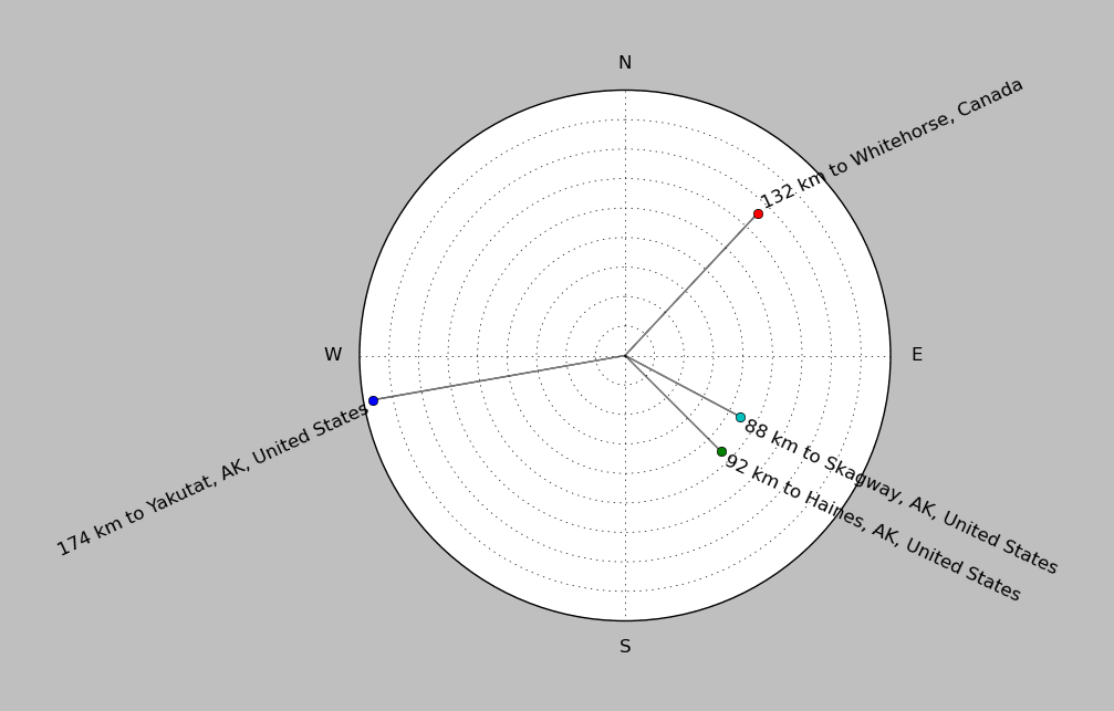
| ||||||||||||||||
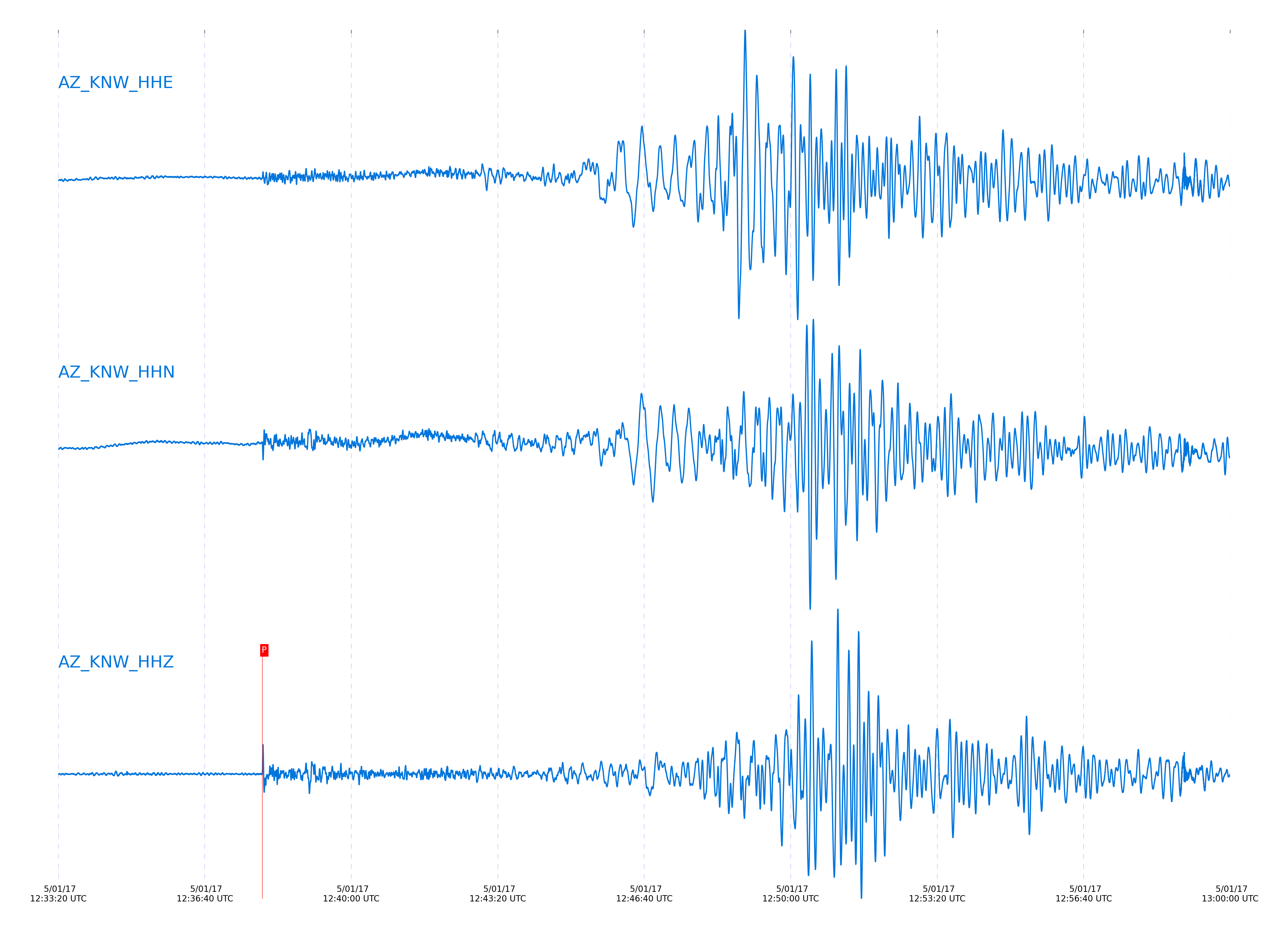
Event and active stations
|
|||||||||||||||||
Closest station with identified signal. Not filtered.
Subset of several stations close to the event. Not filtered.
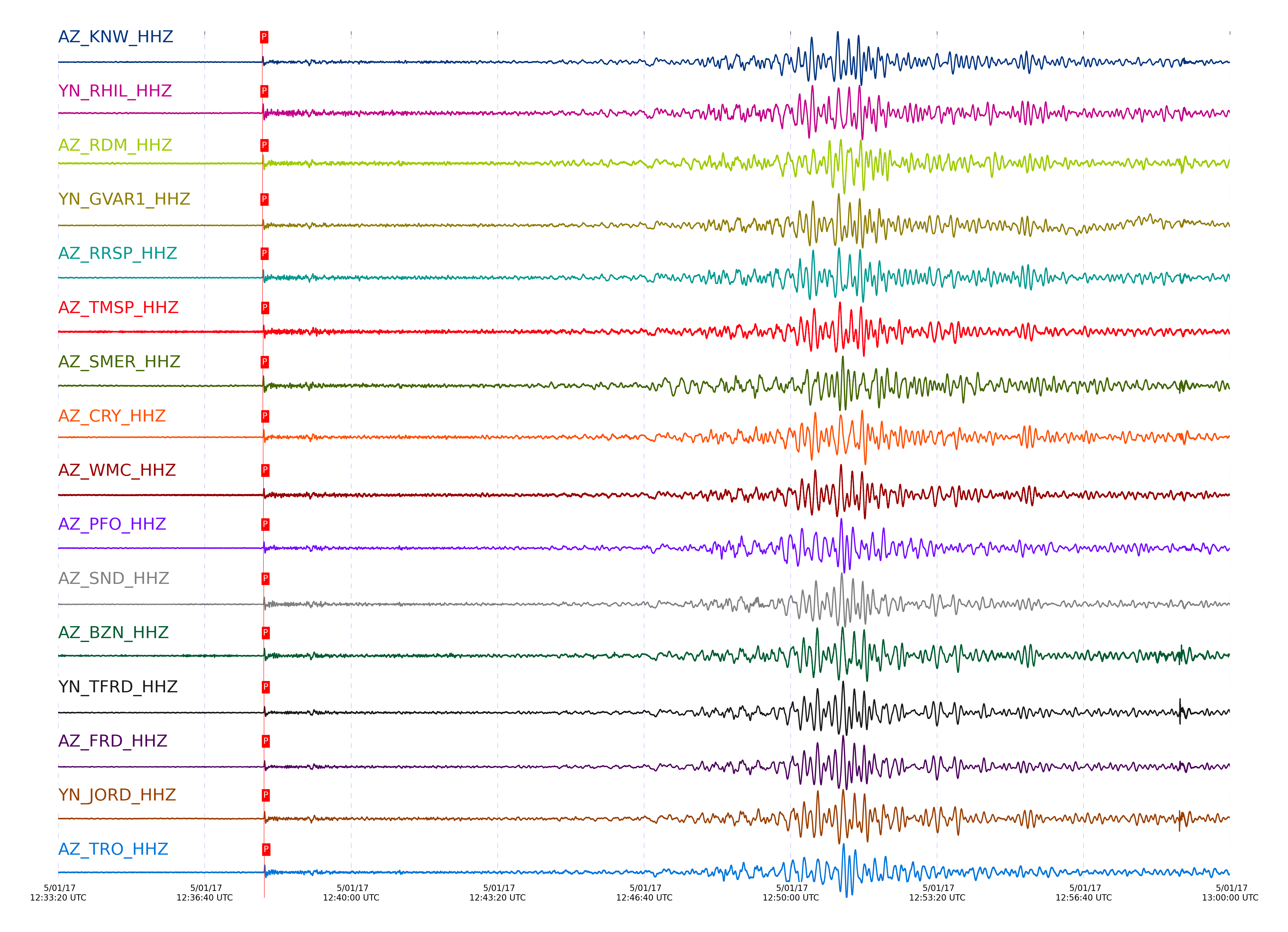
| STA_CHAN | S-E Delta | S-E Azimuth | Phase | Time | Signal/Noise | Time Residual | V. Model | Auth | arid |
|---|---|---|---|---|---|---|---|---|---|
| KNW_HHZ | 29.233° | 339.42° | pP | 2017-05-01 12:37:58.6054 UTC | 84.968 | 0.295 | iasp91 | dbp:jtytell:171 | 1387002 |
| RHIL_HHZ | 29.254° | 339.49° | pP | 2017-05-01 12:37:58.8971 UTC | -1 | 0.401 | iasp91 | dbp:jtytell:171 | 1387139 |
| RDM_HHZ | 29.272° | 339.59° | pP | 2017-05-01 12:37:59.0079 UTC | 106.14 | 0.35 | iasp91 | dbp:jtytell:171 | 1387004 |
| GVAR1_HHZ | 29.279° | 339.44° | pP | 2017-05-01 12:37:59.0757 UTC | -1 | 0.354 | iasp91 | dbp:jtytell:171 | 1387143 |
| RRSP_HHZ | 29.283° | 339.48° | pP | 2017-05-01 12:37:59.1813 UTC | -1 | 0.422 | iasp91 | dbp:jtytell:171 | 1387144 |
| TMSP_HHZ | 29.331° | 339.45° | pP | 2017-05-01 12:37:59.9393 UTC | -1 | 0.76 | iasp91 | dbp:jtytell:171 | 1387145 |
| SMER_HHZ | 29.341° | 339.96° | pP | 2017-05-01 12:37:59.4859 UTC | 79.369 | 0.219 | iasp91 | dbp:jtytell:171 | 1387006 |
| CRY_HHZ | 29.365° | 339.53° | pP | 2017-05-01 12:38:00.0149 UTC | 83.021 | 0.534 | iasp91 | dbp:jtytell:171 | 1387008 |
| WMC_HHZ | 29.375° | 339.48° | pP | 2017-05-01 12:38:00.244 UTC | 65.189 | 0.67 | iasp91 | dbp:jtytell:171 | 1387014 |
| PFO_HHZ | 29.403° | 339.27° | pP | 2017-05-01 12:38:00.3077 UTC | 69.84 | 0.489 | iasp91 | dbp:jtytell:171 | 1387012 |
| SND_HHZ | 29.414° | 339.44° | pP | 2017-05-01 12:38:00.4943 UTC | 65.694 | 0.579 | iasp91 | dbp:jtytell:171 | 1387010 |
| BZN_HHZ | 29.454° | 339.52° | pP | 2017-05-01 12:38:00.8106 UTC | 72.152 | 0.534 | iasp91 | dbp:jtytell:171 | 1387016 |
| TFRD_HHZ | 29.47° | 339.46° | pP | 2017-05-01 12:38:00.906 UTC | -1 | 0.489 | iasp91 | dbp:jtytell:171 | 1387154 |
| FRD_HHZ | 29.47° | 339.46° | pP | 2017-05-01 12:38:00.9744 UTC | 68.737 | 0.557 | iasp91 | dbp:jtytell:171 | 1387018 |
| JORD_HHZ | 29.479° | 339.51° | pP | 2017-05-01 12:38:00.9377 UTC | -1 | 0.444 | iasp91 | dbp:jtytell:171 | 1387155 |
| TRO_HHZ | 29.495° | 339.3° | pP | 2017-05-01 12:38:01.4661 UTC | 115.2 | 0.827 | iasp91 | dbp:jtytell:171 | 1387020 |
| TR02_HHZ | 29.596° | 339.36° | pP | 2017-05-01 12:38:02.1674 UTC | -1 | 0.634 | iasp91 | dbp:jtytell:171 | 1387161 |
| TR03_HHZ | 29.603° | 339.37° | pP | 2017-05-01 12:38:02.1469 UTC | -1 | 0.557 | iasp91 | dbp:jtytell:171 | 1387162 |
| TR04_HHZ | 29.612° | 339.38° | pP | 2017-05-01 12:38:02.2439 UTC | -1 | 0.573 | iasp91 | dbp:jtytell:171 | 1387164 |
| LVA2_HHZ | 29.616° | 339.52° | pP | 2017-05-01 12:38:02.2377 UTC | -1 | 0.527 | iasp91 | dbp:jtytell:171 | 1387165 |
| CPE_HHZ | 29.894° | 340.25° | pP | 2017-05-01 12:38:05.1116 UTC | 59.236 | 0.94 | iasp91 | dbp:jtytell:171 | 1387030 |
| SOL_HHZ | 29.899° | 340.4° | pP | 2017-05-01 12:38:05.3367 UTC | 24.422 | 1.123 | iasp91 | dbp:jtytell:171 | 1387031 |
| MONP2_HHZ | 30.088° | 339.68° | pP | 2017-05-01 12:38:06.9305 UTC | -1 | 1.047 | iasp91 | dbp:jtytell:171 | 1387174 |
Click the link below to observe an interactive map of earthquakes recorded by the station deployment:
Broadband Seismic Data Collection Center (ANZA),
Institute of Geophysics & Planetary Physics
Scripps Institution of Oceanography,
University of California San Diego
Copyright © 1989 - 2014. All Rights Reserved.