
last update to page: May 08 2017 20:37:00 (UTC).
SummaryThe red marker denotes the earthquake epicenter. On Mon May 8th 2017 17:00:47 (UTC) the seismic network recorded an earthquake (preliminary 6.2 mww) located in Andreanof Islands, Aleutian Is.. Seismic region Alaska - Aleutian Arc. The epicentral distance (i.e. distance separating the location to the epicenter) to the closest station CSLB in the network is 5,163.3 km. If you felt the quake, the USGS would like to know. Please add your comments to the USGS page "Did you feel it?". |
Details
Proximity to Population Centers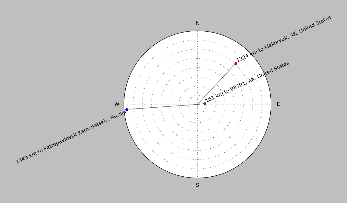
| ||||||||||||||||
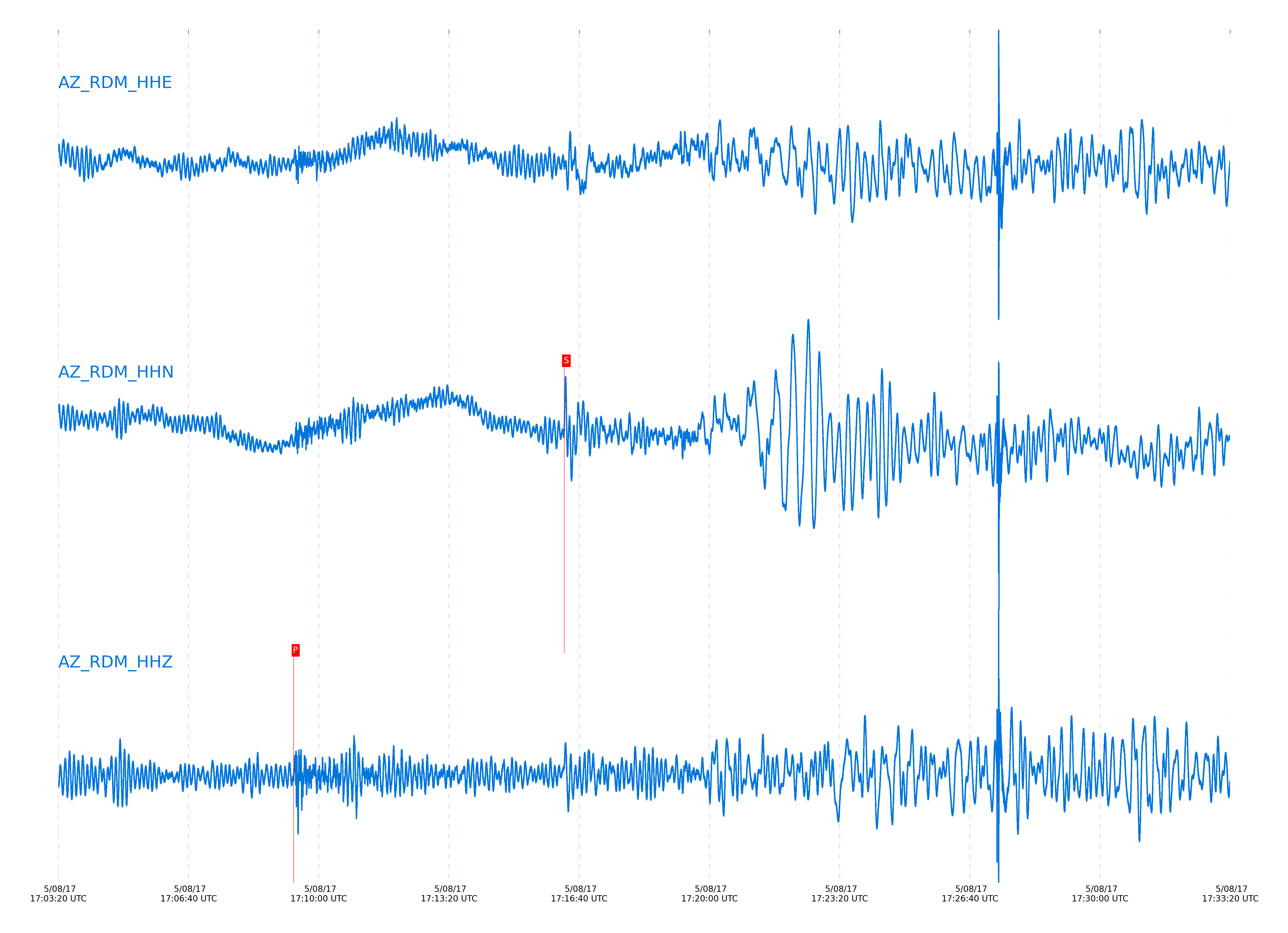
Event and active stations
|
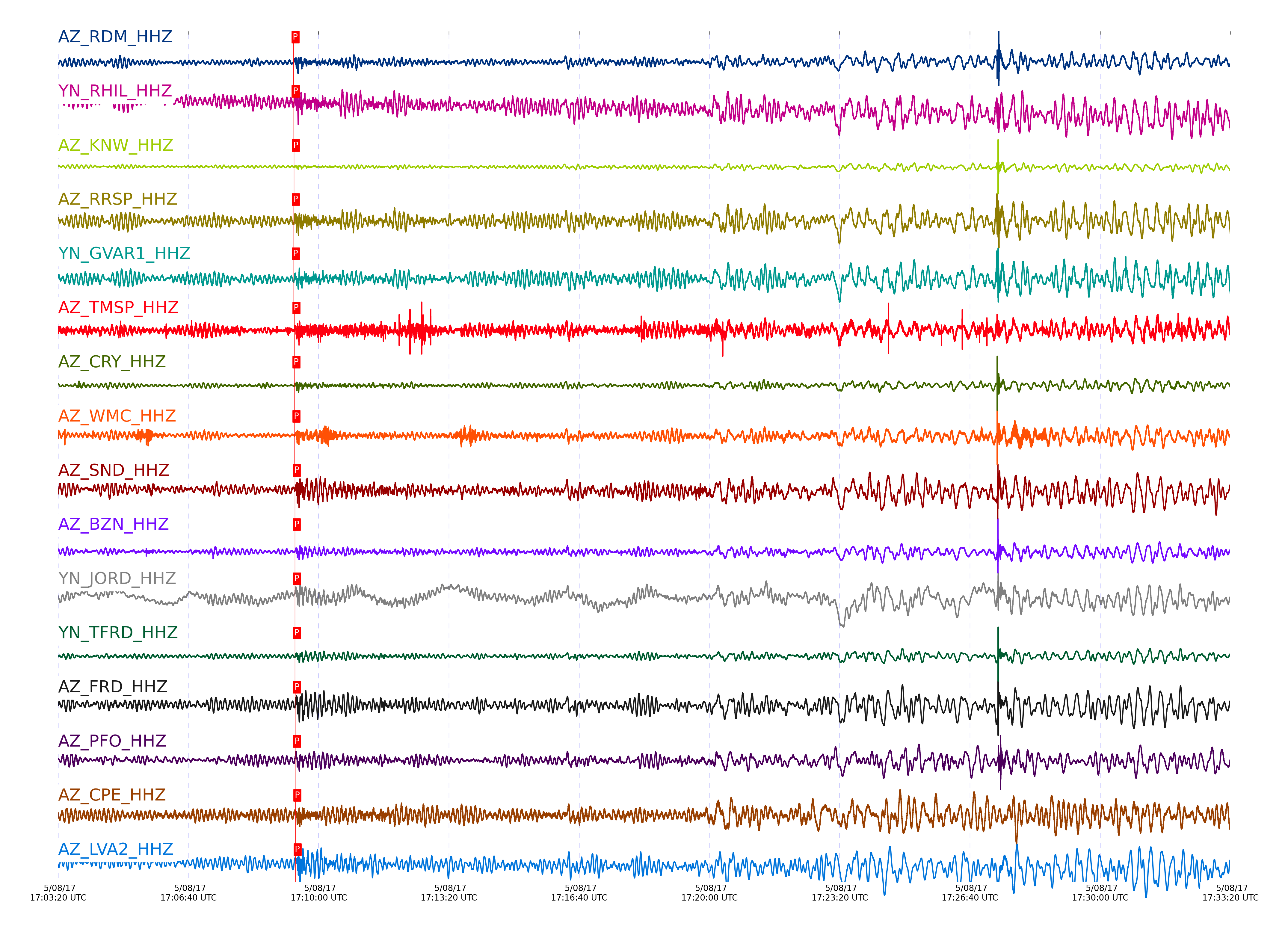
|||||||||||||||||
Closest station with identified signal. Not filtered.
Subset of several stations close to the event. Not filtered.
| STA_CHAN | S-E Delta | S-E Azimuth | Phase | Time | Signal/Noise | Time Residual | V. Model | Auth | arid |
|---|---|---|---|---|---|---|---|---|---|
| SMER_HHN | 47.18° | 312.15° | S | 2017-05-08 17:16:15.6268 UTC | -1 | 2.516 | iasp91 | dbp:jtytell:171 | 1392494 |
| RDM_HHZ | 47.265° | 312.04° | P | 2017-05-08 17:09:21.5532 UTC | 65.168 | 1.249 | iasp91 | dbp:jtytell:171 | 1392028 |
| RDM_HHN | 47.265° | 312.04° | S | 2017-05-08 17:16:17.0995 UTC | -1 | 2.788 | iasp91 | dbp:jtytell:171 | 1392495 |
| RHIL_HHZ | 47.283° | 312.01° | P | 2017-05-08 17:09:21.8022 UTC | -1 | 1.354 | iasp91 | dbp:jtytell:171 | 1392441 |
| RHIL_HHN | 47.283° | 312.01° | S | 2017-05-08 17:16:16.8352 UTC | -1 | 2.261 | iasp91 | dbp:jtytell:171 | 1392496 |
| KNW_HHZ | 47.292° | 311.99° | P | 2017-05-08 17:09:22.0641 UTC | -1 | 1.543 | iasp91 | dbp:jtytell:171 | 1392442 |
| RRSP_HHZ | 47.317° | 312.03° | P | 2017-05-08 17:09:21.9934 UTC | -1 | 1.278 | iasp91 | dbp:jtytell:171 | 1392444 |
| RRSP_HHN | 47.317° | 312.03° | S | 2017-05-08 17:16:17.3739 UTC | -1 | 2.312 | iasp91 | dbp:jtytell:171 | 1392497 |
| GVAR1_HHZ | 47.328° | 312.02° | P | 2017-05-08 17:09:21.9224 UTC | -1 | 1.127 | iasp91 | dbp:jtytell:171 | 1392445 |
| GVAR1_HHE | 47.328° | 312.02° | S | 2017-05-08 17:16:20.7163 UTC | -1 | 5.507 | iasp91 | dbp:jtytell:171 | 1392498 |
| TMSP_HHZ | 47.375° | 312.05° | pP | 2017-05-08 17:09:22.8608 UTC | -1 | -1.455 | iasp91 | dbp:jtytell:171 | 1392449 |
| CRY_HHZ | 47.376° | 312.09° | pP | 2017-05-08 17:09:22.8328 UTC | 65.607 | -1.492 | iasp91 | dbp:jtytell:171 | 1392031 |
| WMC_HHZ | 47.409° | 312.09° | pP | 2017-05-08 17:09:23.0153 UTC | 44.925 | -1.568 | iasp91 | dbp:jtytell:171 | 1392039 |
| SND_HHZ | 47.462° | 312.1° | pP | 2017-05-08 17:09:23.4639 UTC | 27.577 | -1.531 | iasp91 | dbp:jtytell:171 | 1392033 |
| SND_HHN | 47.462° | 312.1° | S | 2017-05-08 17:16:20.2694 UTC | -1 | 3.145 | iasp91 | dbp:jtytell:171 | 1392502 |
| BZN_HHZ | 47.469° | 312.14° | pP | 2017-05-08 17:09:23.5196 UTC | 46.695 | -1.53 | iasp91 | dbp:jtytell:171 | 1392032 |
| BZN_HHN | 47.469° | 312.14° | S | 2017-05-08 17:16:20.3244 UTC | -1 | 3.099 | iasp91 | dbp:jtytell:171 | 1392503 |
| JORD_HHZ | 47.496° | 312.16° | pP | 2017-05-08 17:09:23.7643 UTC | -1 | -1.492 | iasp91 | dbp:jtytell:171 | 1392453 |
| JORD_HHN | 47.496° | 312.16° | S | 2017-05-08 17:16:20.6669 UTC | -1 | 3.064 | iasp91 | dbp:jtytell:171 | 1392504 |
| TFRD_HHZ | 47.507° | 312.14° | pP | 2017-05-08 17:09:23.8518 UTC | -1 | -1.492 | iasp91 | dbp:jtytell:171 | 1392455 |
| TFRD_HHN | 47.507° | 312.14° | S | 2017-05-08 17:16:21.0266 UTC | -1 | 3.263 | iasp91 | dbp:jtytell:171 | 1392505 |
| FRD_HHZ | 47.507° | 312.14° | pP | 2017-05-08 17:09:23.966 UTC | 29.912 | -1.379 | iasp91 | dbp:jtytell:171 | 1392035 |
| FRD_HHN | 47.507° | 312.14° | S | 2017-05-08 17:16:21.0272 UTC | -1 | 3.263 | iasp91 | dbp:jtytell:171 | 1392506 |
| PFO_HHZ | 47.517° | 312.07° | pP | 2017-05-08 17:09:23.9272 UTC | 18.456 | -1.494 | iasp91 | dbp:jtytell:171 | 1392034 |
| PFO_HHN | 47.517° | 312.07° | S | 2017-05-08 17:16:20.4242 UTC | -1 | 2.52 | iasp91 | dbp:jtytell:171 | 1392508 |
| TRO_HHZ | 47.597° | 312.13° | pP | 2017-05-08 17:09:24.9293 UTC | 11.867 | -1.115 | iasp91 | dbp:jtytell:171 | 1392038 |
| CPE_HHZ | 47.604° | 312.54° | P | 2017-05-08 17:09:24.3864 UTC | 14.461 | 1.439 | iasp91 | dbp:jtytell:171 | 1392037 |
| CPE_HHN | 47.604° | 312.54° | S | 2017-05-08 17:16:22.0526 UTC | -1 | 2.91 | iasp91 | dbp:jtytell:171 | 1392514 |
| LVA2_HHZ | 47.628° | 312.24° | P | 2017-05-08 17:09:24.6828 UTC | 29.485 | 1.546 | iasp91 | dbp:jtytell:171 | 1392036 |
| LVA2_HHN | 47.628° | 312.24° | S | 2017-05-08 17:16:23.6009 UTC | -1 | 4.113 | iasp91 | dbp:jtytell:171 | 1392515 |
| TR01_HHZ | 47.672° | 312.2° | pP | 2017-05-08 17:09:25.2477 UTC | -1 | -1.38 | iasp91 | dbp:jtytell:171 | 1392467 |
| TR01_HHN | 47.672° | 312.2° | S | 2017-05-08 17:16:23.5319 UTC | -1 | 3.424 | iasp91 | dbp:jtytell:171 | 1392517 |
| TR02_HHZ | 47.673° | 312.2° | pP | 2017-05-08 17:09:25.218 UTC | -1 | -1.418 | iasp91 | dbp:jtytell:171 | 1392468 |
| TR02_HHN | 47.673° | 312.2° | S | 2017-05-08 17:16:23.5401 UTC | -1 | 3.417 | iasp91 | dbp:jtytell:171 | 1392518 |
| TR03_HHZ | 47.675° | 312.21° | pP | 2017-05-08 17:09:25.1191 UTC | -1 | -1.531 | iasp91 | dbp:jtytell:171 | 1392469 |
| TR03_HHN | 47.675° | 312.21° | S | 2017-05-08 17:16:23.4189 UTC | -1 | 3.269 | iasp91 | dbp:jtytell:171 | 1392519 |
| TR04_HHZ | 47.68° | 312.21° | pP | 2017-05-08 17:09:25.2 UTC | -1 | -1.493 | iasp91 | dbp:jtytell:171 | 1392470 |
| TR04_HHN | 47.68° | 312.21° | S | 2017-05-08 17:16:23.8695 UTC | -1 | 3.642 | iasp91 | dbp:jtytell:171 | 1392520 |
| MONP2_HHZ | 48.024° | 312.55° | P | 2017-05-08 17:09:27.4549 UTC | -1 | 1.247 | iasp91 | dbp:jtytell:171 | 1392478 |
| MONP2_HHN | 48.024° | 312.55° | S | 2017-05-08 17:16:28.4391 UTC | -1 | 3.333 | iasp91 | dbp:jtytell:171 | 1392530 |
Click the link below to observe an interactive map of earthquakes recorded by the station deployment:
Broadband Seismic Data Collection Center (ANZA),
Institute of Geophysics & Planetary Physics
Scripps Institution of Oceanography,
University of California San Diego
Copyright © 1989 - 2014. All Rights Reserved.