
last update to page: June 08 2017 19:06:43 (UTC).
SummaryThe red marker denotes the earthquake epicenter. On Thu Jun 8th 2017 17:01:19 (UTC) the seismic network recorded an earthquake (preliminary 5.28 ml) located in Hawaii. Seismic region Pacific Basin. The epicentral distance (i.e. distance separating the location to the epicenter) to the closest station SCI2 in the network is 3,935.6 km. If you felt the quake, the USGS would like to know. Please add your comments to the USGS page "Did you feel it?". |
Details
Proximity to Population Centers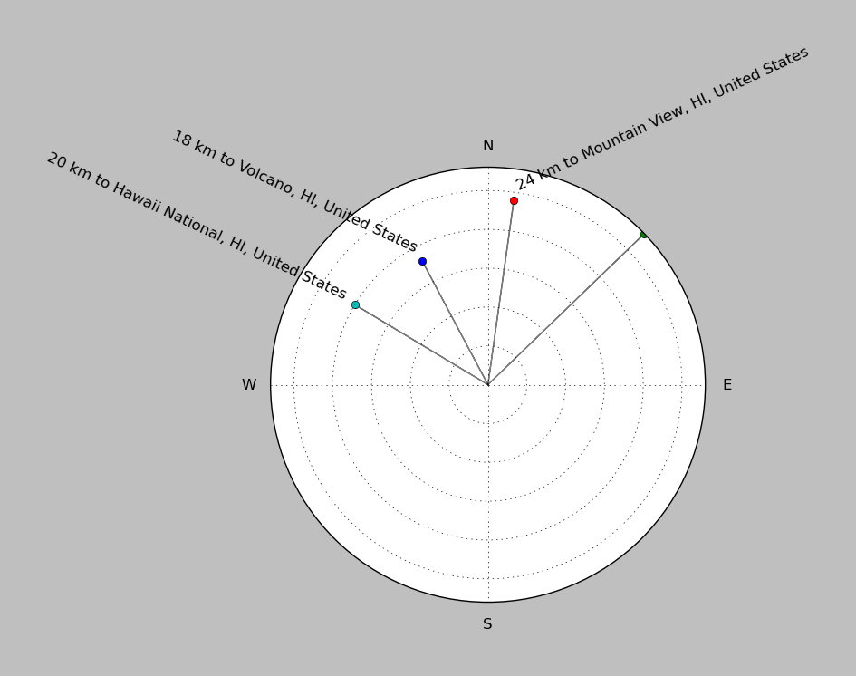
| ||||||||||||||||
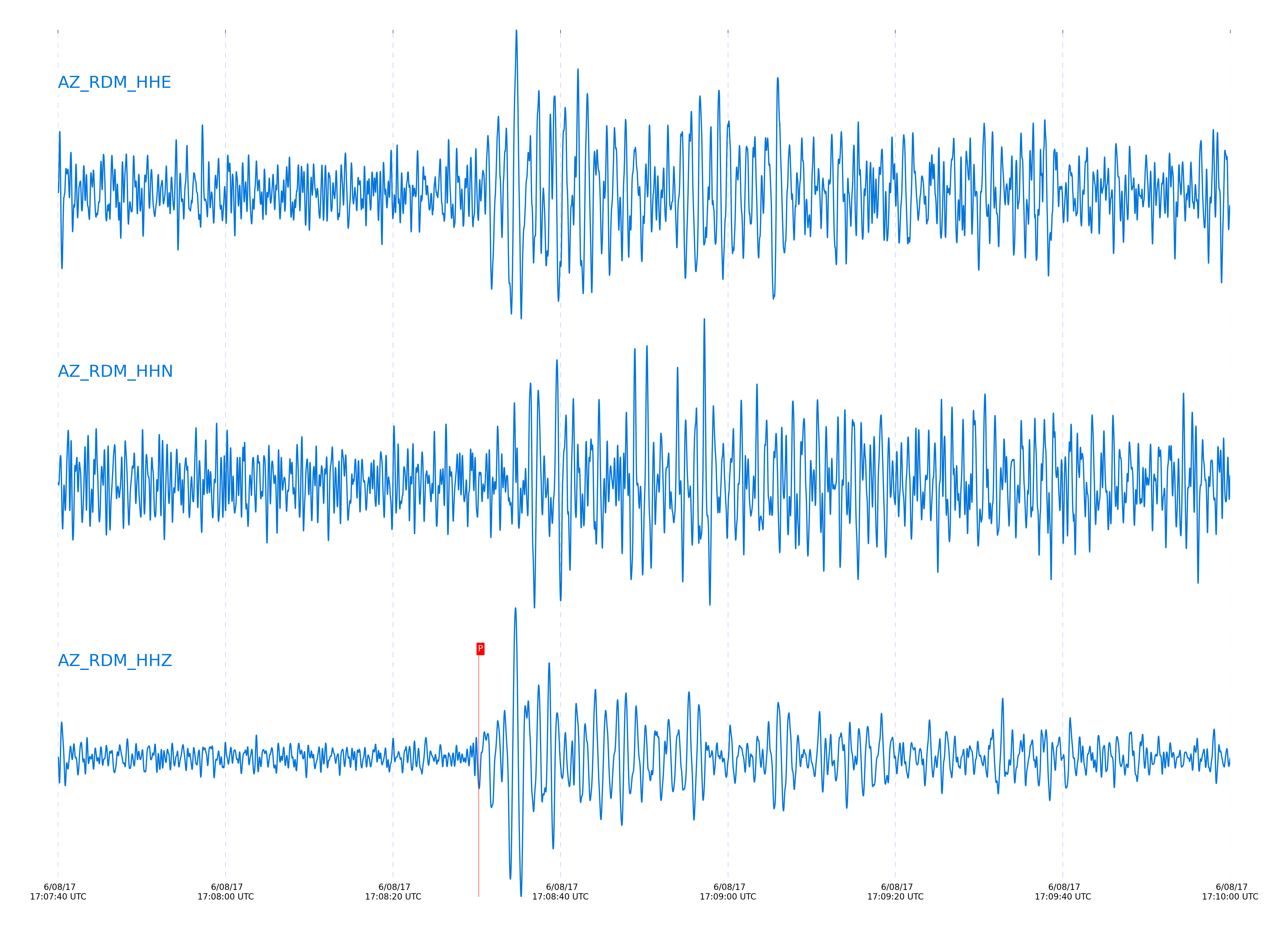
Event and active stations
|
|||||||||||||||||
Closest station with identified signal. 0.8 to 3 Hz bandpass Butterworth filter has been applied to data.
Subset of several stations close to the event. 0.8 to 3 Hz bandpass Butterworth filter has been applied to data.
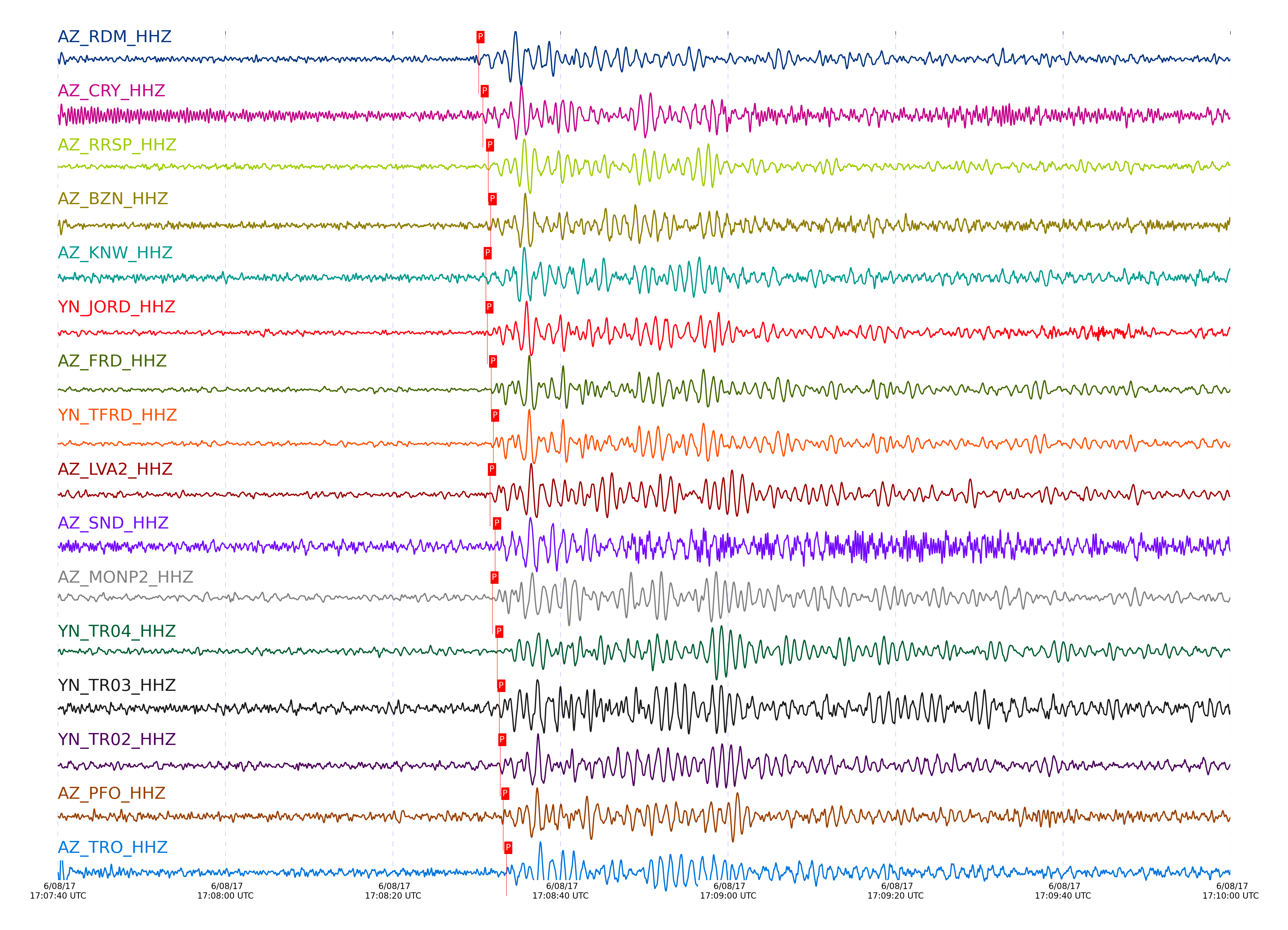
| STA_CHAN | S-E Delta | S-E Azimuth | Phase | Time | Signal/Noise | Time Residual | V. Model | Auth | arid |
|---|---|---|---|---|---|---|---|---|---|
| RDM_HHZ | 36.852° | 257.03° | pP | 2017-06-08 17:08:30.2259 UTC | 11.751 | -0.236 | iasp91 | dbp:jtytell:171 | 1420144 |
| CRY_HHZ | 36.927° | 257.2° | pP | 2017-06-08 17:08:30.7172 UTC | 10.065 | -0.386 | iasp91 | dbp:jtytell:171 | 1420145 |
| RRSP_HHZ | 36.945° | 257.09° | pP | 2017-06-08 17:08:31.3624 UTC | -1 | 0.111 | iasp91 | dbp:jtytell:171 | 1420290 |
| BZN_HHZ | 36.968° | 257.35° | pP | 2017-06-08 17:08:31.661 UTC | 11.534 | 0.21 | iasp91 | dbp:jtytell:171 | 1420150 |
| KNW_HHZ | 36.981° | 257.03° | pP | 2017-06-08 17:08:31.0747 UTC | 11.471 | -0.485 | iasp91 | dbp:jtytell:171 | 1420148 |
| JORD_HHZ | 36.982° | 257.4° | pP | 2017-06-08 17:08:31.2803 UTC | 11.113 | -0.287 | iasp91 | dbp:jtytell:171 | 1420152 |
| FRD_HHZ | 37.022° | 257.4° | pP | 2017-06-08 17:08:31.7174 UTC | 10.384 | -0.187 | iasp91 | dbp:jtytell:171 | 1420149 |
| TFRD_HHZ | 37.022° | 257.4° | pP | 2017-06-08 17:08:31.966 UTC | -1 | 0.061 | iasp91 | dbp:jtytell:171 | 1420292 |
| LVA2_HHZ | 37.024° | 257.62° | pP | 2017-06-08 17:08:31.5872 UTC | -1 | -0.337 | iasp91 | dbp:jtytell:171 | 1420293 |
| SND_HHZ | 37.025° | 257.32° | pP | 2017-06-08 17:08:32.197 UTC | 7.0512 | 0.26 | iasp91 | dbp:jtytell:171 | 1420154 |
| MONP2_HHZ | 37.042° | 258.32° | pP | 2017-06-08 17:08:31.8911 UTC | -1 | -0.188 | iasp91 | dbp:jtytell:171 | 1420294 |
| TR04_HHZ | 37.145° | 257.66° | pP | 2017-06-08 17:08:32.4623 UTC | -1 | -0.486 | iasp91 | dbp:jtytell:171 | 1420295 |
| TR03_HHZ | 37.149° | 257.65° | pP | 2017-06-08 17:08:32.6992 UTC | -1 | -0.287 | iasp91 | dbp:jtytell:171 | 1420296 |
| TR02_HHZ | 37.156° | 257.65° | pP | 2017-06-08 17:08:32.8098 UTC | -1 | -0.238 | iasp91 | dbp:jtytell:171 | 1420297 |
| PFO_HHZ | 37.163° | 257.36° | pP | 2017-06-08 17:08:33.1687 UTC | 5.2176 | 0.06 | iasp91 | dbp:jtytell:171 | 1420157 |
| TRO_HHZ | 37.172° | 257.5° | pP | 2017-06-08 17:08:33.5364 UTC | 9.02 | 0.358 | iasp91 | dbp:jtytell:171 | 1420159 |
Click the link below to observe an interactive map of earthquakes recorded by the station deployment:
Broadband Seismic Data Collection Center (ANZA),
Institute of Geophysics & Planetary Physics
Scripps Institution of Oceanography,
University of California San Diego
Copyright © 1989 - 2014. All Rights Reserved.