
last update to page: June 22 2017 17:29:27 (UTC).
SummaryThe red marker denotes the earthquake epicenter. On Thu Jun 22nd 2017 12:31:04 (UTC) the seismic network recorded an earthquake (preliminary 6.8 mww) located in Near Coast Of Guatemala. Seismic region Mexico - Guatemala Area. The epicentral distance (i.e. distance separating the location to the epicenter) to the closest station USGCB in the network is 3,329.6 km. If you felt the quake, the USGS would like to know. Please add your comments to the USGS page "Did you feel it?". |
Details
Proximity to Population Centers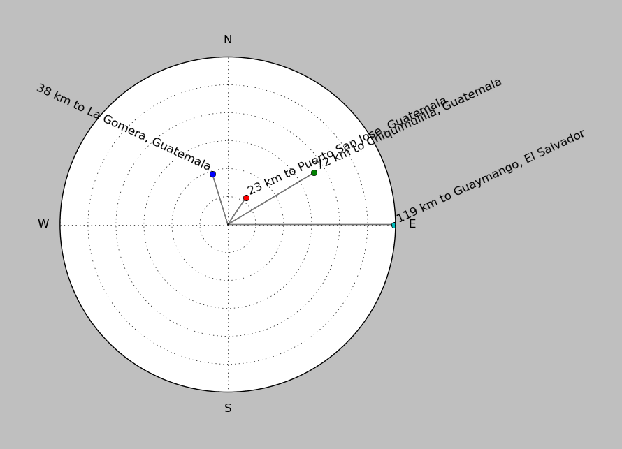
| ||||||||||||||||
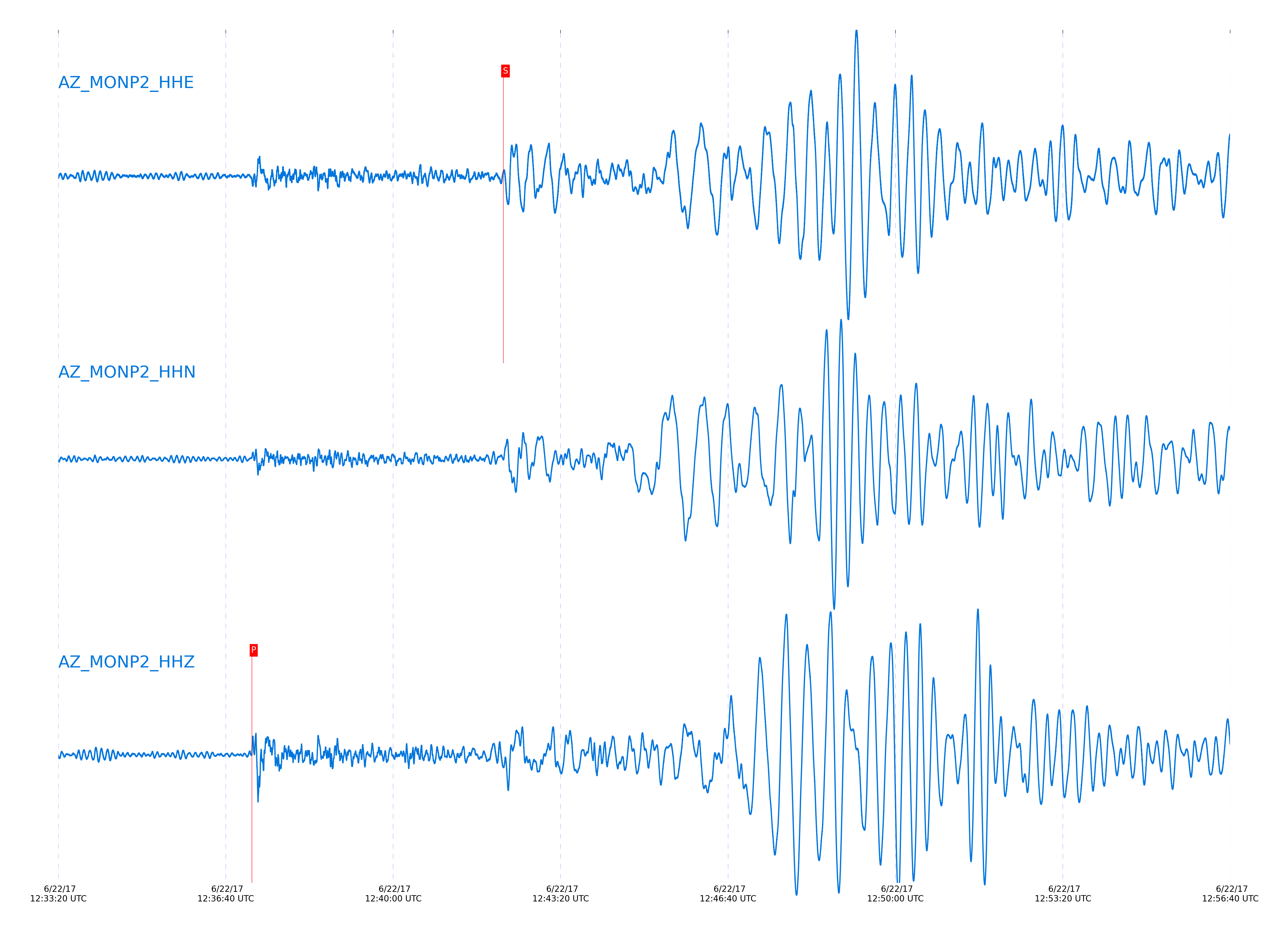
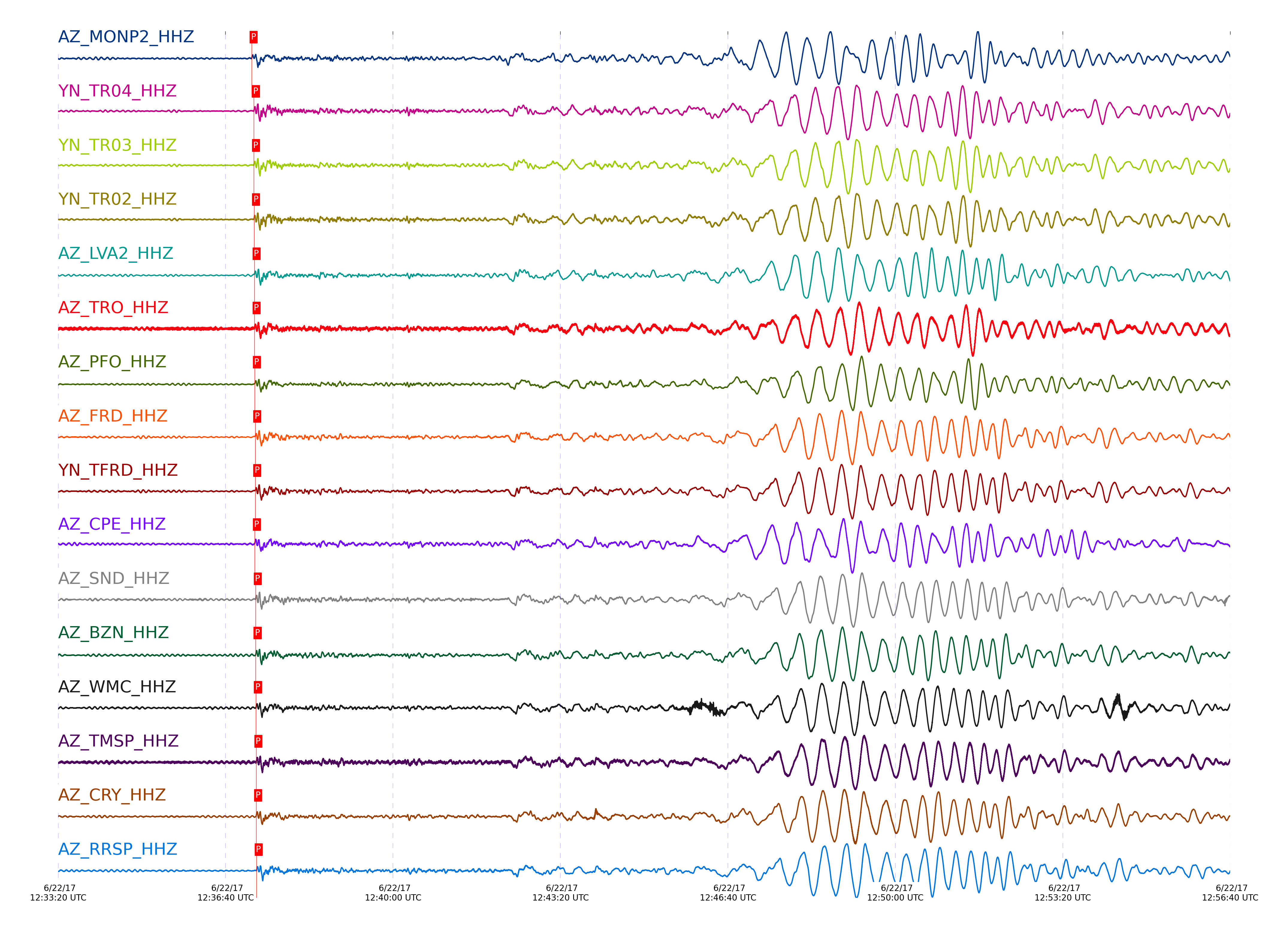
Event and active stations
|
|||||||||||||||||
Closest station with identified signal. Not filtered.
Subset of several stations close to the event. Not filtered.
| STA_CHAN | S-E Delta | S-E Azimuth | Phase | Time | Signal/Noise | Time Residual | V. Model | Auth | arid |
|---|---|---|---|---|---|---|---|---|---|
| MONP2_HHZ | 30.068° | 123.51° | P | 2017-06-22 12:37:11.1951 UTC | 45.928 | 1.988 | iasp91 | dbp:jtytell:171 | 1434236 |
| MONP2_HHE | 30.068° | 123.51° | S | 2017-06-22 12:42:11.6178 UTC | -1 | 6.472 | iasp91 | dbp:jtytell:171 | 1434402 |
| TR04_HHZ | 30.353° | 124.22° | P | 2017-06-22 12:37:13.8105 UTC | -1 | 2.087 | iasp91 | dbp:jtytell:171 | 1434359 |
| TR04_HHE | 30.353° | 124.22° | S | 2017-06-22 12:42:17.9774 UTC | -1 | 8.371 | iasp91 | dbp:jtytell:171 | 1434411 |
| TR03_HHZ | 30.357° | 124.24° | P | 2017-06-22 12:37:13.8969 UTC | -1 | 2.137 | iasp91 | dbp:jtytell:171 | 1434360 |
| TR03_HHE | 30.357° | 124.24° | S | 2017-06-22 12:42:18.3984 UTC | -1 | 8.727 | iasp91 | dbp:jtytell:171 | 1434412 |
| TR02_HHZ | 30.357° | 124.26° | P | 2017-06-22 12:37:14.05 UTC | -1 | 2.286 | iasp91 | dbp:jtytell:171 | 1434361 |
| TR02_HHE | 30.357° | 124.26° | S | 2017-06-22 12:42:18.4025 UTC | -1 | 8.724 | iasp91 | dbp:jtytell:171 | 1434413 |
| TR01_HHE | 30.358° | 124.28° | S | 2017-06-22 12:42:19.174 UTC | -1 | 9.491 | iasp91 | dbp:jtytell:171 | 1434414 |
| LVA2_HHZ | 30.42° | 123.98° | P | 2017-06-22 12:37:14.6521 UTC | 66.669 | 2.335 | iasp91 | dbp:jtytell:171 | 1434204 |
| LVA2_HHE | 30.42° | 123.98° | S | 2017-06-22 12:42:20.4923 UTC | -1 | 9.835 | iasp91 | dbp:jtytell:171 | 1434416 |
| TRO_HHZ | 30.423° | 124.4° | P | 2017-06-22 12:37:14.7265 UTC | 68.728 | 2.385 | iasp91 | dbp:jtytell:171 | 1434205 |
| PFO_HHZ | 30.496° | 124.48° | P | 2017-06-22 12:37:15.073 UTC | 62.621 | 2.087 | iasp91 | dbp:jtytell:171 | 1434206 |
| PFO_HHE | 30.496° | 124.48° | S | 2017-06-22 12:42:21.1616 UTC | -1 | 9.317 | iasp91 | dbp:jtytell:171 | 1434423 |
| FRD_HHZ | 30.528° | 124.12° | P | 2017-06-22 12:37:15.4578 UTC | 63.203 | 2.186 | iasp91 | dbp:jtytell:171 | 1434210 |
| FRD_HHE | 30.528° | 124.12° | S | 2017-06-22 12:42:21.8314 UTC | -1 | 9.481 | iasp91 | dbp:jtytell:171 | 1434426 |
| TFRD_HHZ | 30.528° | 124.12° | P | 2017-06-22 12:37:15.5577 UTC | -1 | 2.286 | iasp91 | dbp:jtytell:171 | 1434373 |
| TFRD_HHE | 30.528° | 124.12° | S | 2017-06-22 12:42:21.8319 UTC | -1 | 9.48 | iasp91 | dbp:jtytell:171 | 1434427 |
| JORD_HHE | 30.545° | 124.03° | S | 2017-06-22 12:42:21.2123 UTC | -1 | 8.596 | iasp91 | dbp:jtytell:171 | 1434428 |
| CPE_HHE | 30.547° | 122.6° | S | 2017-06-22 12:42:20.0718 UTC | -1 | 7.434 | iasp91 | dbp:jtytell:171 | 1434429 |
| CPE_HHZ | 30.547° | 122.6° | P | 2017-06-22 12:37:14.974 UTC | 27.982 | 1.54 | iasp91 | dbp:jtytell:171 | 1434212 |
| SND_HHE | 30.568° | 124.19° | S | 2017-06-22 12:42:22.564 UTC | -1 | 9.596 | iasp91 | dbp:jtytell:171 | 1434431 |
| SND_HHZ | 30.568° | 124.19° | P | 2017-06-22 12:37:16.0545 UTC | 41.574 | 2.435 | iasp91 | dbp:jtytell:171 | 1434218 |
| BZN_HHE | 30.571° | 124.03° | S | 2017-06-22 12:42:21.0572 UTC | -1 | 8.035 | iasp91 | dbp:jtytell:171 | 1434432 |
| BZN_HHZ | 30.571° | 124.03° | P | 2017-06-22 12:37:15.9857 UTC | 79.182 | 2.335 | iasp91 | dbp:jtytell:171 | 1434214 |
| SIO5_HHZ | 30.623° | 122.34° | P | 2017-06-22 12:37:15.9473 UTC | 14.56 | 1.839 | iasp91 | dbp:jtytell:171 | 1434221 |
| WMC_HHZ | 30.623° | 124.14° | P | 2017-06-22 12:37:16.289 UTC | 49.117 | 2.186 | iasp91 | dbp:jtytell:171 | 1434219 |
| WMC_HHE | 30.623° | 124.14° | S | 2017-06-22 12:42:22.6627 UTC | -1 | 8.838 | iasp91 | dbp:jtytell:171 | 1434434 |
| TMSP_HHZ | 30.652° | 124.19° | P | 2017-06-22 12:37:16.8008 UTC | -1 | 2.435 | iasp91 | dbp:jtytell:171 | 1434378 |
| TMSP_HHE | 30.652° | 124.19° | S | 2017-06-22 12:42:23.3103 UTC | -1 | 9.019 | iasp91 | dbp:jtytell:171 | 1434437 |
| CRY_HHZ | 30.661° | 124.04° | P | 2017-06-22 12:37:16.5796 UTC | 73.421 | 2.137 | iasp91 | dbp:jtytell:171 | 1434216 |
| CRY_HHE | 30.661° | 124.04° | S | 2017-06-22 12:42:23.0029 UTC | -1 | 8.575 | iasp91 | dbp:jtytell:171 | 1434438 |
| RRSP_HHZ | 30.711° | 124.16° | P | 2017-06-22 12:37:17.2164 UTC | -1 | 2.335 | iasp91 | dbp:jtytell:171 | 1434380 |
| RRSP_HHE | 30.711° | 124.16° | S | 2017-06-22 12:42:23.8253 UTC | -1 | 8.62 | iasp91 | dbp:jtytell:171 | 1434440 |
| KNW_HHZ | 30.727° | 124.28° | P | 2017-06-22 12:37:17.1114 UTC | 86.036 | 2.087 | iasp91 | dbp:jtytell:171 | 1434243 |
| KNW_HHN | 30.727° | 124.28° | S | 2017-06-22 12:42:23.9687 UTC | -1 | 8.509 | iasp91 | dbp:jtytell:171 | 1434441 |
| RHIL_HHZ | 30.745° | 124.14° | P | 2017-06-22 12:37:17.567 UTC | -1 | 2.385 | iasp91 | dbp:jtytell:171 | 1434383 |
| RHIL_HHE | 30.745° | 124.14° | S | 2017-06-22 12:42:24.1262 UTC | -1 | 8.388 | iasp91 | dbp:jtytell:171 | 1434442 |
| RDM_HHZ | 30.774° | 123.98° | P | 2017-06-22 12:37:17.421 UTC | 85.449 | 1.988 | iasp91 | dbp:jtytell:171 | 1434242 |
| RDM_HHE | 30.774° | 123.98° | S | 2017-06-22 12:42:25.5308 UTC | -1 | 9.346 | iasp91 | dbp:jtytell:171 | 1434444 |
| SMER_HHZ | 30.902° | 123.31° | P | 2017-06-22 12:37:18.3053 UTC | 59.695 | 1.739 | iasp91 | dbp:jtytell:171 | 1434245 |
| SMER_HHE | 30.902° | 123.31° | S | 2017-06-22 12:42:26.6635 UTC | -1 | 8.47 | iasp91 | dbp:jtytell:171 | 1434449 |
Click the link below to observe an interactive map of earthquakes recorded by the station deployment:
Broadband Seismic Data Collection Center (ANZA),
Institute of Geophysics & Planetary Physics
Scripps Institution of Oceanography,
University of California San Diego
Copyright © 1989 - 2014. All Rights Reserved.