
last update to page: August 09 2017 23:14:37 (UTC).
SummaryThe red marker denotes the earthquake epicenter. On Wed Aug 9th 2017 20:40:50 (UTC) the seismic network recorded an earthquake (preliminary 3.49 mw) located in Southern California. Seismic region California - Nevada Region. The epicentral distance (i.e. distance separating the location to the epicenter) to the closest station WRDG in the network is 58.5 km. If you felt the quake, the USGS would like to know. Please add your comments to the USGS page "Did you feel it?". |
Details
Proximity to Population Centers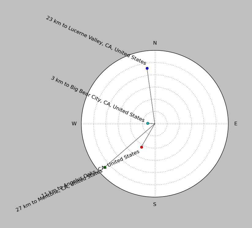
| ||||||||||||||||
Event and active stations
|
|||||||||||||||||
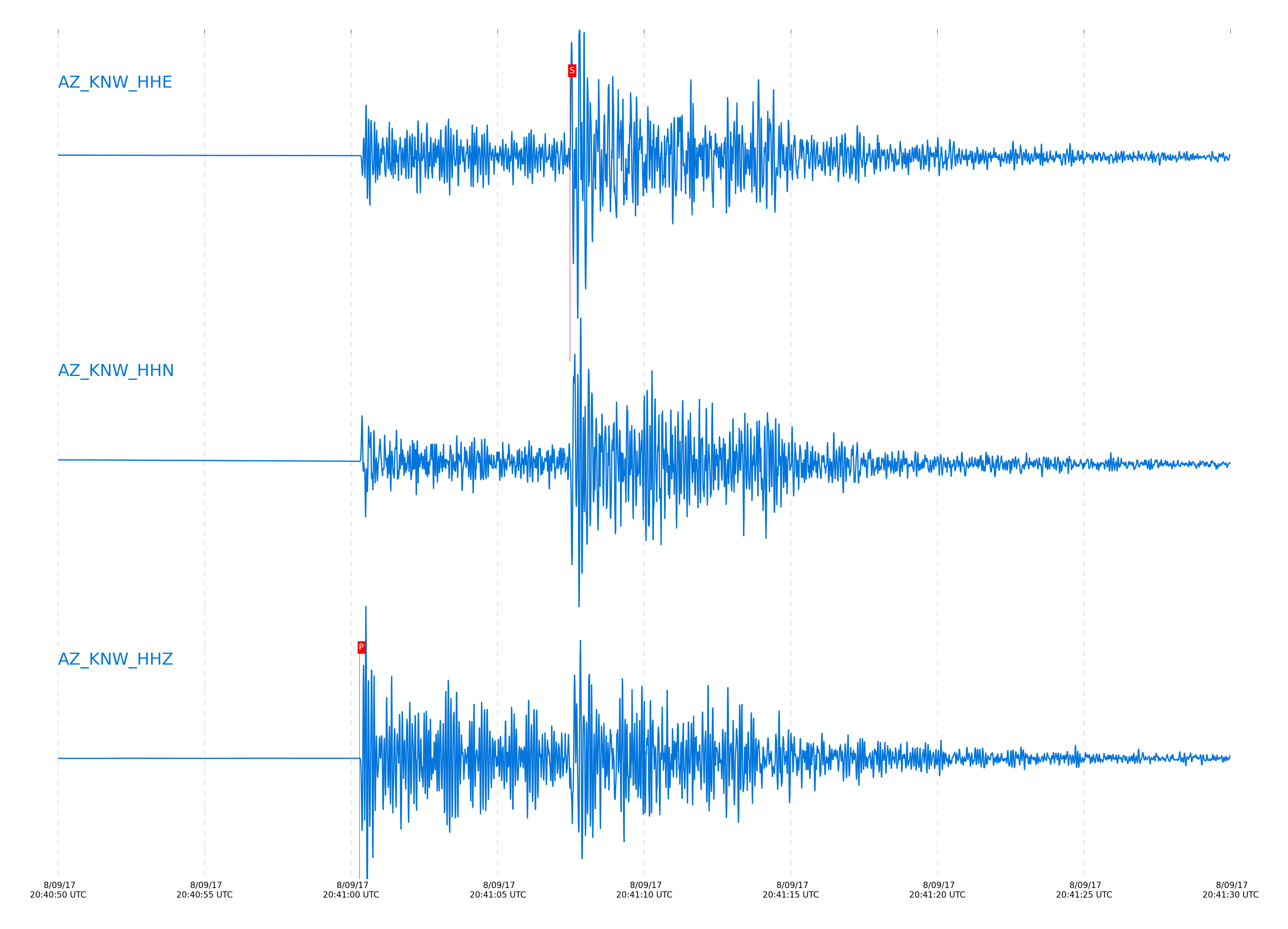
Closest station with identified signal. Not filtered.
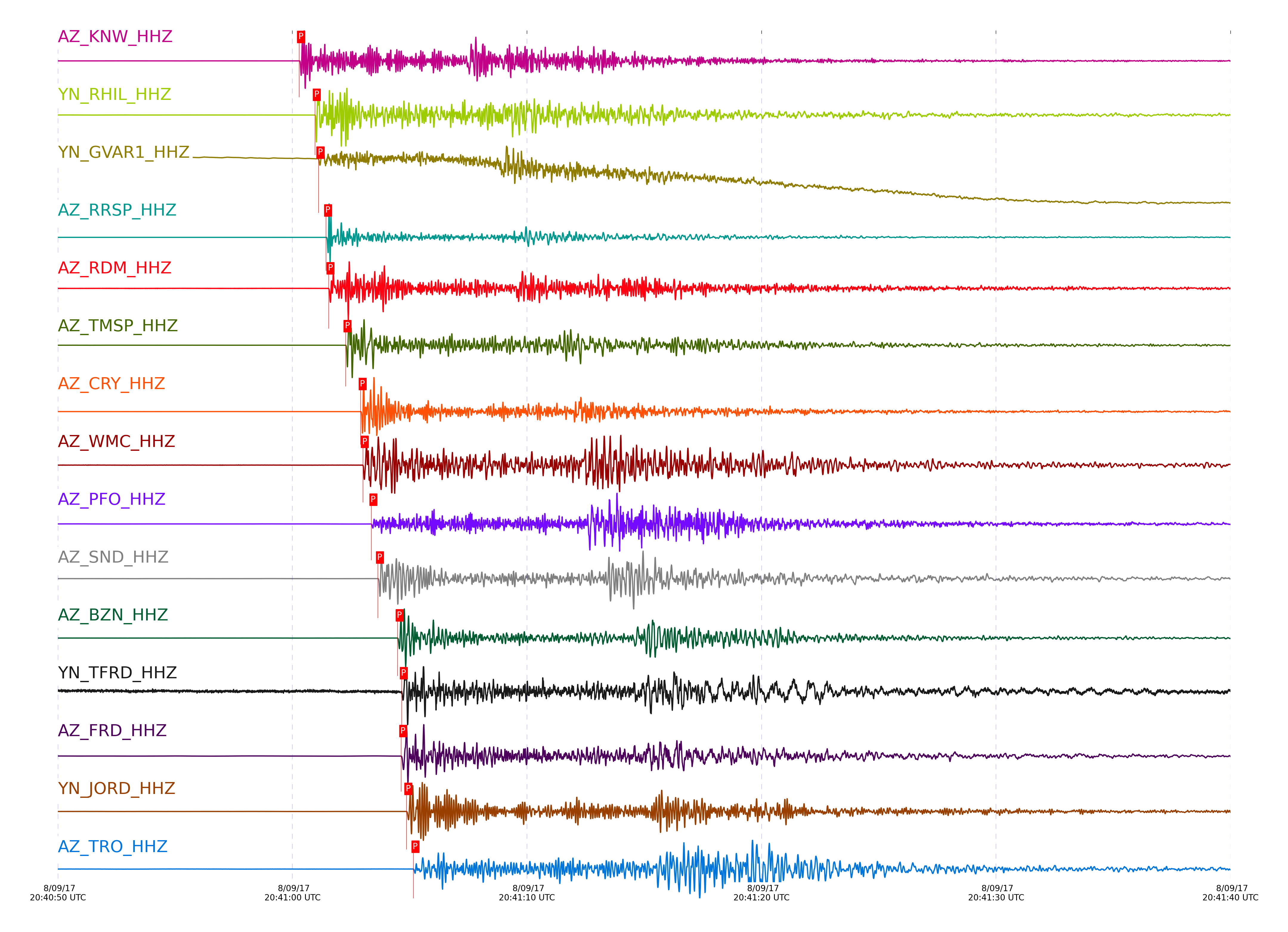
Subset of several stations close to the event. Not filtered.
| STA_CHAN | S-E Delta | S-E Azimuth | Phase | Time | Signal/Noise | Time Residual | V. Model | Auth | arid |
|---|---|---|---|---|---|---|---|---|---|
| KNW_HHZ | 0.545° | 344.71° | Pg | 2017-08-09 20:41:00.2891 UTC | 186.59 | -0.411 | iasp91 | dbp:jtytell:172 | 1478988 |
| KNW_HHE | 0.545° | 344.71° | Sg | 2017-08-09 20:41:07.4711 UTC | -1 | -0.878 | iasp91 | dbp:jtytell:172 | 1479107 |
| RHIL_HHZ | 0.574° | 350.52° | Pg | 2017-08-09 20:41:00.9601 UTC | -1 | -0.298 | iasp91 | dbp:jtytell:172 | 1479046 |
| RHIL_HHE | 0.574° | 350.52° | Sg | 2017-08-09 20:41:08.6942 UTC | -1 | -0.618 | iasp91 | dbp:jtytell:172 | 1479111 |
| GVAR1_HHZ | 0.592° | 345.52° | Pg | 2017-08-09 20:41:01.1145 UTC | 112.74 | -0.485 | iasp91 | dbp:jtytell:172 | 1478954 |
| RRSP_HHZ | 0.601° | 348.38° | Pg | 2017-08-09 20:41:01.4382 UTC | -1 | -0.318 | iasp91 | dbp:jtytell:172 | 1479047 |
| RRSP_HHN | 0.601° | 348.38° | Sg | 2017-08-09 20:41:09.6609 UTC | -1 | -0.511 | iasp91 | dbp:jtytell:172 | 1479114 |
| RDM_HHZ | 0.611° | 357.06° | Pg | 2017-08-09 20:41:01.543 UTC | 190.9 | -0.402 | iasp91 | dbp:jtytell:172 | 1478955 |
| RDM_HHN | 0.611° | 357.06° | Sg | 2017-08-09 20:41:09.6621 UTC | -1 | -0.835 | iasp91 | dbp:jtytell:172 | 1479116 |
| TMSP_HHZ | 0.643° | 344.74° | Pg | 2017-08-09 20:41:02.2683 UTC | -1 | -0.302 | iasp91 | dbp:jtytell:172 | 1479052 |
| CRY_HHZ | 0.685° | 349.69° | Pg | 2017-08-09 20:41:02.9131 UTC | 3172.3 | -0.459 | iasp91 | dbp:jtytell:172 | 1478957 |
| CRY_HHE | 0.685° | 349.69° | Sg | 2017-08-09 20:41:12.0517 UTC | -1 | -0.908 | iasp91 | dbp:jtytell:172 | 1479120 |
| WMC_HHZ | 0.689° | 345.33° | Pg | 2017-08-09 20:41:03.0054 UTC | 454.01 | -0.429 | iasp91 | dbp:jtytell:172 | 1478958 |
| WMC_HHN | 0.689° | 345.33° | Sg | 2017-08-09 20:41:12.276 UTC | -1 | -0.791 | iasp91 | dbp:jtytell:172 | 1479121 |
| PFO_HHZ | 0.721° | 330.73° | Pg | 2017-08-09 20:41:03.3666 UTC | 616.7 | -0.678 | iasp91 | dbp:jtytell:172 | 1478959 |
| PFO_HHE | 0.721° | 330.73° | Sg | 2017-08-09 20:41:12.6222 UTC | -1 | -1.498 | iasp91 | dbp:jtytell:172 | 1479124 |
| SND_HHZ | 0.724° | 341.85° | Pg | 2017-08-09 20:41:03.6484 UTC | 1991 | -0.46 | iasp91 | dbp:jtytell:172 | 1478960 |
| SND_HHE | 0.724° | 341.85° | Sg | 2017-08-09 20:41:13.5637 UTC | -1 | -0.667 | iasp91 | dbp:jtytell:172 | 1479127 |
| BZN_HHZ | 0.77° | 346.42° | Pg | 2017-08-09 20:41:04.4884 UTC | 971.39 | -0.493 | iasp91 | dbp:jtytell:172 | 1478962 |
| BZN_HHN | 0.77° | 346.42° | Sg | 2017-08-09 20:41:14.5989 UTC | -1 | -1.139 | iasp91 | dbp:jtytell:172 | 1479134 |
| TFRD_HHZ | 0.781° | 342.54° | Pg | 2017-08-09 20:41:04.6668 UTC | -1 | -0.53 | iasp91 | dbp:jtytell:172 | 1479066 |
| TFRD_HHE | 0.781° | 342.54° | Sg | 2017-08-09 20:41:14.9506 UTC | -1 | -1.159 | iasp91 | dbp:jtytell:172 | 1479136 |
| FRD_HHZ | 0.781° | 342.54° | Pg | 2017-08-09 20:41:04.6384 UTC | 1578.6 | -0.56 | iasp91 | dbp:jtytell:172 | 1478963 |
| FRD_HHN | 0.781° | 342.54° | Sg | 2017-08-09 20:41:14.8672 UTC | -1 | -1.245 | iasp91 | dbp:jtytell:172 | 1479137 |
| JORD_HHZ | 0.793° | 345.47° | Pg | 2017-08-09 20:41:04.8614 UTC | 1720.7 | -0.562 | iasp91 | dbp:jtytell:172 | 1478964 |
| JORD_HHE | 0.793° | 345.47° | Sg | 2017-08-09 20:41:15.2882 UTC | -1 | -1.213 | iasp91 | dbp:jtytell:172 | 1479139 |
| TRO_HHZ | 0.812° | 332.06° | Pg | 2017-08-09 20:41:05.1595 UTC | 268.02 | -0.62 | iasp91 | dbp:jtytell:172 | 1478967 |
| TRO_HHE | 0.812° | 332.06° | Sg | 2017-08-09 20:41:15.6949 UTC | -1 | -1.42 | iasp91 | dbp:jtytell:172 | 1479141 |
| SMER_HHZ | 0.817° | 16.77° | Pg | 2017-08-09 20:41:04.8784 UTC | 474.16 | -1.003 | iasp91 | dbp:jtytell:172 | 1478965 |
| TR01_HHN | 0.906° | 334.48° | Sg | 2017-08-09 20:41:18.9788 UTC | -1 | -1.246 | iasp91 | dbp:jtytell:172 | 1479148 |
| TR02_HHZ | 0.909° | 334.76° | Pg | 2017-08-09 20:41:07.0774 UTC | -1 | -0.56 | iasp91 | dbp:jtytell:172 | 1479074 |
| TR02_HHN | 0.909° | 334.76° | Sg | 2017-08-09 20:41:19.07 UTC | -1 | -1.252 | iasp91 | dbp:jtytell:172 | 1479147 |
| TR03_HHZ | 0.915° | 335.3° | Pg | 2017-08-09 20:41:07.1379 UTC | -1 | -0.608 | iasp91 | dbp:jtytell:172 | 1479075 |
| TR03_HHE | 0.915° | 335.3° | Sg | 2017-08-09 20:41:19.0319 UTC | -1 | -1.478 | iasp91 | dbp:jtytell:172 | 1479149 |
| TR04_HHZ | 0.924° | 335.7° | Pg | 2017-08-09 20:41:07.3951 UTC | -1 | -0.519 | iasp91 | dbp:jtytell:172 | 1479073 |
| LVA2_HHZ | 0.928° | 343.21° | Pg | 2017-08-09 20:41:07.3931 UTC | 1746.8 | -0.607 | iasp91 | dbp:jtytell:172 | 1478993 |
| LVA2_HHN | 0.928° | 343.21° | Sg | 2017-08-09 20:41:19.4523 UTC | -1 | -1.496 | iasp91 | dbp:jtytell:172 | 1479150 |
| CPE_HHZ | 1.363° | 7.65° | Pn | 2017-08-09 20:41:13.9357 UTC | 11.976 | -1.583 | iasp91 | dbp:jtytell:172 | 1479010 |
| CPE_HHE | 1.363° | 7.65° | Sn | 2017-08-09 20:41:31.6848 UTC | -1 | -2.954 | iasp91 | dbp:jtytell:172 | 1479167 |
| MONP2_HHZ | 1.402° | 344.14° | Pn | 2017-08-09 20:41:15.2865 UTC | 154.77 | -0.766 | iasp91 | dbp:jtytell:172 | 1479011 |
| MONP2_HHN | 1.402° | 344.14° | Sn | 2017-08-09 20:41:33.635 UTC | -1 | -1.963 | iasp91 | dbp:jtytell:172 | 1479166 |
Click the link below to observe an interactive map of earthquakes recorded by the station deployment:
Broadband Seismic Data Collection Center (ANZA),
Institute of Geophysics & Planetary Physics
Scripps Institution of Oceanography,
University of California San Diego
Copyright © 1989 - 2014. All Rights Reserved.