
last update to page: August 10 2017 19:45:03 (UTC).
SummaryThe red marker denotes the earthquake epicenter. On Thu Aug 10th 2017 17:14:42 (UTC) the seismic network recorded an earthquake (preliminary 3.23 ml) located in Calif.-baja Calif. Border Region. Seismic region California - Nevada Region. The epicentral distance (i.e. distance separating the location to the epicenter) to the closest station USGCB in the network is 63.3 km. If you felt the quake, the USGS would like to know. Please add your comments to the USGS page "Did you feel it?". |
Details
Proximity to Population Centers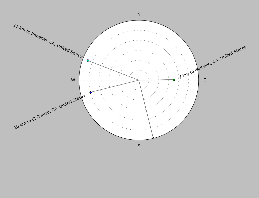
| ||||||||||||||||
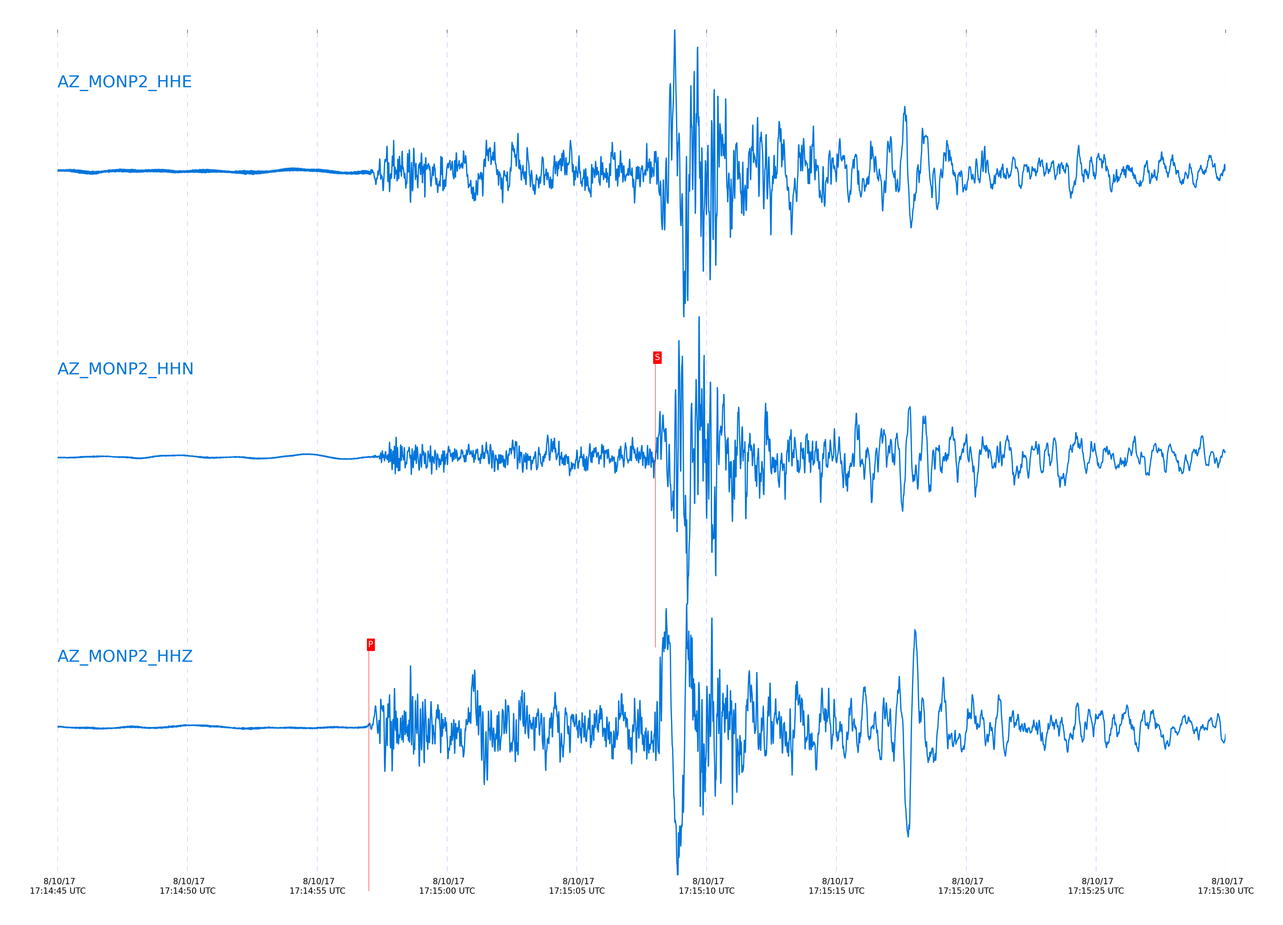
Event and active stations
|
|||||||||||||||||
Closest station with identified signal. Not filtered.
Subset of several stations close to the event. Not filtered.
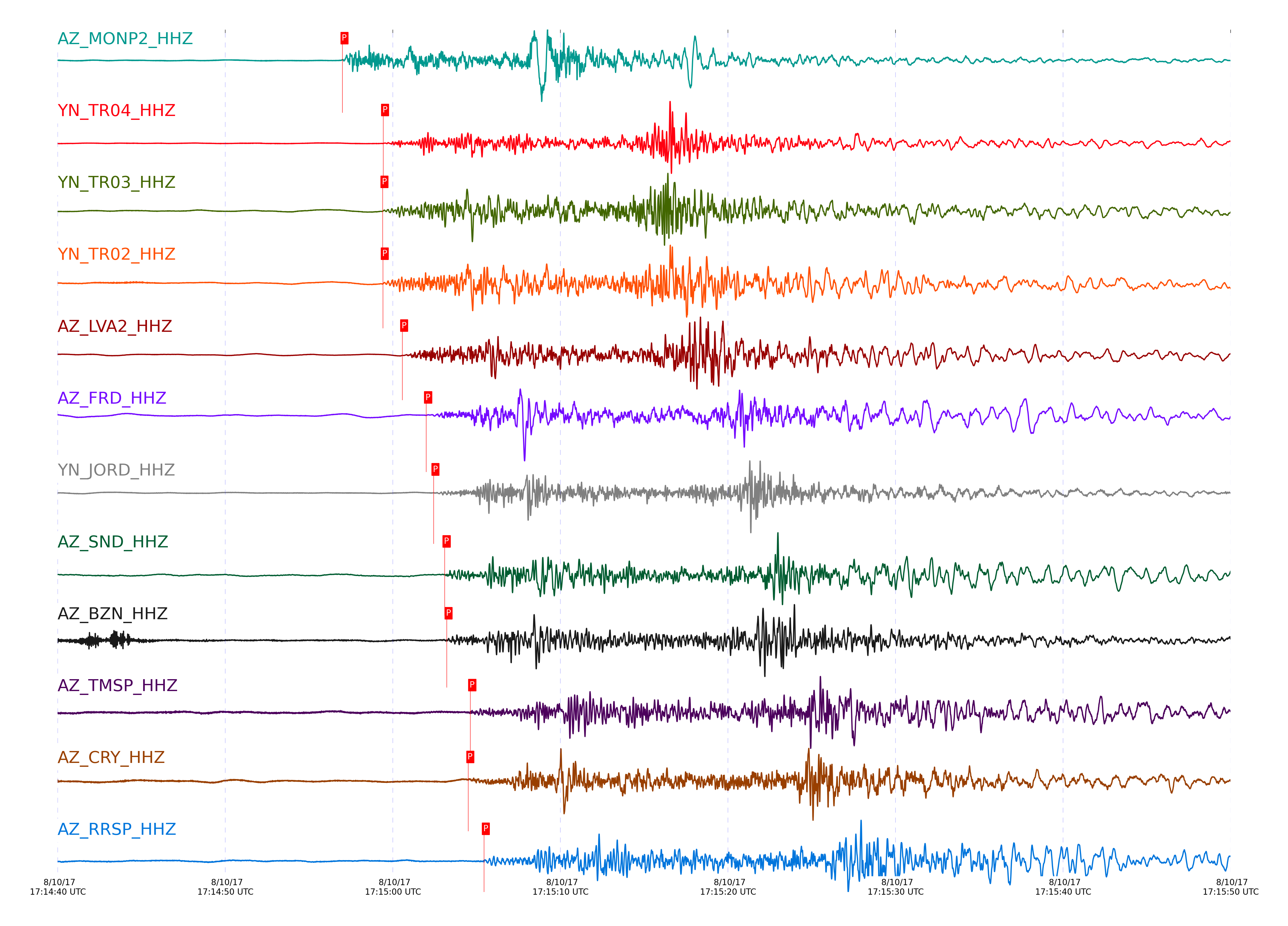
| STA_CHAN | S-E Delta | S-E Azimuth | Phase | Time | Signal/Noise | Time Residual | V. Model | Auth | arid |
|---|---|---|---|---|---|---|---|---|---|
| MONP2_HHZ | 0.812° | 95.53° | Pg | 2017-08-10 17:14:56.9907 UTC | 42.757 | -0.956 | iasp91 | dbp:jtytell:172 | 1479772 |
| MONP2_HHN | 0.812° | 95.53° | Sg | 2017-08-10 17:15:08.0214 UTC | -1 | -1.329 | iasp91 | dbp:jtytell:172 | 1480327 |
| TR04_HHZ | 1.001° | 125.78° | Pg | 2017-08-10 17:14:59.4175 UTC | -1 | -2.107 | iasp91 | dbp:jtytell:172 | 1480304 |
| TR03_HHZ | 1.005° | 126.36° | Pg | 2017-08-10 17:14:59.3828 UTC | -1 | -2.227 | iasp91 | dbp:jtytell:172 | 1480305 |
| TR03_HHN | 1.005° | 126.36° | Sg | 2017-08-10 17:15:14.7929 UTC | -1 | -0.878 | iasp91 | dbp:jtytell:172 | 1480331 |
| TR02_HHZ | 1.006° | 126.95° | Pg | 2017-08-10 17:14:59.4 UTC | -1 | -2.227 | iasp91 | dbp:jtytell:172 | 1480306 |
| TR02_HHN | 1.006° | 126.95° | Sg | 2017-08-10 17:15:14.909 UTC | -1 | -0.791 | iasp91 | dbp:jtytell:172 | 1480332 |
| LVA2_HHZ | 1.07° | 120.11° | Pb | 2017-08-10 17:15:00.5548 UTC | 97.759 | -2.167 | iasp91 | dbp:jtytell:172 | 1479773 |
| LVA2_HHN | 1.07° | 120.11° | Sb | 2017-08-10 17:15:15.3543 UTC | -1 | -2.302 | iasp91 | dbp:jtytell:172 | 1480335 |
| TRO_HHE | 1.078° | 131.17° | Sb | 2017-08-10 17:15:16.9606 UTC | -1 | -0.933 | iasp91 | dbp:jtytell:172 | 1480337 |
| PFO_HHN | 1.158° | 133.53° | Sb | 2017-08-10 17:15:19.1834 UTC | -1 | -1.083 | iasp91 | dbp:jtytell:172 | 1480346 |
| FRD_HHZ | 1.176° | 125.3° | Pb | 2017-08-10 17:15:01.9866 UTC | 60.103 | -2.543 | iasp91 | dbp:jtytell:172 | 1479777 |
| FRD_HHN | 1.176° | 125.3° | Sb | 2017-08-10 17:15:19.9268 UTC | -1 | -0.863 | iasp91 | dbp:jtytell:172 | 1480348 |
| JORD_HHZ | 1.193° | 123.4° | Pn | 2017-08-10 17:15:02.4271 UTC | 97.111 | -2.361 | iasp91 | dbp:jtytell:172 | 1479778 |
| JORD_HHN | 1.193° | 123.4° | Sb | 2017-08-10 17:15:20.5199 UTC | -1 | -0.765 | iasp91 | dbp:jtytell:172 | 1480350 |
| SND_HHZ | 1.217° | 127.25° | Pn | 2017-08-10 17:15:03.0884 UTC | 56.095 | -2.034 | iasp91 | dbp:jtytell:172 | 1479779 |
| BZN_HHZ | 1.219° | 123.67° | Pn | 2017-08-10 17:15:03.2098 UTC | 23.223 | -1.936 | iasp91 | dbp:jtytell:172 | 1479780 |
| WMC_HHN | 1.271° | 126.59° | Sb | 2017-08-10 17:15:20.3296 UTC | -1 | -3.275 | iasp91 | dbp:jtytell:172 | 1480353 |
| TMSP_HHZ | 1.303° | 128.06° | Pn | 2017-08-10 17:15:04.621 UTC | -1 | -1.683 | iasp91 | dbp:jtytell:172 | 1480314 |
| CRY_HHZ | 1.309° | 124.9° | Pn | 2017-08-10 17:15:04.5036 UTC | 22.804 | -1.88 | iasp91 | dbp:jtytell:172 | 1479781 |
| CRY_HHN | 1.309° | 124.9° | Sn | 2017-08-10 17:15:24.0579 UTC | -1 | -0.547 | iasp91 | dbp:jtytell:172 | 1480354 |
| GVAR1_HHN | 1.349° | 129.06° | Sn | 2017-08-10 17:15:25.3071 UTC | -1 | -0.295 | iasp91 | dbp:jtytell:172 | 1480359 |
| RRSP_HHZ | 1.361° | 127.83° | Pn | 2017-08-10 17:15:05.4304 UTC | -1 | -1.676 | iasp91 | dbp:jtytell:172 | 1480315 |
| RRSP_HHN | 1.361° | 127.83° | Sb | 2017-08-10 17:15:26.1143 UTC | -1 | -0.151 | iasp91 | dbp:jtytell:172 | 1480361 |
| KNW_HHN | 1.383° | 130.48° | Sn | 2017-08-10 17:15:26.0908 UTC | -1 | -0.351 | iasp91 | dbp:jtytell:172 | 1480365 |
| CPE_HHE | 1.384° | 92.82° | Sn | 2017-08-10 17:15:24.6837 UTC | -1 | -1.785 | iasp91 | dbp:jtytell:172 | 1480360 |
| RDM_HHN | 1.421° | 124.86° | Sn | 2017-08-10 17:15:27.2901 UTC | -1 | -0.096 | iasp91 | dbp:jtytell:172 | 1480366 |
Click the link below to observe an interactive map of earthquakes recorded by the station deployment:
Broadband Seismic Data Collection Center (ANZA),
Institute of Geophysics & Planetary Physics
Scripps Institution of Oceanography,
University of California San Diego
Copyright © 1989 - 2014. All Rights Reserved.