
last update to page: August 22 2017 23:18:37 (UTC).
SummaryThe red marker denotes the earthquake epicenter. On Tue Aug 22nd 2017 19:51:59 (UTC) the seismic network recorded an earthquake (preliminary 4.07 mw) located in Central California. Seismic region California - Nevada Region. The epicentral distance (i.e. distance separating the location to the epicenter) to the closest station WRDG in the network is 242.6 km. If you felt the quake, the USGS would like to know. Please add your comments to the USGS page "Did you feel it?". |
Details
Proximity to Population Centers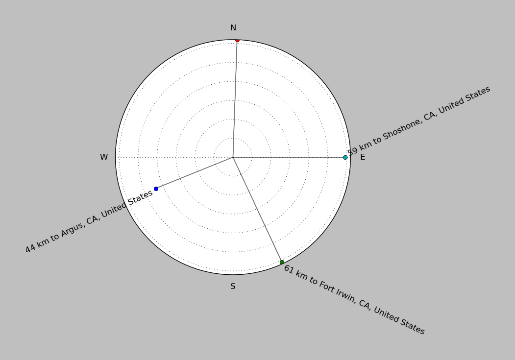
| ||||||||||||||||
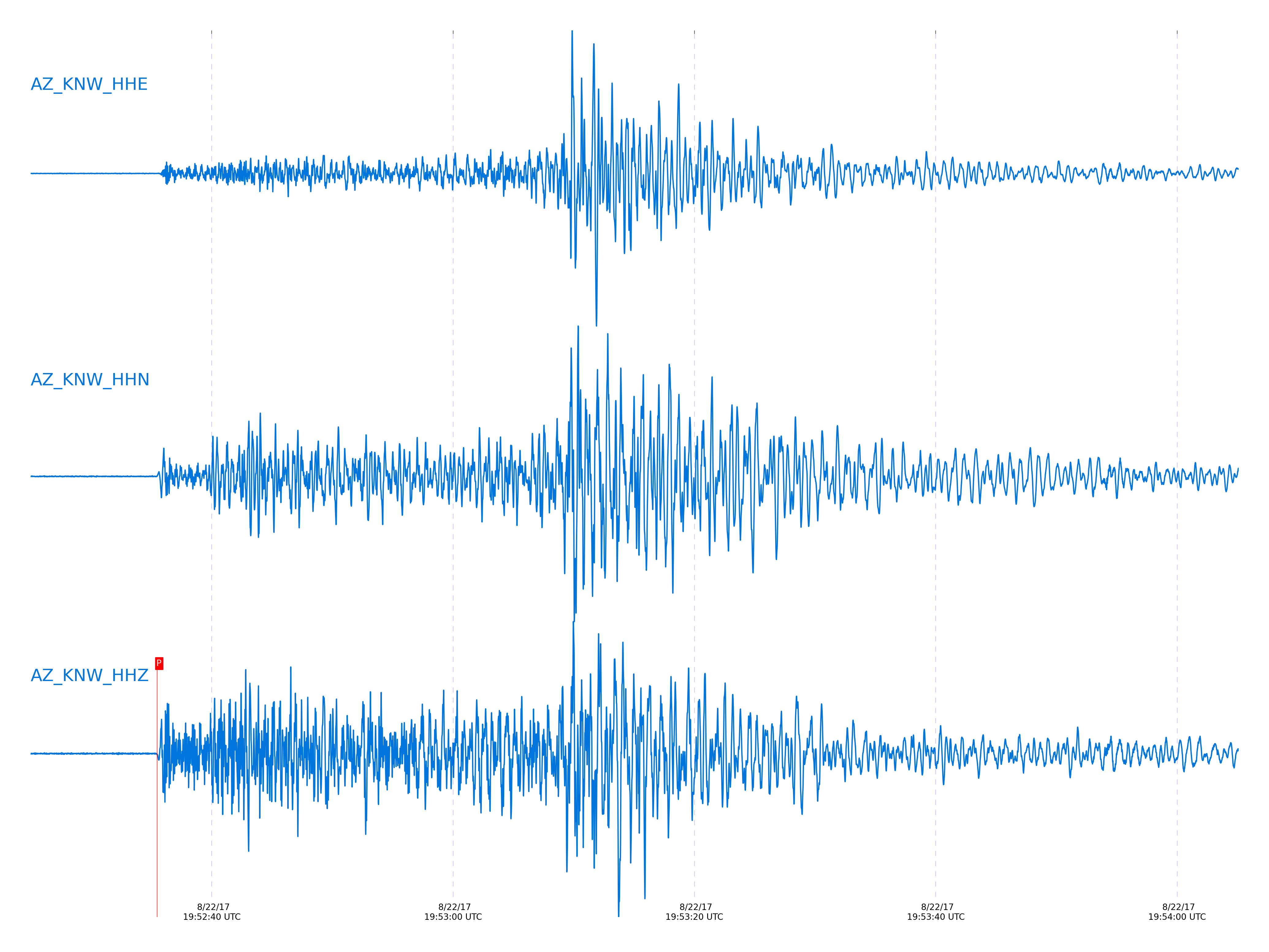
Event and active stations
|
|||||||||||||||||
Closest station with identified signal. 1 Hz highpass Butterworth filter has been applied to data.
Subset of several stations close to the event. 1 Hz highpass Butterworth filter has been applied to data.
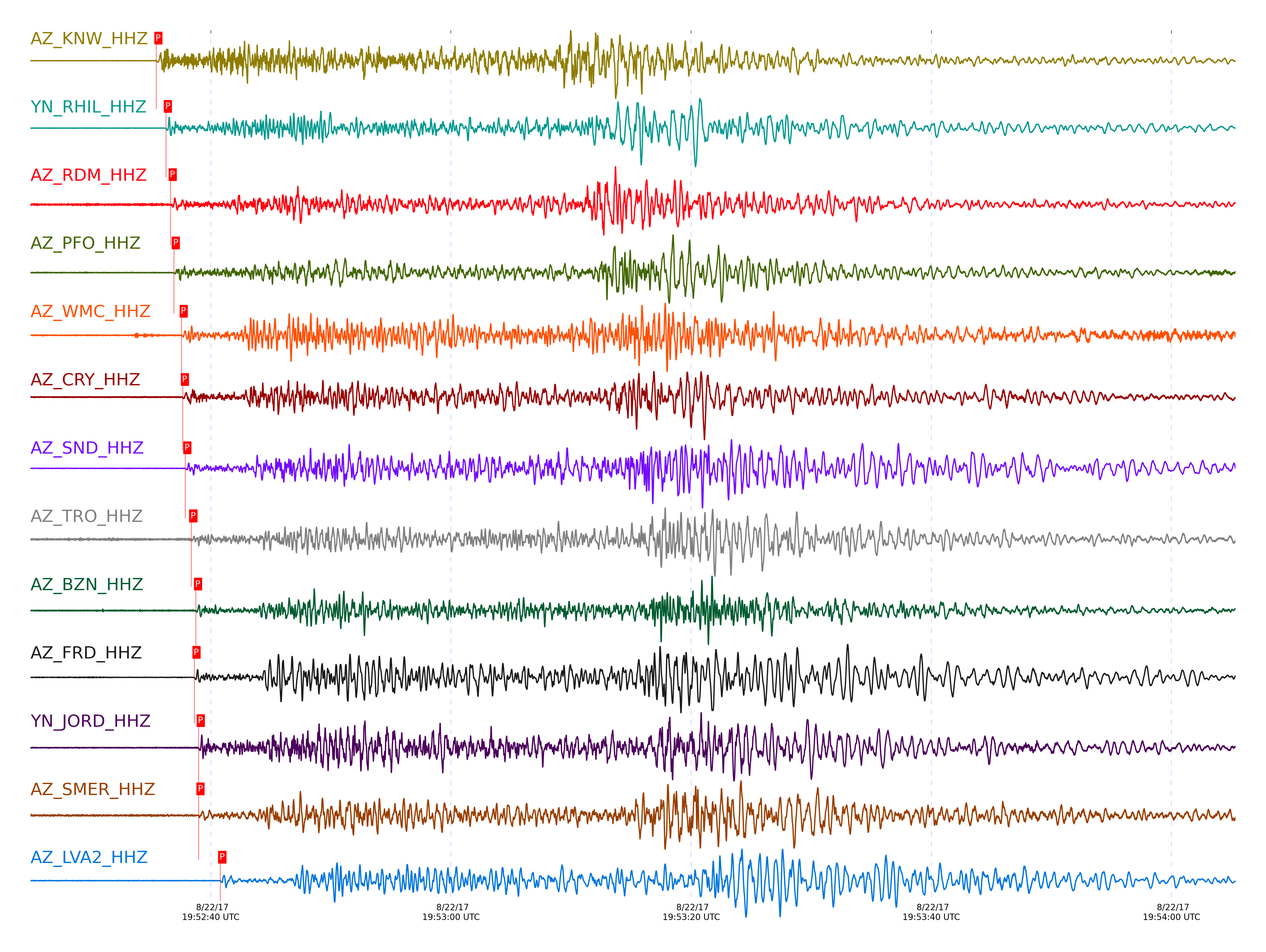
| STA_CHAN | S-E Delta | S-E Azimuth | Phase | Time | Signal/Noise | Time Residual | V. Model | Auth | arid |
|---|---|---|---|---|---|---|---|---|---|
| KNW_HHZ | 2.197° | 355.55° | Pn | 2017-08-22 19:52:35.4727 UTC | 71.414 | -0.976 | iasp91 | dbp:tcox:17234 | 1491282 |
| RHIL_HHZ | 2.235° | 356.86° | Pn | 2017-08-22 19:52:36.2633 UTC | -1 | -0.702 | iasp91 | dbp:tcox:17234 | 1491385 |
| RDM_HHZ | 2.275° | 358.48° | Pn | 2017-08-22 19:52:36.6594 UTC | 65.568 | -0.864 | iasp91 | dbp:tcox:17234 | 1491301 |
| PFO_HHZ | 2.324° | 350.71° | Pn | 2017-08-22 19:52:36.925 UTC | 18.046 | -1.269 | iasp91 | dbp:tcox:17234 | 1491284 |
| WMC_HHZ | 2.34° | 355.08° | Pn | 2017-08-22 19:52:37.5768 UTC | 34.17 | -0.833 | iasp91 | dbp:tcox:17234 | 1491310 |
| CRY_HHZ | 2.344° | 356.33° | Pn | 2017-08-22 19:52:37.673 UTC | 44.472 | -0.795 | iasp91 | dbp:tcox:17234 | 1491308 |
| SND_HHZ | 2.366° | 353.92° | Pn | 2017-08-22 19:52:37.8794 UTC | 30.441 | -0.895 | iasp91 | dbp:tcox:17234 | 1491285 |
| TRO_HHZ | 2.416° | 350.41° | Pn | 2017-08-22 19:52:38.3796 UTC | 56.242 | -1.076 | iasp91 | dbp:tcox:17234 | 1491315 |
| BZN_HHZ | 2.422° | 355.1° | Pn | 2017-08-22 19:52:38.7716 UTC | 7.7357 | -0.77 | iasp91 | dbp:tcox:17234 | 1491289 |
| FRD_HHZ | 2.424° | 353.86° | Pn | 2017-08-22 19:52:38.6434 UTC | 16.897 | -0.926 | iasp91 | dbp:tcox:17234 | 1491287 |
| JORD_HHZ | 2.443° | 354.72° | Pn | 2017-08-22 19:52:38.996 UTC | 26.07 | -0.833 | iasp91 | dbp:tcox:17234 | 1491290 |
| SMER_HHZ | 2.455° | 4.7° | Pn | 2017-08-22 19:52:38.985 UTC | 55.435 | -1.014 | iasp91 | dbp:tcox:17234 | 1491316 |
| LVA2_HHZ | 2.57° | 353.47° | Pn | 2017-08-22 19:52:40.7901 UTC | 17.879 | -0.787 | iasp91 | dbp:tcox:17234 | 1491291 |
Click the link below to observe an interactive map of earthquakes recorded by the station deployment:
Broadband Seismic Data Collection Center (ANZA),
Institute of Geophysics & Planetary Physics
Scripps Institution of Oceanography,
University of California San Diego
Copyright © 1989 - 2014. All Rights Reserved.