
last update to page: September 19 2017 17:54:52 (UTC).
SummaryThe red marker denotes the earthquake epicenter. On Tue Sep 19th 2017 06:20:44 (UTC) the seismic network recorded an earthquake (preliminary 3.61 ml) located in Southern California. Seismic region California - Nevada Region. The epicentral distance (i.e. distance separating the location to the epicenter) to the closest station CSLB in the network is 47.9 km. If you felt the quake, the USGS would like to know. Please add your comments to the USGS page "Did you feel it?". |
Details
Proximity to Population Centers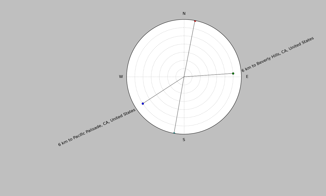
| ||||||||||||||||
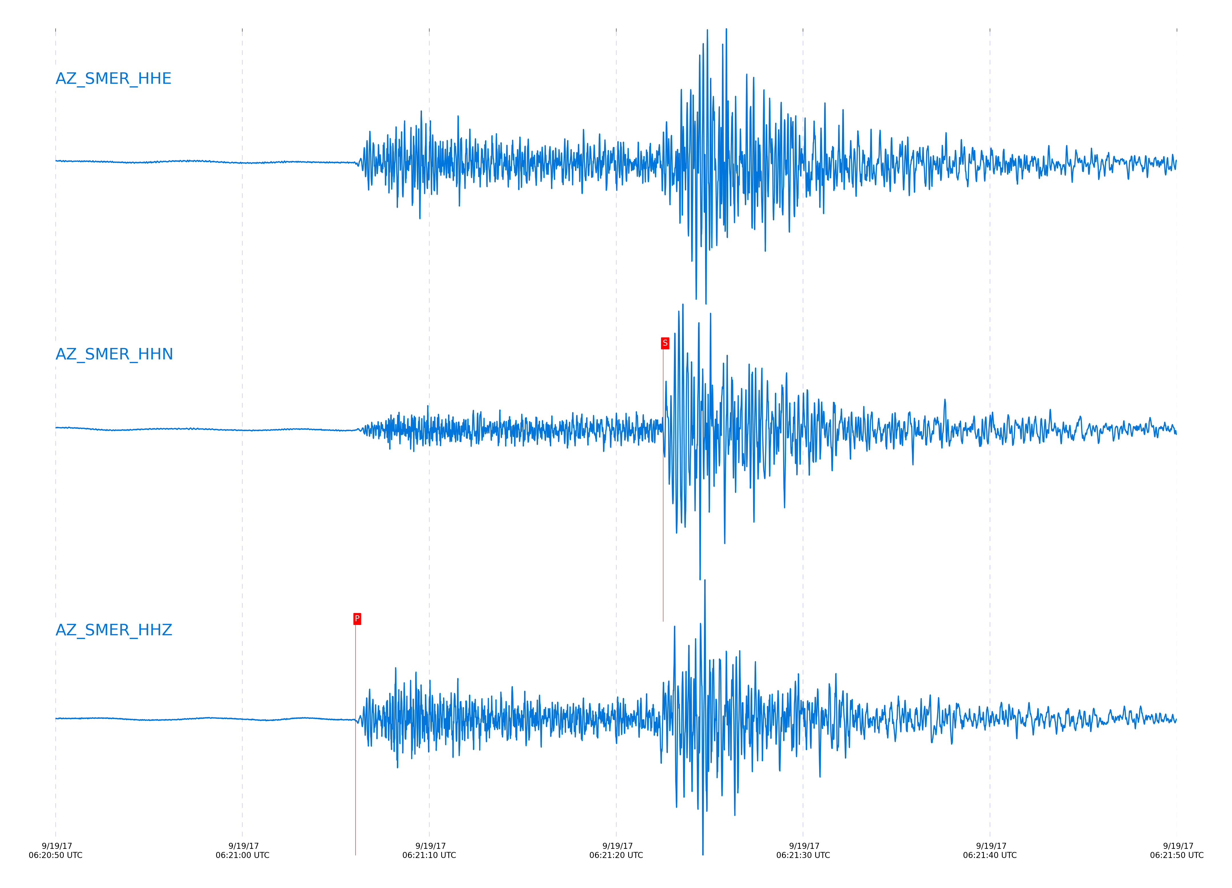
Event and active stations
|
|||||||||||||||||
Closest station with identified signal. Not filtered.
Subset of several stations close to the event. Not filtered.
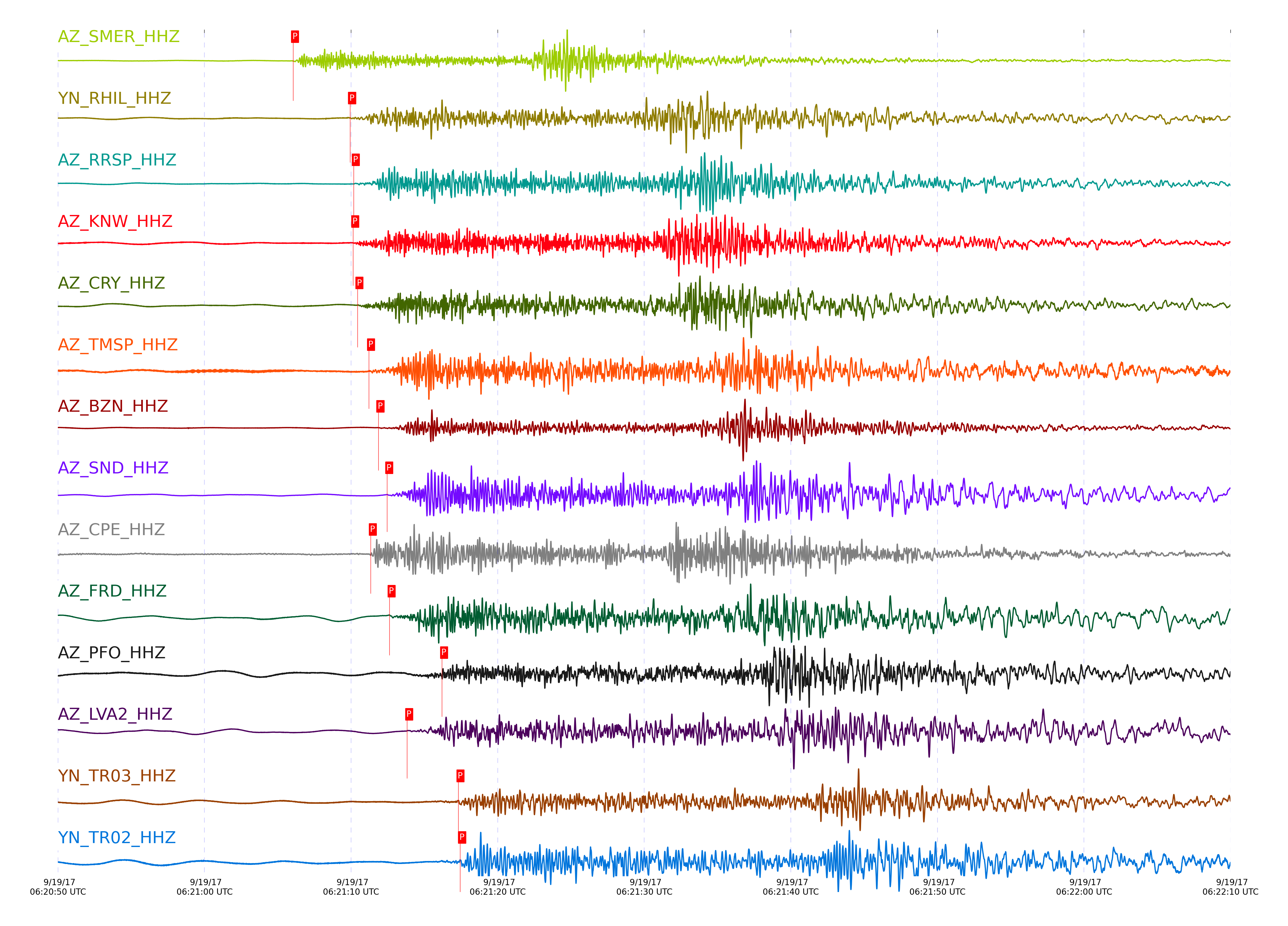
| STA_CHAN | S-E Delta | S-E Azimuth | Phase | Time | Signal/Noise | Time Residual | V. Model | Auth | arid |
|---|---|---|---|---|---|---|---|---|---|
| SMER_HHZ | 1.254° | 300.47° | Pn | 2017-09-19 06:21:06.0484 UTC | 130.6 | -1.829 | iasp91 | dbp:jtytell:172 | 1521221 |
| SMER_HHN | 1.254° | 300.47° | Sb | 2017-09-19 06:21:22.5116 UTC | -1 | -2.843 | iasp91 | dbp:jtytell:172 | 1521564 |
| RDM_HHN | 1.427° | 289.12° | Sn | 2017-09-19 06:21:28.9683 UTC | -1 | -0.889 | iasp91 | dbp:jtytell:172 | 1521573 |
| RHIL_HHZ | 1.474° | 286.76° | Pn | 2017-09-19 06:21:09.937 UTC | -1 | -0.97 | iasp91 | dbp:jtytell:172 | 1521534 |
| RHIL_HHN | 1.474° | 286.76° | Sn | 2017-09-19 06:21:30.5528 UTC | -1 | -0.474 | iasp91 | dbp:jtytell:172 | 1521574 |
| RRSP_HHZ | 1.506° | 287.28° | Pn | 2017-09-19 06:21:10.1941 UTC | -1 | -1.149 | iasp91 | dbp:jtytell:172 | 1521536 |
| KNW_HHZ | 1.511° | 284.77° | Pn | 2017-09-19 06:21:10.1478 UTC | 47.154 | -1.261 | iasp91 | dbp:jtytell:172 | 1521233 |
| GVAR1_HHN | 1.528° | 286.46° | Sn | 2017-09-19 06:21:31.8656 UTC | -1 | -0.487 | iasp91 | dbp:jtytell:172 | 1521571 |
| CRY_HHZ | 1.535° | 290.33° | Pn | 2017-09-19 06:21:10.4448 UTC | 108.9 | -1.303 | iasp91 | dbp:jtytell:172 | 1521222 |
| CRY_HHN | 1.535° | 290.33° | Sn | 2017-09-19 06:21:32.1392 UTC | -1 | -0.401 | iasp91 | dbp:jtytell:172 | 1521576 |
| TMSP_HHZ | 1.562° | 287.91° | Pn | 2017-09-19 06:21:11.2319 UTC | -1 | -0.884 | iasp91 | dbp:jtytell:172 | 1521539 |
| BZN_HHZ | 1.617° | 292.1° | Pn | 2017-09-19 06:21:11.8693 UTC | 114.9 | -0.998 | iasp91 | dbp:jtytell:172 | 1521229 |
| SND_HHZ | 1.637° | 289.58° | Pn | 2017-09-19 06:21:12.4684 UTC | 421 | -0.683 | iasp91 | dbp:jtytell:172 | 1521227 |
| JORD_HHE | 1.641° | 292.5° | Sn | 2017-09-19 06:21:35.458 UTC | -1 | 0.303 | iasp91 | dbp:jtytell:172 | 1521578 |
| CPE_HHZ | 1.656° | 316.72° | Pn | 2017-09-19 06:21:11.3484 UTC | 57.157 | -2.055 | iasp91 | dbp:jtytell:172 | 1521224 |
| FRD_HHZ | 1.666° | 291.34° | Pn | 2017-09-19 06:21:12.6299 UTC | 94.97 | -0.912 | iasp91 | dbp:jtytell:172 | 1521228 |
| PFO_HHZ | 1.741° | 286.4° | Pb | 2017-09-19 06:21:16.2116 UTC | 19.815 | -0.15 | iasp91 | dbp:jtytell:172 | 1521235 |
| LVA2_HHZ | 1.754° | 295.31° | Pn | 2017-09-19 06:21:13.8269 UTC | 128.01 | -0.924 | iasp91 | dbp:jtytell:172 | 1521231 |
| TR03_HHZ | 1.836° | 292.21° | Pb | 2017-09-19 06:21:17.3304 UTC | -1 | -0.657 | iasp91 | dbp:jtytell:172 | 1521551 |
| TR02_HHZ | 1.838° | 291.9° | Pb | 2017-09-19 06:21:17.4442 UTC | -1 | -0.573 | iasp91 | dbp:jtytell:172 | 1521552 |
Click the link below to observe an interactive map of earthquakes recorded by the station deployment:
Broadband Seismic Data Collection Center (ANZA),
Institute of Geophysics & Planetary Physics
Scripps Institution of Oceanography,
University of California San Diego
Copyright © 1989 - 2014. All Rights Reserved.