
last update to page: September 19 2017 19:59:23 (UTC).
SummaryThe red marker denotes the earthquake epicenter. On Tue Sep 19th 2017 18:45:43 (UTC) the seismic network recorded an earthquake (preliminary 3.65 ml) located in California-nevada Border Region. Seismic region California - Nevada Region. The epicentral distance (i.e. distance separating the location to the epicenter) to the closest station CSLB in the network is 251.2 km. If you felt the quake, the USGS would like to know. Please add your comments to the USGS page "Did you feel it?". |
Details
Proximity to Population Centers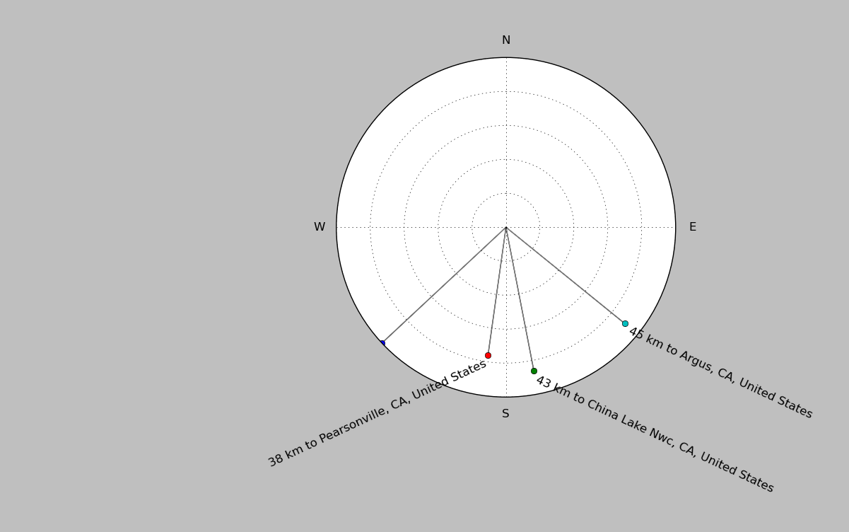
| ||||||||||||||||
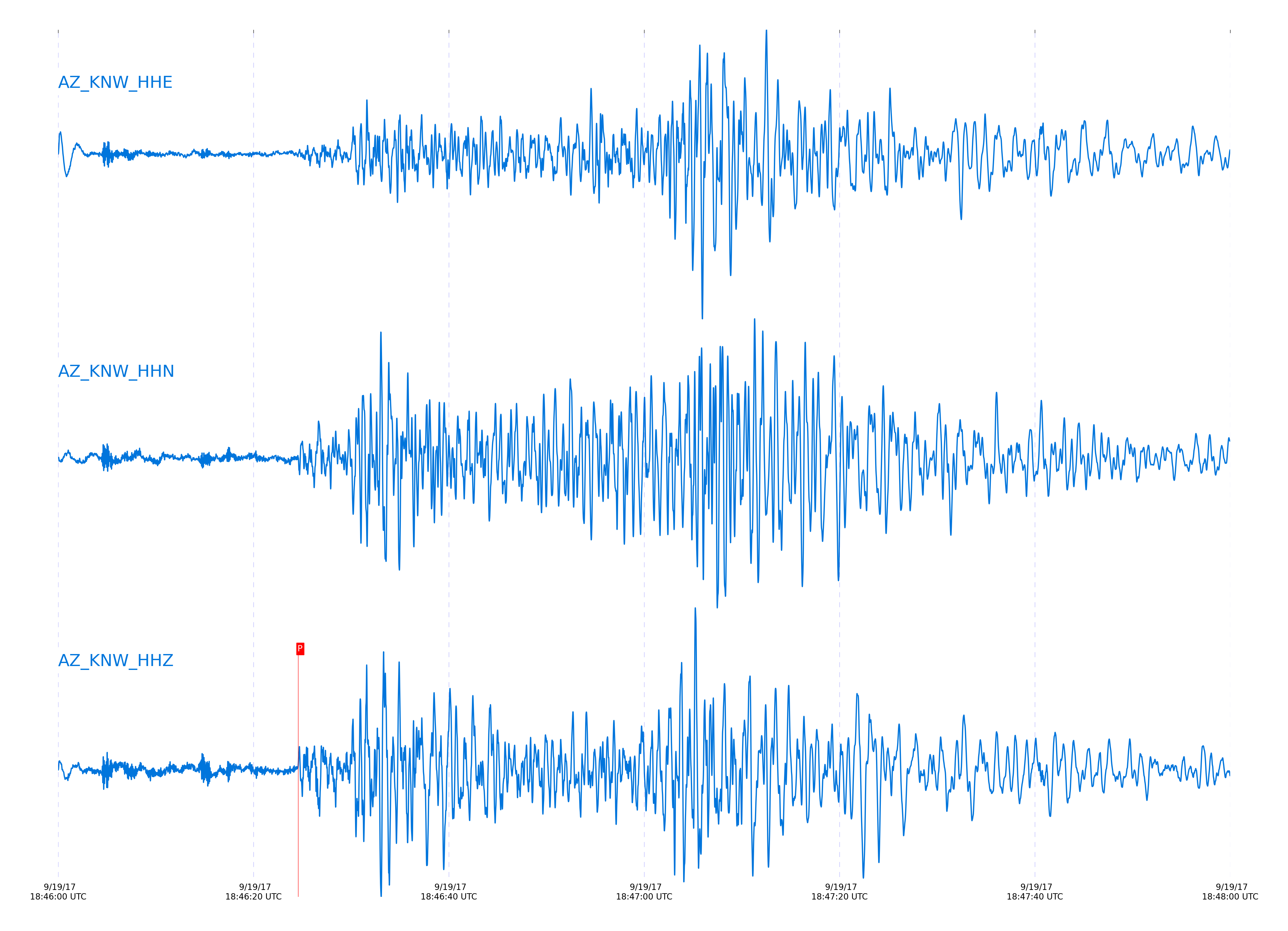
Event and active stations
|
|||||||||||||||||
Closest station with identified signal. 0.5 to 8 Hz bandpass Butterworth filter has been applied to data.
Subset of several stations close to the event. 0.5 to 8 Hz bandpass Butterworth filter has been applied to data.
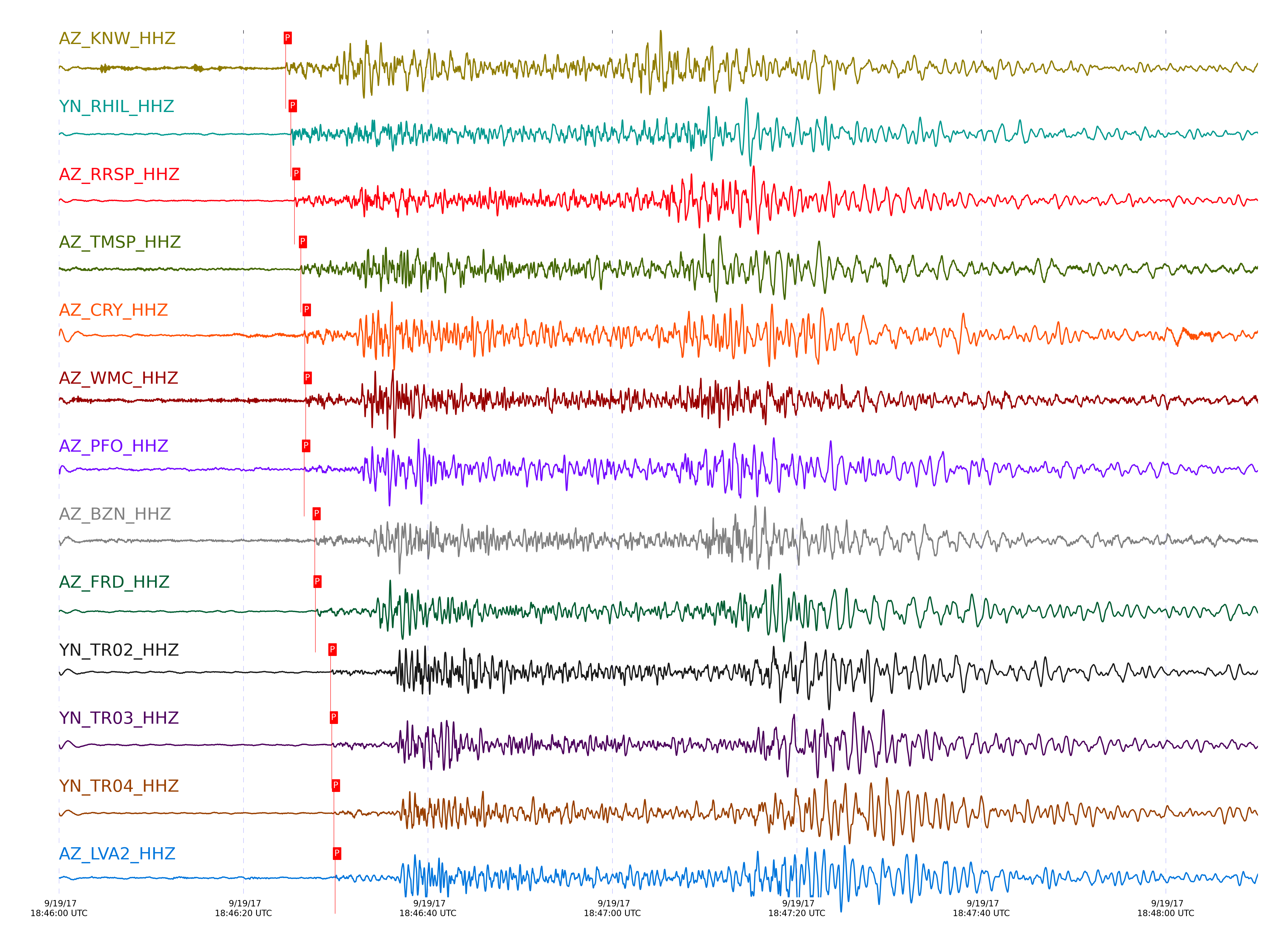
| STA_CHAN | S-E Delta | S-E Azimuth | Phase | Time | Signal/Noise | Time Residual | V. Model | Auth | arid |
|---|---|---|---|---|---|---|---|---|---|
| KNW_HHZ | 2.463° | 339.67° | Pn | 2017-09-19 18:46:24.5873 UTC | -1 | -0.375 | iasp91 | dbp:jtytell:172 | 1521857 |
| RHIL_HHZ | 2.485° | 341.03° | Pn | 2017-09-19 18:46:25.1436 UTC | -1 | -0.12 | iasp91 | dbp:jtytell:172 | 1521823 |
| RRSP_HHZ | 2.514° | 340.64° | Pn | 2017-09-19 18:46:25.5236 UTC | -1 | -0.142 | iasp91 | dbp:jtytell:172 | 1521825 |
| RRSP_HHE | 2.514° | 340.64° | Sb | 2017-09-19 18:47:04.0433 UTC | -1 | 0.865 | iasp91 | dbp:jtytell:172 | 1521852 |
| TMSP_HHZ | 2.561° | 339.88° | Pn | 2017-09-19 18:46:26.2323 UTC | -1 | -0.078 | iasp91 | dbp:jtytell:172 | 1521826 |
| CRY_HHZ | 2.596° | 341.23° | Pn | 2017-09-19 18:46:26.6522 UTC | -1 | -0.14 | iasp91 | dbp:jtytell:172 | 1521832 |
| CRY_HHN | 2.596° | 341.23° | Sb | 2017-09-19 18:47:05.8016 UTC | -1 | 0.201 | iasp91 | dbp:jtytell:172 | 1521853 |
| WMC_HHZ | 2.606° | 340.12° | Pn | 2017-09-19 18:46:26.7597 UTC | -1 | -0.164 | iasp91 | dbp:jtytell:172 | 1521829 |
| PFO_HHZ | 2.637° | 336.29° | Pn | 2017-09-19 18:46:26.5913 UTC | -1 | -0.761 | iasp91 | dbp:jtytell:172 | 1521854 |
| BZN_HHZ | 2.685° | 340.59° | Pn | 2017-09-19 18:46:27.7262 UTC | 8.1989 | -0.29 | iasp91 | dbp:jtytell:172 | 1521743 |
| FRD_HHZ | 2.701° | 339.53° | Pn | 2017-09-19 18:46:27.8125 UTC | 10.891 | -0.416 | iasp91 | dbp:jtytell:172 | 1521739 |
| TR02_HHZ | 2.829° | 337.23° | Pn | 2017-09-19 18:46:29.4478 UTC | -1 | -0.542 | iasp91 | dbp:jtytell:172 | 1521842 |
| TR03_HHZ | 2.835° | 337.4° | Pn | 2017-09-19 18:46:29.5893 UTC | -1 | -0.483 | iasp91 | dbp:jtytell:172 | 1521846 |
| TR04_HHZ | 2.844° | 337.52° | Pn | 2017-09-19 18:46:29.8204 UTC | -1 | -0.376 | iasp91 | dbp:jtytell:172 | 1521847 |
| LVA2_HHZ | 2.847° | 339.91° | Pn | 2017-09-19 18:46:29.9446 UTC | 7.7443 | -0.292 | iasp91 | dbp:jtytell:172 | 1521744 |
Click the link below to observe an interactive map of earthquakes recorded by the station deployment:
Broadband Seismic Data Collection Center (ANZA),
Institute of Geophysics & Planetary Physics
Scripps Institution of Oceanography,
University of California San Diego
Copyright © 1989 - 2014. All Rights Reserved.