
last update to page: September 22 2017 20:30:33 (UTC).
SummaryThe red marker denotes the earthquake epicenter. On Fri Sep 22nd 2017 19:50:16 (UTC) the seismic network recorded an earthquake (preliminary 5.7 mww) located in Off Coast Of Northern California. Seismic region California - Nevada Region. The epicentral distance (i.e. distance separating the location to the epicenter) to the closest station CSLB in the network is 1,060.5 km. If you felt the quake, the USGS would like to know. Please add your comments to the USGS page "Did you feel it?". |
Details
Proximity to Population Centers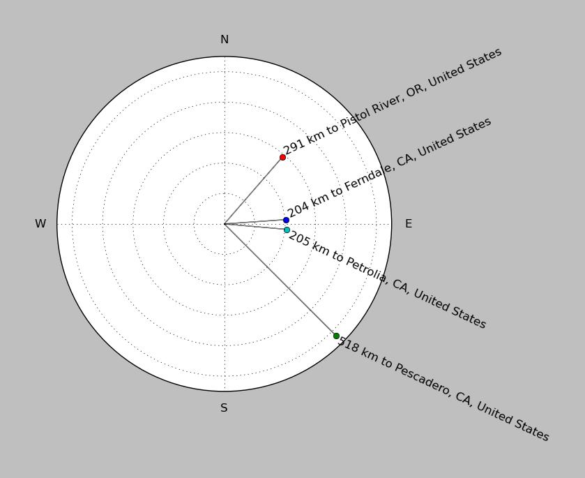
| ||||||||||||||||
Event and active stations
|
|||||||||||||||||
Closest station with identified signal. Not filtered.
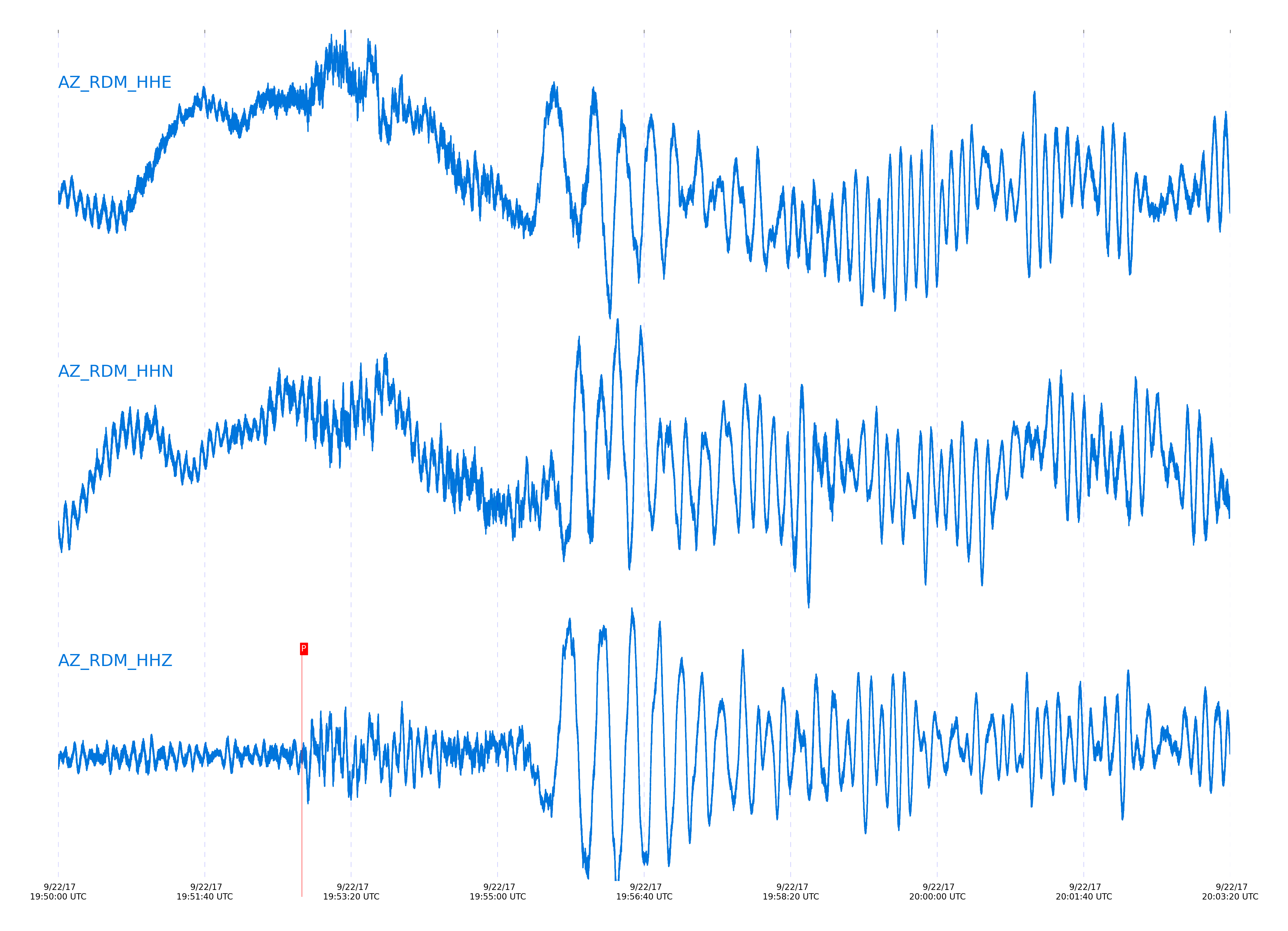
Subset of several stations close to the event. Not filtered.

| STA_CHAN | S-E Delta | S-E Azimuth | Phase | Time | Signal/Noise | Time Residual | V. Model | Auth | arid |
|---|---|---|---|---|---|---|---|---|---|
| RDM_HHZ | 10.373° | 313.87° | Pn | 2017-09-22 19:52:46.4291 UTC | 10.712 | 0.896 | iasp91 | dbp:jtytell:172 | 1524862 |
| RHIL_HHZ | 10.389° | 313.51° | pPn | 2017-09-22 19:52:47.1822 UTC | -1 | -0.764 | iasp91 | dbp:jtytell:172 | 1524899 |
| KNW_HHZ | 10.397° | 313.19° | Pn | 2017-09-22 19:52:46.3338 UTC | 8.1406 | 0.471 | iasp91 | dbp:jtytell:172 | 1524865 |
| RRSP_HHZ | 10.423° | 313.51° | Pn | 2017-09-22 19:52:46.8715 UTC | -1 | 0.648 | iasp91 | dbp:jtytell:172 | 1524903 |
| TMSP_HHZ | 10.48° | 313.49° | pPn | 2017-09-22 19:52:48.7221 UTC | -1 | -0.481 | iasp91 | dbp:jtytell:172 | 1524905 |
| CRY_HHZ | 10.484° | 313.84° | Pn | 2017-09-22 19:52:47.3844 UTC | 11.815 | 0.33 | iasp91 | dbp:jtytell:172 | 1524871 |
| WMC_HHZ | 10.516° | 313.65° | Pn | 2017-09-22 19:52:48.5309 UTC | 11.069 | 1.038 | iasp91 | dbp:jtytell:172 | 1524869 |
| SND_HHZ | 10.568° | 313.58° | Pn | 2017-09-22 19:52:49.0694 UTC | 8.2924 | 0.861 | iasp91 | dbp:jtytell:172 | 1524873 |
| BZN_HHZ | 10.577° | 313.95° | Pn | 2017-09-22 19:52:49.16 UTC | 9.265 | 0.825 | iasp91 | dbp:jtytell:172 | 1524867 |
| FRD_HHZ | 10.614° | 313.77° | Pn | 2017-09-22 19:52:49.4153 UTC | 7.0722 | 0.578 | iasp91 | dbp:jtytell:172 | 1524890 |
| PFO_HHZ | 10.62° | 312.96° | Pn | 2017-09-22 19:52:49.0749 UTC | -1 | 0.153 | iasp91 | dbp:jtytell:172 | 1524907 |
| LVA2_HHZ | 10.738° | 314.22° | Pn | 2017-09-22 19:52:51.1462 UTC | -1 | 0.613 | iasp91 | dbp:jtytell:172 | 1524913 |
| MONP2_HHZ | 11.145° | 315.55° | Pn | 2017-09-22 19:52:56.9644 UTC | 9.7062 | 0.861 | iasp91 | dbp:jtytell:172 | 1524879 |
Click the link below to observe an interactive map of earthquakes recorded by the station deployment:
Broadband Seismic Data Collection Center (ANZA),
Institute of Geophysics & Planetary Physics
Scripps Institution of Oceanography,
University of California San Diego
Copyright © 1989 - 2014. All Rights Reserved.