
last update to page: September 25 2017 17:57:59 (UTC).
SummaryThe red marker denotes the earthquake epicenter. On Sat Sep 23rd 2017 12:53:02 (UTC) the seismic network recorded an earthquake (preliminary 6.1 mww) located in Oaxaca, Mexico. Seismic region Mexico - Guatemala Area. The epicentral distance (i.e. distance separating the location to the epicenter) to the closest station USGCB in the network is 2,790.5 km. If you felt the quake, the USGS would like to know. Please add your comments to the USGS page "Did you feel it?". |
Details
Proximity to Population Centers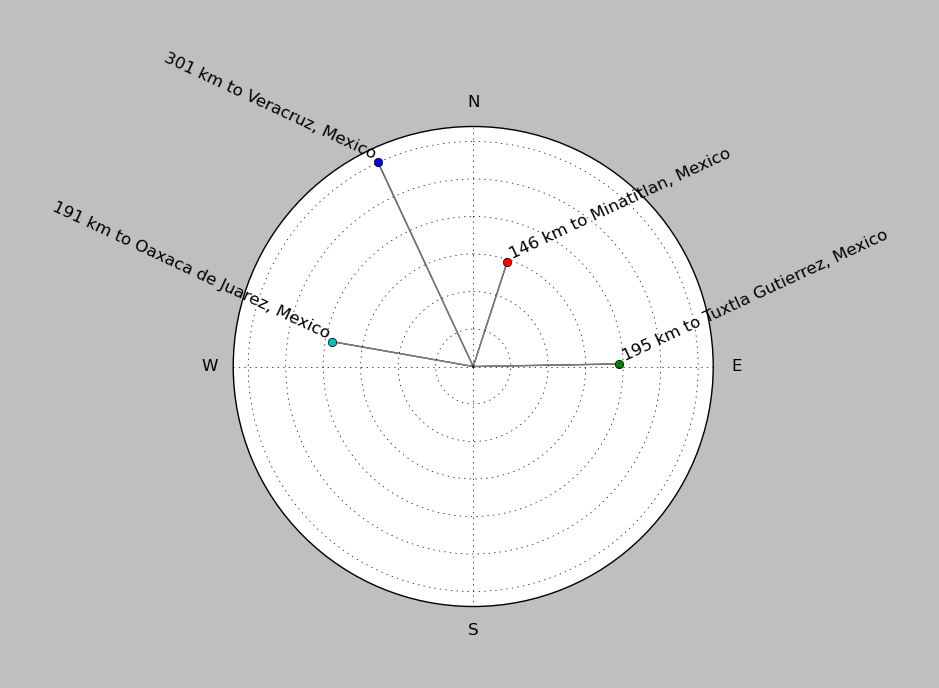
| ||||||||||||||||
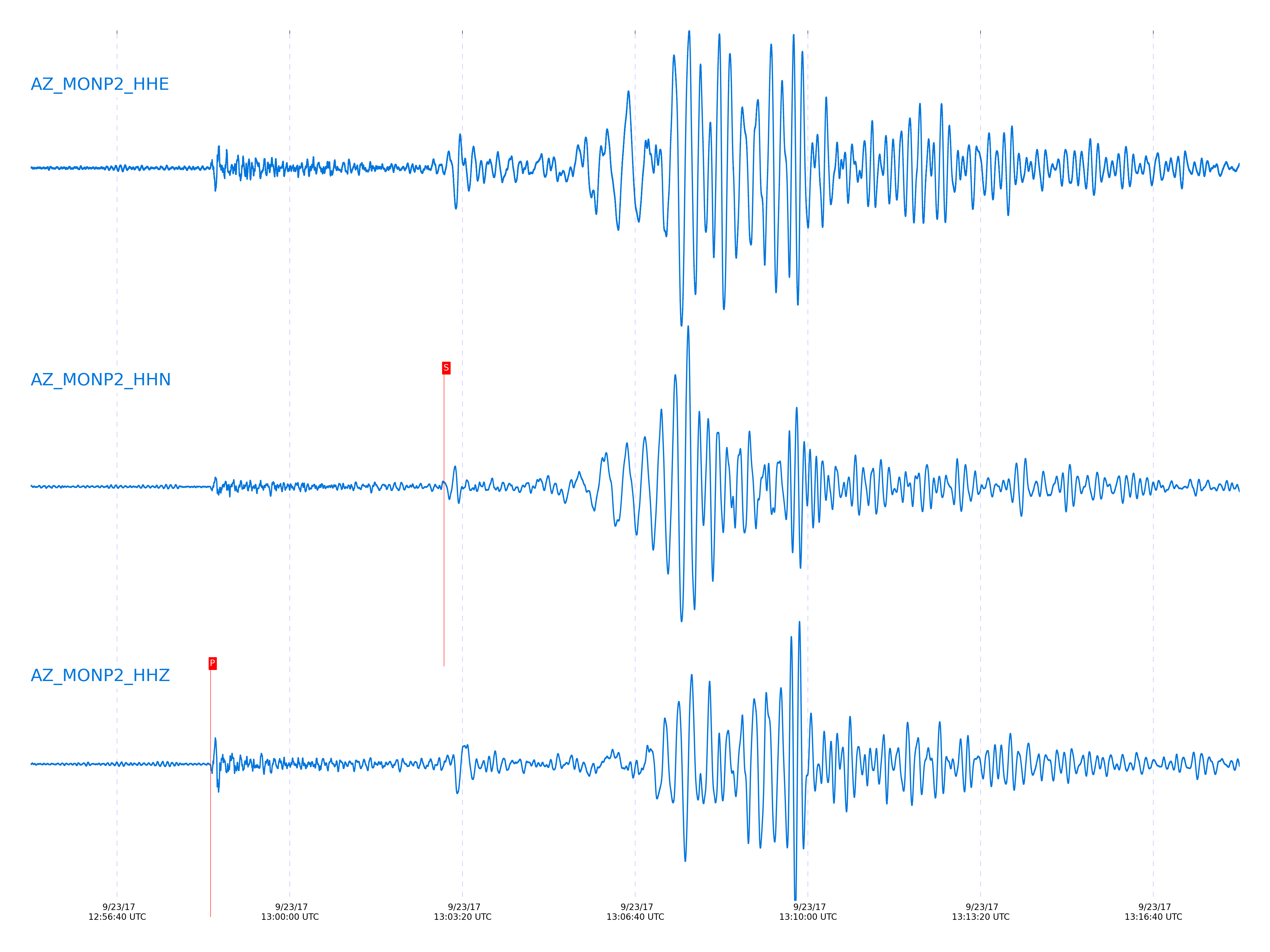
Event and active stations
|
|||||||||||||||||
Closest station with identified signal. Not filtered.
Subset of several stations close to the event. Not filtered.
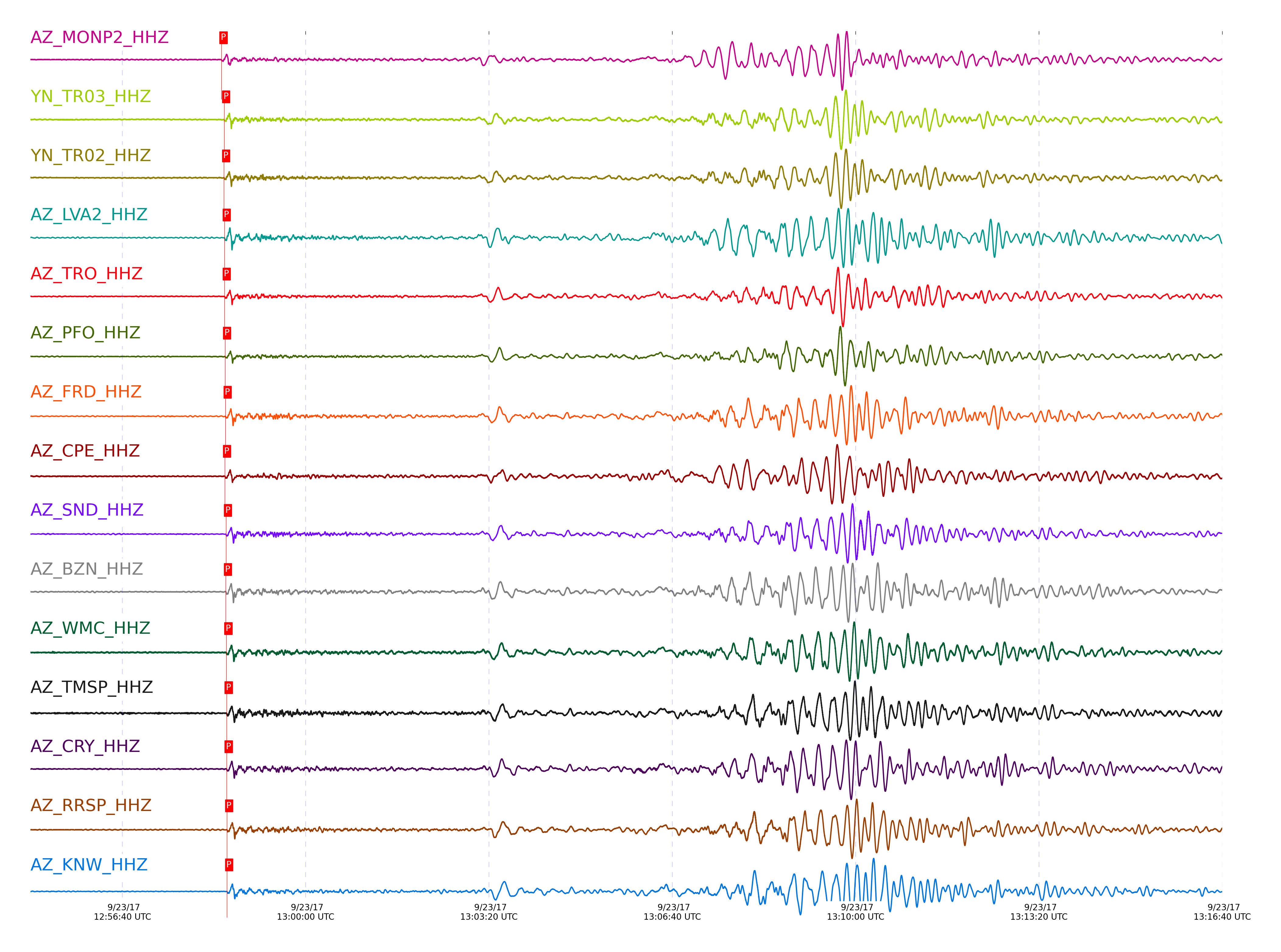
| STA_CHAN | S-E Delta | S-E Azimuth | Phase | Time | Signal/Noise | Time Residual | V. Model | Auth | arid |
|---|---|---|---|---|---|---|---|---|---|
| MONP2_HHZ | 25.22° | 124.63° | P | 2017-09-23 12:58:28.2504 UTC | -1 | -0.05 | iasp91 | dbp:jtytell:172 | 1526951 |
| MONP2_HHN | 25.22° | 124.63° | S | 2017-09-23 13:02:58.6369 UTC | -1 | -3.157 | iasp91 | dbp:jtytell:172 | 1527045 |
| TR03_HHZ | 25.518° | 125.52° | P | 2017-09-23 12:58:31.1532 UTC | -1 | 0.146 | iasp91 | dbp:jtytell:172 | 1526960 |
| TR03_HHE | 25.518° | 125.52° | S | 2017-09-23 13:03:05.5212 UTC | -1 | -1.763 | iasp91 | dbp:jtytell:172 | 1527053 |
| TR02_HHZ | 25.519° | 125.55° | P | 2017-09-23 12:58:31.0999 UTC | -1 | 0.086 | iasp91 | dbp:jtytell:172 | 1526961 |
| TR02_HHE | 25.519° | 125.55° | S | 2017-09-23 13:03:05.2292 UTC | -1 | -2.068 | iasp91 | dbp:jtytell:172 | 1527052 |
| LVA2_HHZ | 25.578° | 125.21° | P | 2017-09-23 12:58:31.7628 UTC | 77.479 | 0.206 | iasp91 | dbp:jtytell:172 | 1525402 |
| LVA2_HHE | 25.578° | 125.21° | S | 2017-09-23 13:03:04.2808 UTC | -1 | 3.755 | iasp91 | dbp:jtytell:172 | 1527054 |
| TRO_HHZ | 25.586° | 125.71° | P | 2017-09-23 12:58:31.7401 UTC | 99.513 | 0.116 | iasp91 | dbp:jtytell:172 | 1525400 |
| TRO_HHE | 25.586° | 125.71° | S | 2017-09-23 13:03:06.4362 UTC | -1 | -2.095 | iasp91 | dbp:jtytell:172 | 1527055 |
| PFO_HHZ | 25.66° | 125.81° | P | 2017-09-23 12:58:32.1462 UTC | 87.712 | -0.153 | iasp91 | dbp:jtytell:172 | 1525404 |
| PFO_HHE | 25.66° | 125.81° | S | 2017-09-23 13:03:06.5143 UTC | -1 | -3.38 | iasp91 | dbp:jtytell:172 | 1527062 |
| FRD_HHZ | 25.689° | 125.39° | P | 2017-09-23 12:58:32.7345 UTC | 74.354 | 0.176 | iasp91 | dbp:jtytell:172 | 1525408 |
| FRD_HHE | 25.689° | 125.39° | S | 2017-09-23 13:03:08.5644 UTC | -1 | -1.855 | iasp91 | dbp:jtytell:172 | 1527064 |
| CPE_HHZ | 25.693° | 123.58° | P | 2017-09-23 12:58:32.0536 UTC | 28.962 | -0.541 | iasp91 | dbp:jtytell:172 | 1525411 |
| CPE_HHE | 25.693° | 123.58° | S | 2017-09-23 13:03:05.9147 UTC | -1 | 3.578 | iasp91 | dbp:jtytell:172 | 1527065 |
| JORD_HHE | 25.705° | 125.28° | S | 2017-09-23 13:03:06.9202 UTC | -1 | -3.794 | iasp91 | dbp:jtytell:172 | 1527066 |
| SND_HHZ | 25.729° | 125.47° | P | 2017-09-23 12:58:33.1309 UTC | 47.435 | 0.206 | iasp91 | dbp:jtytell:172 | 1525417 |
| SND_HHE | 25.729° | 125.47° | S | 2017-09-23 13:03:11.3179 UTC | -1 | 0.159 | iasp91 | dbp:jtytell:172 | 1527068 |
| BZN_HHZ | 25.731° | 125.28° | P | 2017-09-23 12:58:33.0875 UTC | 97.429 | 0.146 | iasp91 | dbp:jtytell:172 | 1525412 |
| BZN_HHE | 25.731° | 125.28° | S | 2017-09-23 13:03:08.3506 UTC | -1 | -2.841 | iasp91 | dbp:jtytell:172 | 1527069 |
| SIO5_HHZ | 25.768° | 123.28° | P | 2017-09-23 12:58:33.0602 UTC | 19.789 | -0.212 | iasp91 | dbp:jtytell:172 | 1525413 |
| WMC_HHZ | 25.784° | 125.41° | P | 2017-09-23 12:58:33.5656 UTC | 58.176 | 0.146 | iasp91 | dbp:jtytell:172 | 1525410 |
| WMC_HHE | 25.784° | 125.41° | S | 2017-09-23 13:03:09.127 UTC | -1 | -3.029 | iasp91 | dbp:jtytell:172 | 1527073 |
| TMSP_HHZ | 25.814° | 125.48° | P | 2017-09-23 12:58:33.9627 UTC | -1 | 0.265 | iasp91 | dbp:jtytell:172 | 1526972 |
| TMSP_HHE | 25.814° | 125.48° | S | 2017-09-23 13:03:10.5982 UTC | -1 | -2.117 | iasp91 | dbp:jtytell:172 | 1527072 |
| CRY_HHZ | 25.822° | 125.3° | P | 2017-09-23 12:58:33.9081 UTC | 64.349 | 0.146 | iasp91 | dbp:jtytell:172 | 1525414 |
| CRY_HHE | 25.822° | 125.3° | S | 2017-09-23 13:03:10.3646 UTC | -1 | -2.481 | iasp91 | dbp:jtytell:172 | 1527075 |
| GVAR1_HHN | 25.859° | 125.51° | S | 2017-09-23 13:03:10.7055 UTC | -1 | -2.827 | iasp91 | dbp:jtytell:172 | 1527077 |
| RRSP_HHZ | 25.873° | 125.44° | P | 2017-09-23 12:58:34.3726 UTC | -1 | 0.146 | iasp91 | dbp:jtytell:172 | 1526975 |
| RRSP_HHE | 25.873° | 125.44° | S | 2017-09-23 13:03:11.7242 UTC | -1 | -2.057 | iasp91 | dbp:jtytell:172 | 1527078 |
| KNW_HHZ | 25.891° | 125.59° | P | 2017-09-23 12:58:34.3243 UTC | 88.279 | -0.063 | iasp91 | dbp:jtytell:172 | 1525416 |
| KNW_HHE | 25.891° | 125.59° | S | 2017-09-23 13:03:10.6914 UTC | -1 | -3.413 | iasp91 | dbp:jtytell:172 | 1527079 |
| RHIL_HHZ | 25.907° | 125.43° | P | 2017-09-23 12:58:34.7721 UTC | -1 | 0.236 | iasp91 | dbp:jtytell:172 | 1526977 |
| RHIL_HHE | 25.907° | 125.43° | S | 2017-09-23 13:03:11.4374 UTC | -1 | -2.968 | iasp91 | dbp:jtytell:172 | 1527080 |
| RDM_HHZ | 25.934° | 125.24° | P | 2017-09-23 12:58:34.8372 UTC | 82.825 | 0.056 | iasp91 | dbp:jtytell:172 | 1525418 |
| RDM_HHE | 25.934° | 125.24° | S | 2017-09-23 13:03:11.6817 UTC | -1 | -3.215 | iasp91 | dbp:jtytell:172 | 1527082 |
| SMER_HHZ | 26.057° | 124.45° | P | 2017-09-23 12:58:35.4688 UTC | -1 | -0.421 | iasp91 | dbp:jtytell:172 | 1526982 |
| SMER_HHN | 26.057° | 124.45° | S | 2017-09-23 13:03:13.3876 UTC | -1 | -3.737 | iasp91 | dbp:jtytell:172 | 1527086 |
Click the link below to observe an interactive map of earthquakes recorded by the station deployment:
Broadband Seismic Data Collection Center (ANZA),
Institute of Geophysics & Planetary Physics
Scripps Institution of Oceanography,
University of California San Diego
Copyright © 1989 - 2014. All Rights Reserved.