
last update to page: October 09 2017 15:14:13 (UTC).
SummaryThe red marker denotes the earthquake epicenter. On Sun Oct 8th 2017 22:34:33 (UTC) the seismic network recorded an earthquake (preliminary 6.6 mww) located in Rat Islands, Aleutian Islands. Seismic region Alaska - Aleutian Arc. The epicentral distance (i.e. distance separating the location to the epicenter) to the closest station CSLB in the network is 5,469.9 km. If you felt the quake, the USGS would like to know. Please add your comments to the USGS page "Did you feel it?". |
Details
Proximity to Population Centers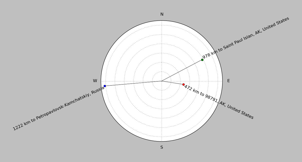
| ||||||||||||||||
Event and active stations
|
|||||||||||||||||
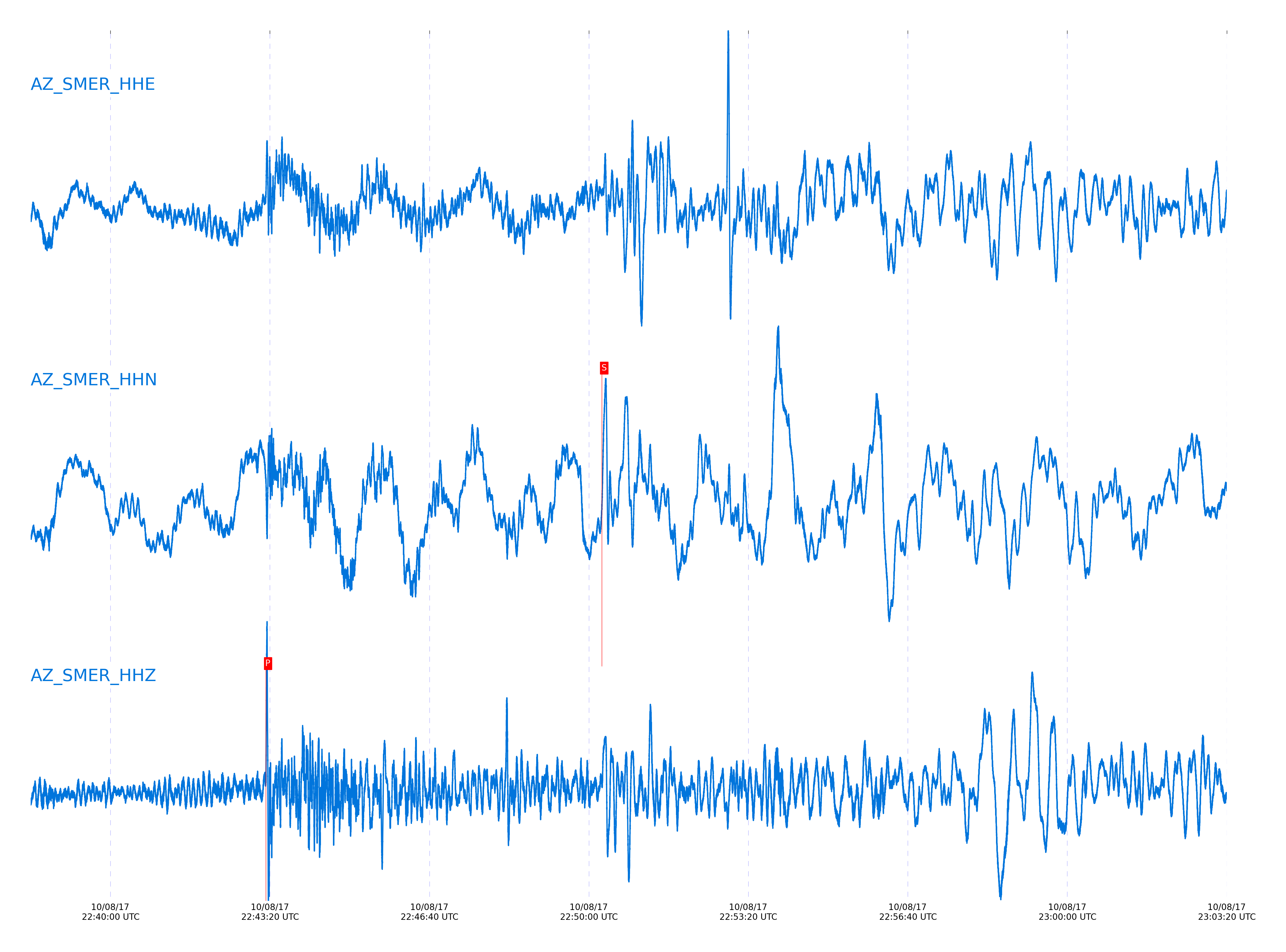
Closest station with identified signal. Not filtered.
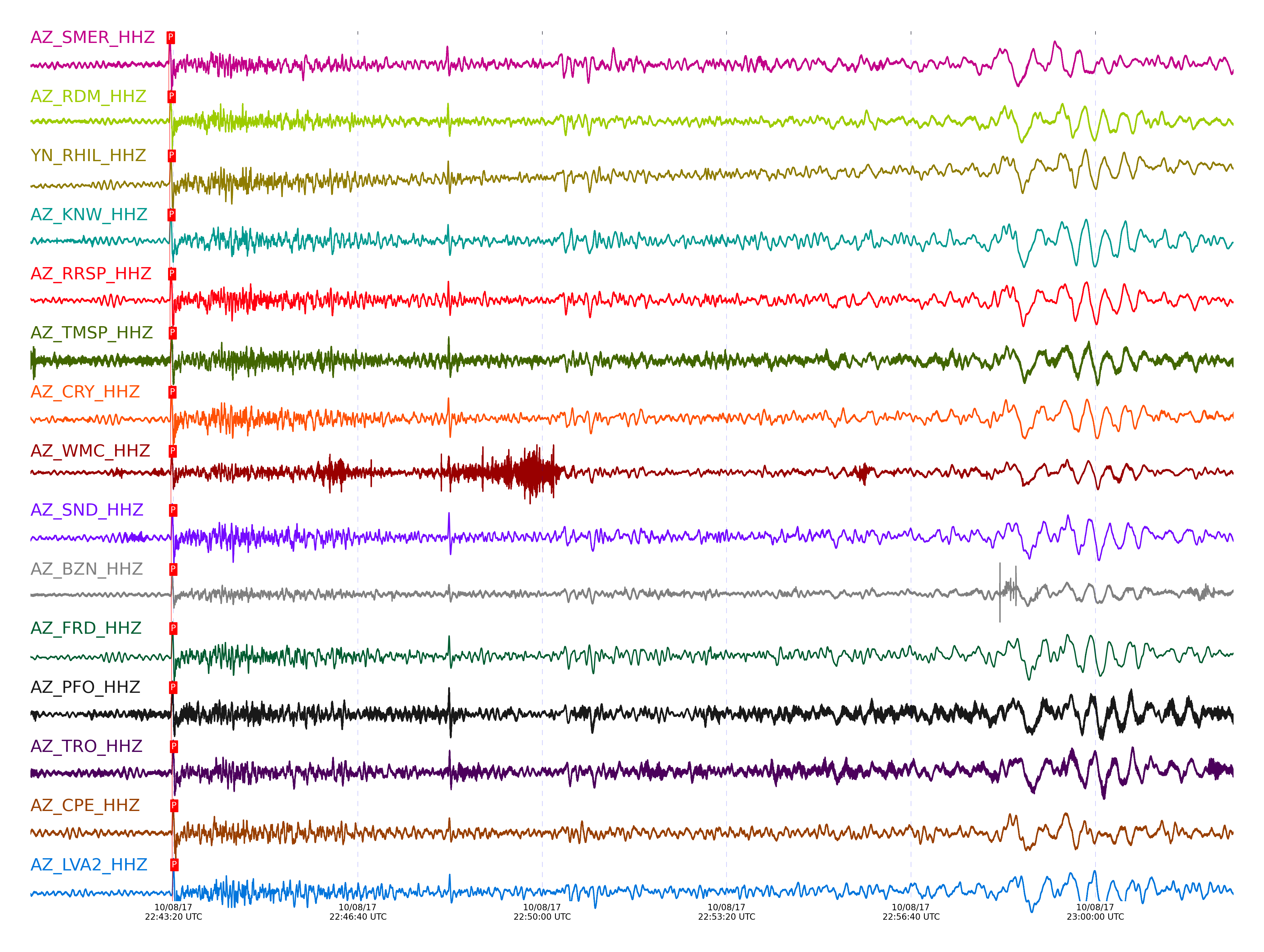
Subset of several stations close to the event. Not filtered.
| STA_CHAN | S-E Delta | S-E Azimuth | Phase | Time | Signal/Noise | Time Residual | V. Model | Auth | arid |
|---|---|---|---|---|---|---|---|---|---|
| SMER_HHZ | 49.929° | 313.31° | P | 2017-10-08 22:43:14.9313 UTC | -1 | -1.199 | iasp91 | dbp:jtytell:172 | 1542850 |
| SMER_HHN | 49.929° | 313.31° | S | 2017-10-08 22:50:16.4095 UTC | -1 | -2.066 | iasp91 | dbp:jtytell:172 | 1542905 |
| RDM_HHZ | 50.007° | 313.23° | P | 2017-10-08 22:43:15.8633 UTC | 50.688 | -0.856 | iasp91 | dbp:jtytell:172 | 1542220 |
| RDM_HHN | 50.007° | 313.23° | S | 2017-10-08 22:50:17.3633 UTC | -1 | -2.196 | iasp91 | dbp:jtytell:172 | 1542903 |
| RHIL_HHZ | 50.024° | 313.2° | P | 2017-10-08 22:43:16.0639 UTC | -1 | -0.783 | iasp91 | dbp:jtytell:172 | 1542851 |
| RHIL_HHN | 50.024° | 313.2° | S | 2017-10-08 22:50:19.6775 UTC | -1 | -0.115 | iasp91 | dbp:jtytell:172 | 1542904 |
| KNW_HHZ | 50.032° | 313.18° | P | 2017-10-08 22:43:15.8064 UTC | 25.021 | -1.101 | iasp91 | dbp:jtytell:172 | 1542222 |
| KNW_HHN | 50.032° | 313.18° | S | 2017-10-08 22:50:17.7942 UTC | -1 | -2.111 | iasp91 | dbp:jtytell:172 | 1542906 |
| RRSP_HHZ | 50.058° | 313.22° | P | 2017-10-08 22:43:16.2979 UTC | -1 | -0.807 | iasp91 | dbp:jtytell:172 | 1542855 |
| RRSP_HHN | 50.058° | 313.22° | S | 2017-10-08 22:50:18.8425 UTC | -1 | -1.426 | iasp91 | dbp:jtytell:172 | 1542907 |
| TMSP_HHZ | 50.116° | 313.24° | P | 2017-10-08 22:43:16.9534 UTC | -1 | -0.587 | iasp91 | dbp:jtytell:172 | 1542859 |
| TMSP_HHN | 50.116° | 313.24° | S | 2017-10-08 22:50:19.5205 UTC | -1 | -1.548 | iasp91 | dbp:jtytell:172 | 1542910 |
| CRY_HHZ | 50.118° | 313.27° | P | 2017-10-08 22:43:16.8265 UTC | 76.859 | -0.734 | iasp91 | dbp:jtytell:172 | 1542226 |
| CRY_HHN | 50.118° | 313.27° | S | 2017-10-08 22:50:20.0266 UTC | -1 | -1.079 | iasp91 | dbp:jtytell:172 | 1542911 |
| WMC_HHZ | 50.151° | 313.27° | P | 2017-10-08 22:43:17.0707 UTC | 46.27 | -0.734 | iasp91 | dbp:jtytell:172 | 1542232 |
| SND_HHZ | 50.203° | 313.29° | P | 2017-10-08 22:43:17.5393 UTC | 21.514 | -0.66 | iasp91 | dbp:jtytell:172 | 1542230 |
| SND_HHN | 50.203° | 313.29° | S | 2017-10-08 22:50:21.0305 UTC | -1 | -1.251 | iasp91 | dbp:jtytell:172 | 1542915 |
| BZN_HHZ | 50.212° | 313.32° | P | 2017-10-08 22:43:17.5798 UTC | 31.258 | -0.685 | iasp91 | dbp:jtytell:172 | 1542228 |
| BZN_HHN | 50.212° | 313.32° | S | 2017-10-08 22:50:20.7309 UTC | -1 | -1.67 | iasp91 | dbp:jtytell:172 | 1542916 |
| JORD_HHN | 50.238° | 313.34° | S | 2017-10-08 22:50:20.6885 UTC | -1 | -2.081 | iasp91 | dbp:jtytell:172 | 1542917 |
| FRD_HHZ | 50.249° | 313.33° | P | 2017-10-08 22:43:17.8107 UTC | 28.98 | -0.734 | iasp91 | dbp:jtytell:172 | 1542234 |
| FRD_HHN | 50.249° | 313.33° | S | 2017-10-08 22:50:21.0108 UTC | -1 | -1.905 | iasp91 | dbp:jtytell:172 | 1542918 |
| PFO_HHZ | 50.255° | 313.27° | P | 2017-10-08 22:43:17.516 UTC | 16.493 | -1.077 | iasp91 | dbp:jtytell:172 | 1542236 |
| PFO_HHN | 50.255° | 313.27° | S | 2017-10-08 22:50:20.0869 UTC | -1 | -2.917 | iasp91 | dbp:jtytell:172 | 1542920 |
| TRO_HHZ | 50.336° | 313.32° | P | 2017-10-08 22:43:18.4447 UTC | -1 | -0.758 | iasp91 | dbp:jtytell:172 | 1542874 |
| TRO_HHN | 50.336° | 313.32° | S | 2017-10-08 22:50:22.6414 UTC | -1 | -1.485 | iasp91 | dbp:jtytell:172 | 1542926 |
| CPE_HHZ | 50.36° | 313.66° | P | 2017-10-08 22:43:18.5784 UTC | 25.134 | -0.807 | iasp91 | dbp:jtytell:172 | 1542238 |
| CPE_HHN | 50.36° | 313.66° | S | 2017-10-08 22:50:23.3101 UTC | -1 | -1.153 | iasp91 | dbp:jtytell:172 | 1542927 |
| LVA2_HHZ | 50.372° | 313.42° | P | 2017-10-08 22:43:18.8598 UTC | -1 | -0.611 | iasp91 | dbp:jtytell:172 | 1542875 |
| LVA2_HHN | 50.372° | 313.42° | S | 2017-10-08 22:50:23.274 UTC | -1 | -1.346 | iasp91 | dbp:jtytell:172 | 1542928 |
| TR02_HHZ | 50.414° | 313.39° | P | 2017-10-08 22:43:18.9553 UTC | -1 | -0.832 | iasp91 | dbp:jtytell:172 | 1542879 |
| TR02_HHN | 50.414° | 313.39° | S | 2017-10-08 22:50:24.076 UTC | -1 | -1.125 | iasp91 | dbp:jtytell:172 | 1542931 |
| TR03_HHZ | 50.416° | 313.39° | P | 2017-10-08 22:43:18.7018 UTC | -1 | -1.101 | iasp91 | dbp:jtytell:172 | 1542880 |
| TR03_HHN | 50.416° | 313.39° | S | 2017-10-08 22:50:24.5778 UTC | -1 | -0.653 | iasp91 | dbp:jtytell:172 | 1542932 |
| TR04_HHZ | 50.421° | 313.4° | P | 2017-10-08 22:43:18.8673 UTC | -1 | -0.979 | iasp91 | dbp:jtytell:172 | 1542881 |
| TR04_HHN | 50.421° | 313.4° | S | 2017-10-08 22:50:24.4993 UTC | -1 | -0.81 | iasp91 | dbp:jtytell:172 | 1542933 |
| MONP2_HHZ | 50.773° | 313.7° | P | 2017-10-08 22:43:21.7041 UTC | -1 | -0.783 | iasp91 | dbp:jtytell:172 | 1542890 |
| MONP2_HHN | 50.773° | 313.7° | S | 2017-10-08 22:50:28.5984 UTC | -1 | -1.572 | iasp91 | dbp:jtytell:172 | 1542942 |
Click the link below to observe an interactive map of earthquakes recorded by the station deployment:
Broadband Seismic Data Collection Center (ANZA),
Institute of Geophysics & Planetary Physics
Scripps Institution of Oceanography,
University of California San Diego
Copyright © 1989 - 2014. All Rights Reserved.