
last update to page: October 24 2017 18:57:01 (UTC).
SummaryThe red marker denotes the earthquake epicenter. On Tue Oct 24th 2017 07:00:51 (UTC) the seismic network recorded an earthquake (preliminary 3.9 mw) located in Southern California. Seismic region California - Nevada Region. The epicentral distance (i.e. distance separating the location to the epicenter) to the closest station SCI2 in the network is 34.6 km. If you felt the quake, the USGS would like to know. Please add your comments to the USGS page "Did you feel it?". |
Details
Proximity to Population Centers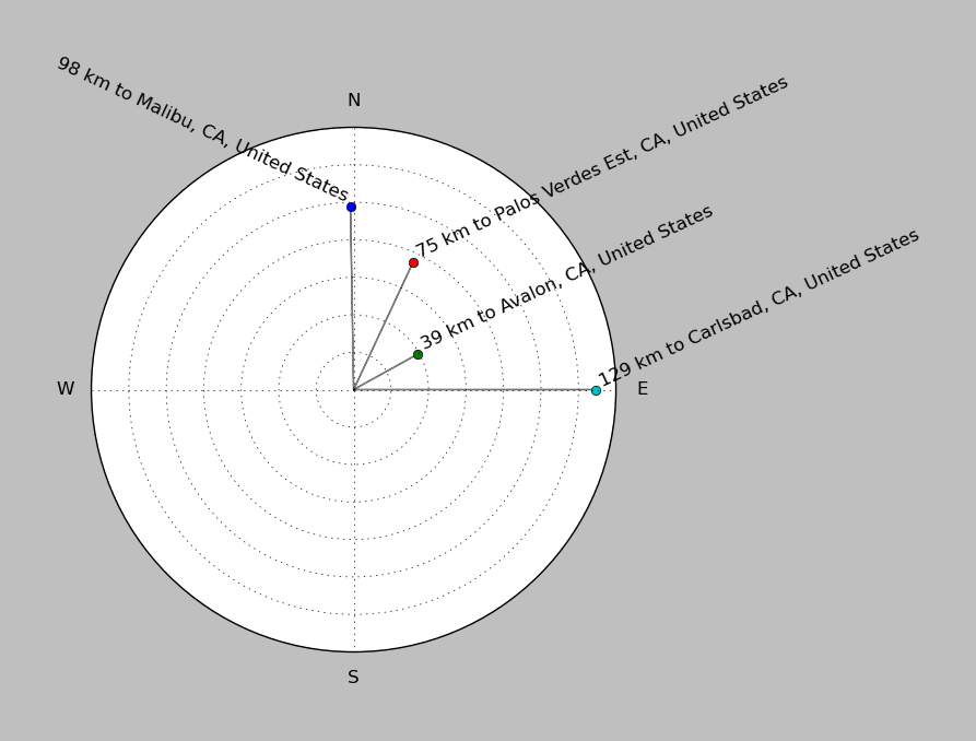
| ||||||||||||||||
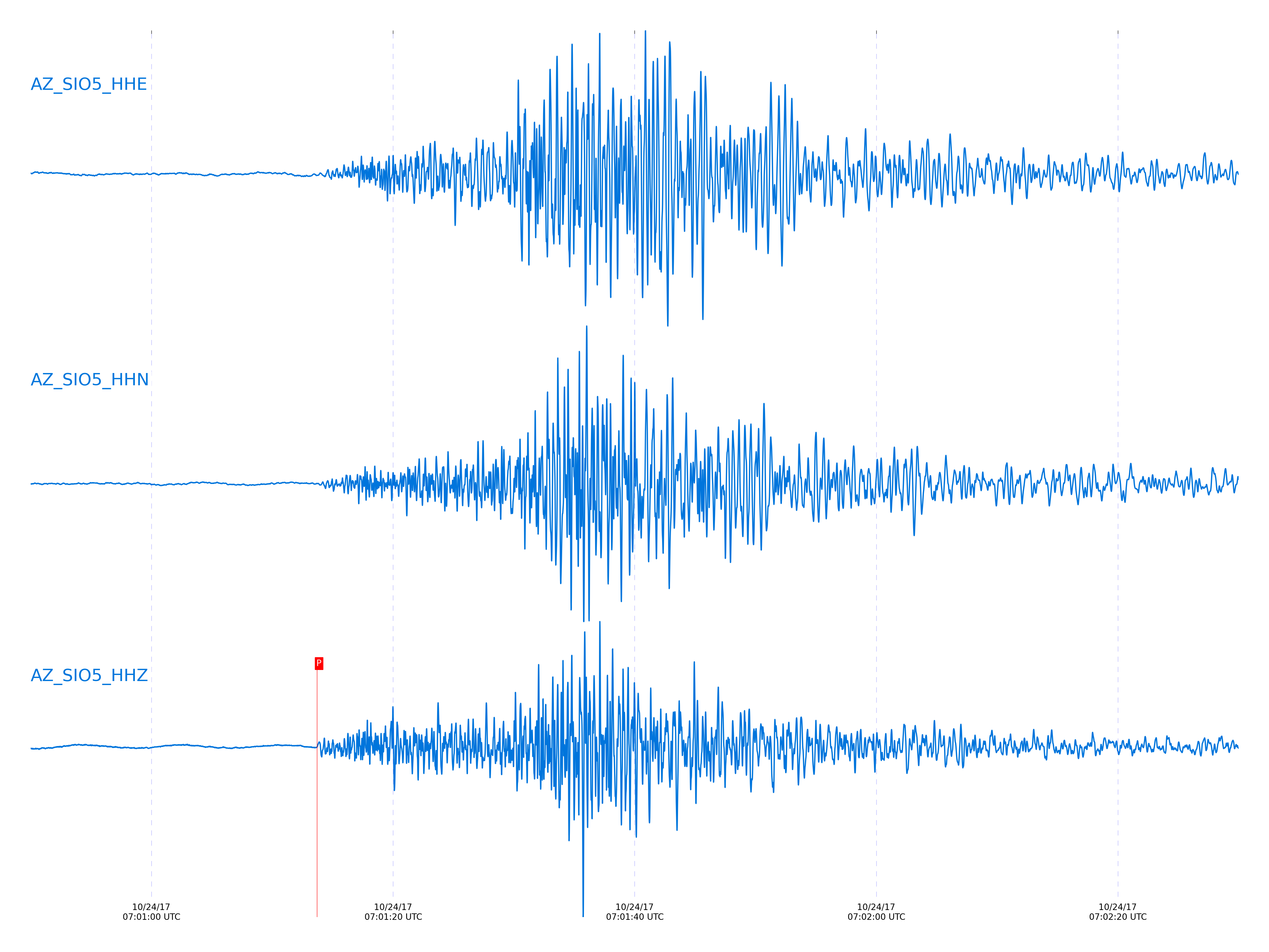
Event and active stations
|
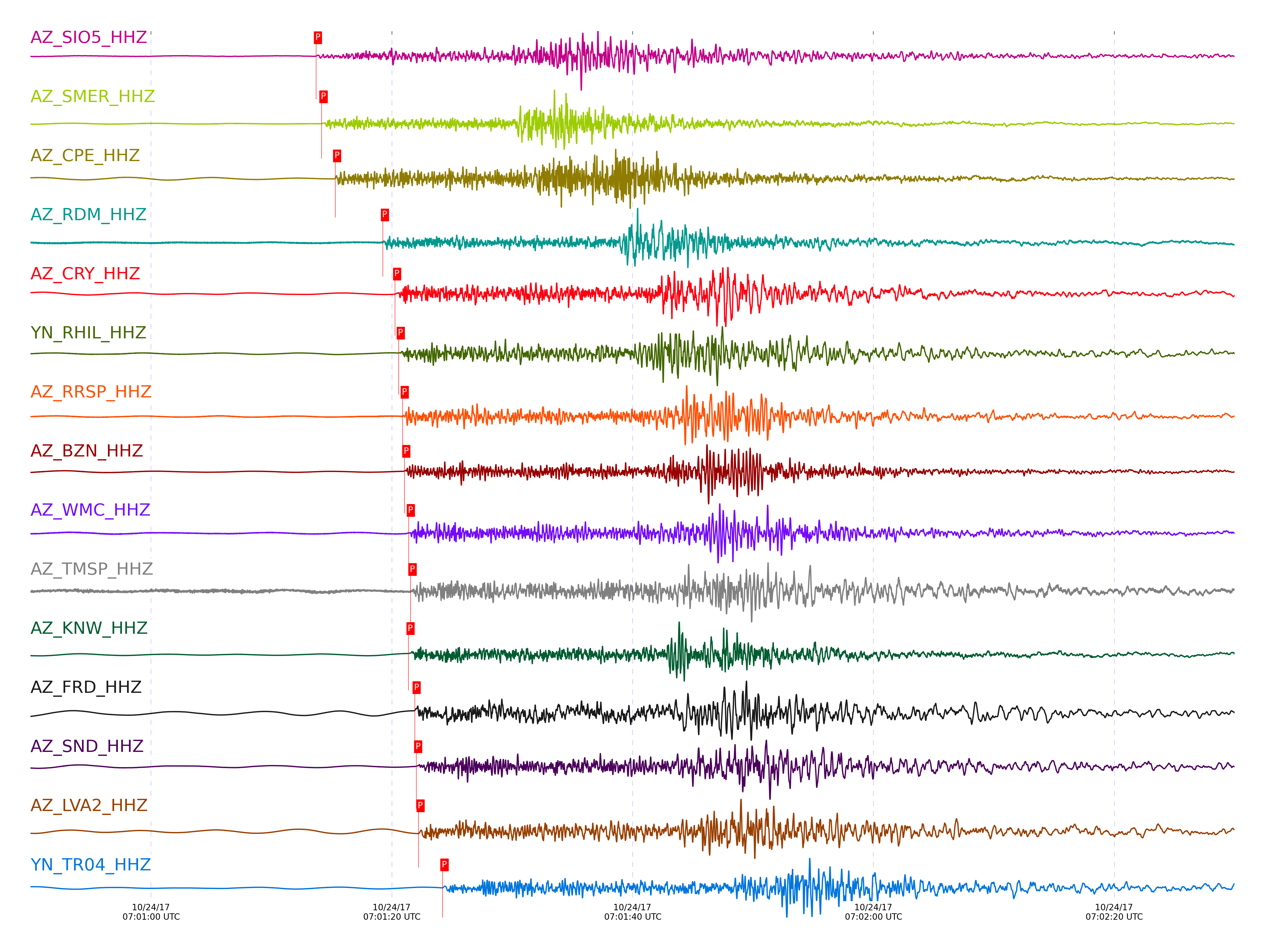
|||||||||||||||||
Closest station with identified signal. Not filtered.
Subset of several stations close to the event. Not filtered.
| STA_CHAN | S-E Delta | S-E Azimuth | Phase | Time | Signal/Noise | Time Residual | V. Model | Auth | arid |
|---|---|---|---|---|---|---|---|---|---|
| SIO5_HHZ | 1.272° | 284.9° | Pg | 2017-10-24 07:01:13.7024 UTC | 44.12 | -2.374 | iasp91 | dbp:jtytell:172 | 1561278 |
| SMER_HHZ | 1.327° | 257.42° | Pn | 2017-10-24 07:01:14.1635 UTC | 75.204 | -2.713 | iasp91 | dbp:jtytell:172 | 1561279 |
| SMER_HHN | 1.327° | 257.42° | Sb | 2017-10-24 07:01:30.2629 UTC | -1 | -5.32 | iasp91 | dbp:jtytell:172 | 1561762 |
| CPE_HHZ | 1.379° | 281.74° | Pn | 2017-10-24 07:01:15.2984 UTC | 80.03 | -2.294 | iasp91 | dbp:jtytell:172 | 1561280 |
| CPE_HHN | 1.379° | 281.74° | Sn | 2017-10-24 07:01:31.9664 UTC | -1 | -5.135 | iasp91 | dbp:jtytell:172 | 1561764 |
| RDM_HHZ | 1.631° | 253.74° | Pn | 2017-10-24 07:01:19.2619 UTC | 9.5125 | -1.793 | iasp91 | dbp:jtytell:172 | 1561281 |
| RDM_HHN | 1.631° | 253.74° | Sn | 2017-10-24 07:01:38.8104 UTC | -1 | -4.52 | iasp91 | dbp:jtytell:172 | 1561774 |
| CRY_HHZ | 1.703° | 256.75° | Pn | 2017-10-24 07:01:20.2681 UTC | 266.1 | -1.785 | iasp91 | dbp:jtytell:172 | 1561282 |
| CRY_HHN | 1.703° | 256.75° | Sn | 2017-10-24 07:01:41.2136 UTC | -1 | -3.912 | iasp91 | dbp:jtytell:172 | 1561777 |
| RHIL_HHZ | 1.704° | 252.98° | Pn | 2017-10-24 07:01:20.5698 UTC | -1 | -1.494 | iasp91 | dbp:jtytell:172 | 1561724 |
| RHIL_HHE | 1.704° | 252.98° | Sn | 2017-10-24 07:01:41.4444 UTC | -1 | -3.701 | iasp91 | dbp:jtytell:172 | 1561778 |
| RRSP_HHZ | 1.723° | 253.95° | Pn | 2017-10-24 07:01:20.9076 UTC | -1 | -1.422 | iasp91 | dbp:jtytell:172 | 1561727 |
| BZN_HHZ | 1.745° | 259.59° | Pn | 2017-10-24 07:01:21.0344 UTC | 111.23 | -1.599 | iasp91 | dbp:jtytell:172 | 1561283 |
| BZN_HHN | 1.745° | 259.59° | Sn | 2017-10-24 07:01:42.6072 UTC | -1 | -3.563 | iasp91 | dbp:jtytell:172 | 1561781 |
| WMC_HHZ | 1.756° | 256.91° | Pn | 2017-10-24 07:01:21.4039 UTC | 39.802 | -1.373 | iasp91 | dbp:jtytell:172 | 1561287 |
| WMC_HHN | 1.756° | 256.91° | Sn | 2017-10-24 07:01:42.9691 UTC | -1 | -3.459 | iasp91 | dbp:jtytell:172 | 1561783 |
| TMSP_HHZ | 1.762° | 255.43° | Pn | 2017-10-24 07:01:21.5494 UTC | -1 | -1.309 | iasp91 | dbp:jtytell:172 | 1561732 |
| KNW_HHZ | 1.763° | 252.21° | Pn | 2017-10-24 07:01:21.3867 UTC | 302.82 | -1.494 | iasp91 | dbp:jtytell:172 | 1561285 |
| KNW_HHN | 1.763° | 252.21° | Sn | 2017-10-24 07:01:42.7826 UTC | -1 | -3.832 | iasp91 | dbp:jtytell:172 | 1561786 |
| FRD_HHZ | 1.799° | 259.84° | Pn | 2017-10-24 07:01:21.8946 UTC | 279.25 | -1.478 | iasp91 | dbp:jtytell:172 | 1561289 |
| SND_HHZ | 1.801° | 257.99° | Pn | 2017-10-24 07:01:22.0223 UTC | 239.38 | -1.381 | iasp91 | dbp:jtytell:172 | 1561291 |
| LVA2_HHZ | 1.813° | 264.5° | Pn | 2017-10-24 07:01:22.2131 UTC | 411.63 | -1.355 | iasp91 | dbp:jtytell:172 | 1561293 |
| LVA2_HHE | 1.813° | 264.5° | Sn | 2017-10-24 07:01:44.3776 UTC | -1 | -3.472 | iasp91 | dbp:jtytell:172 | 1561791 |
| TR04_HHZ | 1.931° | 263.5° | Pn | 2017-10-24 07:01:24.2053 UTC | -1 | -0.978 | iasp91 | dbp:jtytell:172 | 1561739 |
| TR03_HHZ | 1.934° | 263.2° | Pn | 2017-10-24 07:01:24.1886 UTC | -1 | -1.043 | iasp91 | dbp:jtytell:172 | 1561741 |
| PFO_HHZ | 1.939° | 257.13° | Pn | 2017-10-24 07:01:24.03 UTC | 68.65 | -1.268 | iasp91 | dbp:jtytell:172 | 1561301 |
| TR02_HHZ | 1.941° | 262.96° | Pn | 2017-10-24 07:01:24.3176 UTC | -1 | -1.002 | iasp91 | dbp:jtytell:172 | 1561745 |
| MONP2_HHZ | 1.943° | 278.53° | Pn | 2017-10-24 07:01:23.7515 UTC | 21.4 | -1.599 | iasp91 | dbp:jtytell:172 | 1561297 |
| MONP2_HHN | 1.943° | 278.53° | Sn | 2017-10-24 07:01:47.5442 UTC | -1 | -3.513 | iasp91 | dbp:jtytell:172 | 1561803 |
| TRO_HHN | 1.949° | 259.86° | Sn | 2017-10-24 07:01:48.9345 UTC | -1 | -2.273 | iasp91 | dbp:jtytell:172 | 1561807 |
Click the link below to observe an interactive map of earthquakes recorded by the station deployment:
Broadband Seismic Data Collection Center (ANZA),
Institute of Geophysics & Planetary Physics
Scripps Institution of Oceanography,
University of California San Diego
Copyright © 1989 - 2014. All Rights Reserved.