
last update to page: November 10 2017 01:43:35 (UTC).
SummaryThe red marker denotes the earthquake epicenter. On Fri Nov 10th 2017 00:23:29 (UTC) the seismic network recorded an earthquake (preliminary 3.64 ml) located in Southern California. Seismic region California - Nevada Region. The epicentral distance (i.e. distance separating the location to the epicenter) to the closest station ALCY in the network is 5.4 km. If you felt the quake, the USGS would like to know. Please add your comments to the USGS page "Did you feel it?". |
Details
Proximity to Population Centers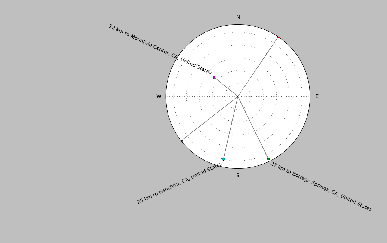
| ||||||||||||||||
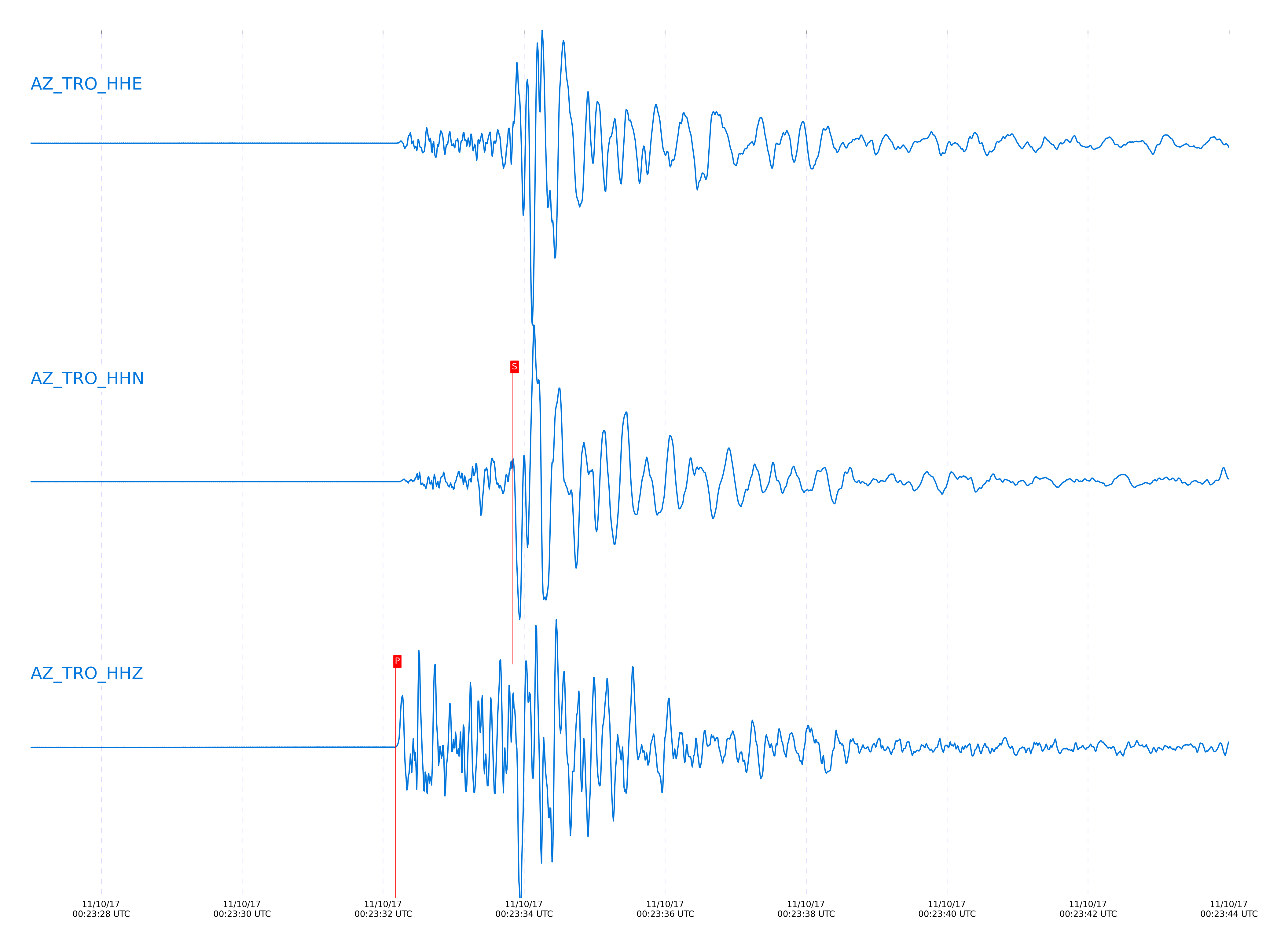
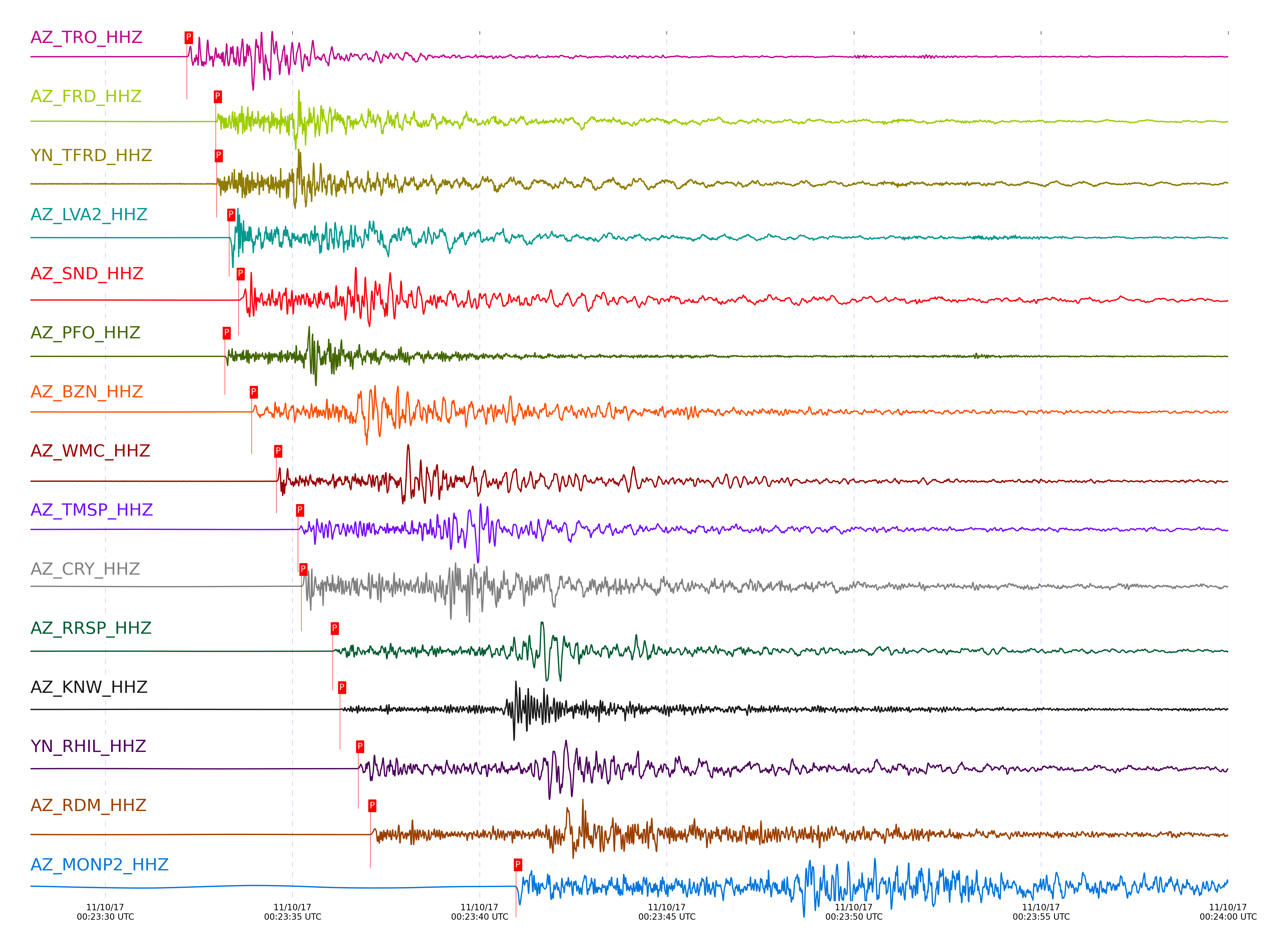
Event and active stations
|
|||||||||||||||||
Closest station with identified signal. Not filtered.
Subset of several stations close to the event. Not filtered.
| STA_CHAN | S-E Delta | S-E Azimuth | Phase | Time | Signal/Noise | Time Residual | V. Model | Auth | arid |
|---|---|---|---|---|---|---|---|---|---|
| TRO_HHZ | 0.077° | 214.5° | P | 2017-11-10 00:23:32.1741 UTC | 785.85 | -0.484 | iasp91 | dbp:jtytell:173 | 1581845 |
| TRO_HHN | 0.077° | 214.5° | S | 2017-11-10 00:23:33.8322 UTC | -1 | -1.09 | iasp91 | dbp:jtytell:173 | 1582339 |
| FRD_HHZ | 0.109° | 108.6° | P | 2017-11-10 00:23:32.9475 UTC | 4363.8 | 0.282 | iasp91 | dbp:jtytell:173 | 1581846 |
| FRD_HHN | 0.109° | 108.6° | S | 2017-11-10 00:23:34.9813 UTC | -1 | 0.048 | iasp91 | dbp:jtytell:173 | 1582344 |
| TFRD_HHZ | 0.109° | 108.65° | P | 2017-11-10 00:23:32.9753 UTC | -1 | 0.333 | iasp91 | dbp:jtytell:173 | 1582286 |
| TFRD_HHE | 0.109° | 108.65° | S | 2017-11-10 00:23:34.9818 UTC | -1 | 0.093 | iasp91 | dbp:jtytell:173 | 1582345 |
| LVA2_HHZ | 0.129° | 32.74° | P | 2017-11-10 00:23:33.3054 UTC | 10684 | 0.313 | iasp91 | dbp:jtytell:173 | 1581849 |
| LVA2_HHN | 0.129° | 32.74° | S | 2017-11-10 00:23:35.7076 UTC | -1 | 0.223 | iasp91 | dbp:jtytell:173 | 1582348 |
| JORD_HHE | 0.14° | 95.05° | S | 2017-11-10 00:23:35.967 UTC | -1 | 0.256 | iasp91 | dbp:jtytell:173 | 1582352 |
| SND_HHZ | 0.146° | 129.3° | P | 2017-11-10 00:23:33.5584 UTC | 3605.1 | 0.324 | iasp91 | dbp:jtytell:173 | 1581850 |
| SND_HHE | 0.146° | 129.3° | S | 2017-11-10 00:23:36.3229 UTC | -1 | 0.437 | iasp91 | dbp:jtytell:173 | 1582357 |
| PFO_HHZ | 0.153° | 185.86° | P | 2017-11-10 00:23:33.1884 UTC | 5343.6 | -0.145 | iasp91 | dbp:jtytell:173 | 1581847 |
| PFO_HHE | 0.153° | 185.86° | S | 2017-11-10 00:23:35.3879 UTC | -1 | -0.664 | iasp91 | dbp:jtytell:173 | 1582354 |
| BZN_HHZ | 0.161° | 101.33° | P | 2017-11-10 00:23:33.9109 UTC | 1162.7 | 0.447 | iasp91 | dbp:jtytell:173 | 1581852 |
| BZN_HHN | 0.161° | 101.33° | S | 2017-11-10 00:23:36.549 UTC | -1 | 0.274 | iasp91 | dbp:jtytell:173 | 1582360 |
| WMC_HHZ | 0.2° | 124.72° | P | 2017-11-10 00:23:34.564 UTC | 84.457 | 0.482 | iasp91 | dbp:jtytell:173 | 1581853 |
| WMC_HHN | 0.2° | 124.72° | S | 2017-11-10 00:23:37.7032 UTC | -1 | 0.377 | iasp91 | dbp:jtytell:173 | 1582365 |
| TMSP_HHZ | 0.233° | 133.26° | P | 2017-11-10 00:23:35.1447 UTC | -1 | 0.404 | iasp91 | dbp:jtytell:173 | 1582298 |
| TMSP_HHE | 0.233° | 133.26° | S | 2017-11-10 00:23:39.0421 UTC | -1 | 0.569 | iasp91 | dbp:jtytell:173 | 1582370 |
| CRY_HHZ | 0.241° | 115.97° | P | 2017-11-10 00:23:35.2341 UTC | 1442.8 | 0.467 | iasp91 | dbp:jtytell:173 | 1581854 |
| CRY_HHN | 0.241° | 115.97° | S | 2017-11-10 00:23:38.7497 UTC | -1 | 0.249 | iasp91 | dbp:jtytell:173 | 1582373 |
| RRSP_HHZ | 0.29° | 131.29° | P | 2017-11-10 00:23:36.0734 UTC | -1 | 0.371 | iasp91 | dbp:jtytell:173 | 1582306 |
| RRSP_HHN | 0.29° | 131.29° | S | 2017-11-10 00:23:40.4871 UTC | -1 | 0.365 | iasp91 | dbp:jtytell:173 | 1582378 |
| KNW_HHZ | 0.321° | 142.49° | P | 2017-11-10 00:23:36.2684 UTC | 650.35 | 0.035 | iasp91 | dbp:jtytell:173 | 1581857 |
| KNW_HHE | 0.321° | 142.49° | S | 2017-11-10 00:23:40.6001 UTC | -1 | -0.442 | iasp91 | dbp:jtytell:173 | 1582381 |
| RHIL_HHZ | 0.325° | 131.06° | P | 2017-11-10 00:23:36.7511 UTC | -1 | 0.438 | iasp91 | dbp:jtytell:173 | 1582304 |
| RHIL_HHN | 0.325° | 131.06° | S | 2017-11-10 00:23:41.5702 UTC | -1 | 0.388 | iasp91 | dbp:jtytell:173 | 1582382 |
| RDM_HHZ | 0.352° | 118.81° | P | 2017-11-10 00:23:37.0784 UTC | 128.64 | 0.281 | iasp91 | dbp:jtytell:173 | 1581858 |
| RDM_HHN | 0.352° | 118.81° | S | 2017-11-10 00:23:41.995 UTC | -1 | -0.027 | iasp91 | dbp:jtytell:173 | 1582384 |
| MONP2_HHZ | 0.57° | 355.31° | P | 2017-11-10 00:23:40.9684 UTC | 137.32 | 0.046 | iasp91 | dbp:jtytell:173 | 1581859 |
| SMER_HHZ | 0.578° | 89.6° | P | 2017-11-10 00:23:41.2384 UTC | 932.9 | 0.321 | iasp91 | dbp:jtytell:173 | 1581873 |
| SMER_HHN | 0.578° | 89.6° | S | 2017-11-10 00:23:48.9353 UTC | -1 | -0.194 | iasp91 | dbp:jtytell:173 | 1582396 |
| CPE_HHZ | 0.776° | 42.42° | P | 2017-11-10 00:23:44.4684 UTC | 181.27 | -0.17 | iasp91 | dbp:jtytell:173 | 1581875 |
| CPE_HHN | 0.776° | 42.42° | S | 2017-11-10 00:23:54.5664 UTC | -1 | -0.976 | iasp91 | dbp:jtytell:173 | 1582407 |
| SIO5_HHN | 0.895° | 46.01° | S | 2017-11-10 00:23:58.7735 UTC | -1 | -0.66 | iasp91 | dbp:jtytell:173 | 1582414 |
Click the link below to observe an interactive map of earthquakes recorded by the station deployment:
Broadband Seismic Data Collection Center (ANZA),
Institute of Geophysics & Planetary Physics
Scripps Institution of Oceanography,
University of California San Diego
Copyright © 1989 - 2014. All Rights Reserved.