
last update to page: January 25 2018 20:01:13 (UTC).
SummaryThe red marker denotes the earthquake epicenter. On Thu Jan 25th 2018 10:09:56 (UTC) the seismic network recorded an earthquake (preliminary 3.94 mw) located in Southern California. Seismic region California - Nevada Region. The epicentral distance (i.e. distance separating the location to the epicenter) to the closest station SMER in the network is 43.3 km. If you felt the quake, the USGS would like to know. Please add your comments to the USGS page "Did you feel it?". |
Details
Proximity to Population Centers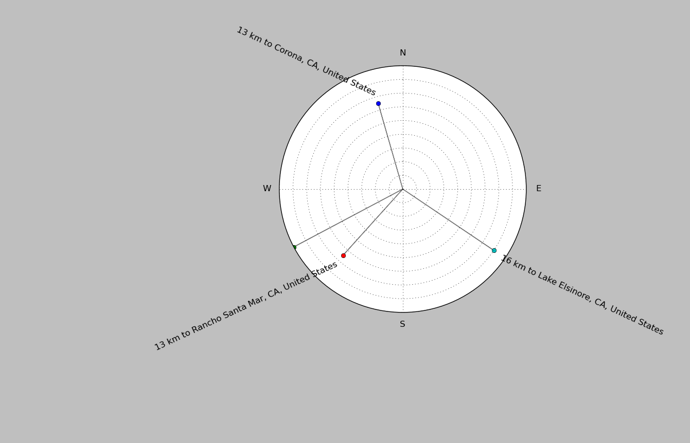
| ||||||||||||||||
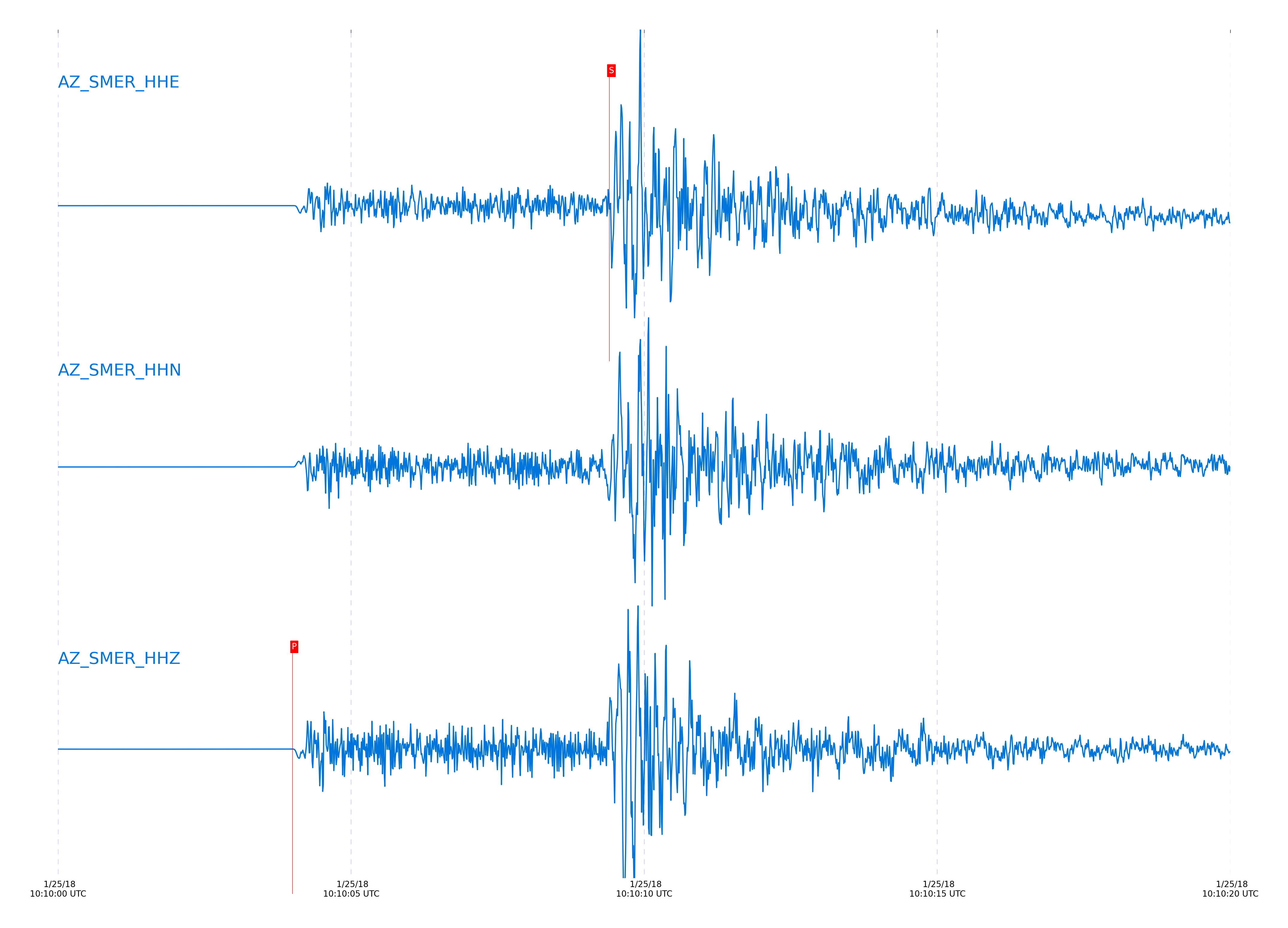
Event and active stations
|
|||||||||||||||||
Closest station with identified signal. Not filtered.
Subset of several stations close to the event. Not filtered.
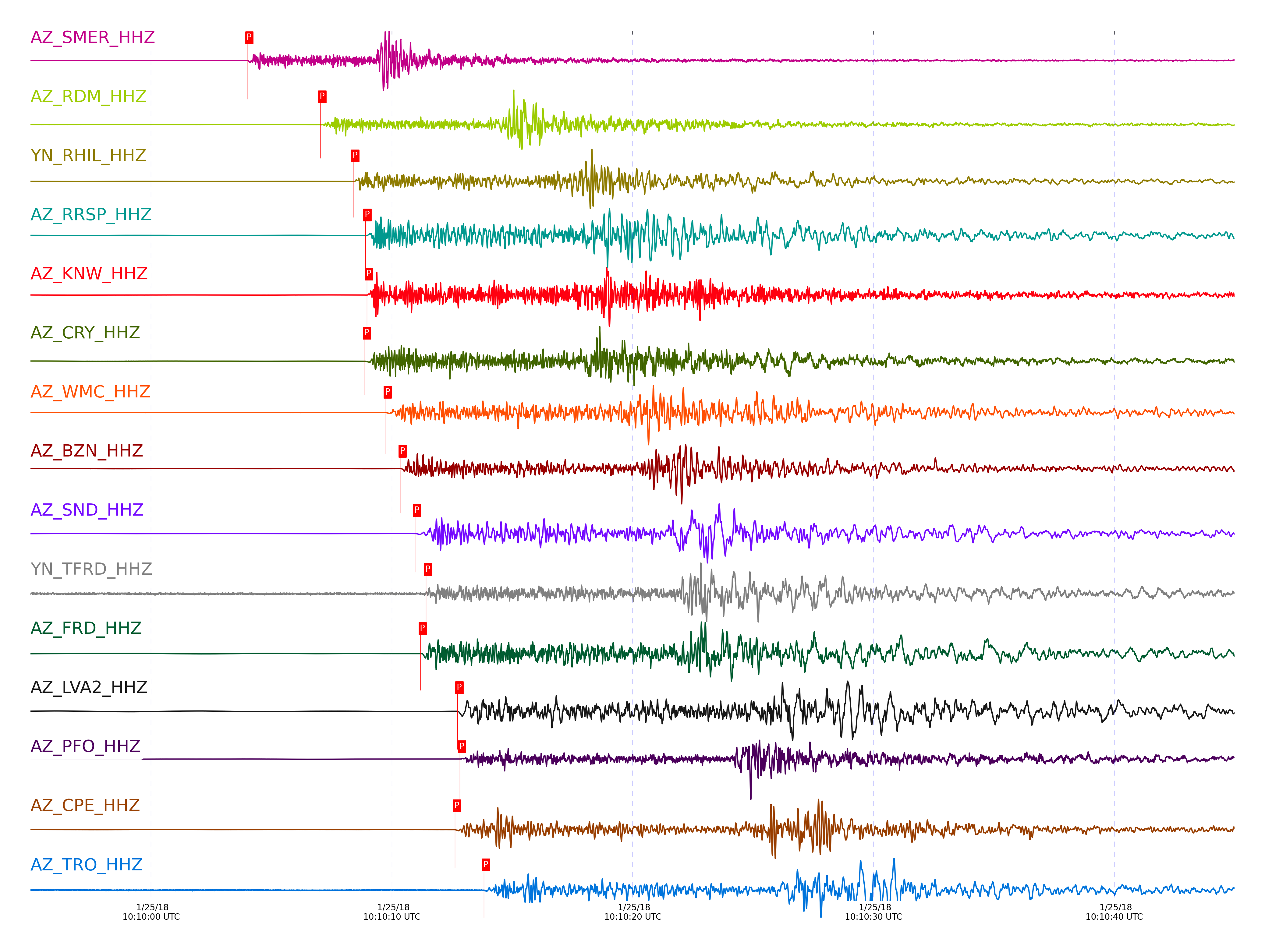
| STA_CHAN | S-E Delta | S-E Azimuth | Phase | Time | Signal/Noise | Time Residual | V. Model | Auth | arid |
|---|---|---|---|---|---|---|---|---|---|
| SMER_HHZ | 0.389° | 316.8° | Pg | 2018-01-25 10:10:03.9984 UTC | 2829.7 | -0.509 | iasp91 | dbp:jtytell:180 | 1666914 |
| SMER_HHE | 0.389° | 316.8° | Sg | 2018-01-25 10:10:09.4051 UTC | -1 | -0.702 | iasp91 | dbp:jtytell:180 | 1667395 |
| RDM_HHZ | 0.547° | 281.89° | Pg | 2018-01-25 10:10:07.0321 UTC | 406.02 | -0.435 | iasp91 | dbp:jtytell:180 | 1666916 |
| RDM_HHN | 0.547° | 281.89° | Sg | 2018-01-25 10:10:14.4962 UTC | -1 | -0.722 | iasp91 | dbp:jtytell:180 | 1667399 |
| RHIL_HHZ | 0.603° | 276.66° | Pg | 2018-01-25 10:10:08.3966 UTC | -1 | -0.128 | iasp91 | dbp:jtytell:180 | 1667347 |
| RHIL_HHE | 0.603° | 276.66° | Sg | 2018-01-25 10:10:17.0197 UTC | -1 | -0.022 | iasp91 | dbp:jtytell:180 | 1667402 |
| RRSP_HHZ | 0.632° | 278.35° | Pg | 2018-01-25 10:10:08.9043 UTC | -1 | -0.172 | iasp91 | dbp:jtytell:180 | 1667350 |
| KNW_HHZ | 0.649° | 272.59° | Pg | 2018-01-25 10:10:08.9679 UTC | 866.4 | -0.427 | iasp91 | dbp:jtytell:180 | 1666918 |
| KNW_HHN | 0.649° | 272.59° | Sg | 2018-01-25 10:10:17.8008 UTC | -1 | -0.741 | iasp91 | dbp:jtytell:180 | 1667407 |
| CRY_HHZ | 0.652° | 285.84° | Pg | 2018-01-25 10:10:08.8834 UTC | 455.67 | -0.567 | iasp91 | dbp:jtytell:180 | 1666948 |
| CRY_HHN | 0.652° | 285.84° | Sg | 2018-01-25 10:10:17.9299 UTC | -1 | -0.709 | iasp91 | dbp:jtytell:180 | 1667409 |
| WMC_HHZ | 0.7° | 284.06° | Pg | 2018-01-25 10:10:09.7484 UTC | 451.04 | -0.617 | iasp91 | dbp:jtytell:180 | 1666924 |
| WMC_HHN | 0.7° | 284.06° | Sg | 2018-01-25 10:10:19.2092 UTC | -1 | -1.007 | iasp91 | dbp:jtytell:180 | 1667414 |
| BZN_HHZ | 0.73° | 290.2° | Pg | 2018-01-25 10:10:10.3679 UTC | 375.79 | -0.573 | iasp91 | dbp:jtytell:180 | 1666951 |
| BZN_HHN | 0.73° | 290.2° | Sg | 2018-01-25 10:10:20.19 UTC | -1 | -1.02 | iasp91 | dbp:jtytell:180 | 1667415 |
| SND_HHZ | 0.755° | 284.74° | Pg | 2018-01-25 10:10:10.9606 UTC | 3197.4 | -0.453 | iasp91 | dbp:jtytell:180 | 1666926 |
| SND_HHN | 0.755° | 284.74° | Sg | 2018-01-25 10:10:21.716 UTC | -1 | -0.309 | iasp91 | dbp:jtytell:180 | 1667418 |
| TFRD_HHZ | 0.78° | 288.64° | Pg | 2018-01-25 10:10:11.4161 UTC | -1 | -0.471 | iasp91 | dbp:jtytell:180 | 1667361 |
| TFRD_HHN | 0.78° | 288.64° | Sg | 2018-01-25 10:10:21.8655 UTC | -1 | -0.976 | iasp91 | dbp:jtytell:180 | 1667423 |
| FRD_HHZ | 0.78° | 288.65° | Pg | 2018-01-25 10:10:11.2001 UTC | 334.33 | -0.688 | iasp91 | dbp:jtytell:180 | 1666952 |
| FRD_HHN | 0.78° | 288.65° | Sg | 2018-01-25 10:10:21.7527 UTC | -1 | -1.09 | iasp91 | dbp:jtytell:180 | 1667422 |
| LVA2_HHZ | 0.867° | 296.94° | Pg | 2018-01-25 10:10:12.7231 UTC | 700.62 | -0.817 | iasp91 | dbp:jtytell:180 | 1666930 |
| LVA2_HHE | 0.867° | 296.94° | Sg | 2018-01-25 10:10:24.6696 UTC | -1 | -1.024 | iasp91 | dbp:jtytell:180 | 1667430 |
| PFO_HHZ | 0.868° | 278.85° | Pg | 2018-01-25 10:10:12.8283 UTC | 776.29 | -0.733 | iasp91 | dbp:jtytell:180 | 1666931 |
| PFO_HHE | 0.868° | 278.85° | Sg | 2018-01-25 10:10:24.2398 UTC | -1 | -1.491 | iasp91 | dbp:jtytell:180 | 1667432 |
| CPE_HHZ | 0.911° | 339.37° | Pg | 2018-01-25 10:10:12.6184 UTC | 1025.7 | -1.757 | iasp91 | dbp:jtytell:180 | 1666929 |
| CPE_HHE | 0.911° | 339.37° | Sg | 2018-01-25 10:10:24.783 UTC | -1 | -2.352 | iasp91 | dbp:jtytell:180 | 1667439 |
| TRO_HHZ | 0.913° | 284.08° | Pg | 2018-01-25 10:10:13.8305 UTC | 36.154 | -0.589 | iasp91 | dbp:jtytell:180 | 1666934 |
| TRO_HHN | 0.913° | 284.08° | Sg | 2018-01-25 10:10:26.2562 UTC | -1 | -0.954 | iasp91 | dbp:jtytell:180 | 1667440 |
| SIO5_HHZ | 0.923° | 347.43° | Pg | 2018-01-25 10:10:13.3786 UTC | 250.62 | -1.216 | iasp91 | dbp:jtytell:180 | 1666933 |
| MONP2_HHZ | 1.232° | 313.84° | Pn | 2018-01-25 10:10:18.3058 UTC | 86.771 | -1.634 | iasp91 | dbp:jtytell:180 | 1666957 |
| MONP2_HHE | 1.232° | 313.84° | Sb | 2018-01-25 10:10:34.681 UTC | -1 | -2.388 | iasp91 | dbp:jtytell:180 | 1667450 |
Click the link below to observe an interactive map of earthquakes recorded by the station deployment:
Broadband Seismic Data Collection Center (ANZA),
Institute of Geophysics & Planetary Physics
Scripps Institution of Oceanography,
University of California San Diego
Copyright © 1989 - 2014. All Rights Reserved.