
last update to page: February 17 2018 00:15:29 (UTC).
SummaryThe red marker denotes the earthquake epicenter. On Fri Feb 16th 2018 23:39:42 (UTC) the seismic network recorded an earthquake (preliminary 7.2 mww) located in Oaxaca, Mexico. Seismic region Mexico - Guatemala Area. The epicentral distance (i.e. distance separating the location to the epicenter) to the closest station USGCB in the network is 2,598.0 km. If you felt the quake, the USGS would like to know. Please add your comments to the USGS page "Did you feel it?". |
Details
Proximity to Population Centers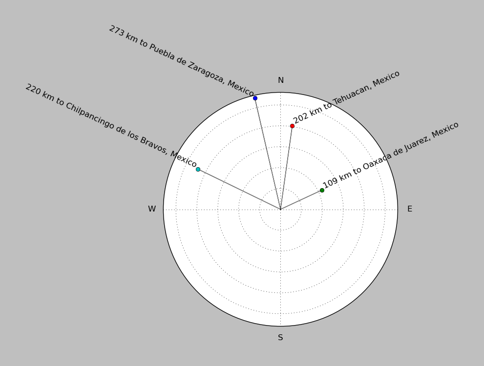
| ||||||||||||||||
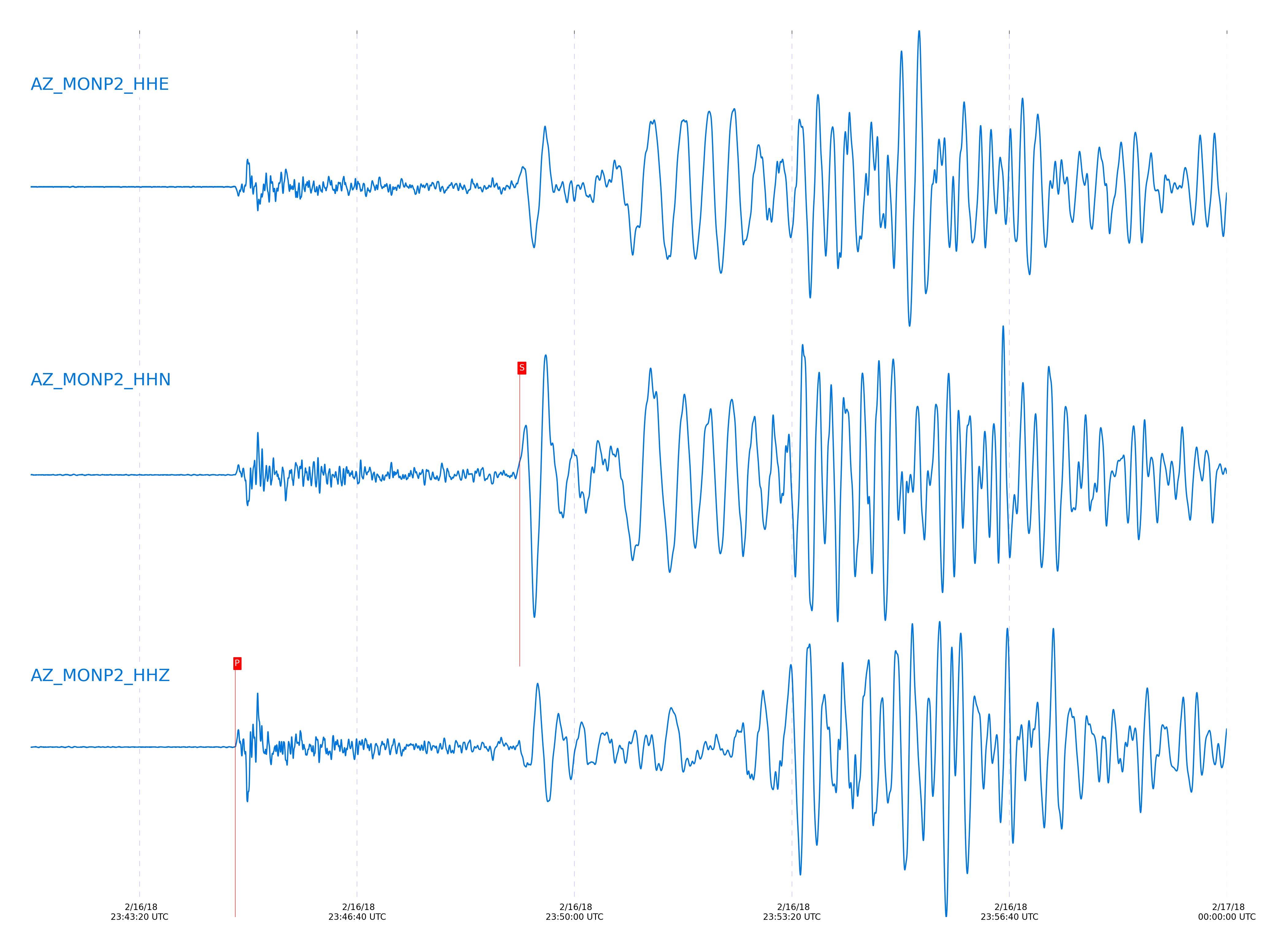
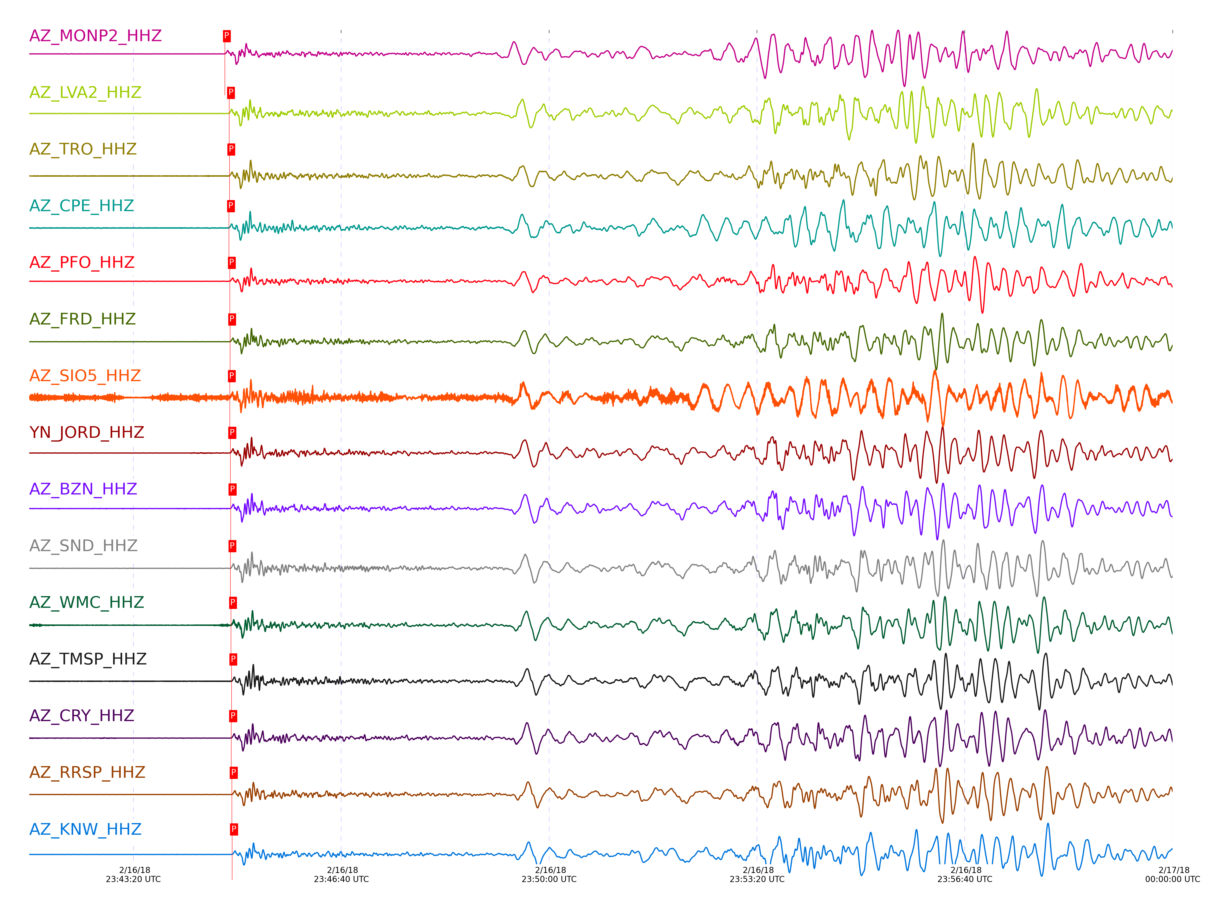
Event and active stations
|
|||||||||||||||||
Closest station with identified signal. Not filtered.
Subset of several stations close to the event. Not filtered.
| STA_CHAN | S-E Delta | S-E Azimuth | Phase | Time | Signal/Noise | Time Residual | V. Model | Auth | arid |
|---|---|---|---|---|---|---|---|---|---|
| MONP2_HHZ | 23.467° | 129.27° | P | 2018-02-16 23:44:48.0849 UTC | 342.99 | -1.932 | iasp91 | dbp:jtytell:180 | 1685862 |
| MONP2_HHN | 23.467° | 129.27° | S | 2018-02-16 23:49:09.6349 UTC | -1 | 4.389 | iasp91 | dbp:jtytell:180 | 1685968 |
| LVA2_HHZ | 23.85° | 129.84° | P | 2018-02-16 23:44:52.1658 UTC | 221.42 | -1.349 | iasp91 | dbp:jtytell:180 | 1685863 |
| LVA2_HHE | 23.85° | 129.84° | S | 2018-02-16 23:49:14.5384 UTC | -1 | 2.034 | iasp91 | dbp:jtytell:180 | 1685981 |
| TRO_HHZ | 23.874° | 130.38° | P | 2018-02-16 23:44:52.5117 UTC | 422.67 | -1.223 | iasp91 | dbp:jtytell:180 | 1685864 |
| TRO_HHE | 23.874° | 130.38° | S | 2018-02-16 23:49:14.445 UTC | -1 | 1.487 | iasp91 | dbp:jtytell:180 | 1685984 |
| CPE_HHZ | 23.913° | 128.08° | P | 2018-02-16 23:44:52.059 UTC | 166.38 | -2.033 | iasp91 | dbp:jtytell:180 | 1685909 |
| CPE_HHE | 23.913° | 128.08° | S | 2018-02-16 23:49:13.2387 UTC | -1 | -0.458 | iasp91 | dbp:jtytell:180 | 1685985 |
| PFO_HHZ | 23.953° | 130.47° | P | 2018-02-16 23:44:52.938 UTC | 271.52 | -1.515 | iasp91 | dbp:jtytell:180 | 1685865 |
| PFO_HHE | 23.953° | 130.47° | S | 2018-02-16 23:49:16.1016 UTC | -1 | 1.658 | iasp91 | dbp:jtytell:180 | 1685991 |
| FRD_HHZ | 23.968° | 130.01° | P | 2018-02-16 23:44:53.1545 UTC | 538.72 | -1.438 | iasp91 | dbp:jtytell:180 | 1685866 |
| FRD_HHE | 23.968° | 130.01° | S | 2018-02-16 23:49:16.8664 UTC | -1 | 2.135 | iasp91 | dbp:jtytell:180 | 1685993 |
| SIO5_HHZ | 23.979° | 127.75° | P | 2018-02-16 23:44:52.9464 UTC | 82.142 | -1.75 | iasp91 | dbp:jtytell:180 | 1685903 |
| JORD_HHZ | 23.981° | 129.9° | P | 2018-02-16 23:44:53.4161 UTC | 468.78 | -1.294 | iasp91 | dbp:jtytell:180 | 1685868 |
| JORD_HHE | 23.981° | 129.9° | S | 2018-02-16 23:49:16.6716 UTC | -1 | 1.696 | iasp91 | dbp:jtytell:180 | 1685994 |
| BZN_HHZ | 24.007° | 129.89° | P | 2018-02-16 23:44:53.658 UTC | 432.47 | -1.294 | iasp91 | dbp:jtytell:180 | 1685867 |
| BZN_HHE | 24.007° | 129.89° | S | 2018-02-16 23:49:16.2878 UTC | -1 | 0.814 | iasp91 | dbp:jtytell:180 | 1685995 |
| SND_HHZ | 24.012° | 130.09° | P | 2018-02-16 23:44:53.5082 UTC | -1 | -1.483 | iasp91 | dbp:jtytell:180 | 1685935 |
| SND_HHE | 24.012° | 130.09° | S | 2018-02-16 23:49:17.8903 UTC | -1 | 2.336 | iasp91 | dbp:jtytell:180 | 1685996 |
| WMC_HHZ | 24.065° | 130.02° | P | 2018-02-16 23:44:54.0925 UTC | 322.12 | -1.386 | iasp91 | dbp:jtytell:180 | 1685870 |
| WMC_HHE | 24.065° | 130.02° | S | 2018-02-16 23:49:18.3778 UTC | -1 | 1.817 | iasp91 | dbp:jtytell:180 | 1686000 |
| TMSP_HHZ | 24.098° | 130.09° | P | 2018-02-16 23:44:54.4004 UTC | -1 | -1.382 | iasp91 | dbp:jtytell:180 | 1685939 |
| TMSP_HHE | 24.098° | 130.09° | S | 2018-02-16 23:49:18.3691 UTC | -1 | 1.182 | iasp91 | dbp:jtytell:180 | 1686001 |
| CRY_HHZ | 24.1° | 129.9° | P | 2018-02-16 23:44:54.2548 UTC | 301.78 | -1.54 | iasp91 | dbp:jtytell:180 | 1685869 |
| CRY_HHE | 24.1° | 129.9° | S | 2018-02-16 23:49:17.4439 UTC | -1 | 0.23 | iasp91 | dbp:jtytell:180 | 1686002 |
| RRSP_HHZ | 24.156° | 130.04° | P | 2018-02-16 23:44:54.8298 UTC | -1 | -1.483 | iasp91 | dbp:jtytell:180 | 1685943 |
| RRSP_HHE | 24.156° | 130.04° | S | 2018-02-16 23:49:19.2119 UTC | -1 | 0.932 | iasp91 | dbp:jtytell:180 | 1686005 |
| KNW_HHZ | 24.179° | 130.2° | P | 2018-02-16 23:44:55.0465 UTC | 263.51 | -1.474 | iasp91 | dbp:jtytell:180 | 1685874 |
| KNW_HHN | 24.179° | 130.2° | S | 2018-02-16 23:49:22.8601 UTC | -1 | 4.151 | iasp91 | dbp:jtytell:180 | 1686007 |
| RHIL_HHZ | 24.191° | 130.02° | P | 2018-02-16 23:44:55.1922 UTC | -1 | -1.433 | iasp91 | dbp:jtytell:180 | 1685945 |
| RHIL_HHN | 24.191° | 130.02° | S | 2018-02-16 23:49:25.4662 UTC | -1 | 6.542 | iasp91 | dbp:jtytell:180 | 1686008 |
| RDM_HHZ | 24.212° | 129.82° | P | 2018-02-16 23:44:55.4247 UTC | 322.36 | -1.393 | iasp91 | dbp:jtytell:180 | 1685880 |
| RDM_HHE | 24.212° | 129.82° | S | 2018-02-16 23:49:19.7175 UTC | -1 | 0.396 | iasp91 | dbp:jtytell:180 | 1686009 |
| SMER_HHZ | 24.31° | 128.96° | P | 2018-02-16 23:44:55.8374 UTC | 349.65 | -1.881 | iasp91 | dbp:jtytell:180 | 1685905 |
| SMER_HHE | 24.31° | 128.96° | S | 2018-02-16 23:49:19.9927 UTC | -1 | -1.181 | iasp91 | dbp:jtytell:180 | 1686011 |
Click the link below to observe an interactive map of earthquakes recorded by the station deployment:
Broadband Seismic Data Collection Center (ANZA),
Institute of Geophysics & Planetary Physics
Scripps Institution of Oceanography,
University of California San Diego
Copyright © 1989 - 2014. All Rights Reserved.