
last update to page: November 06 2015 22:26:12 (UTC).
SummaryThe red marker denotes the earthquake epicenter. On Mon Mar 11th 2013 16:56:06 (UTC) the seismic network recorded an earthquake (preliminary - -) located in Southern California. Seismic region California - Nevada Region. The epicentral distance (i.e. distance separating the location to the epicenter) to the closest station ALCY in the network is 1.1 km. If you felt the quake, the USGS would like to know. Please add your comments to the USGS page "Did you feel it?". |
Details
Proximity to Population Centers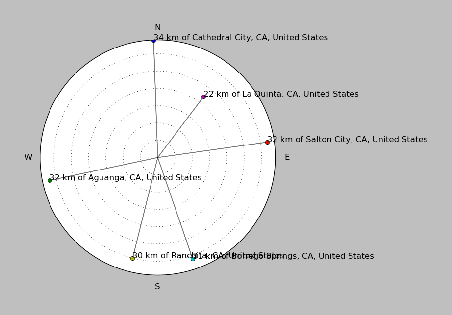
| ||||||||||||||||
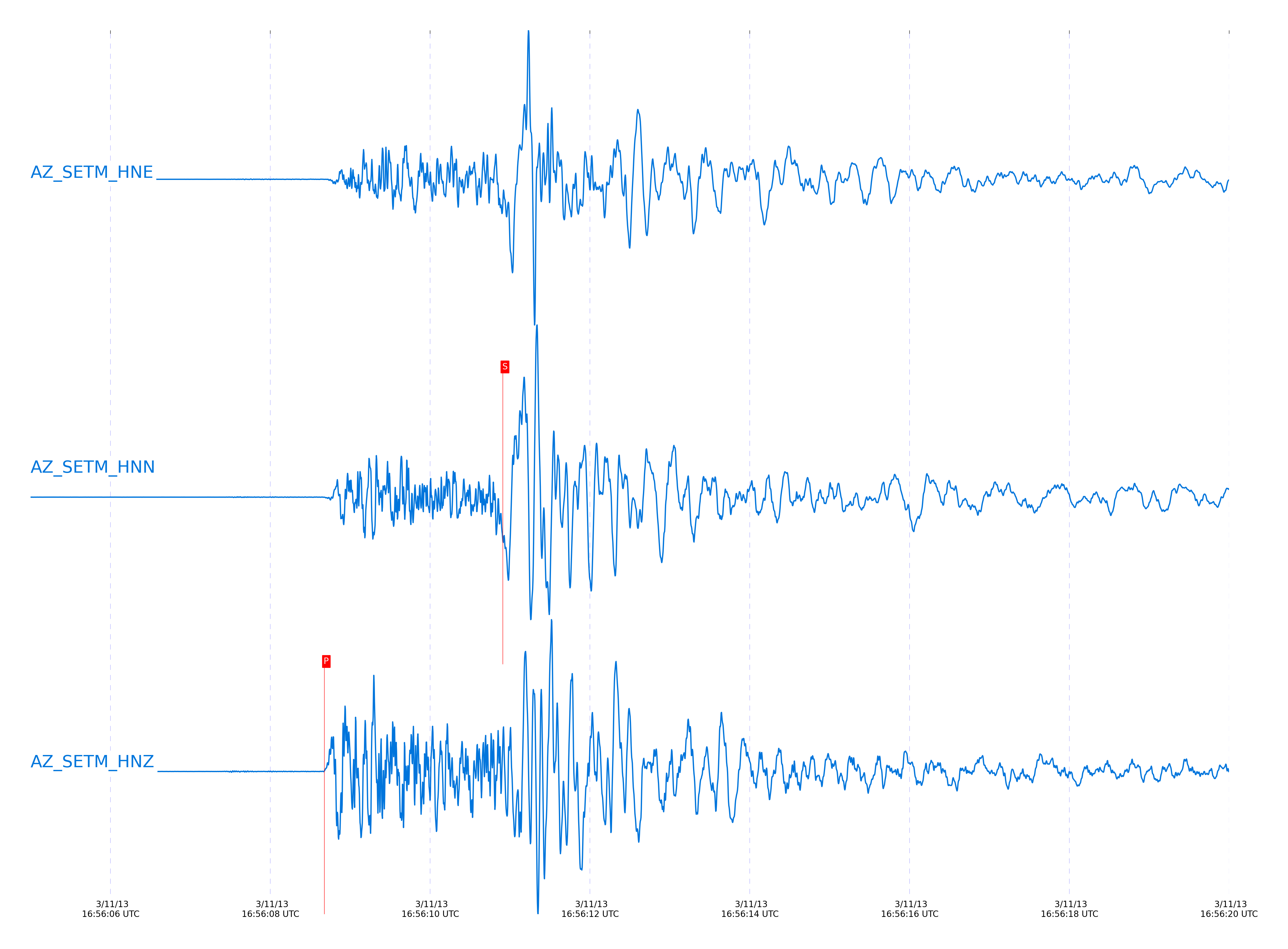
Event and active stations
|
|||||||||||||||||
Closest station with identified signal. Not filtered.
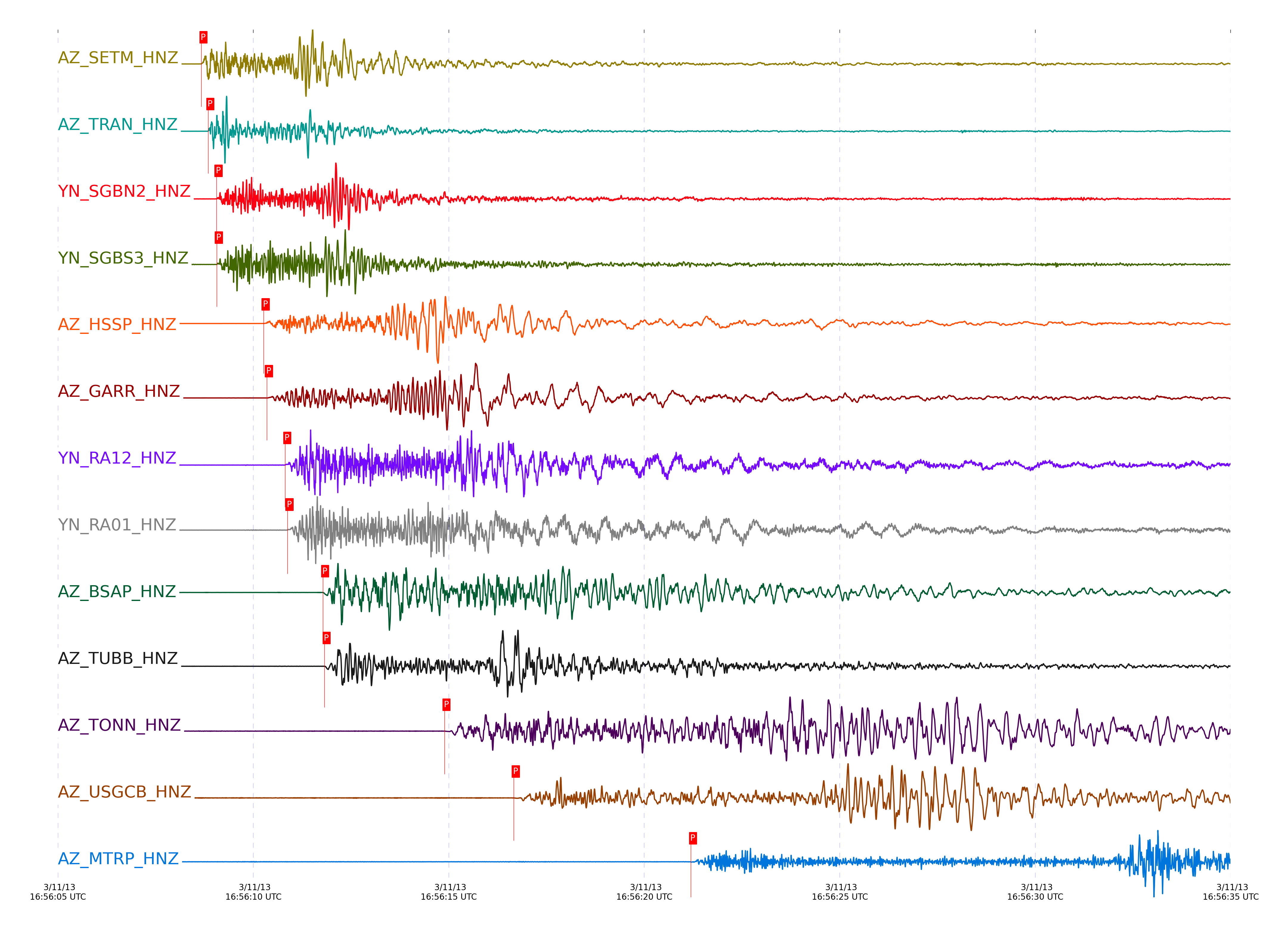
Subset of several stations close to the event. Not filtered.
| STA_CHAN | S-E Delta | S-E Azimuth | Phase | Time | Signal/Noise | Time Residual | V. Model | Auth | arid |
|---|---|---|---|---|---|---|---|---|---|
| TRO_HHZ | 0.033° | 234.24° | Pg | 2013-03-11 16:56:08.2284 UTC | 2714.5 | -0.097 | - | dbp:jtytell:130 | 24152 |
| TRO_HHE | 0.033° | 234.24° | Sg | 2013-03-11 16:56:09.9024 UTC | -1 | -0.184 | - | dbp:jtytell:130 | 24202 |
| TR01_HHZ | 0.089° | 335.42° | Pg | 2013-03-11 16:56:08.6969 UTC | 1168.1 | -0.122 | - | dbp:jtytell:130 | 24165 |
| TR01_HHE | 0.089° | 335.42° | Sg | 2013-03-11 16:56:10.9659 UTC | -1 | -0.044 | - | dbp:jtytell:130 | 24235 |
| TR02_HHZ | 0.092° | 338.16° | Pg | 2013-03-11 16:56:08.6884 UTC | -1 | -0.166 | - | dbp:jtytell:130 | 24161 |
| TR02_HHN | 0.092° | 338.16° | Sg | 2013-03-11 16:56:10.6978 UTC | -1 | -0.375 | - | dbp:jtytell:130 | 24216 |
| JFN4_HHZ | 0.093° | 329.05° | Pg | 2013-03-11 16:56:08.6885 UTC | -1 | -0.169 | - | dbp:jtytell:130 | 24162 |
| JFS4_HHZ | 0.093° | 331.05° | Pg | 2013-03-11 16:56:08.6735 UTC | -1 | -0.194 | - | dbp:jtytell:130 | 24159 |
| JFS4_HHE | 0.093° | 331.05° | Sg | 2013-03-11 16:56:10.8618 UTC | -1 | -0.232 | - | dbp:jtytell:130 | 24231 |
| JFN4_HHE | 0.093° | 329.05° | Sg | 2013-03-11 16:56:10.698 UTC | -1 | -0.38 | - | dbp:jtytell:130 | 24217 |
| TR03_HHZ | 0.099° | 342.98° | Pg | 2013-03-11 16:56:08.7324 UTC | -1 | -0.2 | - | dbp:jtytell:130 | 24172 |
| TR03_HHN | 0.099° | 342.98° | Sg | 2013-03-11 16:56:10.7599 UTC | -1 | -0.447 | - | dbp:jtytell:130 | 24219 |
| PFO_HHZ | 0.108° | 179.38° | Pg | 2013-03-11 16:56:08.7383 UTC | 909.17 | -0.304 | - | dbp:jtytell:130 | 24173 |
| PFO_HHE | 0.108° | 179.38° | Sg | 2013-03-11 16:56:10.7644 UTC | -1 | -0.631 | - | dbp:jtytell:130 | 24220 |
| TR04_HHZ | 0.109° | 345.77° | Pg | 2013-03-11 16:56:08.9863 UTC | -1 | -0.066 | - | dbp:jtytell:130 | 24175 |
| TFRD_HHZ | 0.121° | 85.59° | Pg | 2013-03-11 16:56:09.0566 UTC | -1 | -0.155 | - | dbp:jtytell:130 | 24180 |
| FRD_HHN | 0.121° | 85.54° | Sg | 2013-03-11 16:56:11.3742 UTC | -1 | -0.308 | - | dbp:jtytell:130 | 24240 |
| FRD_HHZ | 0.121° | 85.54° | Pg | 2013-03-11 16:56:09.0506 UTC | 1407 | -0.161 | - | dbp:jtytell:130 | 24179 |
| TFRD_HHN | 0.121° | 85.59° | Sg | 2013-03-11 16:56:11.4082 UTC | -1 | -0.274 | - | dbp:jtytell:130 | 24241 |
| SND_HHZ | 0.138° | 110.31° | Pg | 2013-03-11 16:56:09.3832 UTC | 673.52 | -0.068 | - | dbp:jtytell:130 | 24189 |
| SND_HHN | 0.138° | 110.31° | Sg | 2013-03-11 16:56:12.1353 UTC | -1 | 0.053 | - | dbp:jtytell:130 | 24259 |
| JORD_HHN | 0.159° | 78.42° | Sg | 2013-03-11 16:56:12.4959 UTC | -1 | -0.115 | - | dbp:jtytell:130 | 24263 |
| JORD_HHZ | 0.159° | 78.42° | Pg | 2013-03-11 16:56:09.6999 UTC | 550.18 | -0.072 | - | dbp:jtytell:130 | 24191 |
| BZN_HHZ | 0.175° | 85.84° | Pg | 2013-03-11 16:56:09.9439 UTC | -1 | -0.074 | - | dbp:jtytell:130 | 24203 |
| LVA2_HHE | 0.175° | 29.52° | Sg | 2013-03-11 16:56:12.9774 UTC | -1 | -0.046 | - | dbp:jtytell:130 | 24275 |
| LVA2_HHZ | 0.175° | 29.52° | Pg | 2013-03-11 16:56:09.9829 UTC | 537.14 | -0.042 | - | dbp:jtytell:130 | 24206 |
| BZN_HHN | 0.175° | 85.84° | Sg | 2013-03-11 16:56:12.9707 UTC | -1 | -0.041 | - | dbp:jtytell:130 | 24274 |
| WMC_HHE | 0.194° | 111.01° | Sg | 2013-03-11 16:56:13.6734 UTC | -1 | 0.159 | - | dbp:jtytell:130 | 24279 |
| WMC_HHZ | 0.194° | 111.01° | Pg | 2013-03-11 16:56:10.2792 UTC | 467.01 | -0.047 | - | dbp:jtytell:130 | 24212 |
| TMSP_HHE | 0.219° | 121.75° | Sg | 2013-03-11 16:56:14.4722 UTC | -1 | 0.267 | - | dbp:jtytell:130 | 24289 |
| TMSP_HHZ | 0.219° | 121.75° | Pg | 2013-03-11 16:56:10.7521 UTC | -1 | 0.005 | - | dbp:jtytell:130 | 24218 |
| CRY_HHZ | 0.241° | 104.7° | Pg | 2013-03-11 16:56:11.0099 UTC | -1 | -0.118 | - | dbp:jtytell:130 | 24236 |
| CRY_HHN | 0.241° | 104.7° | Sg | 2013-03-11 16:56:14.5834 UTC | -1 | -0.257 | - | dbp:jtytell:130 | 24291 |
| GVAR1_HHN | 0.263° | 128.02° | Sg | 2013-03-11 16:56:15.1291 UTC | -1 | -0.368 | - | dbp:jtytell:130 | 24306 |
| GVAR1_HHZ | 0.263° | 128.02° | Pg | 2013-03-11 16:56:11.1969 UTC | 245.44 | -0.32 | - | dbp:jtytell:130 | 24238 |
| RRSP_HHZ | 0.277° | 122.1° | Pg | 2013-03-11 16:56:11.6271 UTC | -1 | -0.134 | - | dbp:jtytell:130 | 24248 |
| RRSP_HHE | 0.277° | 122.1° | Sg | 2013-03-11 16:56:16.0249 UTC | -1 | 0.113 | - | dbp:jtytell:130 | 24311 |
| KNW_HHZ | 0.298° | 134.75° | Pg | 2013-03-11 16:56:11.7103 UTC | 141.57 | -0.424 | - | dbp:jtytell:130 | 24254 |
| KNW_HHE | 0.298° | 134.75° | Sg | 2013-03-11 16:56:15.9675 UTC | -1 | -0.585 | - | dbp:jtytell:130 | 24310 |
| RHIL_HHZ | 0.311° | 122.87° | Pg | 2013-03-11 16:56:12.2508 UTC | -1 | -0.115 | - | dbp:jtytell:130 | 24261 |
| RHIL_HHE | 0.311° | 122.87° | Sg | 2013-03-11 16:56:17.0966 UTC | -1 | 0.146 | - | dbp:jtytell:130 | 24320 |
| BCCC_HHZ | 0.327° | 115.84° | Pg | 2013-03-11 16:56:12.3214 UTC | -1 | -0.326 | - | dbp:jtytell:130 | 24262 |
| BCCC_HHN | 0.327° | 115.84° | Sg | 2013-03-11 16:56:17.0626 UTC | -1 | -0.376 | - | dbp:jtytell:130 | 24319 |
| IWR_HHZ | 0.342° | 131.08° | Pg | 2013-03-11 16:56:12.5466 UTC | -1 | -0.384 | - | dbp:jtytell:130 | 24269 |
| IWR_HHN | 0.342° | 131.08° | Sg | 2013-03-11 16:56:17.3977 UTC | -1 | -0.533 | - | dbp:jtytell:130 | 24321 |
| RDM_HHN | 0.348° | 111.1° | Sg | 2013-03-11 16:56:17.7492 UTC | -1 | -0.368 | - | dbp:jtytell:130 | 24332 |
| RDM_HHZ | 0.348° | 111.1° | Pg | 2013-03-11 16:56:12.6821 UTC | -1 | -0.355 | - | dbp:jtytell:130 | 24272 |
| SMER_HHZ | 0.596° | 85.35° | Pg | 2013-03-11 16:56:17.0384 UTC | 303.79 | -0.607 | - | dbp:jtytell:130 | 24318 |
| SMER_HHN | 0.596° | 85.35° | Sg | 2013-03-11 16:56:25.1713 UTC | -1 | -0.947 | - | dbp:jtytell:130 | 24357 |
| MONP2_HHE | 0.613° | 357.22° | Sg | 2013-03-11 16:56:25.6947 UTC | -1 | -0.957 | - | dbp:jtytell:130 | 24358 |
| MONP2_HHZ | 0.613° | 357.22° | Pg | 2013-03-11 16:56:17.4829 UTC | -1 | -0.472 | - | dbp:jtytell:130 | 24323 |
| HWB_HHZ | 0.636° | 41.14° | Pg | 2013-03-11 16:56:17.7234 UTC | -1 | -0.666 | - | dbp:jtytell:130 | 24330 |
| HWB_HHN | 0.636° | 41.14° | Sg | 2013-03-11 16:56:26.013 UTC | -1 | -1.388 | - | dbp:jtytell:130 | 24359 |
| CPE_HHZ | 0.819° | 41.18° | Pg | 2013-03-11 16:56:20.773 UTC | 244.35 | -1.092 | - | dbp:jtytell:130 | 24343 |
| CPE_HHN | 0.819° | 41.18° | Sg | 2013-03-11 16:56:31.3914 UTC | -1 | -2.005 | - | dbp:jtytell:130 | 24364 |
| SOL_HHZ | 0.936° | 44.71° | Pg | 2013-03-11 16:56:23.0895 UTC | 42.248 | -0.994 | - | dbp:jtytell:130 | 24351 |
| SOL_HHN | 0.936° | 44.71° | Sg | 2013-03-11 16:56:35.4391 UTC | -1 | -1.783 | - | dbp:jtytell:130 | 24371 |
| SCI2_HHZ | 1.798° | 70.32° | Pn | 2013-03-11 16:56:35.9558 UTC | 13.456 | -0.739 | - | dbp:jtytell:130 | 24372 |
Click the link below to observe an interactive map of earthquakes recorded by the station deployment:
Broadband Seismic Data Collection Center (ANZA),
Institute of Geophysics & Planetary Physics
Scripps Institution of Oceanography,
University of California San Diego
Copyright © 1989 - 2014. All Rights Reserved.