
last update to page: April 03 2018 17:24:16 (UTC).
SummaryThe red marker denotes the earthquake epicenter. On Mon Apr 2nd 2018 02:53:54 (UTC) the seismic network recorded an earthquake (preliminary 3.65 ml) located in Southern California. Seismic region California - Nevada Region. The epicentral distance (i.e. distance separating the location to the epicenter) to the closest station CRY in the network is 10.6 km. If you felt the quake, the USGS would like to know. Please add your comments to the USGS page "Did you feel it?". |
Details
Proximity to Population Centers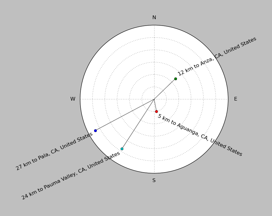
| ||||||||||||||||
Event and active stations
|
|||||||||||||||||
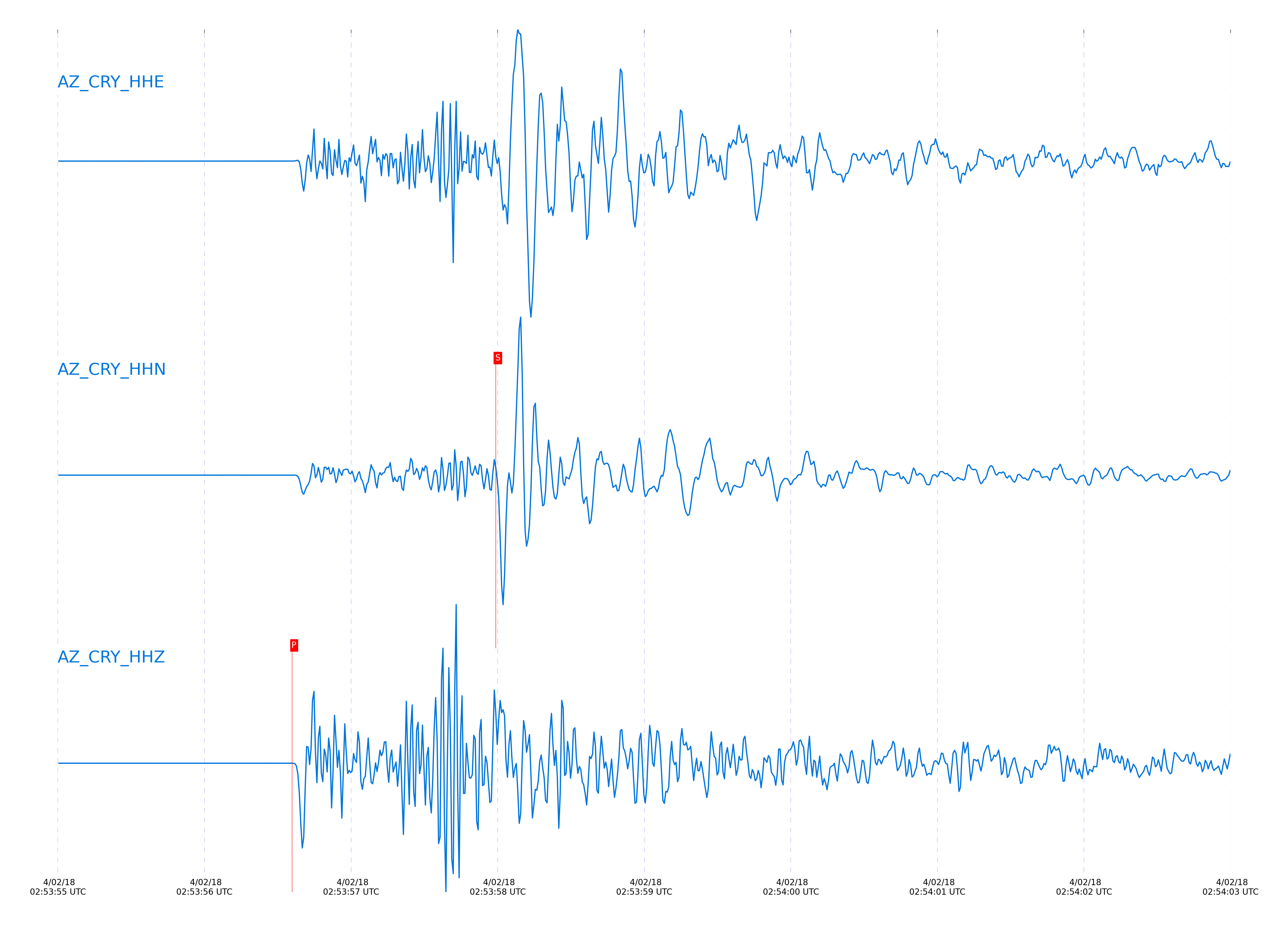
Closest station with identified signal. Not filtered.
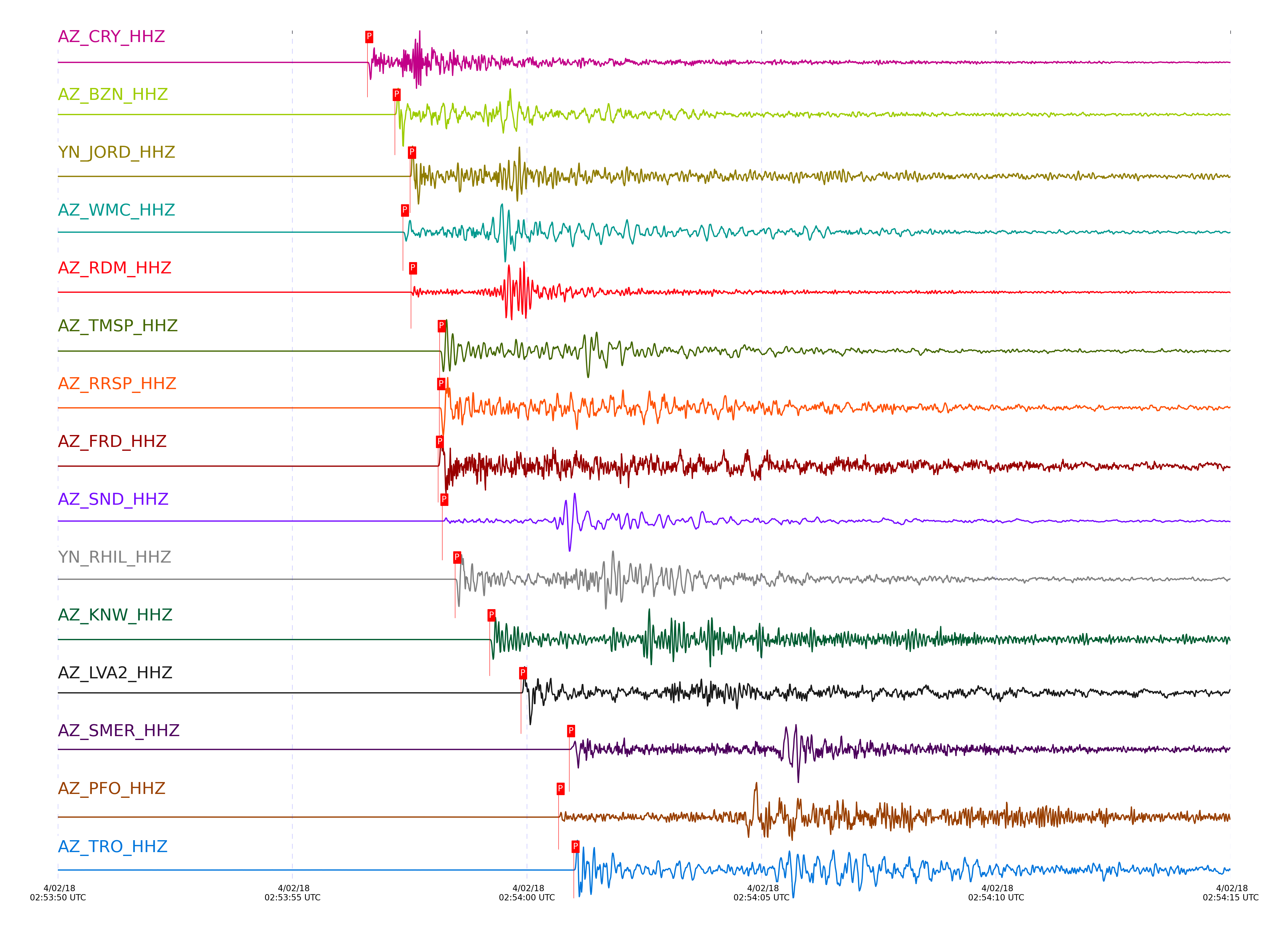
Subset of several stations close to the event. Not filtered.
| STA_CHAN | S-E Delta | S-E Azimuth | Phase | Time | Signal/Noise | Time Residual | V. Model | Auth | arid |
|---|---|---|---|---|---|---|---|---|---|
| CRY_HHZ | 0.095° | 219.45° | P | 2018-04-02 02:53:56.5984 UTC | 5862.2 | -0.094 | iasp91 | dbp:jtytell:180 | 1716267 |
| CRY_HHN | 0.095° | 219.45° | S | 2018-04-02 02:53:57.9869 UTC | -1 | -0.422 | iasp91 | dbp:jtytell:180 | 1716796 |
| BZN_HHZ | 0.119° | 270.29° | P | 2018-04-02 02:53:57.1826 UTC | 4309.3 | 0.131 | iasp91 | dbp:jtytell:180 | 1716269 |
| BZN_HHN | 0.119° | 270.29° | S | 2018-04-02 02:53:59.0754 UTC | -1 | 0.042 | iasp91 | dbp:jtytell:180 | 1716798 |
| JORD_HHZ | 0.139° | 278.25° | P | 2018-04-02 02:53:57.5084 UTC | 7529.3 | 0.115 | iasp91 | dbp:jtytell:180 | 1716273 |
| JORD_HHN | 0.139° | 278.25° | S | 2018-04-02 02:53:59.627 UTC | -1 | 0.012 | iasp91 | dbp:jtytell:180 | 1716799 |
| WMC_HHZ | 0.139° | 234.09° | P | 2018-04-02 02:53:57.3584 UTC | 3139.5 | -0.043 | iasp91 | dbp:jtytell:180 | 1716271 |
| WMC_HHE | 0.139° | 234.09° | S | 2018-04-02 02:53:59.2558 UTC | -1 | -0.373 | iasp91 | dbp:jtytell:180 | 1716800 |
| RDM_HHZ | 0.142° | 167.02° | P | 2018-04-02 02:53:57.5285 UTC | 6250.8 | 0.07 | iasp91 | dbp:jtytell:180 | 1716275 |
| RDM_HHE | 0.142° | 167.02° | S | 2018-04-02 02:53:59.5169 UTC | -1 | -0.213 | iasp91 | dbp:jtytell:180 | 1716801 |
| TMSP_HHZ | 0.167° | 220.19° | P | 2018-04-02 02:53:58.1386 UTC | -1 | 0.154 | iasp91 | dbp:jtytell:180 | 1716736 |
| RRSP_HHZ | 0.17° | 200.18° | P | 2018-04-02 02:53:58.1316 UTC | -1 | 0.139 | iasp91 | dbp:jtytell:180 | 1716737 |
| FRD_HHZ | 0.173° | 269.17° | P | 2018-04-02 02:53:58.1033 UTC | 3085.1 | 0.106 | iasp91 | dbp:jtytell:180 | 1716279 |
| FRD_HHE | 0.173° | 269.17° | S | 2018-04-02 02:54:00.4967 UTC | -1 | -0.151 | iasp91 | dbp:jtytell:180 | 1716808 |
| SND_HHZ | 0.175° | 250° | P | 2018-04-02 02:53:58.1974 UTC | 11941 | 0.149 | iasp91 | dbp:jtytell:180 | 1716281 |
| SND_HHE | 0.175° | 250° | S | 2018-04-02 02:54:00.7422 UTC | -1 | 0.003 | iasp91 | dbp:jtytell:180 | 1716809 |
| RHIL_HHZ | 0.184° | 190.02° | P | 2018-04-02 02:53:58.4712 UTC | -1 | 0.231 | iasp91 | dbp:jtytell:180 | 1716738 |
| RHIL_HHN | 0.184° | 190.02° | S | 2018-04-02 02:54:01.2771 UTC | -1 | 0.205 | iasp91 | dbp:jtytell:180 | 1716810 |
| GVAR1_HHZ | 0.194° | 206.26° | P | 2018-04-02 02:53:58.4672 UTC | -1 | 0.066 | iasp91 | dbp:jtytell:180 | 1716740 |
| KNW_HHZ | 0.237° | 200.16° | P | 2018-04-02 02:53:59.2031 UTC | 8927.7 | 0.003 | iasp91 | dbp:jtytell:180 | 1716285 |
| KNW_HHE | 0.237° | 200.16° | S | 2018-04-02 02:54:02.4391 UTC | -1 | -0.289 | iasp91 | dbp:jtytell:180 | 1716819 |
| LVA2_HHZ | 0.25° | 304.2° | P | 2018-04-02 02:53:59.8764 UTC | 5217 | 0.428 | iasp91 | dbp:jtytell:180 | 1716289 |
| LVA2_HHN | 0.25° | 304.2° | S | 2018-04-02 02:54:03.5921 UTC | -1 | 0.437 | iasp91 | dbp:jtytell:180 | 1716821 |
| SMER_HHZ | 0.303° | 83.4° | P | 2018-04-02 02:54:00.9011 UTC | 1747.5 | 0.575 | iasp91 | dbp:jtytell:180 | 1716297 |
| SMER_HHN | 0.303° | 83.4° | S | 2018-04-02 02:54:05.3797 UTC | -1 | 0.73 | iasp91 | dbp:jtytell:180 | 1716823 |
| PFO_HHZ | 0.316° | 247.8° | P | 2018-04-02 02:54:00.677 UTC | 918.58 | 0.022 | iasp91 | dbp:jtytell:180 | 1716294 |
| PFO_HHN | 0.316° | 247.8° | S | 2018-04-02 02:54:04.7942 UTC | -1 | -0.442 | iasp91 | dbp:jtytell:180 | 1716826 |
| TRO_HHZ | 0.322° | 264.51° | P | 2018-04-02 02:54:00.9958 UTC | 1834.6 | 0.08 | iasp91 | dbp:jtytell:180 | 1716298 |
| CPE_HHZ | 0.652° | 22.21° | P | 2018-04-02 02:54:06.7684 UTC | 261.7 | -0.168 | iasp91 | dbp:jtytell:180 | 1716307 |
| CPE_HHE | 0.652° | 22.21° | S | 2018-04-02 02:54:15.4822 UTC | -1 | -0.571 | iasp91 | dbp:jtytell:180 | 1716849 |
| MONP2_HHZ | 0.682° | 331.72° | P | 2018-04-02 02:54:07.7284 UTC | 385.82 | 0.039 | iasp91 | dbp:jtytell:180 | 1716310 |
| MONP2_HHN | 0.682° | 331.72° | S | 2018-04-02 02:54:17.0509 UTC | -1 | -0.34 | iasp91 | dbp:jtytell:180 | 1716850 |
Click the link below to observe an interactive map of earthquakes recorded by the station deployment:
Broadband Seismic Data Collection Center (ANZA),
Institute of Geophysics & Planetary Physics
Scripps Institution of Oceanography,
University of California San Diego
Copyright © 1989 - 2014. All Rights Reserved.