
last update to page: November 07 2018 17:40:24 (UTC).
SummaryThe red marker denotes the earthquake epicenter. On Mon Aug 20th 2018 15:44:54 (UTC) the seismic network recorded an earthquake (preliminary 3.05 ml) located in Southern California. Seismic region California - Nevada Region. The epicentral distance (i.e. distance separating the location to the epicenter) to the closest station CRY in the network is 10.9 km. If you felt the quake, the USGS would like to know. Please add your comments to the USGS page "Did you feel it?". |
Details
Proximity to Population Centers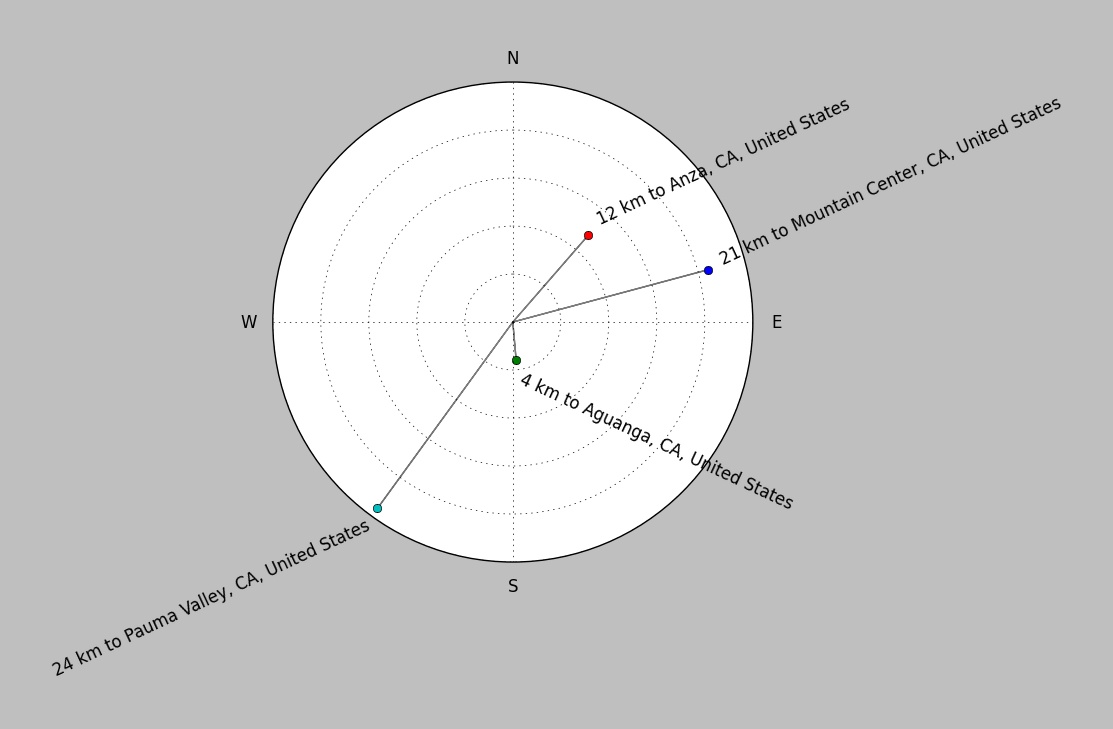
| ||||||||||||||||
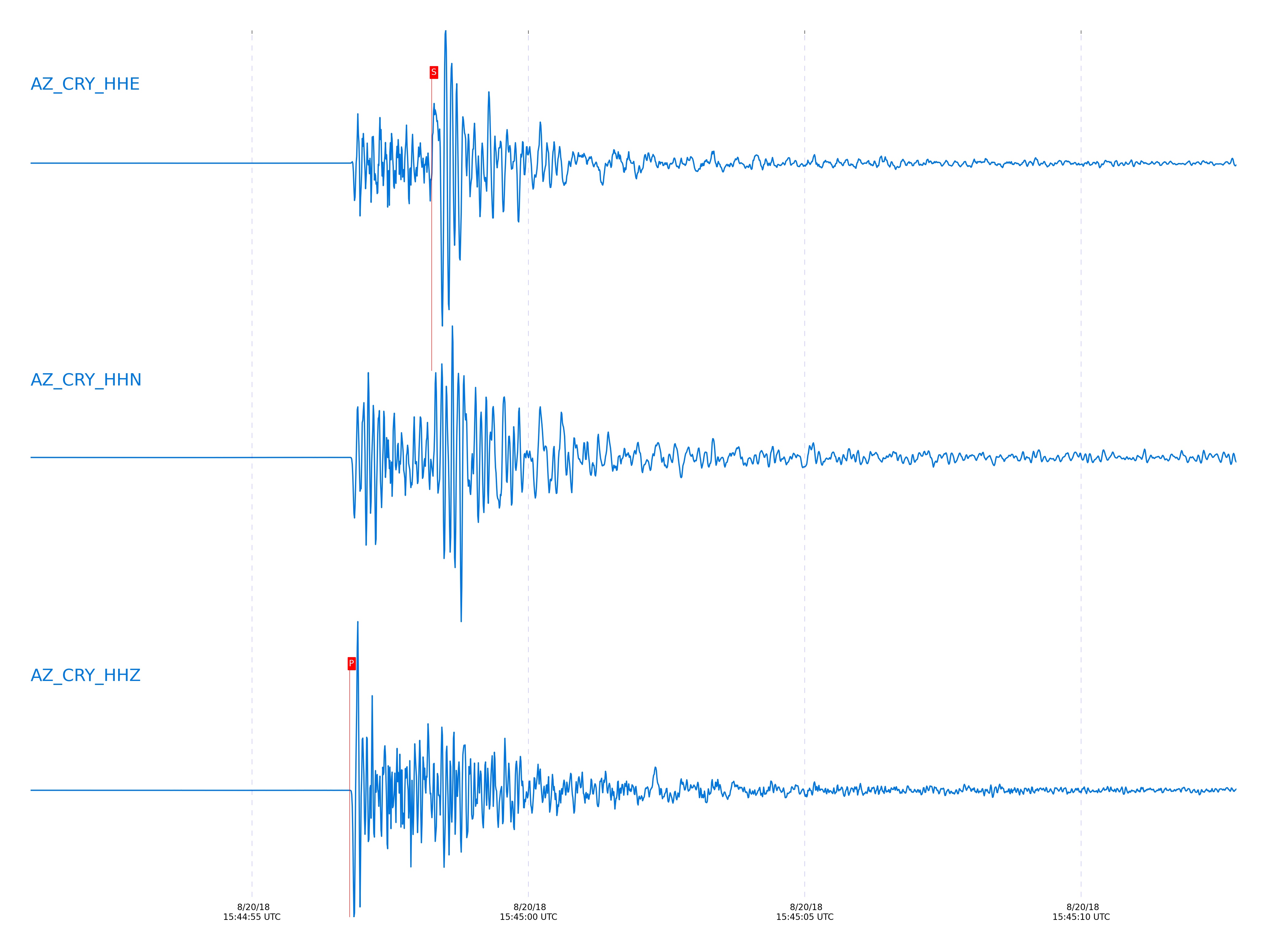
Event and active stations
|
|||||||||||||||||
Closest station with identified signal. Not filtered.
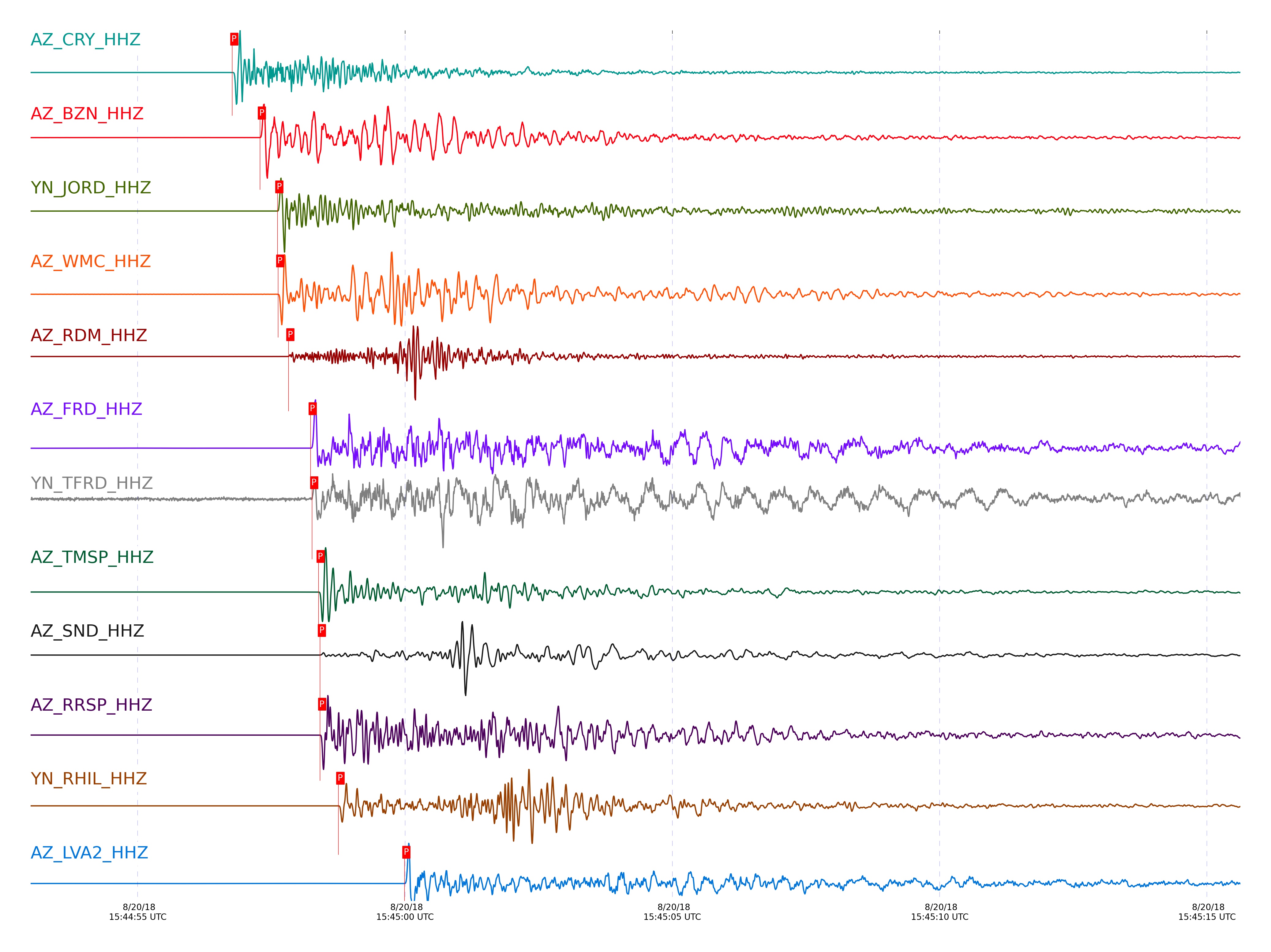
Subset of several stations close to the event. Not filtered.
| STA_CHAN | S-E Delta | S-E Azimuth | Phase | Time | Signal/Noise | Time Residual | V. Model | Auth | arid |
|---|---|---|---|---|---|---|---|---|---|
| CRY_HHZ | 0.098° | 214.12° | P | 2018-08-20 15:44:56.7684 UTC | 5844.8 | -0.13 | iasp91 | dbp:jtytell:182 | 1855331 |
| CRY_HHE | 0.098° | 214.12° | S | 2018-08-20 15:44:58.2529 UTC | -1 | -0.229 | iasp91 | dbp:jtytell:182 | 1861668 |
| BZN_HHZ | 0.114° | 266.59° | P | 2018-08-20 15:44:57.2884 UTC | 1492.4 | 0.132 | iasp91 | dbp:jtytell:182 | 1855333 |
| BZN_HHE | 0.114° | 266.59° | S | 2018-08-20 15:44:58.9864 UTC | -1 | 0.058 | iasp91 | dbp:jtytell:182 | 1861670 |
| JORD_HHZ | 0.132° | 275.46° | P | 2018-08-20 15:44:57.6145 UTC | 4310.2 | 0.118 | iasp91 | dbp:jtytell:182 | 1855335 |
| WMC_HHZ | 0.139° | 230.27° | P | 2018-08-20 15:44:57.6284 UTC | 483.54 | 0.002 | iasp91 | dbp:jtytell:182 | 1855337 |
| WMC_HHE | 0.139° | 230.27° | S | 2018-08-20 15:44:59.5582 UTC | -1 | -0.184 | iasp91 | dbp:jtytell:182 | 1861713 |
| RDM_HHZ | 0.15° | 165.53° | P | 2018-08-20 15:44:57.8184 UTC | 1512.6 | -0.024 | iasp91 | dbp:jtytell:182 | 1855339 |
| RDM_HHE | 0.15° | 165.53° | S | 2018-08-20 15:44:59.8497 UTC | -1 | -0.269 | iasp91 | dbp:jtytell:182 | 1861714 |
| FRD_HHZ | 0.168° | 266.63° | P | 2018-08-20 15:44:58.235 UTC | 1845.3 | 0.086 | iasp91 | dbp:jtytell:182 | 1855341 |
| TFRD_HHZ | 0.168° | 266.6° | P | 2018-08-20 15:44:58.2636 UTC | 15.72 | 0.132 | iasp91 | dbp:jtytell:182 | 1855343 |
| FRD_HHN | 0.168° | 266.63° | S | 2018-08-20 15:45:00.5292 UTC | -1 | -0.116 | iasp91 | dbp:jtytell:182 | 1861718 |
| TMSP_HHZ | 0.169° | 217.11° | P | 2018-08-20 15:44:58.385 UTC | 5187.6 | 0.12 | iasp91 | dbp:jtytell:182 | 1855345 |
| SND_HHZ | 0.172° | 247.06° | P | 2018-08-20 15:44:58.4084 UTC | 4649.3 | 0.156 | iasp91 | dbp:jtytell:182 | 1855347 |
| SND_HHE | 0.172° | 247.06° | S | 2018-08-20 15:45:00.9533 UTC | -1 | 0.125 | iasp91 | dbp:jtytell:182 | 1861719 |
| RRSP_HHZ | 0.175° | 197.6° | P | 2018-08-20 15:44:58.4129 UTC | 4241.9 | 0.078 | iasp91 | dbp:jtytell:182 | 1855349 |
| RHIL_HHZ | 0.191° | 187.95° | P | 2018-08-20 15:44:58.7545 UTC | 2662.1 | 0.138 | iasp91 | dbp:jtytell:182 | 1855356 |
| RHIL_HHE | 0.191° | 187.95° | S | 2018-08-20 15:45:01.4965 UTC | -1 | 0.035 | iasp91 | dbp:jtytell:182 | 1861720 |
| KNW_HHE | 0.242° | 198.3° | S | 2018-08-20 15:45:02.7821 UTC | -1 | -0.34 | iasp91 | dbp:jtytell:182 | 1861723 |
| LVA2_HHZ | 0.242° | 303.52° | P | 2018-08-20 15:44:59.9911 UTC | 4369 | 0.423 | iasp91 | dbp:jtytell:182 | 1855366 |
| KNW_HHZ | 0.242° | 198.3° | P | 2018-08-20 15:44:59.4907 UTC | 1946.5 | -0.088 | iasp91 | dbp:jtytell:182 | 1855360 |
| SMER_HHZ | 0.308° | 84.87° | P | 2018-08-20 15:45:01.1484 UTC | 367.46 | 0.426 | iasp91 | dbp:jtytell:182 | 1855372 |
| SMER_HHN | 0.308° | 84.87° | S | 2018-08-20 15:45:05.6297 UTC | -1 | 0.559 | iasp91 | dbp:jtytell:182 | 1861726 |
| PFO_HHN | 0.313° | 246.17° | S | 2018-08-20 15:45:05.0559 UTC | -1 | -0.361 | iasp91 | dbp:jtytell:182 | 1861729 |
| PFO_HHZ | 0.313° | 246.17° | P | 2018-08-20 15:45:00.9284 UTC | 357.55 | 0.017 | iasp91 | dbp:jtytell:182 | 1855370 |
| TRO_HHZ | 0.317° | 263.09° | P | 2018-08-20 15:45:01.1965 UTC | 381.2 | 0.073 | iasp91 | dbp:jtytell:182 | 1855374 |
| CPE_HHE | 0.647° | 22.92° | S | 2018-08-20 15:45:15.7881 UTC | -1 | -0.428 | iasp91 | dbp:jtytell:182 | 1861740 |
| CPE_HHZ | 0.647° | 22.92° | P | 2018-08-20 15:45:06.9381 UTC | 30.449 | -0.244 | iasp91 | dbp:jtytell:182 | 1855375 |
| MONP2_HHZ | 0.673° | 331.85° | P | 2018-08-20 15:45:07.8621 UTC | 79.4 | 0.015 | iasp91 | dbp:jtytell:182 | 1855387 |
| MONP2_HHN | 0.673° | 331.85° | S | 2018-08-20 15:45:16.8249 UTC | -1 | -0.578 | iasp91 | dbp:jtytell:182 | 1861742 |
Click the link below to observe an interactive map of earthquakes recorded by the station deployment:
Broadband Seismic Data Collection Center (ANZA),
Institute of Geophysics & Planetary Physics
Scripps Institution of Oceanography,
University of California San Diego
Copyright © 1989 - 2014. All Rights Reserved.