
last update to page: March 15 2016 17:13:14 (UTC).
SummaryThe red marker denotes the earthquake epicenter. On Sun May 31st 2015 13:02:55 (UTC) the seismic network recorded an earthquake (preliminary 4.07 ml) located in Southern California. Seismic region California - Nevada Region. The epicentral distance (i.e. distance separating the location to the epicenter) to the closest station BVDA2 in the network is 5.7 km. If you felt the quake, the USGS would like to know. Please add your comments to the USGS page "Did you feel it?". |
Details
Proximity to Population Centers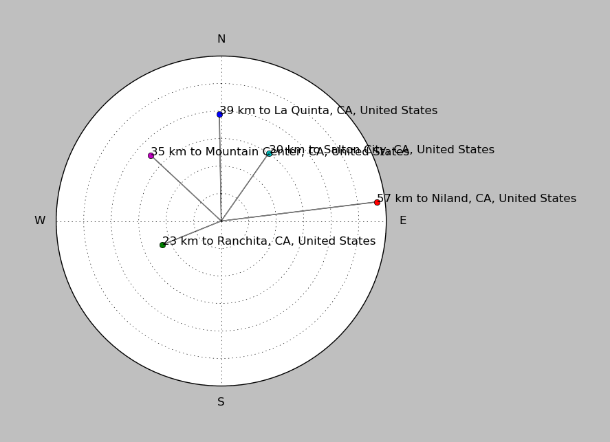
| ||||||||||||||||
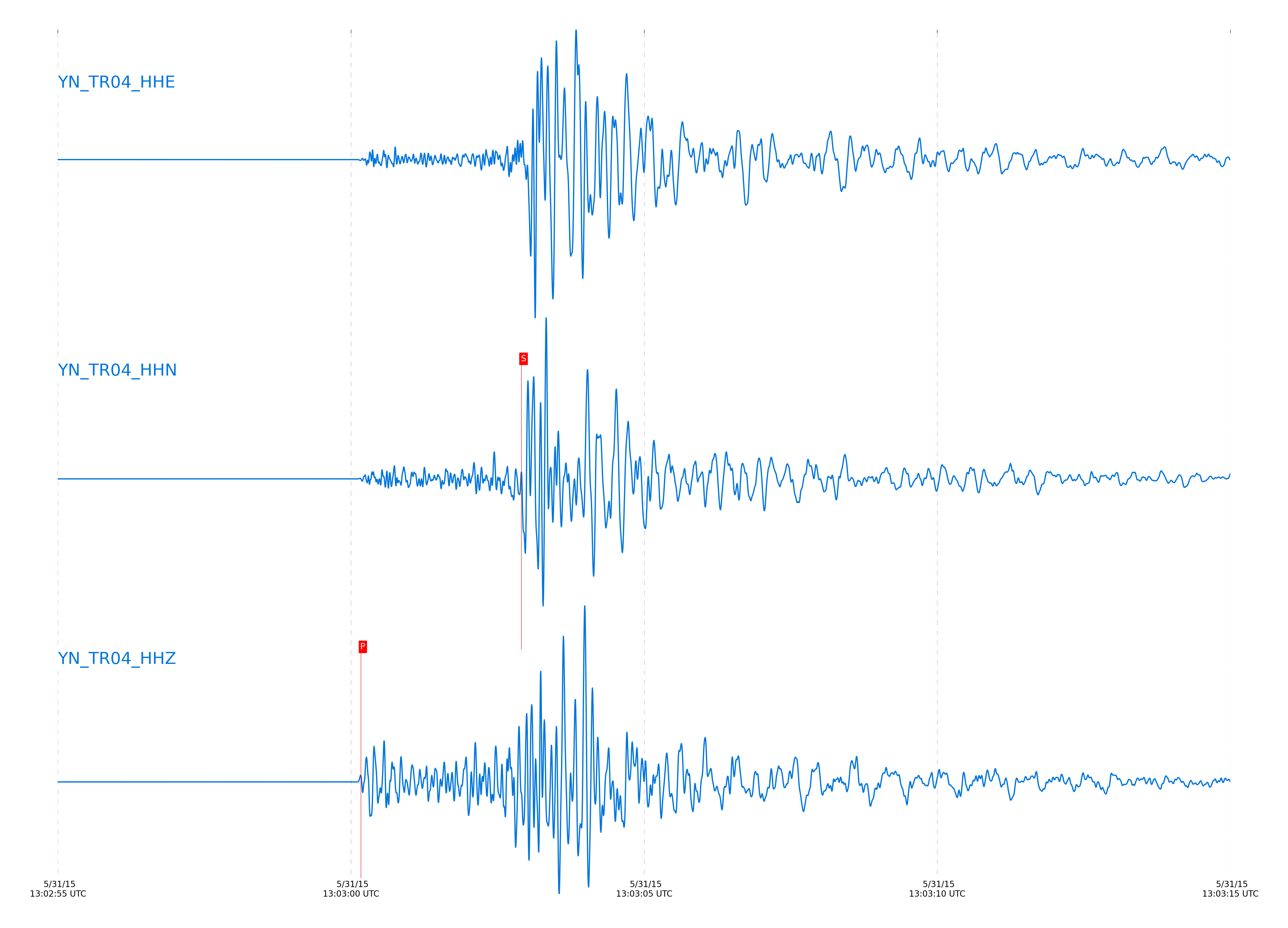
Event and active stations
|
|||||||||||||||||
Closest station with identified signal. Not filtered.
Subset of several stations close to the event. Not filtered.
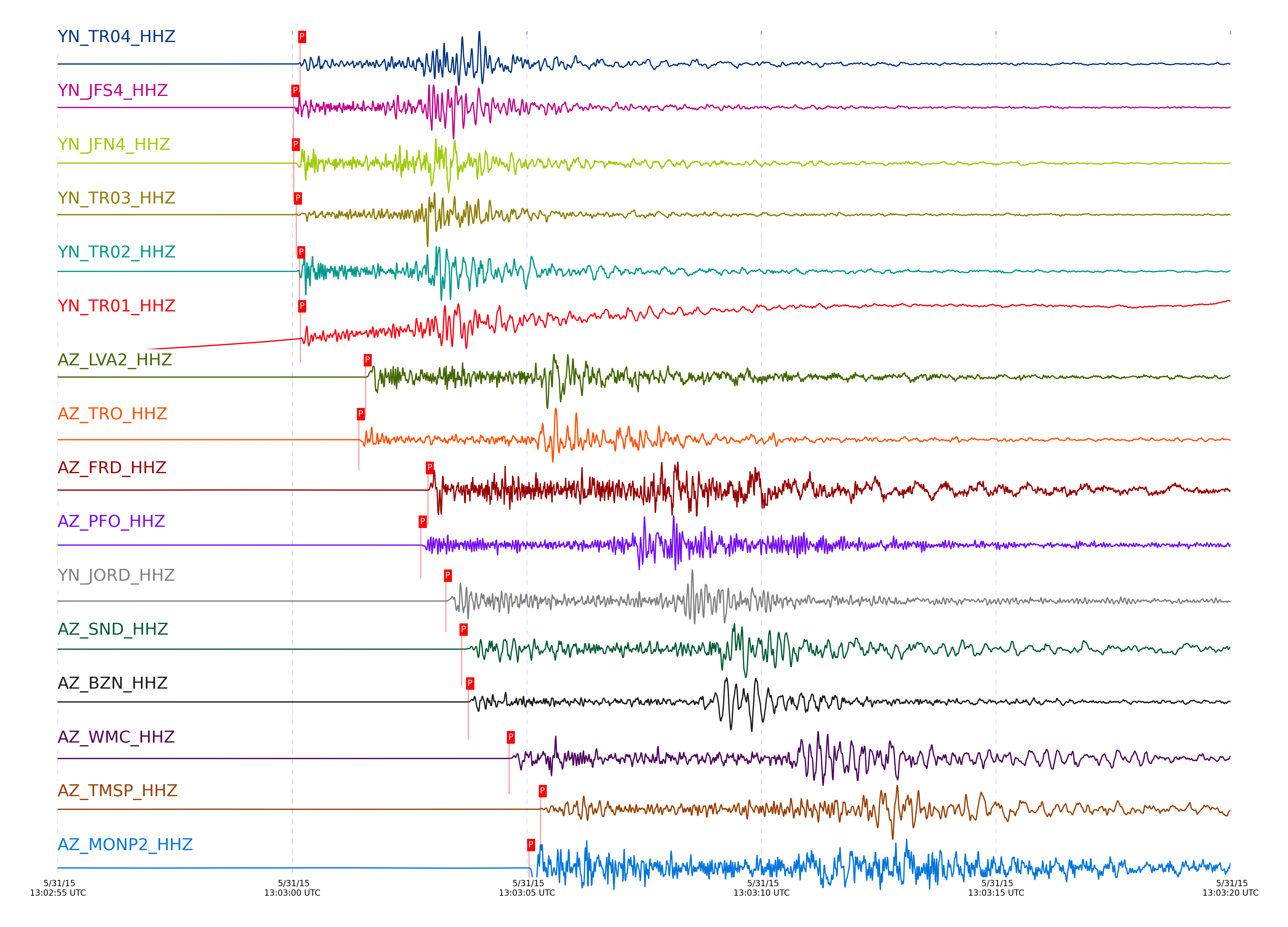
| STA_CHAN | S-E Delta | S-E Azimuth | Phase | Time | Signal/Noise | Time Residual | V. Model | Auth | arid |
|---|---|---|---|---|---|---|---|---|---|
| TR04_HHN | 0.13° | 129.49° | S | 2015-05-31 13:03:02.9059 UTC | -1 | -0.014 | iasp91 | dbp:rt:15151 | 725984 |
| TR04_HHZ | 0.13° | 129.49° | P | 2015-05-31 13:03:00.1676 UTC | -1 | 0.198 | iasp91 | dbp:rt:15151 | 725954 |
| JFN4_HHZ | 0.134° | 143.88° | P | 2015-05-31 13:03:00.0325 UTC | -1 | 0.028 | iasp91 | dbp:rt:15151 | 725951 |
| JFS4_HHZ | 0.134° | 142.46° | P | 2015-05-31 13:03:00.0222 UTC | -1 | 0.024 | iasp91 | dbp:rt:15151 | 725950 |
| JFN4_HHE | 0.134° | 143.88° | S | 2015-05-31 13:03:02.8773 UTC | -1 | -0.106 | iasp91 | dbp:rt:15151 | 725982 |
| JFS4_HHE | 0.134° | 142.46° | S | 2015-05-31 13:03:02.7453 UTC | -1 | -0.227 | iasp91 | dbp:rt:15151 | 725978 |
| TR03_HHZ | 0.135° | 133.62° | P | 2015-05-31 13:03:00.0803 UTC | -1 | 0.052 | iasp91 | dbp:rt:15151 | 725952 |
| TR03_HHN | 0.135° | 133.62° | S | 2015-05-31 13:03:02.7274 UTC | -1 | -0.299 | iasp91 | dbp:rt:15151 | 725976 |
| TR02_HHZ | 0.138° | 137.84° | P | 2015-05-31 13:03:00.1491 UTC | -1 | 0.085 | iasp91 | dbp:rt:15151 | 725953 |
| TR02_HHE | 0.138° | 137.84° | S | 2015-05-31 13:03:02.857 UTC | -1 | -0.233 | iasp91 | dbp:rt:15151 | 725980 |
| TR01_HHE | 0.139° | 139.96° | S | 2015-05-31 13:03:03.0933 UTC | -1 | -0.035 | iasp91 | dbp:rt:15151 | 725987 |
| TR01_HHZ | 0.139° | 139.96° | P | 2015-05-31 13:03:00.1695 UTC | 418.28 | 0.084 | iasp91 | socal | 725955 |
| LVA2_HHZ | 0.216° | 99.3° | P | 2015-05-31 13:03:01.5653 UTC | 1319.6 | 0.336 | iasp91 | dbp:rt:15151 | 725963 |
| LVA2_HHN | 0.216° | 99.3° | S | 2015-05-31 13:03:05.4598 UTC | -1 | 0.31 | iasp91 | dbp:rt:15151 | 726013 |
| TRO_HHN | 0.23° | 154.29° | S | 2015-05-31 13:03:05.1632 UTC | -1 | -0.665 | iasp91 | dbp:rt:15151 | 726006 |
| TRO_HHZ | 0.23° | 154.29° | P | 2015-05-31 13:03:01.4184 UTC | 275.92 | -0.191 | iasp91 | socal | 725961 |
| FRD_HHZ | 0.305° | 125.75° | P | 2015-05-31 13:03:02.8884 UTC | 1280.3 | 0.277 | iasp91 | socal | 725983 |
| TFRD_HHE | 0.305° | 125.77° | S | 2015-05-31 13:03:07.5235 UTC | -1 | 0.03 | iasp91 | dbp:rt:15151 | 726040 |
| FRD_HHE | 0.305° | 125.75° | S | 2015-05-31 13:03:07.553 UTC | -1 | 0.021 | iasp91 | dbp:rt:15151 | 726041 |
| TFRD_HHZ | 0.305° | 125.77° | P | 2015-05-31 13:03:02.9291 UTC | -1 | 0.338 | iasp91 | dbp:rt:15151 | 725985 |
| PFO_HHZ | 0.322° | 156.59° | P | 2015-05-31 13:03:02.7384 UTC | 4148 | -0.18 | iasp91 | socal | 725977 |
| PFO_HHE | 0.322° | 156.59° | S | 2015-05-31 13:03:07.3646 UTC | -1 | -0.688 | iasp91 | dbp:rt:15151 | 726037 |
| JORD_HHN | 0.323° | 118.77° | S | 2015-05-31 13:03:08.2081 UTC | -1 | 0.13 | iasp91 | dbp:rt:15151 | 726043 |
| JORD_HHZ | 0.323° | 118.77° | P | 2015-05-31 13:03:03.2745 UTC | 11957 | 0.341 | iasp91 | socal | 725989 |
| BZN_HHZ | 0.348° | 120.09° | P | 2015-05-31 13:03:03.7484 UTC | 1425.6 | 0.366 | iasp91 | socal | 725993 |
| SND_HHZ | 0.348° | 132.56° | P | 2015-05-31 13:03:03.6084 UTC | 2995.2 | 0.229 | iasp91 | socal | 725991 |
| SND_HHN | 0.348° | 132.56° | S | 2015-05-31 13:03:09.1624 UTC | -1 | 0.325 | iasp91 | dbp:rt:15151 | 726053 |
| BZN_HHE | 0.348° | 120.09° | S | 2015-05-31 13:03:08.9086 UTC | -1 | 0.068 | iasp91 | dbp:rt:15151 | 726050 |
| WMC_HHZ | 0.401° | 129.83° | P | 2015-05-31 13:03:04.6184 UTC | 1217.8 | 0.323 | iasp91 | socal | 726000 |
| WMC_HHE | 0.401° | 129.83° | S | 2015-05-31 13:03:10.6497 UTC | -1 | 0.255 | iasp91 | dbp:rt:15151 | 726060 |
| TMSP_HHE | 0.435° | 134.01° | S | 2015-05-31 13:03:11.9133 UTC | -1 | 0.278 | iasp91 | dbp:rt:15151 | 726073 |
| TMSP_HHZ | 0.435° | 134.01° | P | 2015-05-31 13:03:05.2956 UTC | -1 | 0.289 | iasp91 | dbp:rt:15151 | 726009 |
| MONP2_HHE | 0.436° | 12.84° | S | 2015-05-31 13:03:11.1259 UTC | -1 | -0.476 | iasp91 | dbp:rt:15151 | 726067 |
| MONP2_HHZ | 0.436° | 12.84° | P | 2015-05-31 13:03:05.0484 UTC | 1822.3 | 0.059 | iasp91 | socal | 726005 |
| CRY_HHZ | 0.437° | 124.59° | P | 2015-05-31 13:03:05.2584 UTC | 2315.5 | 0.322 | iasp91 | socal | 726008 |
| CRY_HHN | 0.437° | 124.59° | S | 2015-05-31 13:03:11.4331 UTC | -1 | -0.063 | iasp91 | dbp:rt:15151 | 726071 |
| GVAR1_HHZ | 0.484° | 136.25° | P | 2015-05-31 13:03:05.9995 UTC | 38.63 | 0.208 | iasp91 | socal | 726021 |
| GVAR1_HHE | 0.484° | 136.25° | S | 2015-05-31 13:03:12.6716 UTC | -1 | -0.305 | iasp91 | dbp:rt:15151 | 726081 |
| RRSP_HHE | 0.493° | 132.74° | S | 2015-05-31 13:03:13.665 UTC | -1 | 0.343 | iasp91 | dbp:rt:15151 | 726089 |
| RRSP_HHZ | 0.493° | 132.74° | P | 2015-05-31 13:03:06.1801 UTC | -1 | 0.191 | iasp91 | dbp:rt:15151 | 726022 |
| KNW_HHE | 0.522° | 139.52° | S | 2015-05-31 13:03:13.4751 UTC | -1 | -0.743 | iasp91 | dbp:rt:15151 | 726086 |
| KNW_HHZ | 0.522° | 139.52° | P | 2015-05-31 13:03:06.3484 UTC | 595.37 | -0.158 | iasp91 | socal | 726025 |
| BCCC_HHZ | 0.535° | 128.02° | P | 2015-05-31 13:03:06.8095 UTC | 1033.2 | 0.147 | iasp91 | socal | 726030 |
| BCCC_HHE | 0.535° | 128.02° | S | 2015-05-31 13:03:14.3931 UTC | -1 | -0.09 | iasp91 | dbp:rt:15151 | 726092 |
| RDM_HHE | 0.55° | 124.63° | S | 2015-05-31 13:03:14.6866 UTC | -1 | -0.377 | iasp91 | dbp:rt:15151 | 726094 |
| RDM_HHZ | 0.55° | 124.63° | P | 2015-05-31 13:03:07.0284 UTC | 1109.3 | 0.037 | iasp91 | socal | 726032 |
| SMER_HHZ | 0.736° | 100.84° | P | 2015-05-31 13:03:10.1384 UTC | 704.51 | -0.032 | iasp91 | socal | 726057 |
| SMER_HHE | 0.736° | 100.84° | S | 2015-05-31 13:03:20.2851 UTC | -1 | -0.3 | iasp91 | dbp:rt:15151 | 726111 |
| CPE_HHZ | 0.794° | 57.2° | P | 2015-05-31 13:03:11.1084 UTC | 879.51 | -0.072 | iasp91 | socal | 726066 |
| CPE_HHE | 0.794° | 57.2° | S | 2015-05-31 13:03:21.7348 UTC | -1 | -0.593 | iasp91 | dbp:rt:15151 | 726115 |
| SOL_HHZ | 0.921° | 58.67° | P | 2015-05-31 13:03:13.4784 UTC | 137.28 | 0.095 | iasp91 | socal | 726087 |
| SOL_HHE | 0.921° | 58.67° | S | 2015-05-31 13:03:26.1238 UTC | -1 | -0.032 | iasp91 | dbp:rt:15151 | 726122 |
Click the link below to observe an interactive map of earthquakes recorded by the station deployment:
Broadband Seismic Data Collection Center (ANZA),
Institute of Geophysics & Planetary Physics
Scripps Institution of Oceanography,
University of California San Diego
Copyright © 1989 - 2014. All Rights Reserved.