
last update to page: March 15 2016 18:03:53 (UTC).
SummaryThe red marker denotes the earthquake epicenter. On Sun Sep 13th 2015 08:14:12 (UTC) the seismic network recorded an earthquake (preliminary 6.6 mwp) located in Gulf Of California. Seismic region Baja California And Gulf Of California. The epicentral distance (i.e. distance separating the location to the epicenter) to the closest station USGCB in the network is 1,092.1 km. If you felt the quake, the USGS would like to know. Please add your comments to the USGS page "Did you feel it?". |
Details
Proximity to Population Centers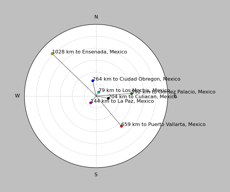
| ||||||||||||||||
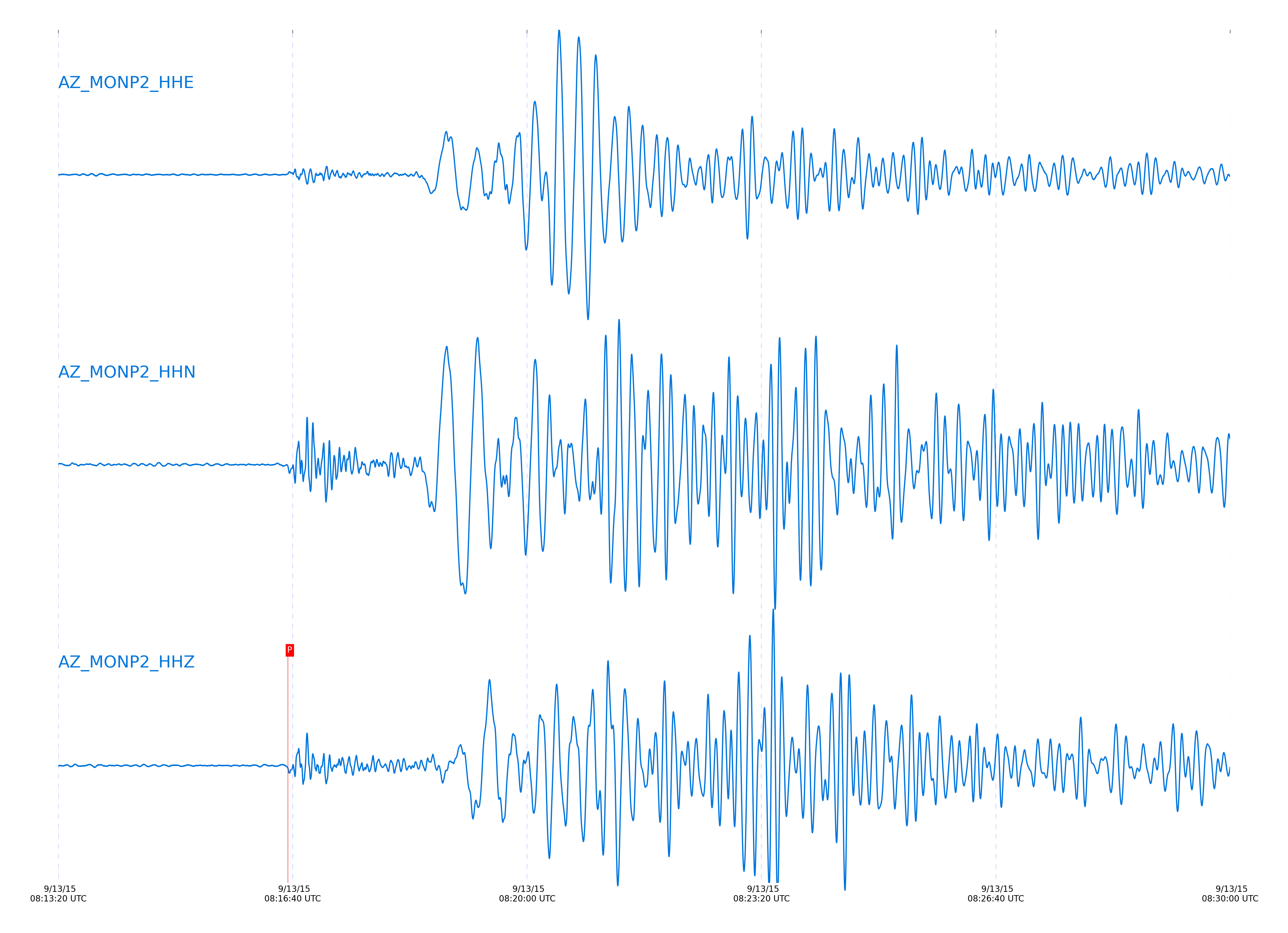
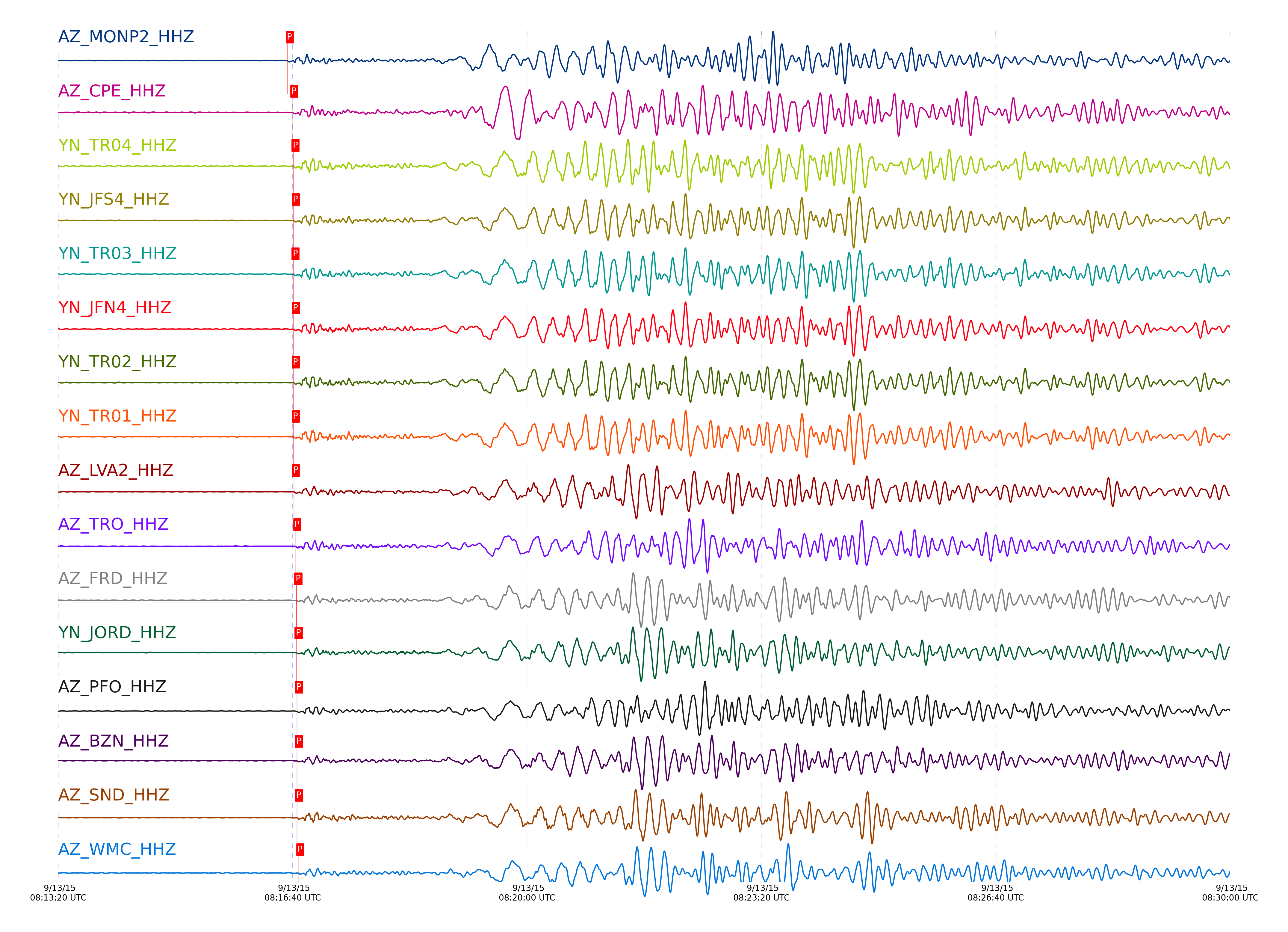
Event and active stations
|
|||||||||||||||||
Closest station with identified signal. Not filtered.
Subset of several stations close to the event. Not filtered.
| STA_CHAN | S-E Delta | S-E Azimuth | Phase | Time | Signal/Noise | Time Residual | V. Model | Auth | arid |
|---|---|---|---|---|---|---|---|---|---|
| MONP2_HHZ | 9.883° | 139.7° | Pn | 2015-09-13 08:16:35.9222 UTC | 146.77 | 1.12 | iasp91 | dbp:jtytell:152 | 769231 |
| CPE_HHZ | 10.262° | 136.91° | Pn | 2015-09-13 08:16:39.7967 UTC | 55.944 | -0.199 | iasp91 | dbp:jtytell:152 | 769239 |
| TR04_HHZ | 10.277° | 141.49° | Pn | 2015-09-13 08:16:40.9367 UTC | -1 | 0.743 | iasp91 | dbp:jtytell:152 | 769242 |
| TR03_HHZ | 10.284° | 141.54° | Pn | 2015-09-13 08:16:40.9377 UTC | -1 | 0.648 | iasp91 | dbp:jtytell:152 | 769243 |
| JFS4_HHZ | 10.284° | 141.67° | Pn | 2015-09-13 08:16:41.041 UTC | -1 | 0.753 | iasp91 | dbp:jtytell:152 | 769244 |
| JFN4_HHZ | 10.284° | 141.69° | Pn | 2015-09-13 08:16:41.0463 UTC | -1 | 0.754 | iasp91 | dbp:jtytell:152 | 769245 |
| TR02_HHZ | 10.287° | 141.6° | Pn | 2015-09-13 08:16:41.0865 UTC | -1 | 0.749 | iasp91 | dbp:jtytell:152 | 769246 |
| TR01_HHZ | 10.289° | 141.63° | Pn | 2015-09-13 08:16:41.1142 UTC | 135.19 | 0.751 | iasp91 | dbp:jtytell:152 | 769247 |
| LVA2_HHZ | 10.311° | 140.77° | Pn | 2015-09-13 08:16:41.171 UTC | 85.66 | 0.508 | iasp91 | dbp:jtytell:152 | 769248 |
| TRO_HHZ | 10.375° | 141.92° | Pn | 2015-09-13 08:16:42.2996 UTC | 89.268 | 0.769 | iasp91 | dbp:jtytell:152 | 769253 |
| FRD_HHZ | 10.444° | 141.1° | Pn | 2015-09-13 08:16:43.2987 UTC | 116.65 | 0.821 | iasp91 | dbp:jtytell:152 | 769258 |
| JORD_HHZ | 10.449° | 140.85° | Pn | 2015-09-13 08:16:43.5477 UTC | 94.847 | 1.001 | iasp91 | dbp:jtytell:152 | 769261 |
| PFO_HHZ | 10.461° | 142.08° | Pn | 2015-09-13 08:16:43.7916 UTC | 137.03 | 1.071 | iasp91 | dbp:jtytell:152 | 769265 |
| BZN_HHZ | 10.475° | 140.82° | Pn | 2015-09-13 08:16:43.8132 UTC | 79.169 | 0.903 | iasp91 | dbp:jtytell:152 | 769266 |
| SND_HHZ | 10.494° | 141.25° | Pn | 2015-09-13 08:16:43.8976 UTC | 117.76 | 0.733 | iasp91 | dbp:jtytell:152 | 769268 |
| WMC_HHZ | 10.543° | 141.07° | Pn | 2015-09-13 08:16:44.9515 UTC | 107.3 | 1.113 | iasp91 | dbp:jtytell:152 | 769275 |
| CRY_HHZ | 10.57° | 140.79° | Pn | 2015-09-13 08:16:44.9099 UTC | 101.26 | 0.709 | iasp91 | dbp:jtytell:152 | 769274 |
| TMSP_HHZ | 10.582° | 141.2° | Pn | 2015-09-13 08:16:45.3927 UTC | -1 | 1.024 | iasp91 | dbp:jtytell:152 | 769277 |
| RRSP_HHZ | 10.638° | 141.07° | pPn | 2015-09-13 08:16:46.3441 UTC | -1 | -1.199 | iasp91 | dbp:jtytell:152 | 769280 |
| BCCC_HHZ | 10.671° | 140.77° | pPn | 2015-09-13 08:16:46.8885 UTC | 131 | -1.118 | iasp91 | dbp:jtytell:152 | 769284 |
| KNW_HHZ | 10.672° | 141.39° | Pn | 2015-09-13 08:16:46.6401 UTC | 102.73 | 1.036 | iasp91 | dbp:jtytell:152 | 769283 |
| RDM_HHZ | 10.678° | 140.57° | Pn | 2015-09-13 08:16:46.4796 UTC | 103.26 | 0.796 | iasp91 | dbp:jtytell:152 | 769281 |
| SMER_HHZ | 10.721° | 138.71° | Pn | 2015-09-13 08:16:46.2837 UTC | 84.709 | 0.01 | iasp91 | dbp:jtytell:152 | 769278 |
| SCI2_HHZ | 11.11° | 131.95° | Pn | 2015-09-13 08:16:50.4612 UTC | 12.359 | -1.144 | iasp91 | dbp:jtytell:152 | 769291 |
Click the link below to observe an interactive map of earthquakes recorded by the station deployment:
Broadband Seismic Data Collection Center (ANZA),
Institute of Geophysics & Planetary Physics
Scripps Institution of Oceanography,
University of California San Diego
Copyright © 1989 - 2014. All Rights Reserved.