
last update to page: March 15 2016 22:05:02 (UTC).
SummaryThe red marker denotes the earthquake epicenter. On Mon Oct 26th 2015 09:09:32 (UTC) the seismic network recorded an earthquake (preliminary 7.5 mww) located in Hindu Kush Region, Afghanistan. Seismic region Hindu Kush And Pamir. The epicentral distance (i.e. distance separating the location to the epicenter) to the closest station CSLB in the network is 12,167.0 km. If you felt the quake, the USGS would like to know. Please add your comments to the USGS page "Did you feel it?". |
Details
Proximity to Population Centers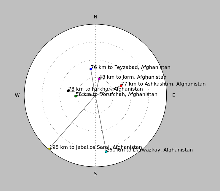
| ||||||||||||||||
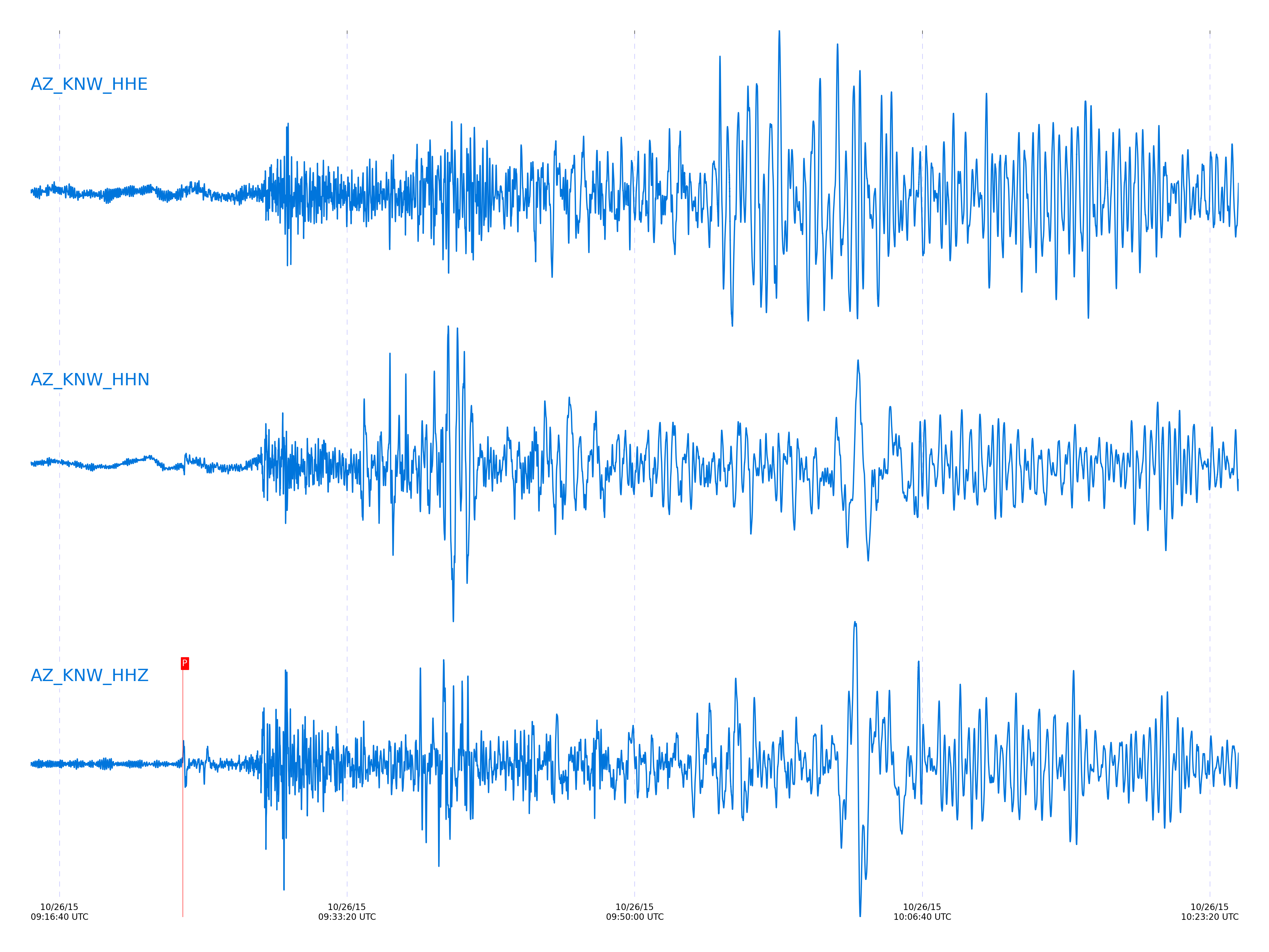
Event and active stations
|
|||||||||||||||||
Closest station with identified signal. Not filtered.
Subset of several stations close to the event. Not filtered.
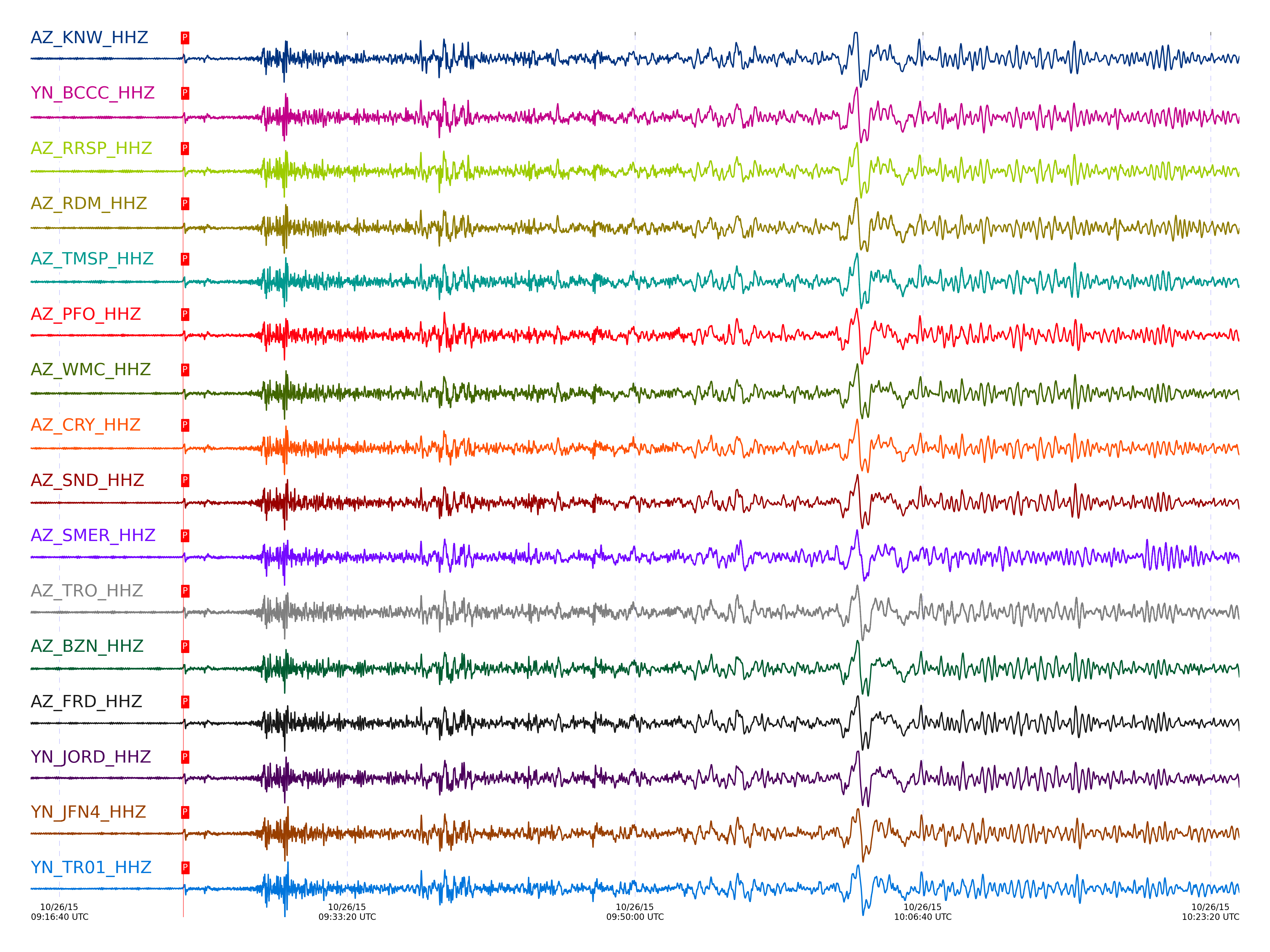
| STA_CHAN | S-E Delta | S-E Azimuth | Phase | Time | Signal/Noise | Time Residual | V. Model | Auth | arid |
|---|---|---|---|---|---|---|---|---|---|
| KNW_HHZ | 109.504° | 353.66° | Pdiff | 2015-10-26 09:23:49.1289 UTC | -1 | 13.65 | iasp91 | dbp:jtytell:152 | 783933 |
| BCCC_HHZ | 109.561° | 353.58° | Pdiff | 2015-10-26 09:23:49.5531 UTC | -1 | 13.819 | iasp91 | dbp:jtytell:152 | 783945 |
| RRSP_HHZ | 109.563° | 353.64° | Pdiff | 2015-10-26 09:23:48.768 UTC | -1 | 13.025 | iasp91 | dbp:jtytell:152 | 783930 |
| RDM_HHZ | 109.575° | 353.55° | Pdiff | 2015-10-26 09:23:49.4205 UTC | -1 | 13.627 | iasp91 | dbp:jtytell:152 | 783942 |
| TMSP_HHZ | 109.601° | 353.69° | Pdiff | 2015-10-26 09:23:49.1542 UTC | -1 | 13.244 | iasp91 | dbp:jtytell:152 | 783934 |
| PFO_HHZ | 109.628° | 353.88° | Pdiff | 2015-10-26 09:23:49.3637 UTC | -1 | 13.332 | iasp91 | dbp:jtytell:152 | 783939 |
| WMC_HHZ | 109.647° | 353.69° | Pdiff | 2015-10-26 09:23:49.3985 UTC | -1 | 13.285 | iasp91 | dbp:jtytell:152 | 783941 |
| CRY_HHZ | 109.649° | 353.64° | Pdiff | 2015-10-26 09:23:49.5608 UTC | -1 | 13.437 | iasp91 | dbp:jtytell:152 | 783946 |
| SND_HHZ | 109.674° | 353.74° | Pdiff | 2015-10-26 09:23:49.9232 UTC | -1 | 13.689 | iasp91 | dbp:jtytell:152 | 783954 |
| SMER_HHZ | 109.715° | 353.27° | Pdiff | 2015-10-26 09:23:49.2114 UTC | -1 | 12.795 | iasp91 | dbp:jtytell:152 | 783935 |
| TRO_HHZ | 109.719° | 353.9° | Pdiff | 2015-10-26 09:23:50.1661 UTC | -1 | 13.731 | iasp91 | dbp:jtytell:152 | 783961 |
| BZN_HHZ | 109.729° | 353.69° | Pdiff | 2015-10-26 09:23:49.7115 UTC | -1 | 13.233 | iasp91 | dbp:jtytell:152 | 783950 |
| FRD_HHZ | 109.732° | 353.75° | Pdiff | 2015-10-26 09:23:50.0322 UTC | -1 | 13.541 | iasp91 | dbp:jtytell:152 | 783957 |
| JORD_HHZ | 109.75° | 353.71° | Pdiff | 2015-10-26 09:23:49.5937 UTC | -1 | 13.021 | iasp91 | dbp:jtytell:152 | 783947 |
| JFN4_HHZ | 109.819° | 353.92° | Pdiff | 2015-10-26 09:23:49.7243 UTC | -1 | 12.844 | iasp91 | dbp:jtytell:152 | 783951 |
| TR01_HHZ | 109.82° | 353.91° | Pdiff | 2015-10-26 09:23:50.8301 UTC | -1 | 13.947 | iasp91 | dbp:jtytell:152 | 783971 |
| JFS4_HHZ | 109.821° | 353.92° | Pdiff | 2015-10-26 09:23:50.5171 UTC | -1 | 13.628 | iasp91 | dbp:jtytell:152 | 783965 |
| TR02_HHZ | 109.824° | 353.9° | Pdiff | 2015-10-26 09:23:50.6803 UTC | -1 | 13.778 | iasp91 | dbp:jtytell:152 | 783969 |
| TR03_HHZ | 109.832° | 353.9° | Pdiff | 2015-10-26 09:23:50.5379 UTC | -1 | 13.6 | iasp91 | dbp:jtytell:152 | 783966 |
| TR04_HHZ | 109.843° | 353.9° | Pdiff | 2015-10-26 09:23:51.031 UTC | -1 | 14.047 | iasp91 | dbp:jtytell:152 | 783972 |
| LVA2_HHZ | 109.878° | 353.78° | Pdiff | 2015-10-26 09:23:50.6232 UTC | -1 | 13.484 | iasp91 | dbp:jtytell:152 | 783968 |
| CPE_HHZ | 110.286° | 353.3° | Pdiff | 2015-10-26 09:23:51.8681 UTC | -1 | 12.916 | iasp91 | dbp:jtytell:152 | 783976 |
| SOL_HHZ | 110.32° | 353.17° | Pdiff | 2015-10-26 09:23:52.0892 UTC | -1 | 12.989 | iasp91 | dbp:jtytell:152 | 783978 |
| MONP2_HHZ | 110.347° | 353.88° | Pdiff | 2015-10-26 09:23:51.6678 UTC | -1 | 12.445 | iasp91 | dbp:jtytell:152 | 783974 |
Click the link below to observe an interactive map of earthquakes recorded by the station deployment:
Broadband Seismic Data Collection Center (ANZA),
Institute of Geophysics & Planetary Physics
Scripps Institution of Oceanography,
University of California San Diego
Copyright © 1989 - 2014. All Rights Reserved.