
last update to page: March 15 2016 22:37:24 (UTC).
SummaryThe red marker denotes the earthquake epicenter. On Thu Dec 17th 2015 19:49:54 (UTC) the seismic network recorded an earthquake (preliminary 6.6 mww) located in Near Coast Of Chiapas, Mexico. Seismic region Mexico - Guatemala Area. The epicentral distance (i.e. distance separating the location to the epicenter) to the closest station USGCB in the network is 2,970.7 km. If you felt the quake, the USGS would like to know. Please add your comments to the USGS page "Did you feel it?". |
Details
Proximity to Population Centers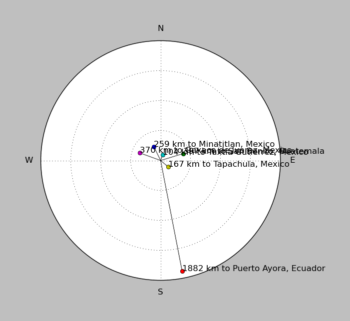
| ||||||||||||||||
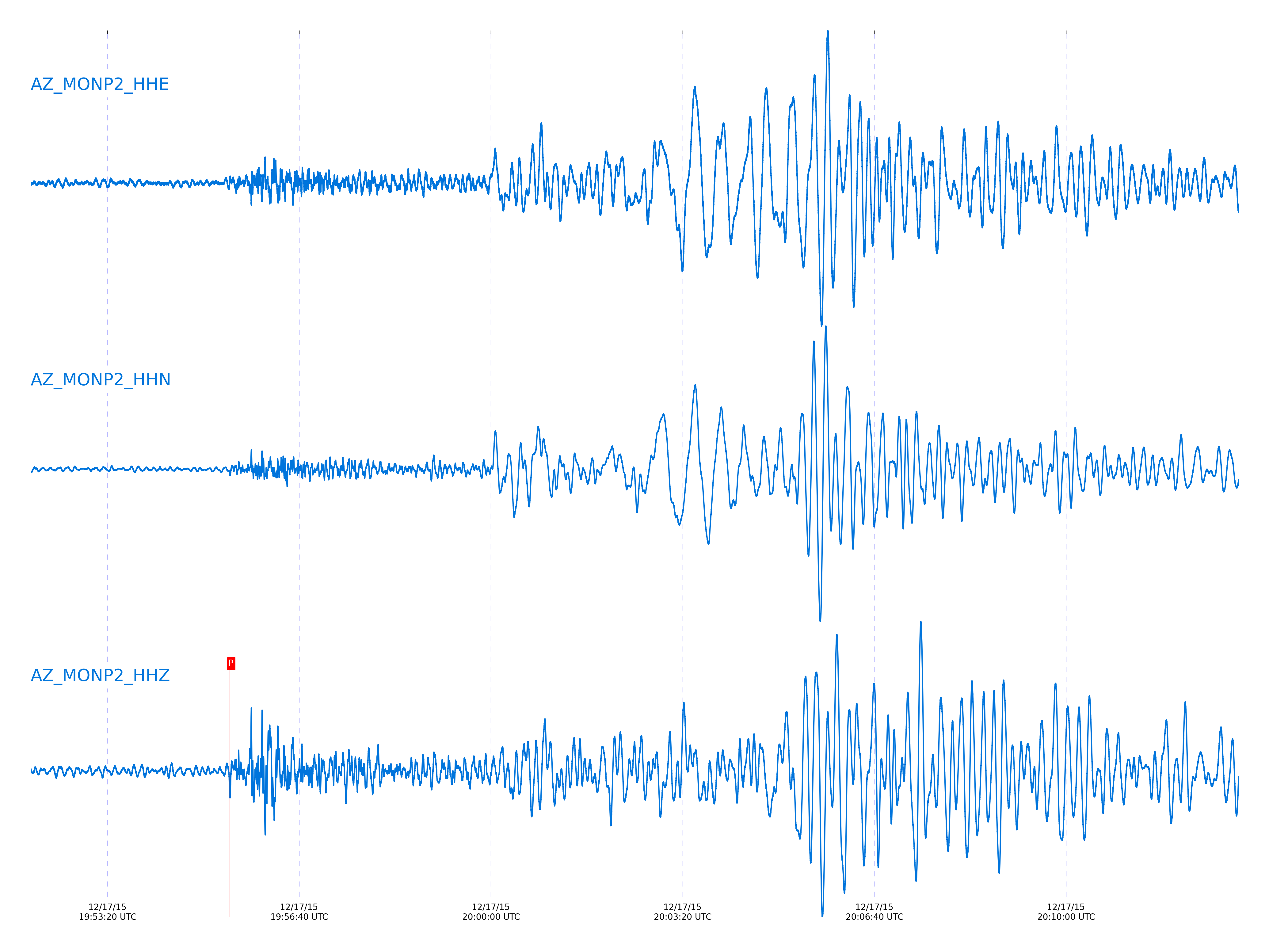
Event and active stations
|
|||||||||||||||||
Closest station with identified signal. Not filtered.
Subset of several stations close to the event. Not filtered.
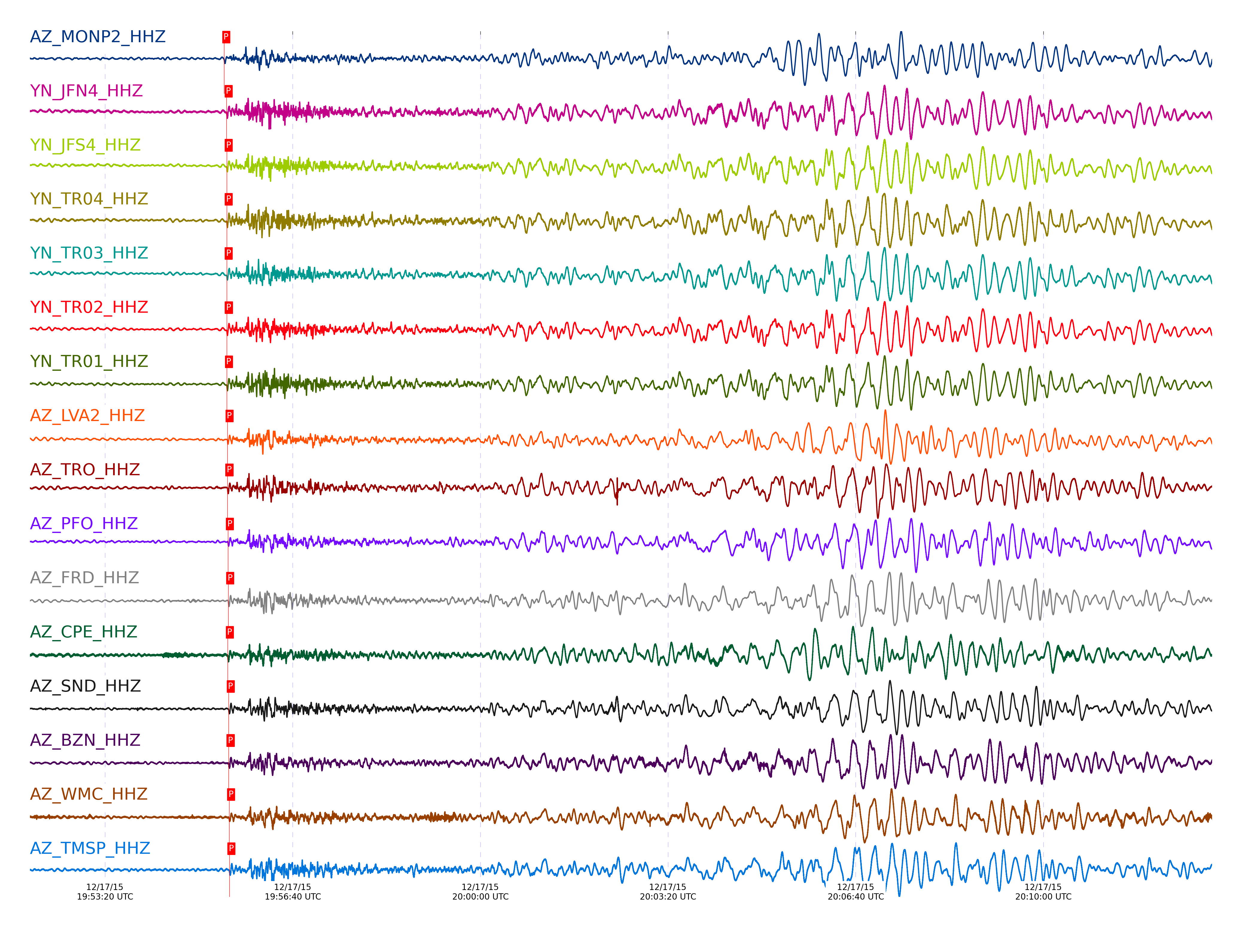
| STA_CHAN | S-E Delta | S-E Azimuth | Phase | Time | Signal/Noise | Time Residual | V. Model | Auth | arid |
|---|---|---|---|---|---|---|---|---|---|
| MONP2_HHZ | 26.842° | 123.81° | P | 2015-12-17 19:55:26.9553 UTC | -1 | 0.679 | iasp91 | dbp:jtytell:153 | 803432 |
| JFN4_HHZ | 27.127° | 124.71° | P | 2015-12-17 19:55:29.6176 UTC | -1 | 0.789 | iasp91 | dbp:jtytell:153 | 803434 |
| JFS4_HHZ | 27.128° | 124.7° | P | 2015-12-17 19:55:29.6236 UTC | -1 | 0.789 | iasp91 | dbp:jtytell:153 | 803435 |
| TR04_HHZ | 27.13° | 124.63° | P | 2015-12-17 19:55:29.6396 UTC | -1 | 0.788 | iasp91 | dbp:jtytell:153 | 803436 |
| TR03_HHZ | 27.134° | 124.65° | P | 2015-12-17 19:55:29.6776 UTC | -1 | 0.788 | iasp91 | dbp:jtytell:153 | 803437 |
| TR02_HHZ | 27.134° | 124.67° | P | 2015-12-17 19:55:29.7336 UTC | -1 | 0.839 | iasp91 | dbp:jtytell:153 | 803438 |
| TR01_HHZ | 27.135° | 124.68° | P | 2015-12-17 19:55:29.8894 UTC | 35.702 | 0.992 | iasp91 | dbp:jtytell:153 | 803439 |
| LVA2_HHZ | 27.196° | 124.35° | P | 2015-12-17 19:55:30.4853 UTC | 25.164 | 1.039 | iasp91 | dbp:jtytell:153 | 803445 |
| TRO_HHZ | 27.2° | 124.83° | P | 2015-12-17 19:55:30.427 UTC | 38.367 | 0.942 | iasp91 | dbp:jtytell:153 | 803443 |
| PFO_HHZ | 27.274° | 124.92° | P | 2015-12-17 19:55:30.9323 UTC | 21.733 | 0.79 | iasp91 | dbp:jtytell:153 | 803453 |
| FRD_HHZ | 27.305° | 124.52° | P | 2015-12-17 19:55:31.3079 UTC | 32.513 | 0.887 | iasp91 | dbp:jtytell:153 | 803457 |
| CPE_HHZ | 27.32° | 122.82° | P | 2015-12-17 19:55:30.8572 UTC | 12.148 | 0.308 | iasp91 | dbp:jtytell:153 | 803450 |
| SND_HHZ | 27.345° | 124.6° | P | 2015-12-17 19:55:31.7657 UTC | 14.118 | 0.99 | iasp91 | dbp:jtytell:153 | 803461 |
| BZN_HHZ | 27.348° | 124.42° | P | 2015-12-17 19:55:31.6883 UTC | 20.726 | 0.886 | iasp91 | dbp:jtytell:153 | 803460 |
| WMC_HHZ | 27.4° | 124.54° | P | 2015-12-17 19:55:32.2027 UTC | 17.271 | 0.938 | iasp91 | dbp:jtytell:153 | 803462 |
| TMSP_HHZ | 27.43° | 124.6° | P | 2015-12-17 19:55:32.5231 UTC | -1 | 0.989 | iasp91 | dbp:jtytell:153 | 803465 |
| CRY_HHZ | 27.438° | 124.44° | P | 2015-12-17 19:55:32.3912 UTC | 20.581 | 0.784 | iasp91 | dbp:jtytell:153 | 803463 |
| RRSP_HHZ | 27.488° | 124.57° | P | 2015-12-17 19:55:32.9932 UTC | -1 | 0.938 | iasp91 | dbp:jtytell:153 | 803468 |
| KNW_HHZ | 27.505° | 124.71° | P | 2015-12-17 19:55:33.4494 UTC | -1 | 1.244 | iasp91 | dbp:jtytell:153 | 803471 |
| RHIL_HHZ | 27.522° | 124.56° | P | 2015-12-17 19:55:33.2979 UTC | -1 | 0.938 | iasp91 | dbp:jtytell:153 | 803470 |
| BCCC_HHZ | 27.535° | 124.46° | P | 2015-12-17 19:55:33.1507 UTC | 24.169 | 0.682 | iasp91 | dbp:jtytell:153 | 803469 |
| RDM_HHZ | 27.55° | 124.38° | P | 2015-12-17 19:55:33.4952 UTC | 23.58 | 0.884 | iasp91 | dbp:jtytell:153 | 803472 |
| SMER_HHZ | 27.677° | 123.64° | P | 2015-12-17 19:55:33.9051 UTC | 24.932 | 0.164 | iasp91 | dbp:jtytell:153 | 803473 |
Click the link below to observe an interactive map of earthquakes recorded by the station deployment:
Broadband Seismic Data Collection Center (ANZA),
Institute of Geophysics & Planetary Physics
Scripps Institution of Oceanography,
University of California San Diego
Copyright © 1989 - 2014. All Rights Reserved.