
last update to page: March 15 2016 23:04:03 (UTC).
SummaryThe red marker denotes the earthquake epicenter. On Sun Dec 27th 2015 19:24:56 (UTC) the seismic network recorded an earthquake (preliminary 4.9 mb) located in North Pacific Ocean. Seismic region Pacific Basin. The epicentral distance (i.e. distance separating the location to the epicenter) to the closest station SCI2 in the network is 838.2 km. If you felt the quake, the USGS would like to know. Please add your comments to the USGS page "Did you feel it?". |
Details
Proximity to Population Centers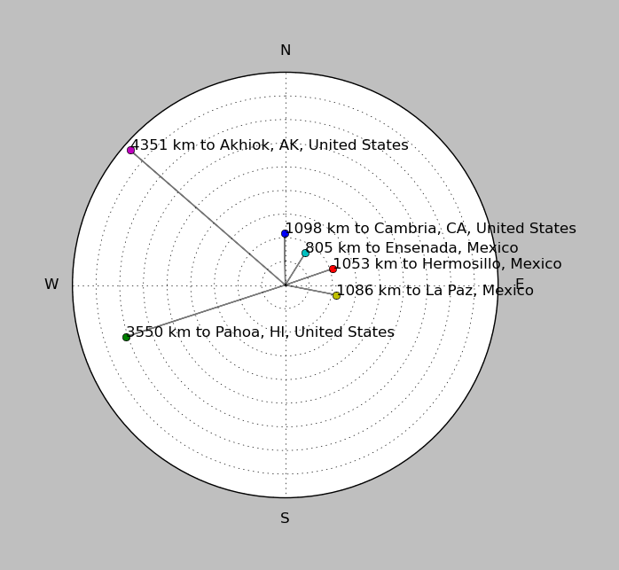
| ||||||||||||||||
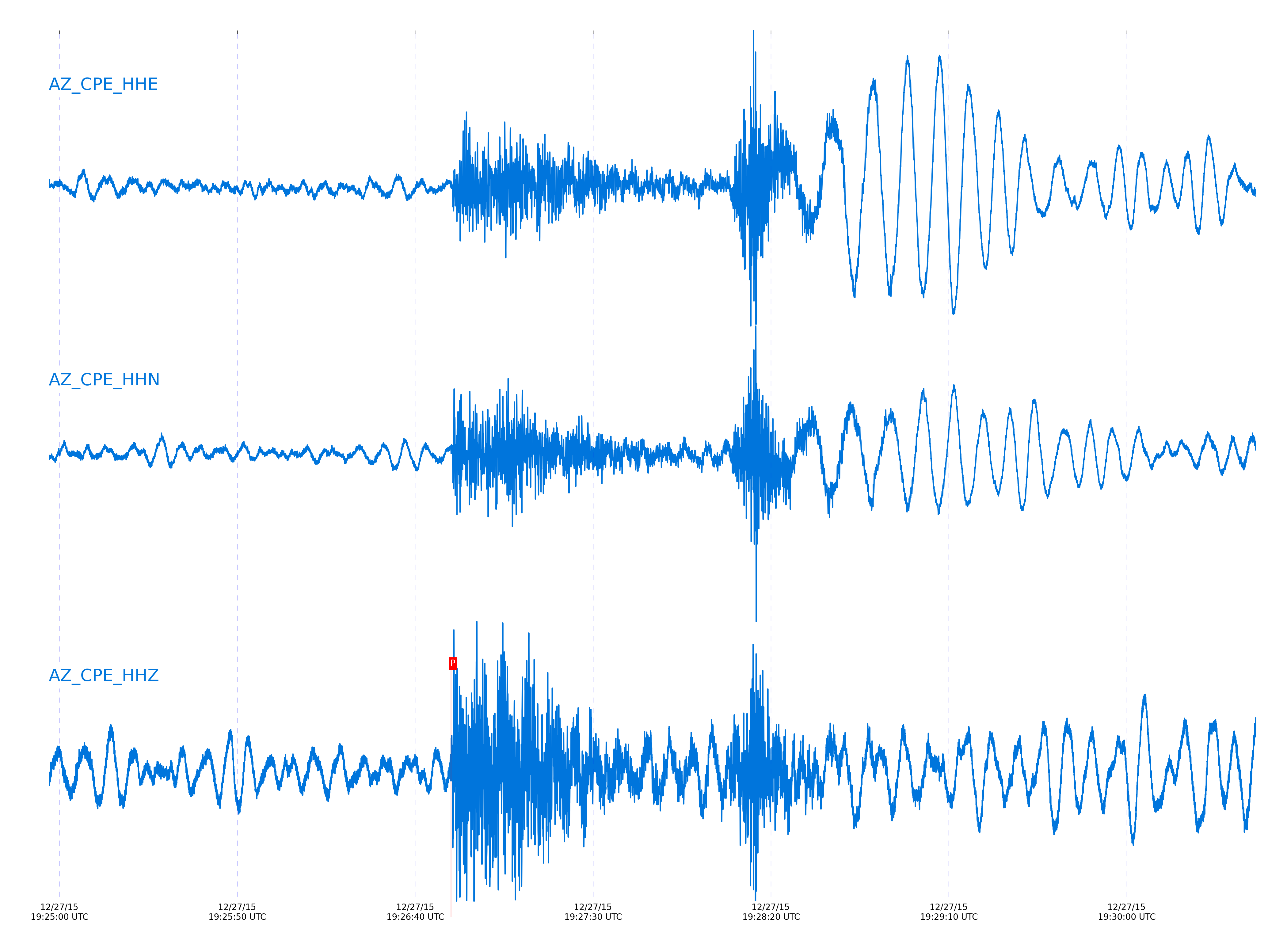
Event and active stations
|
|||||||||||||||||
Closest station with identified signal. Not filtered.
Subset of several stations close to the event. Not filtered.
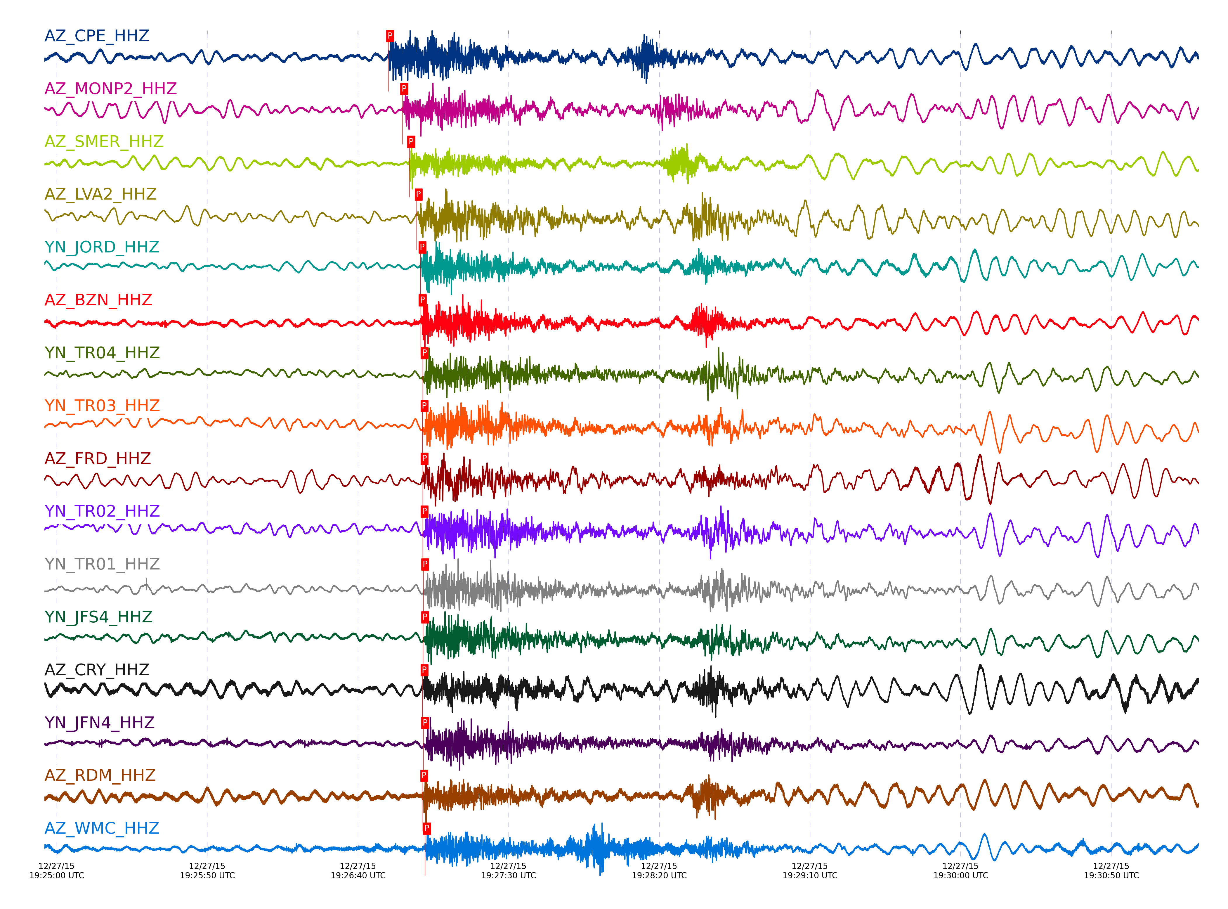
| STA_CHAN | S-E Delta | S-E Azimuth | Phase | Time | Signal/Noise | Time Residual | V. Model | Auth | arid |
|---|---|---|---|---|---|---|---|---|---|
| CPE_HHZ | 7.931° | 205.83° | Pn | 2015-12-27 19:26:50.0202 UTC | 19.799 | -2.073 | iasp91 | dbp:jtytell:153 | 806551 |
| MONP2_HHZ | 8.201° | 209.77° | Pn | 2015-12-27 19:26:54.7102 UTC | 19.719 | -1.091 | iasp91 | dbp:jtytell:153 | 806552 |
| SMER_HHZ | 8.424° | 203.79° | Pn | 2015-12-27 19:26:57.0475 UTC | 25.025 | -1.813 | iasp91 | dbp:jtytell:153 | 806553 |
| LVA2_HHZ | 8.549° | 207.5° | Pn | 2015-12-27 19:26:59.4856 UTC | 46.96 | -1.083 | iasp91 | dbp:jtytell:153 | 806554 |
| JORD_HHZ | 8.624° | 206.68° | Pn | 2015-12-27 19:27:00.7395 UTC | 51.638 | -0.866 | iasp91 | dbp:jtytell:153 | 806556 |
| BZN_HHZ | 8.634° | 206.51° | Pn | 2015-12-27 19:27:00.8198 UTC | 19.612 | -0.91 | iasp91 | dbp:jtytell:153 | 806557 |
| TR04_HHZ | 8.643° | 208.09° | Pn | 2015-12-27 19:27:01.4575 UTC | -1 | -0.408 | iasp91 | dbp:jtytell:153 | 806563 |
| TR03_HHZ | 8.654° | 208.08° | Pn | 2015-12-27 19:27:01.4158 UTC | -1 | -0.593 | iasp91 | dbp:jtytell:153 | 806561 |
| FRD_HHZ | 8.661° | 206.85° | Pn | 2015-12-27 19:27:01.4649 UTC | 72.367 | -0.637 | iasp91 | dbp:jtytell:153 | 806564 |
| TR02_HHZ | 8.664° | 208.08° | Pn | 2015-12-27 19:27:01.4809 UTC | -1 | -0.67 | iasp91 | dbp:jtytell:153 | 806565 |
| TR01_HHZ | 8.67° | 208.09° | Pn | 2015-12-27 19:27:01.6526 UTC | 78.686 | -0.572 | iasp91 | dbp:jtytell:153 | 806568 |
| JFS4_HHZ | 8.673° | 208.14° | Pn | 2015-12-27 19:27:01.6431 UTC | -1 | -0.626 | iasp91 | dbp:jtytell:153 | 806567 |
| CRY_HHZ | 8.674° | 205.91° | Pn | 2015-12-27 19:27:01.4507 UTC | 13.4 | -0.834 | iasp91 | dbp:jtytell:153 | 806562 |
| JFN4_HHZ | 8.676° | 208.15° | Pn | 2015-12-27 19:27:01.6974 UTC | -1 | -0.615 | iasp91 | dbp:jtytell:153 | 806569 |
| RDM_HHZ | 8.693° | 205.12° | Pn | 2015-12-27 19:27:01.3242 UTC | 10.393 | -1.216 | iasp91 | dbp:jtytell:153 | 806560 |
| WMC_HHZ | 8.704° | 206.22° | Pn | 2015-12-27 19:27:02.2702 UTC | 15.238 | -0.429 | iasp91 | dbp:jtytell:153 | 806577 |
| SND_HHZ | 8.708° | 206.62° | Pn | 2015-12-27 19:27:02.5256 UTC | 20.205 | -0.222 | iasp91 | dbp:jtytell:153 | 806579 |
| BCCC_HHZ | 8.721° | 205.28° | Pn | 2015-12-27 19:27:01.7252 UTC | 5.5909 | -1.205 | iasp91 | dbp:jtytell:153 | 806570 |
| TMSP_HHZ | 8.743° | 206.06° | Pn | 2015-12-27 19:27:02.8769 UTC | -1 | -0.353 | iasp91 | dbp:jtytell:153 | 806583 |
| RRSP_HHZ | 8.751° | 205.65° | Pn | 2015-12-27 19:27:02.5581 UTC | -1 | -0.779 | iasp91 | dbp:jtytell:153 | 806580 |
| TRO_HHZ | 8.754° | 207.71° | Pn | 2015-12-27 19:27:03.2969 UTC | 17.091 | -0.08 | iasp91 | dbp:jtytell:153 | 806587 |
| RHIL_HHZ | 8.759° | 205.42° | Pn | 2015-12-27 19:27:02.7571 UTC | -1 | -0.692 | iasp91 | dbp:jtytell:153 | 806581 |
| KNW_HHZ | 8.817° | 205.62° | Pn | 2015-12-27 19:27:03.7846 UTC | 12.343 | -0.462 | iasp91 | dbp:jtytell:153 | 806591 |
| PFO_HHZ | 8.819° | 207.27° | Pn | 2015-12-27 19:27:04.3135 UTC | 10.995 | 0.04 | iasp91 | dbp:jtytell:153 | 806594 |
Click the link below to observe an interactive map of earthquakes recorded by the station deployment:
Broadband Seismic Data Collection Center (ANZA),
Institute of Geophysics & Planetary Physics
Scripps Institution of Oceanography,
University of California San Diego
Copyright © 1989 - 2014. All Rights Reserved.