
last update to page: March 15 2016 23:10:54 (UTC).
SummaryThe red marker denotes the earthquake epicenter. On Wed Dec 30th 2015 01:48:57 (UTC) the seismic network recorded an earthquake (preliminary 4.4 mw) located in Southern California. Seismic region California - Nevada Region. The epicentral distance (i.e. distance separating the location to the epicenter) to the closest station CSLB in the network is 79.2 km. If you felt the quake, the USGS would like to know. Please add your comments to the USGS page "Did you feel it?". |
Details
Proximity to Population Centers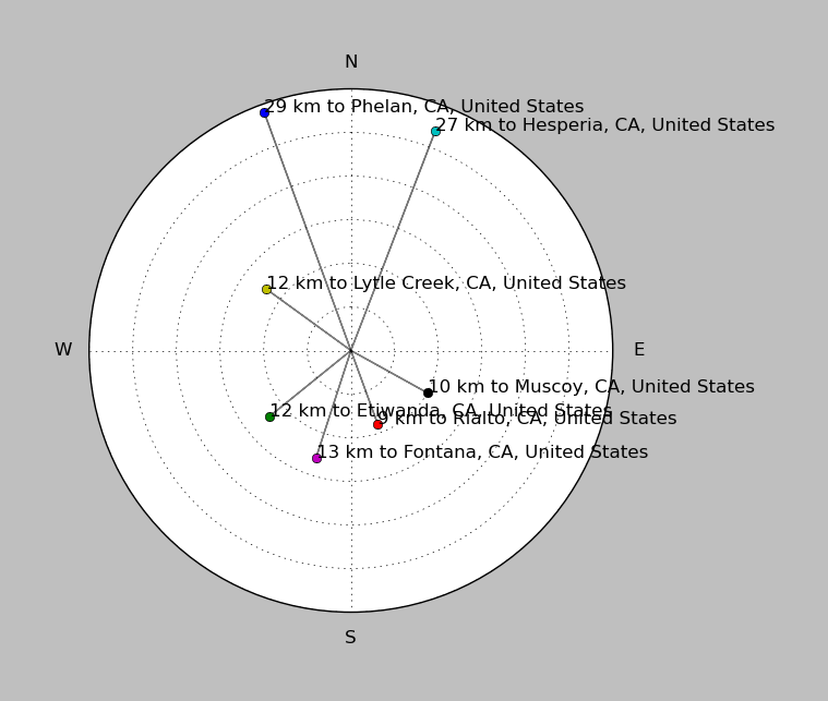
| ||||||||||||||||
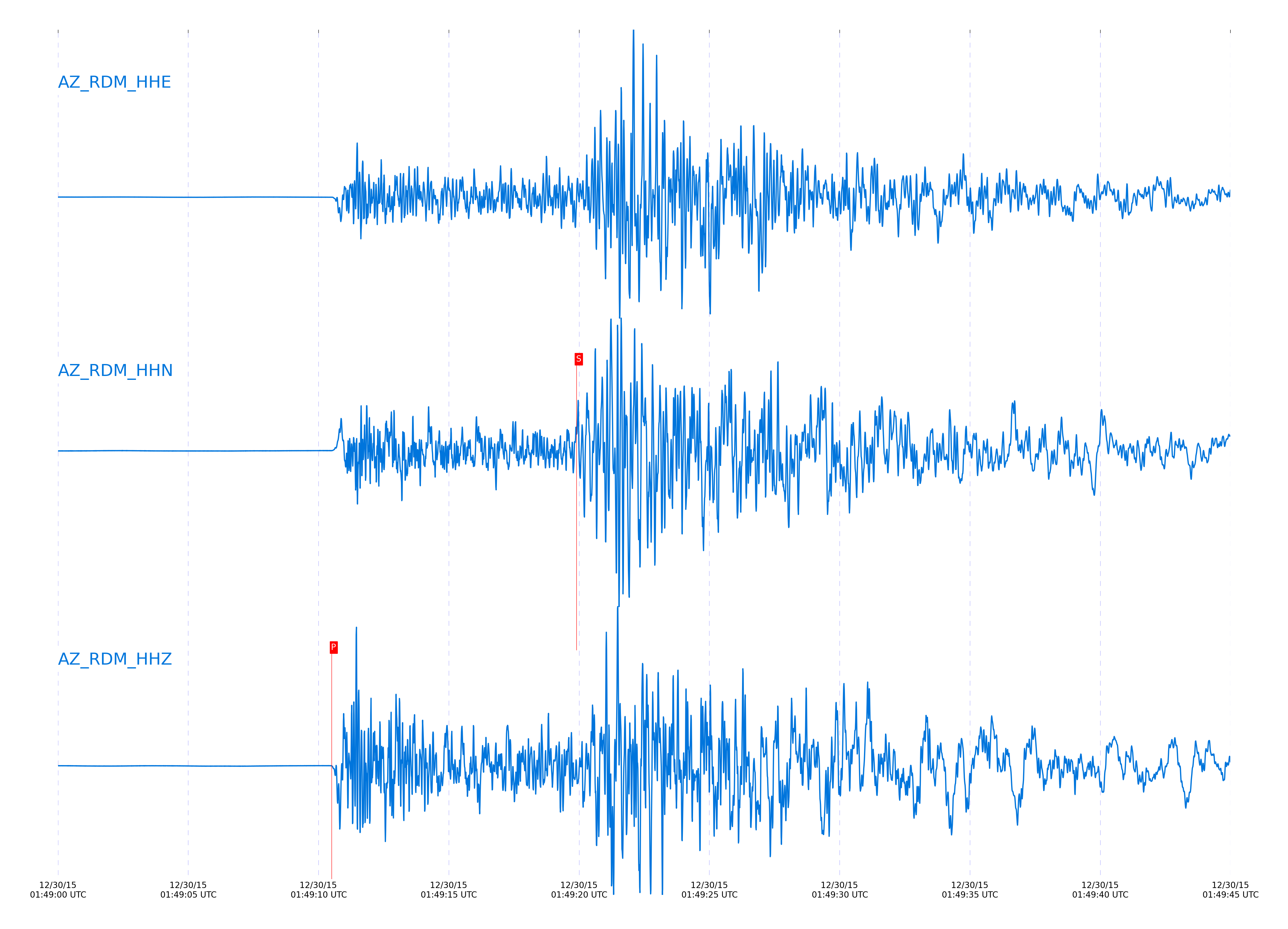
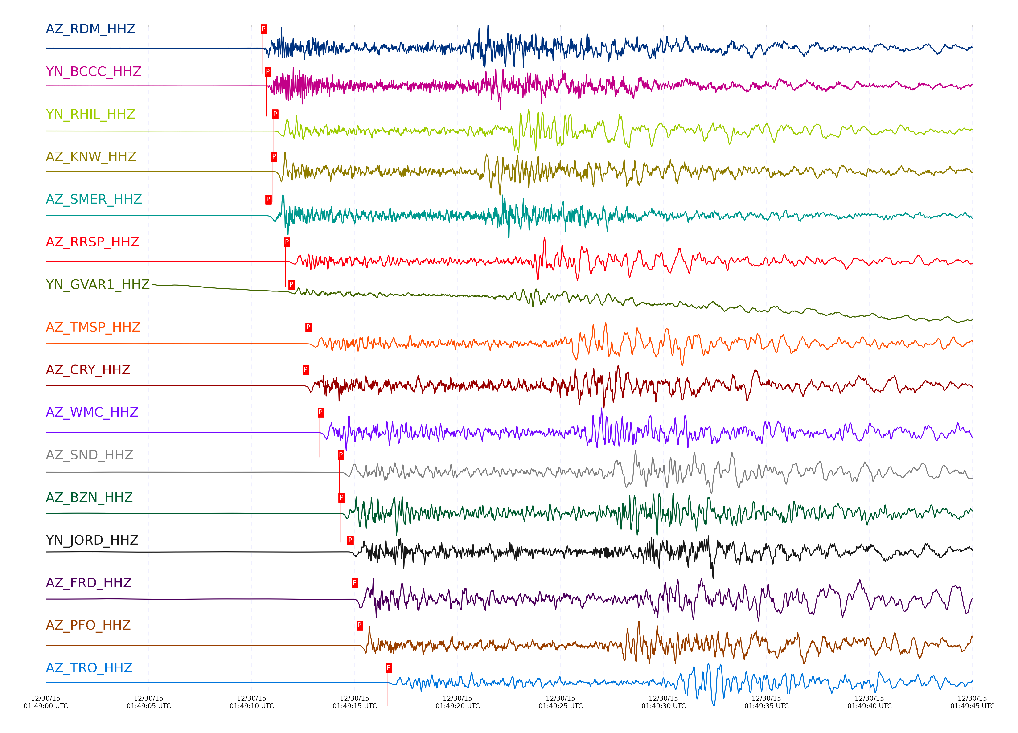
Event and active stations
|
|||||||||||||||||
Closest station with identified signal. Not filtered.
Subset of several stations close to the event. Not filtered.
| STA_CHAN | S-E Delta | S-E Azimuth | Phase | Time | Signal/Noise | Time Residual | V. Model | Auth | arid |
|---|---|---|---|---|---|---|---|---|---|
| RDM_HHZ | 0.73° | 320.34° | Pg | 2015-12-30 01:49:10.5084 UTC | 738.64 | -0.826 | iasp91 | dbp:jtytell:153 | 807486 |
| RDM_HHN | 0.73° | 320.34° | Sg | 2015-12-30 01:49:19.9063 UTC | -1 | -1.613 | iasp91 | dbp:jtytell:153 | 807535 |
| BCCC_HHZ | 0.738° | 317.67° | Pg | 2015-12-30 01:49:10.7082 UTC | -1 | -0.77 | iasp91 | dbp:jtytell:153 | 807487 |
| BCCC_HHE | 0.738° | 317.67° | Sg | 2015-12-30 01:49:20.6007 UTC | -1 | -1.166 | iasp91 | dbp:jtytell:153 | 807537 |
| RHIL_HHZ | 0.741° | 314.45° | Pg | 2015-12-30 01:49:11.0684 UTC | -1 | -0.483 | iasp91 | dbp:jtytell:153 | 807490 |
| RHIL_HHE | 0.741° | 314.45° | Sg | 2015-12-30 01:49:22.2329 UTC | -1 | 0.34 | iasp91 | dbp:jtytell:153 | 807543 |
| KNW_HHN | 0.751° | 309.61° | Sg | 2015-12-30 01:49:20.9874 UTC | -1 | -1.214 | iasp91 | dbp:jtytell:153 | 807538 |
| KNW_HHZ | 0.751° | 309.61° | Pg | 2015-12-30 01:49:11.0198 UTC | 2659.1 | -0.71 | iasp91 | dbp:jtytell:153 | 807489 |
| SMER_HHN | 0.76° | 344.83° | Sg | 2015-12-30 01:49:21.2843 UTC | -1 | -1.214 | iasp91 | dbp:jtytell:153 | 807540 |
| SMER_HHZ | 0.76° | 344.83° | Pg | 2015-12-30 01:49:10.7384 UTC | 1490.9 | -1.164 | iasp91 | dbp:jtytell:153 | 807488 |
| RRSP_HHE | 0.776° | 314.24° | Sg | 2015-12-30 01:49:23.1209 UTC | -1 | 0.1 | iasp91 | dbp:jtytell:153 | 807547 |
| RRSP_HHZ | 0.776° | 314.24° | Pg | 2015-12-30 01:49:11.6458 UTC | -1 | -0.559 | iasp91 | dbp:jtytell:153 | 807492 |
| GVAR1_HHZ | 0.785° | 312.09° | Pg | 2015-12-30 01:49:11.8591 UTC | 87.729 | -0.532 | iasp91 | dbp:jtytell:153 | 807494 |
| GVAR1_HHE | 0.785° | 312.09° | Sg | 2015-12-30 01:49:22.2833 UTC | -1 | -1.06 | iasp91 | dbp:jtytell:153 | 807544 |
| TMSP_HHZ | 0.833° | 313.52° | Pg | 2015-12-30 01:49:12.6828 UTC | -1 | -0.621 | iasp91 | dbp:jtytell:153 | 807498 |
| CRY_HHZ | 0.839° | 318.37° | Pg | 2015-12-30 01:49:12.5484 UTC | 757.46 | -0.871 | iasp91 | dbp:jtytell:153 | 807497 |
| CRY_HHE | 0.839° | 318.37° | Sg | 2015-12-30 01:49:24.5021 UTC | -1 | -0.615 | iasp91 | dbp:jtytell:153 | 807550 |
| WMC_HHN | 0.869° | 315.47° | Sg | 2015-12-30 01:49:25.3495 UTC | -1 | -0.747 | iasp91 | dbp:jtytell:153 | 807553 |
| WMC_HHZ | 0.869° | 315.47° | Pg | 2015-12-30 01:49:13.2784 UTC | 1009.7 | -0.708 | iasp91 | dbp:jtytell:153 | 807501 |
| SND_HHZ | 0.921° | 314.17° | Pg | 2015-12-30 01:49:14.2598 UTC | 1265.5 | -0.718 | iasp91 | dbp:jtytell:153 | 807503 |
| SND_HHE | 0.921° | 314.17° | Sg | 2015-12-30 01:49:27.1785 UTC | -1 | -0.629 | iasp91 | dbp:jtytell:153 | 807557 |
| BZN_HHN | 0.933° | 318.73° | Sg | 2015-12-30 01:49:26.8987 UTC | -1 | -1.329 | iasp91 | dbp:jtytell:153 | 807556 |
| BZN_HHZ | 0.933° | 318.73° | Pg | 2015-12-30 01:49:14.2942 UTC | 2092.9 | -0.927 | iasp91 | dbp:jtytell:153 | 807504 |
| JORD_HHZ | 0.96° | 318.68° | Pg | 2015-12-30 01:49:14.7173 UTC | 1593.4 | -1.013 | iasp91 | dbp:jtytell:153 | 807506 |
| TFRD_HHZ | 0.967° | 316.23° | Pg | 2015-12-30 01:49:15.1026 UTC | -1 | -0.771 | iasp91 | dbp:jtytell:153 | 807510 |
| FRD_HHZ | 0.967° | 316.24° | Pg | 2015-12-30 01:49:14.9272 UTC | 4509 | -0.948 | iasp91 | dbp:jtytell:153 | 807509 |
| FRD_HHE | 0.967° | 316.24° | Sg | 2015-12-30 01:49:28.2239 UTC | -1 | -1.133 | iasp91 | dbp:jtytell:153 | 807565 |
| TFRD_HHN | 0.967° | 316.23° | Sg | 2015-12-30 01:49:28.2366 UTC | -1 | -1.117 | iasp91 | dbp:jtytell:153 | 807566 |
| PFO_HHE | 0.98° | 306.51° | Sg | 2015-12-30 01:49:28.0117 UTC | -1 | -1.742 | iasp91 | dbp:jtytell:153 | 807561 |
| PFO_HHZ | 0.98° | 306.51° | Pg | 2015-12-30 01:49:15.1684 UTC | 549.52 | -0.936 | iasp91 | dbp:jtytell:153 | 807511 |
| TRO_HHE | 1.056° | 309.47° | Sg | 2015-12-30 01:49:30.5619 UTC | -1 | -1.719 | iasp91 | dbp:jtytell:153 | 807574 |
| TRO_HHZ | 1.056° | 309.47° | Pg | 2015-12-30 01:49:16.5878 UTC | 240.74 | -0.981 | iasp91 | dbp:jtytell:153 | 807524 |
| LVA2_HHN | 1.097° | 320.15° | Sg | 2015-12-30 01:49:32.2878 UTC | -1 | -1.343 | iasp91 | dbp:jtytell:153 | 807576 |
| LVA2_HHZ | 1.097° | 320.15° | Pg | 2015-12-30 01:49:17.2131 UTC | 7166.5 | -1.138 | iasp91 | dbp:jtytell:153 | 807527 |
| TR01_HHZ | 1.13° | 313.09° | Pg | 2015-12-30 01:49:17.9285 UTC | 3061.9 | -1.057 | iasp91 | dbp:jtytell:153 | 807530 |
| TR02_HHZ | 1.131° | 313.35° | Pg | 2015-12-30 01:49:17.9142 UTC | -1 | -1.093 | iasp91 | dbp:jtytell:153 | 807528 |
| TR03_HHZ | 1.133° | 313.86° | Pg | 2015-12-30 01:49:17.9749 UTC | -1 | -1.073 | iasp91 | dbp:jtytell:153 | 807531 |
| JFS4_HHZ | 1.136° | 312.83° | Pg | 2015-12-30 01:49:17.9873 UTC | -1 | -1.119 | iasp91 | dbp:jtytell:153 | 807532 |
| JFS4_HHN | 1.136° | 312.83° | Sg | 2015-12-30 01:49:33.3011 UTC | -1 | -1.634 | iasp91 | dbp:jtytell:153 | 807577 |
| JFN4_HHZ | 1.137° | 312.67° | Pg | 2015-12-30 01:49:17.9225 UTC | -1 | -1.188 | iasp91 | dbp:jtytell:153 | 807529 |
| TR04_HHZ | 1.139° | 314.32° | Pg | 2015-12-30 01:49:18.1521 UTC | -1 | -1.008 | iasp91 | dbp:jtytell:153 | 807533 |
| CPE_HHZ | 1.327° | 349° | Pn | 2015-12-30 01:49:20.1 UTC | 273.43 | -2.308 | iasp91 | dbp:jtytell:153 | 807536 |
| CPE_HHE | 1.327° | 349° | Sb | 2015-12-30 01:49:37.8697 UTC | -1 | -3.232 | iasp91 | dbp:jtytell:153 | 807579 |
| SOL_HHZ | 1.357° | 354.29° | Pn | 2015-12-30 01:49:21.1299 UTC | 144.22 | -1.691 | iasp91 | dbp:jtytell:153 | 807539 |
| MONP2_HHZ | 1.538° | 327.87° | Pn | 2015-12-30 01:49:24.4684 UTC | 280.32 | -0.85 | iasp91 | dbp:jtytell:153 | 807549 |
| MONP2_HHE | 1.538° | 327.87° | Sn | 2015-12-30 01:49:44.9115 UTC | -1 | -1.612 | iasp91 | dbp:jtytell:153 | 807580 |
Click the link below to observe an interactive map of earthquakes recorded by the station deployment:
Broadband Seismic Data Collection Center (ANZA),
Institute of Geophysics & Planetary Physics
Scripps Institution of Oceanography,
University of California San Diego
Copyright © 1989 - 2014. All Rights Reserved.