
last update to page: March 15 2016 23:48:43 (UTC).
SummaryThe red marker denotes the earthquake epicenter. On Thu Jan 21st 2016 18:06:59 (UTC) the seismic network recorded an earthquake (preliminary 6.6 mww) located in Off Coast Of Jalisco, Mexico. Seismic region Mexico - Guatemala Area. The epicentral distance (i.e. distance separating the location to the epicenter) to the closest station USGCB in the network is 1,822.8 km. If you felt the quake, the USGS would like to know. Please add your comments to the USGS page "Did you feel it?". |
Details
Proximity to Population Centers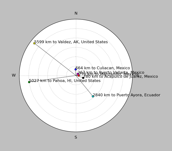
| ||||||||||||||||
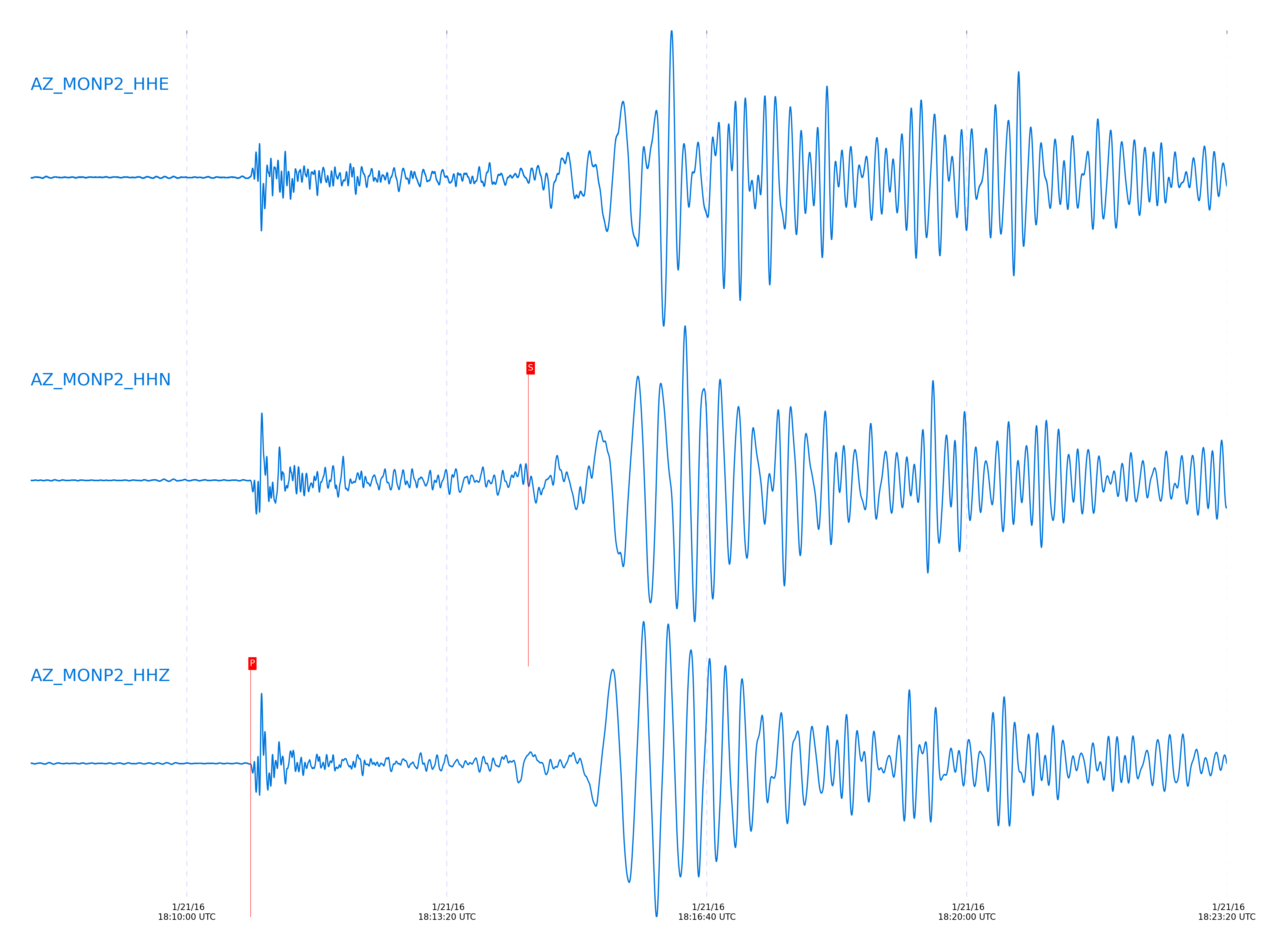
Event and active stations
|
|||||||||||||||||
Closest station with identified signal. Not filtered.
Subset of several stations close to the event. Not filtered.
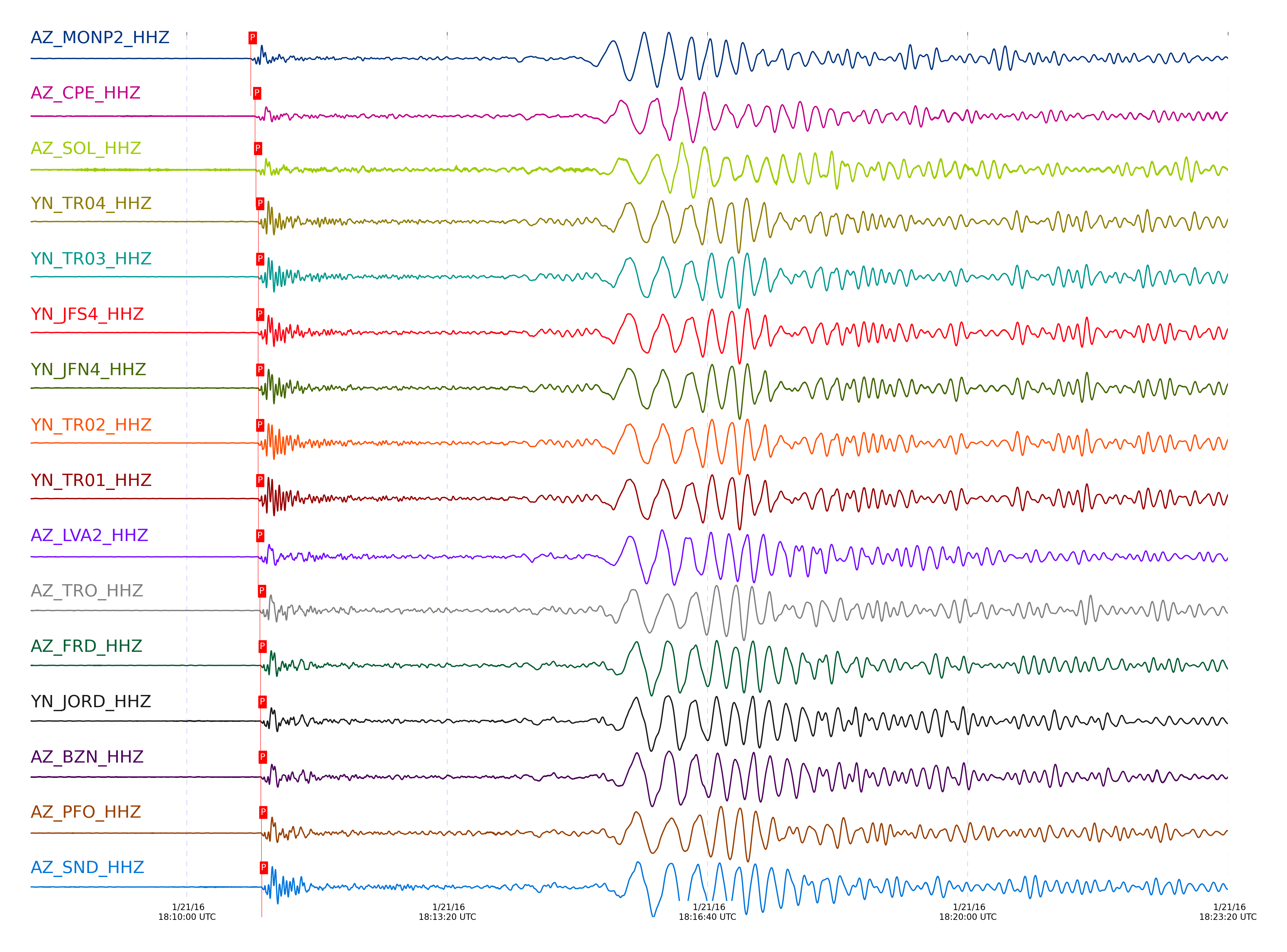
| STA_CHAN | S-E Delta | S-E Azimuth | Phase | Time | Signal/Noise | Time Residual | V. Model | Auth | arid |
|---|---|---|---|---|---|---|---|---|---|
| MONP2_HHZ | 16.412° | 146.56° | Pn | 2016-01-21 18:10:49.0258 UTC | 410.29 | -0.374 | iasp91 | dbp:jtytell:160 | 912239 |
| MONP2_HHN | 16.412° | 146.56° | S | 2016-01-21 18:14:22.7955 UTC | -1 | 18.137 | iasp91 | dbp:jtytell:160 | 912383 |
| CPE_HHZ | 16.734° | 144.6° | Pn | 2016-01-21 18:10:52.386 UTC | 166.59 | -1.095 | iasp91 | dbp:jtytell:160 | 912240 |
| CPE_HHE | 16.734° | 144.6° | S | 2016-01-21 18:14:18.8878 UTC | -1 | 7.648 | iasp91 | dbp:jtytell:160 | 912390 |
| SOL_HHZ | 16.765° | 144.1° | Pn | 2016-01-21 18:10:53.0784 UTC | 55.304 | -0.795 | iasp91 | dbp:jtytell:160 | 912241 |
| SOL_HHN | 16.765° | 144.1° | S | 2016-01-21 18:14:22.5558 UTC | -1 | 10.681 | iasp91 | dbp:jtytell:160 | 912392 |
| TR04_HHZ | 16.839° | 147.47° | Pn | 2016-01-21 18:10:54.8355 UTC | -1 | 0.026 | iasp91 | dbp:jtytell:160 | 912334 |
| TR03_HHZ | 16.847° | 147.5° | Pn | 2016-01-21 18:10:54.8139 UTC | -1 | -0.094 | iasp91 | dbp:jtytell:160 | 912335 |
| JFS4_HHZ | 16.849° | 147.58° | Pn | 2016-01-21 18:10:54.7798 UTC | -1 | -0.154 | iasp91 | dbp:jtytell:160 | 912336 |
| JFN4_HHZ | 16.849° | 147.59° | Pn | 2016-01-21 18:10:54.8681 UTC | -1 | -0.074 | iasp91 | dbp:jtytell:160 | 912337 |
| TR02_HHZ | 16.851° | 147.54° | Pn | 2016-01-21 18:10:54.7106 UTC | -1 | -0.254 | iasp91 | dbp:jtytell:160 | 912338 |
| TR01_HHZ | 16.854° | 147.55° | Pn | 2016-01-21 18:10:54.861 UTC | 645.22 | -0.134 | iasp91 | dbp:jtytell:160 | 912244 |
| LVA2_HHZ | 16.86° | 147° | Pn | 2016-01-21 18:10:54.7867 UTC | 325.98 | -0.294 | iasp91 | dbp:jtytell:160 | 912242 |
| TRO_HHZ | 16.944° | 147.7° | Pn | 2016-01-21 18:10:56.1783 UTC | 592.04 | 0.046 | iasp91 | dbp:jtytell:160 | 912252 |
| TRO_HHE | 16.944° | 147.7° | S | 2016-01-21 18:14:20.9823 UTC | -1 | 5.442 | iasp91 | dbp:jtytell:160 | 912402 |
| FRD_HHZ | 16.999° | 147.14° | Pn | 2016-01-21 18:10:56.6101 UTC | 543.42 | -0.214 | iasp91 | dbp:jtytell:160 | 912254 |
| JORD_HHZ | 17° | 146.98° | Pn | 2016-01-21 18:10:56.5767 UTC | 456.98 | -0.254 | iasp91 | dbp:jtytell:160 | 912256 |
| BZN_HHZ | 17.026° | 146.95° | Pn | 2016-01-21 18:10:56.7853 UTC | 393.27 | -0.374 | iasp91 | dbp:jtytell:160 | 912258 |
| PFO_HHZ | 17.034° | 147.75° | Pn | 2016-01-21 18:10:57.1845 UTC | -1 | -0.074 | iasp91 | dbp:jtytell:160 | 912352 |
| PFO_HHE | 17.034° | 147.75° | S | 2016-01-21 18:14:22.7659 UTC | -1 | 5.394 | iasp91 | dbp:jtytell:160 | 912410 |
| SND_HHZ | 17.052° | 147.21° | Pn | 2016-01-21 18:10:57.5544 UTC | 409.9 | 0.066 | iasp91 | dbp:jtytell:160 | 912261 |
| WMC_HHZ | 17.098° | 147.08° | Pn | 2016-01-21 18:10:58.1334 UTC | 266.46 | 0.066 | iasp91 | dbp:jtytell:160 | 912263 |
| CRY_HHZ | 17.12° | 146.88° | Pn | 2016-01-21 18:10:58.2432 UTC | 224.18 | -0.094 | iasp91 | dbp:jtytell:160 | 912265 |
| TMSP_HHZ | 17.139° | 147.14° | Pn | 2016-01-21 18:10:58.6882 UTC | -1 | 0.106 | iasp91 | dbp:jtytell:160 | 912355 |
| TMSP_HHN | 17.139° | 147.14° | S | 2016-01-21 18:14:34.61 UTC | -1 | -3.507 | iasp91 | dbp:jtytell:160 | 912413 |
| GVAR1_HHZ | 17.19° | 147.15° | Pn | 2016-01-21 18:10:59.1685 UTC | 337.05 | -0.054 | iasp91 | dbp:jtytell:160 | 912266 |
| GVAR1_HHN | 17.19° | 147.15° | S | 2016-01-21 18:14:37.2262 UTC | -1 | -1.748 | iasp91 | dbp:jtytell:160 | 912412 |
| RRSP_HHN | 17.193° | 147.03° | S | 2016-01-21 18:14:35.2746 UTC | -1 | -3.74 | iasp91 | dbp:jtytell:160 | 912414 |
| RRSP_HHZ | 17.193° | 147.03° | Pn | 2016-01-21 18:10:59.1786 UTC | -1 | -0.074 | iasp91 | dbp:jtytell:160 | 912356 |
| BCCC_HHZ | 17.221° | 146.82° | Pn | 2016-01-21 18:10:59.2951 UTC | 100.98 | -0.314 | iasp91 | dbp:jtytell:160 | 912269 |
| BCCC_HHN | 17.221° | 146.82° | S | 2016-01-21 18:14:34.9638 UTC | -1 | -4.529 | iasp91 | dbp:jtytell:160 | 912415 |
| RDM_HHZ | 17.224° | 146.69° | Pn | 2016-01-21 18:10:59.2901 UTC | 289.68 | -0.354 | iasp91 | dbp:jtytell:160 | 912267 |
| RHIL_HHZ | 17.225° | 146.98° | Pn | 2016-01-21 18:10:59.6069 UTC | -1 | -0.054 | iasp91 | dbp:jtytell:160 | 912358 |
| RHIL_HHN | 17.225° | 146.98° | S | 2016-01-21 18:14:35.6799 UTC | -1 | -3.882 | iasp91 | dbp:jtytell:160 | 912417 |
| SMER_HHZ | 17.231° | 145.48° | Pn | 2016-01-21 18:10:59.0401 UTC | 352.73 | -0.695 | iasp91 | dbp:jtytell:160 | 912264 |
| SMER_HHE | 17.231° | 145.48° | S | 2016-01-21 18:14:38.3368 UTC | -1 | -1.324 | iasp91 | dbp:jtytell:160 | 912416 |
| KNW_HHZ | 17.233° | 147.22° | Pn | 2016-01-21 18:10:59.4804 UTC | 367.19 | -0.274 | iasp91 | dbp:jtytell:160 | 912268 |
Click the link below to observe an interactive map of earthquakes recorded by the station deployment:
Broadband Seismic Data Collection Center (ANZA),
Institute of Geophysics & Planetary Physics
Scripps Institution of Oceanography,
University of California San Diego
Copyright © 1989 - 2014. All Rights Reserved.