
last update to page: March 31 2016 18:59:37 (UTC).
SummaryThe red marker denotes the earthquake epicenter. On Sat Feb 20th 2016 06:13:20 (UTC) the seismic network recorded an earthquake (preliminary 4.3 mw) located in Southern California. Seismic region California - Nevada Region. The epicentral distance (i.e. distance separating the location to the epicenter) to the closest station WRDG in the network is 98.1 km. If you felt the quake, the USGS would like to know. Please add your comments to the USGS page "Did you feel it?". |
Details
Proximity to Population Centers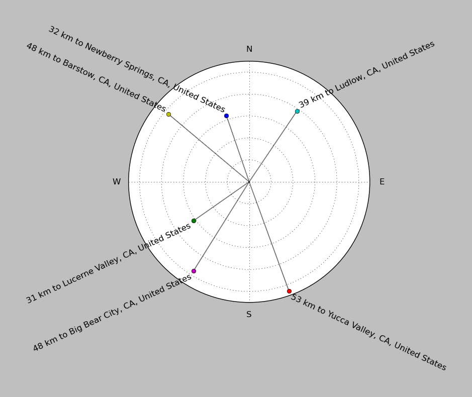
| ||||||||||||||||
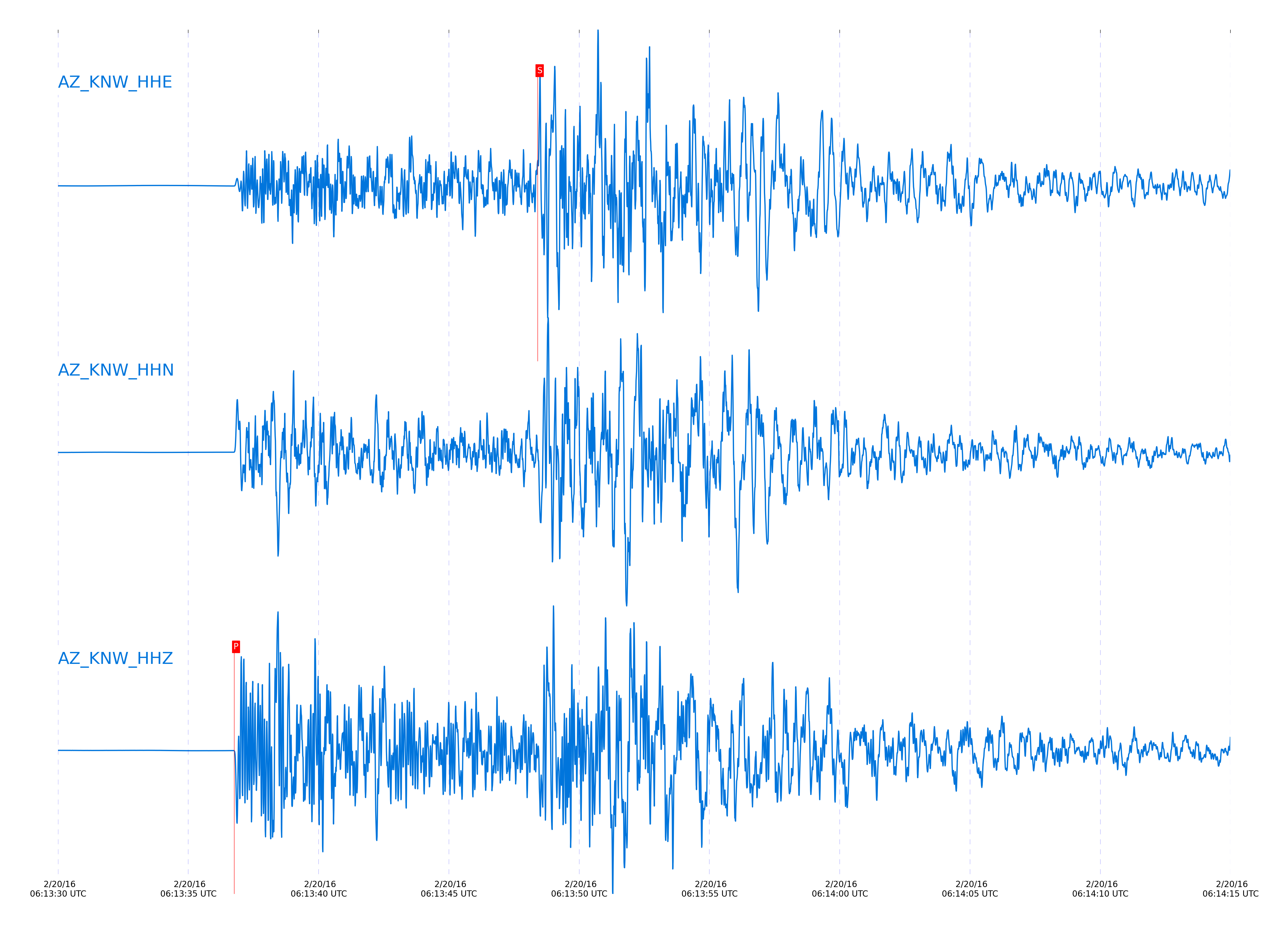
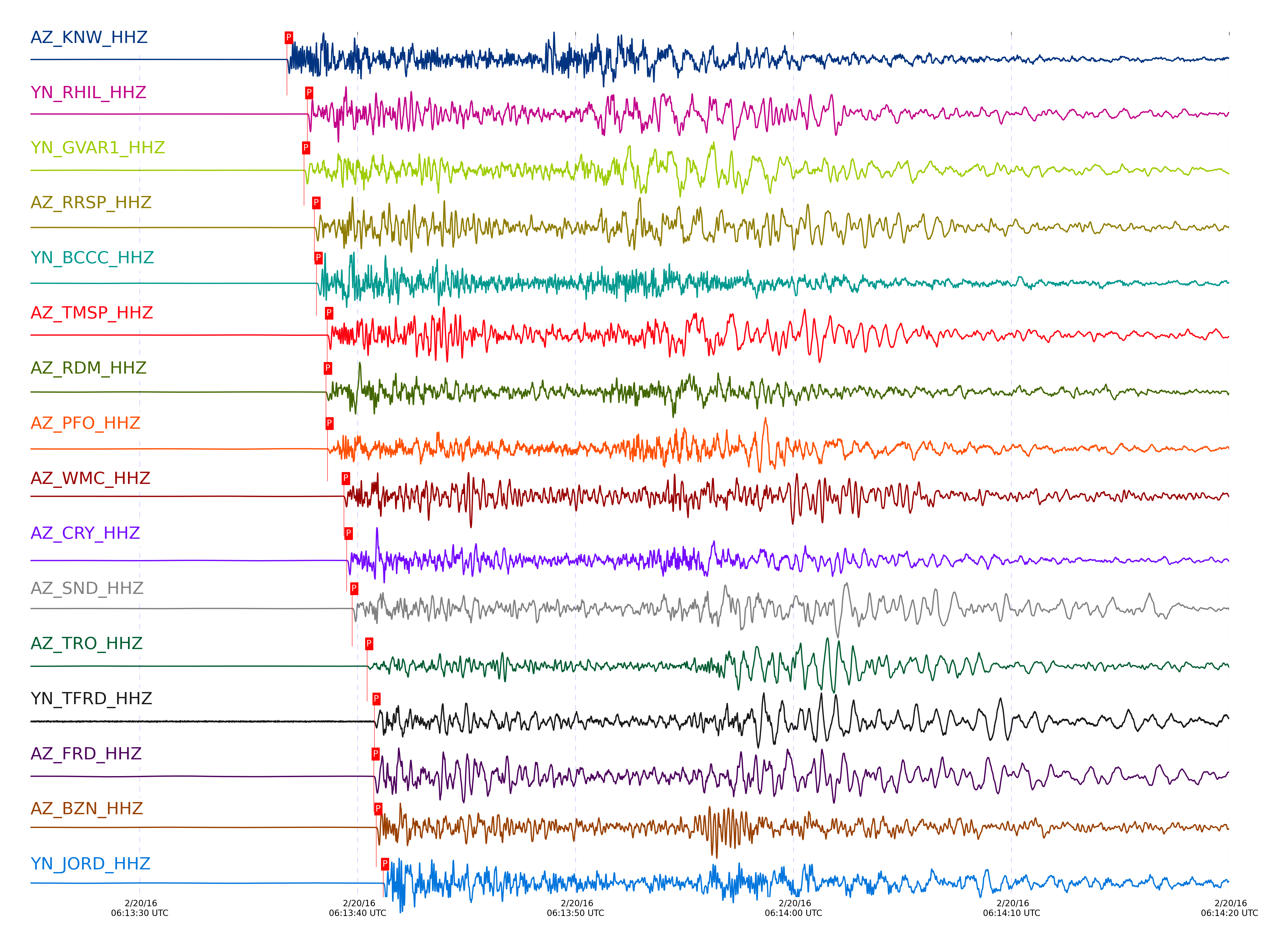
Event and active stations
|
|||||||||||||||||
Closest station with identified signal. Not filtered.
Subset of several stations close to the event. Not filtered.
| STA_CHAN | S-E Delta | S-E Azimuth | Phase | Time | Signal/Noise | Time Residual | V. Model | Auth | arid |
|---|---|---|---|---|---|---|---|---|---|
| KNW_HHZ | 0.897° | 4.22° | Pg | 2016-02-20 06:13:36.7584 UTC | 4144.4 | -0.527 | iasp91 | dbp:jtytell:160 | 937762 |
| KNW_HHE | 0.897° | 4.22° | Sg | 2016-02-20 06:13:48.4041 UTC | -1 | -1.376 | iasp91 | dbp:jtytell:160 | 938057 |
| RHIL_HHZ | 0.943° | 7° | Pg | 2016-02-20 06:13:37.6909 UTC | -1 | -0.467 | iasp91 | dbp:jtytell:160 | 937991 |
| GVAR1_HHZ | 0.945° | 3.74° | Pg | 2016-02-20 06:13:37.549 UTC | 3571.8 | -0.644 | iasp91 | dbp:jtytell:160 | 937772 |
| RRSP_HHZ | 0.962° | 5.29° | Pg | 2016-02-20 06:13:38.0185 UTC | -1 | -0.499 | iasp91 | dbp:jtytell:160 | 937992 |
| BCCC_HHZ | 0.973° | 8.71° | Pg | 2016-02-20 06:13:38.1187 UTC | 2844.7 | -0.625 | iasp91 | dbp:jtytell:160 | 937794 |
| BCCC_HHN | 0.973° | 8.71° | Sg | 2016-02-20 06:13:51.1409 UTC | -1 | -1.156 | iasp91 | dbp:jtytell:160 | 938061 |
| TMSP_HHZ | 0.991° | 2.34° | Pg | 2016-02-20 06:13:38.6056 UTC | -1 | -0.467 | iasp91 | dbp:jtytell:160 | 937995 |
| RDM_HHE | 0.995° | 10.3° | Sg | 2016-02-20 06:13:51.6842 UTC | -1 | -1.332 | iasp91 | dbp:jtytell:160 | 938063 |
| RDM_HHZ | 0.995° | 10.3° | Pg | 2016-02-20 06:13:38.5484 UTC | 431.25 | -0.612 | iasp91 | dbp:jtytell:160 | 937764 |
| PFO_HHE | 1.007° | 351.91° | Sg | 2016-02-20 06:13:51.4627 UTC | -1 | -1.959 | iasp91 | dbp:jtytell:160 | 938067 |
| PFO_HHZ | 1.007° | 351.91° | Pg | 2016-02-20 06:13:38.6249 UTC | 777.03 | -0.77 | iasp91 | dbp:jtytell:160 | 937765 |
| WMC_HHZ | 1.036° | 1.96° | Pg | 2016-02-20 06:13:39.3728 UTC | 325.72 | -0.57 | iasp91 | dbp:jtytell:160 | 937774 |
| CRY_HHZ | 1.047° | 4.76° | Pg | 2016-02-20 06:13:39.4984 UTC | 4377.6 | -0.659 | iasp91 | dbp:jtytell:160 | 937775 |
| CRY_HHE | 1.047° | 4.76° | Sg | 2016-02-20 06:13:53.1958 UTC | -1 | -1.542 | iasp91 | dbp:jtytell:160 | 938075 |
| SND_HHZ | 1.057° | 359.16° | Pg | 2016-02-20 06:13:39.7555 UTC | 2127.8 | -0.593 | iasp91 | dbp:jtytell:160 | 937776 |
| TRO_HHZ | 1.099° | 351.12° | Pg | 2016-02-20 06:13:40.4408 UTC | 134.15 | -0.707 | iasp91 | dbp:jtytell:160 | 937778 |
| TFRD_HHE | 1.114° | 358.75° | Sg | 2016-02-20 06:13:55.4653 UTC | -1 | -1.496 | iasp91 | dbp:jtytell:160 | 938082 |
| TFRD_HHZ | 1.114° | 358.75° | Pg | 2016-02-20 06:13:40.7779 UTC | -1 | -0.668 | iasp91 | dbp:jtytell:160 | 938016 |
| FRD_HHE | 1.115° | 358.75° | Sg | 2016-02-20 06:13:55.2487 UTC | -1 | -1.716 | iasp91 | dbp:jtytell:160 | 938081 |
| FRD_HHZ | 1.115° | 358.75° | Pg | 2016-02-20 06:13:40.7384 UTC | 3847.4 | -0.709 | iasp91 | dbp:jtytell:160 | 937780 |
| BZN_HHZ | 1.118° | 1.49° | Pg | 2016-02-20 06:13:40.8584 UTC | 2296.7 | -0.653 | iasp91 | dbp:jtytell:160 | 937781 |
| JORD_HHZ | 1.137° | 0.55° | Pg | 2016-02-20 06:13:41.1714 UTC | 5282.3 | -0.703 | iasp91 | dbp:jtytell:160 | 937782 |
| JORD_HHE | 1.137° | 0.55° | Sg | 2016-02-20 06:13:55.9832 UTC | -1 | -1.719 | iasp91 | dbp:jtytell:160 | 938083 |
| JFN4_HHZ | 1.2° | 350.89° | Pg | 2016-02-20 06:13:42.0896 UTC | -1 | -0.99 | iasp91 | dbp:jtytell:160 | 938020 |
| TR01_HHZ | 1.2° | 351.39° | Pg | 2016-02-20 06:13:42.2166 UTC | 4560 | -0.865 | iasp91 | dbp:jtytell:160 | 937796 |
| JFS4_HHZ | 1.202° | 351.02° | Pg | 2016-02-20 06:13:42.1573 UTC | -1 | -0.959 | iasp91 | dbp:jtytell:160 | 938021 |
| JFS4_HHN | 1.202° | 351.02° | Sg | 2016-02-20 06:13:58.1541 UTC | -1 | -1.691 | iasp91 | dbp:jtytell:160 | 938084 |
| TR02_HHZ | 1.204° | 351.55° | Pg | 2016-02-20 06:13:42.2448 UTC | -1 | -0.916 | iasp91 | dbp:jtytell:160 | 938022 |
| TR03_HHZ | 1.212° | 351.86° | Pg | 2016-02-20 06:13:42.3652 UTC | -1 | -0.947 | iasp91 | dbp:jtytell:160 | 938023 |
| TR04_HHZ | 1.222° | 352.04° | Pg | 2016-02-20 06:13:42.6173 UTC | -1 | -0.892 | iasp91 | dbp:jtytell:160 | 938024 |
| SMER_HHZ | 1.235° | 21.06° | Pg | 2016-02-20 06:13:42.4335 UTC | 947.78 | -1.321 | iasp91 | dbp:jtytell:160 | 937797 |
| LVA2_HHZ | 1.259° | 357.37° | Pg | 2016-02-20 06:13:43.2631 UTC | 3639 | -0.948 | iasp91 | dbp:jtytell:160 | 937804 |
| MONP2_HHZ | 1.726° | 354.27° | Pn | 2016-02-20 06:13:49.4739 UTC | 216.7 | -1.569 | iasp91 | dbp:jtytell:160 | 937807 |
| CPE_HHZ | 1.765° | 12.76° | Pn | 2016-02-20 06:13:50.1144 UTC | 280.77 | -1.461 | iasp91 | dbp:jtytell:160 | 937812 |
| SOL_HHZ | 1.841° | 16° | Pn | 2016-02-20 06:13:52.7599 UTC | 40.32 | 0.136 | iasp91 | dbp:jtytell:160 | 937841 |
Click the link below to observe an interactive map of earthquakes recorded by the station deployment:
Broadband Seismic Data Collection Center (ANZA),
Institute of Geophysics & Planetary Physics
Scripps Institution of Oceanography,
University of California San Diego
Copyright © 1989 - 2014. All Rights Reserved.