
last update to page: March 31 2016 18:33:41 (UTC).
SummaryThe red marker denotes the earthquake epicenter. On Mon Mar 28th 2016 00:12:54 (UTC) the seismic network recorded an earthquake (preliminary 5.3 mwr) located in Gulf Of California. Seismic region Baja California And Gulf Of California. The epicentral distance (i.e. distance separating the location to the epicenter) to the closest station USGCB in the network is 352.5 km. If you felt the quake, the USGS would like to know. Please add your comments to the USGS page "Did you feel it?". |
Details
Proximity to Population Centers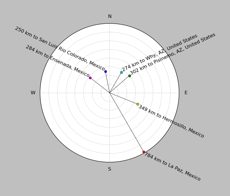
| ||||||||||||||||
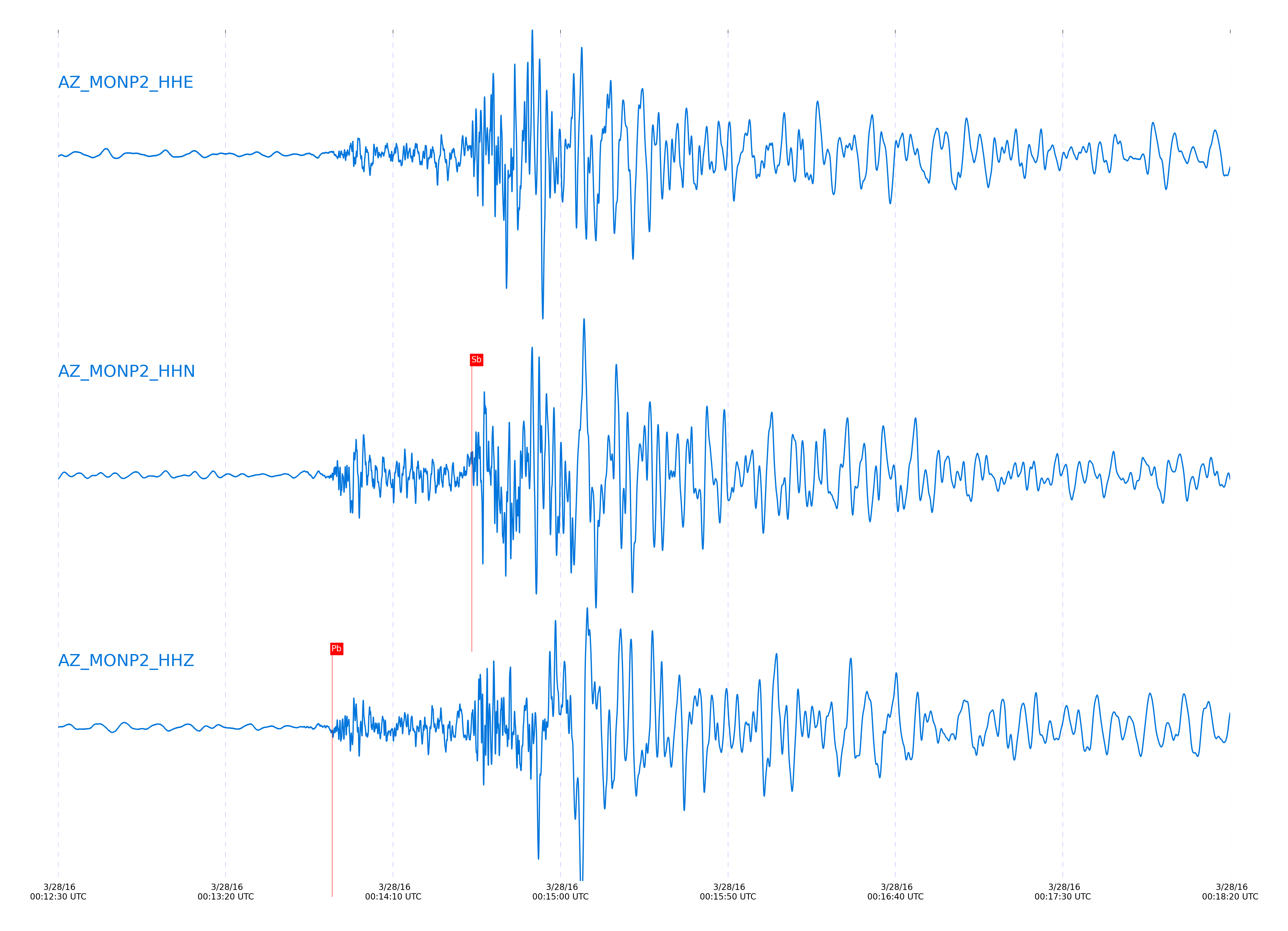
Event and active stations
|
|||||||||||||||||
Closest station with identified signal. Not filtered.
Subset of several stations close to the event. Not filtered.
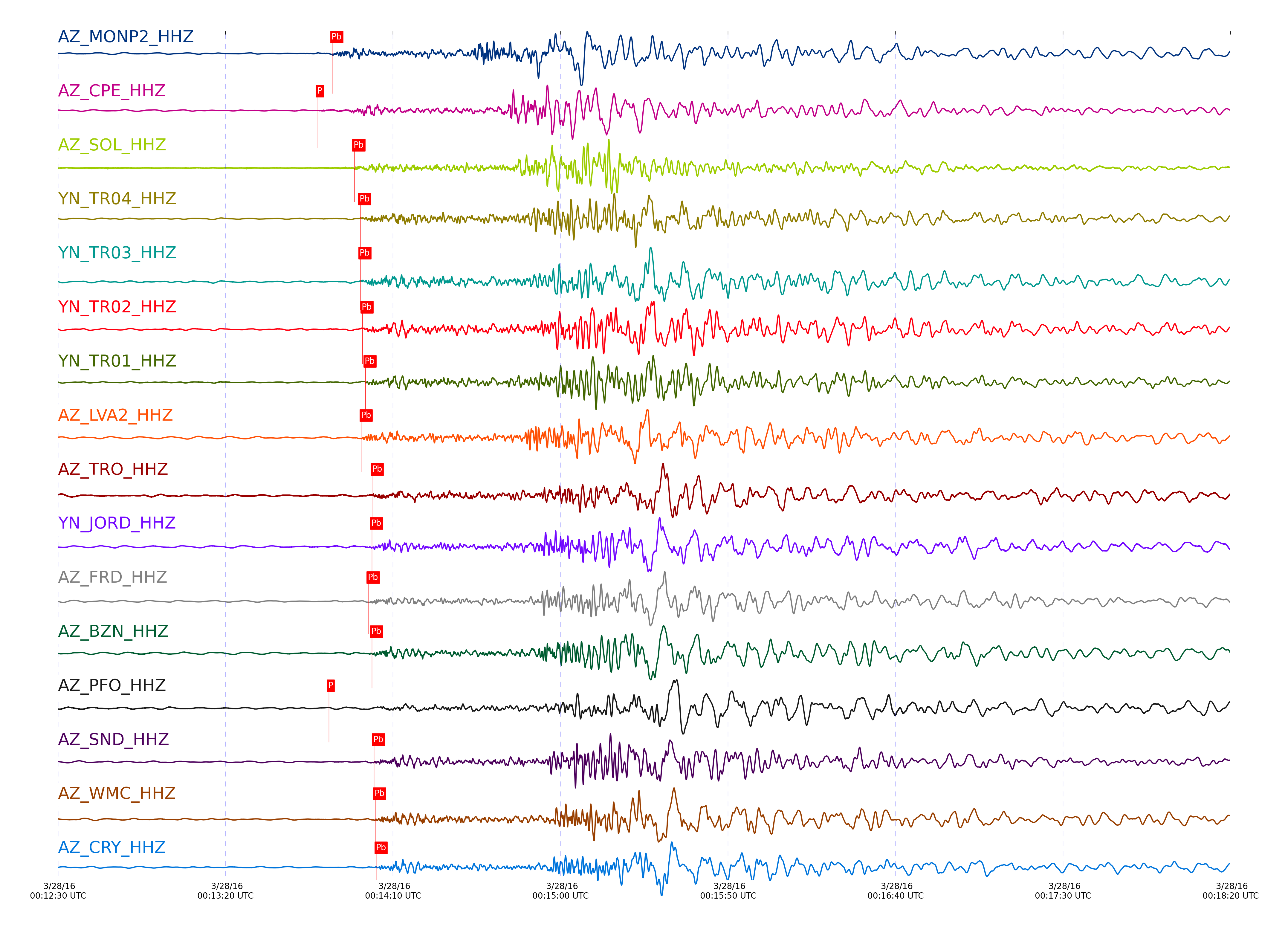
| STA_CHAN | S-E Delta | S-E Azimuth | Phase | Time | Signal/Noise | Time Residual | V. Model | Auth | arid |
|---|---|---|---|---|---|---|---|---|---|
| MONP2_HHZ | 3.198° | 145.35° | Pb | 2016-03-28 00:13:51.8661 UTC | 11.648 | 0.076 | iasp91 | dbp:jtytell:160 | 967513 |
| MONP2_HHN | 3.198° | 145.35° | Sb | 2016-03-28 00:14:33.5347 UTC | -1 | 0.114 | iasp91 | dbp:jtytell:160 | 969873 |
| CPE_HHZ | 3.555° | 137.35° | Pn | 2016-03-28 00:13:47.5604 UTC | 52.915 | -2.553 | iasp91 | dbp:jtytell:160 | 967566 |
| CPE_HHE | 3.555° | 137.35° | Sb | 2016-03-28 00:14:42.2685 UTC | -1 | -1.685 | iasp91 | dbp:jtytell:160 | 969880 |
| SOL_HHZ | 3.603° | 135.36° | PnPn | 2016-03-28 00:13:58.4384 UTC | 65.803 | 0.139 | iasp91 | dbp:jtytell:160 | 967514 |
| TR04_HHZ | 3.628° | 149.86° | pPb | 2016-03-28 00:14:00.2151 UTC | -1 | -0.477 | iasp91 | dbp:jtytell:160 | 969792 |
| TR03_HHZ | 3.636° | 149.98° | pPb | 2016-03-28 00:14:00.2646 UTC | -1 | -0.566 | iasp91 | dbp:jtytell:160 | 969793 |
| JFS4_HHN | 3.639° | 150.31° | Sb | 2016-03-28 00:14:48.4765 UTC | -1 | 2.023 | iasp91 | dbp:jtytell:160 | 969881 |
| TR02_HHZ | 3.641° | 150.12° | pPb | 2016-03-28 00:14:00.8856 UTC | -1 | -0.029 | iasp91 | dbp:jtytell:160 | 969795 |
| TR01_HHZ | 3.644° | 150.2° | PbPb | 2016-03-28 00:14:01.7931 UTC | 55.533 | -0.731 | iasp91 | dbp:jtytell:160 | 967527 |
| LVA2_HHZ | 3.646° | 147.88° | pPb | 2016-03-28 00:14:00.6566 UTC | 9.7878 | -0.344 | iasp91 | dbp:jtytell:160 | 967515 |
| LVA2_HHE | 3.646° | 147.88° | Sb | 2016-03-28 00:14:48.5777 UTC | -1 | 1.919 | iasp91 | dbp:jtytell:160 | 969882 |
| TRO_HHZ | 3.736° | 150.82° | PbPb | 2016-03-28 00:14:03.9515 UTC | 37.563 | -0.15 | iasp91 | dbp:jtytell:160 | 967532 |
| JORD_HHZ | 3.785° | 147.91° | pPb | 2016-03-28 00:14:03.7322 UTC | 77.345 | 0.358 | iasp91 | dbp:jtytell:160 | 967530 |
| JORD_HHE | 3.785° | 147.91° | Sb | 2016-03-28 00:14:52.5263 UTC | -1 | 1.754 | iasp91 | dbp:jtytell:160 | 969884 |
| FRD_HHZ | 3.786° | 148.57° | pPb | 2016-03-28 00:14:02.7324 UTC | 19.195 | -0.647 | iasp91 | dbp:jtytell:160 | 967516 |
| FRD_HHE | 3.786° | 148.57° | Sb | 2016-03-28 00:14:53.5596 UTC | -1 | 2.777 | iasp91 | dbp:jtytell:160 | 969885 |
| BZN_HHE | 3.811° | 147.82° | Sb | 2016-03-28 00:14:54.1788 UTC | -1 | 2.635 | iasp91 | dbp:jtytell:160 | 969887 |
| BZN_HHZ | 3.811° | 147.82° | pPb | 2016-03-28 00:14:03.7435 UTC | 82.211 | -0.075 | iasp91 | dbp:jtytell:160 | 967529 |
| PFO_HHZ | 3.827° | 151.08° | Pn | 2016-03-28 00:13:50.8429 UTC | 22.524 | -3.016 | iasp91 | dbp:jtytell:160 | 967553 |
| PFO_HHE | 3.827° | 151.08° | Sb | 2016-03-28 00:14:54.9644 UTC | -1 | 2.961 | iasp91 | dbp:jtytell:160 | 969892 |
| SND_HHN | 3.839° | 148.9° | Sb | 2016-03-28 00:14:56.3744 UTC | -1 | 4.011 | iasp91 | dbp:jtytell:160 | 969895 |
| SND_HHZ | 3.839° | 148.9° | pPb | 2016-03-28 00:14:04.3335 UTC | 64.262 | 0.041 | iasp91 | dbp:jtytell:160 | 967533 |
| WMC_HHN | 3.884° | 148.38° | Sb | 2016-03-28 00:14:57.7541 UTC | -1 | 4.051 | iasp91 | dbp:jtytell:160 | 969898 |
| WMC_HHZ | 3.884° | 148.38° | pPb | 2016-03-28 00:14:04.6767 UTC | 82.523 | -0.388 | iasp91 | dbp:jtytell:160 | 967535 |
| CRY_HHZ | 3.905° | 147.63° | pPb | 2016-03-28 00:14:05.123 UTC | 140.07 | -0.295 | iasp91 | dbp:jtytell:160 | 967534 |
| CRY_HHE | 3.905° | 147.63° | Sb | 2016-03-28 00:14:56.5145 UTC | -1 | 2.2 | iasp91 | dbp:jtytell:160 | 969897 |
| TMSP_HHZ | 3.926° | 148.66° | pPb | 2016-03-28 00:14:05.7073 UTC | -1 | -0.067 | iasp91 | dbp:jtytell:160 | 969856 |
| GVAR1_HHN | 3.977° | 148.73° | Sb | 2016-03-28 00:14:59.9171 UTC | -1 | 3.468 | iasp91 | dbp:jtytell:160 | 969899 |
| GVAR1_HHZ | 3.977° | 148.73° | pPb | 2016-03-28 00:14:06.0617 UTC | 41.575 | -0.588 | iasp91 | dbp:jtytell:160 | 967556 |
| RRSP_HHZ | 3.979° | 148.27° | pPb | 2016-03-28 00:14:06.3276 UTC | -1 | -0.35 | iasp91 | dbp:jtytell:160 | 969858 |
| RRSP_HHN | 3.979° | 148.27° | Sb | 2016-03-28 00:15:00.8942 UTC | -1 | 4.396 | iasp91 | dbp:jtytell:160 | 969900 |
| BCCC_HHZ | 4.007° | 147.47° | pPb | 2016-03-28 00:14:07.3366 UTC | 96.692 | 0.187 | iasp91 | dbp:jtytell:160 | 967554 |
| BCCC_HHE | 4.007° | 147.47° | Sb | 2016-03-28 00:15:00.3478 UTC | -1 | 3.032 | iasp91 | dbp:jtytell:160 | 969902 |
| RDM_HHE | 4.009° | 146.95° | Sb | 2016-03-28 00:14:59.9467 UTC | -1 | 2.557 | iasp91 | dbp:jtytell:160 | 969903 |
| RDM_HHZ | 4.009° | 146.95° | pPb | 2016-03-28 00:14:07.2663 UTC | 96.008 | 0.074 | iasp91 | dbp:jtytell:160 | 967555 |
| RHIL_HHZ | 4.012° | 148.09° | pPb | 2016-03-28 00:14:07.9996 UTC | -1 | 0.769 | iasp91 | dbp:jtytell:160 | 969861 |
| KNW_HHZ | 4.021° | 149.03° | pPb | 2016-03-28 00:14:06.9977 UTC | 41.871 | -0.388 | iasp91 | dbp:jtytell:160 | 967557 |
| KNW_HHE | 4.021° | 149.03° | Sb | 2016-03-28 00:15:02.541 UTC | -1 | 4.815 | iasp91 | dbp:jtytell:160 | 969905 |
| SMER_HHZ | 4.025° | 142.23° | Pb | 2016-03-28 00:14:05.6593 UTC | 91.649 | -0.225 | iasp91 | dbp:jtytell:160 | 967536 |
| SMER_HHE | 4.025° | 142.23° | Sb | 2016-03-28 00:14:56.4348 UTC | -1 | -1.415 | iasp91 | dbp:jtytell:160 | 969904 |
Click the link below to observe an interactive map of earthquakes recorded by the station deployment:
Broadband Seismic Data Collection Center (ANZA),
Institute of Geophysics & Planetary Physics
Scripps Institution of Oceanography,
University of California San Diego
Copyright © 1989 - 2014. All Rights Reserved.