
last update to page: April 15 2016 16:51:55 (UTC).
SummaryThe red marker denotes the earthquake epicenter. On Fri Apr 15th 2016 14:11:29 (UTC) the seismic network recorded an earthquake (preliminary 6.2 mwp) located in Off Coast Of Chiapas, Mexico. Seismic region Mexico - Guatemala Area. The epicentral distance (i.e. distance separating the location to the epicenter) to the closest station USGCB in the network is 3,258.9 km. If you felt the quake, the USGS would like to know. Please add your comments to the USGS page "Did you feel it?". |
Details
Proximity to Population Centers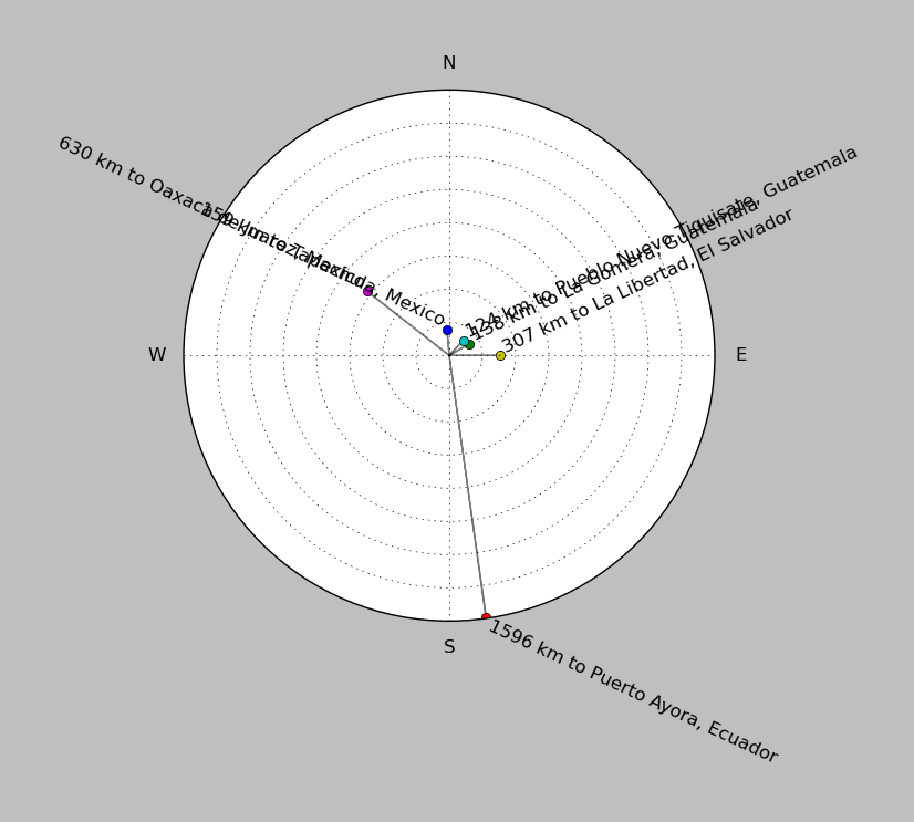
| ||||||||||||||||
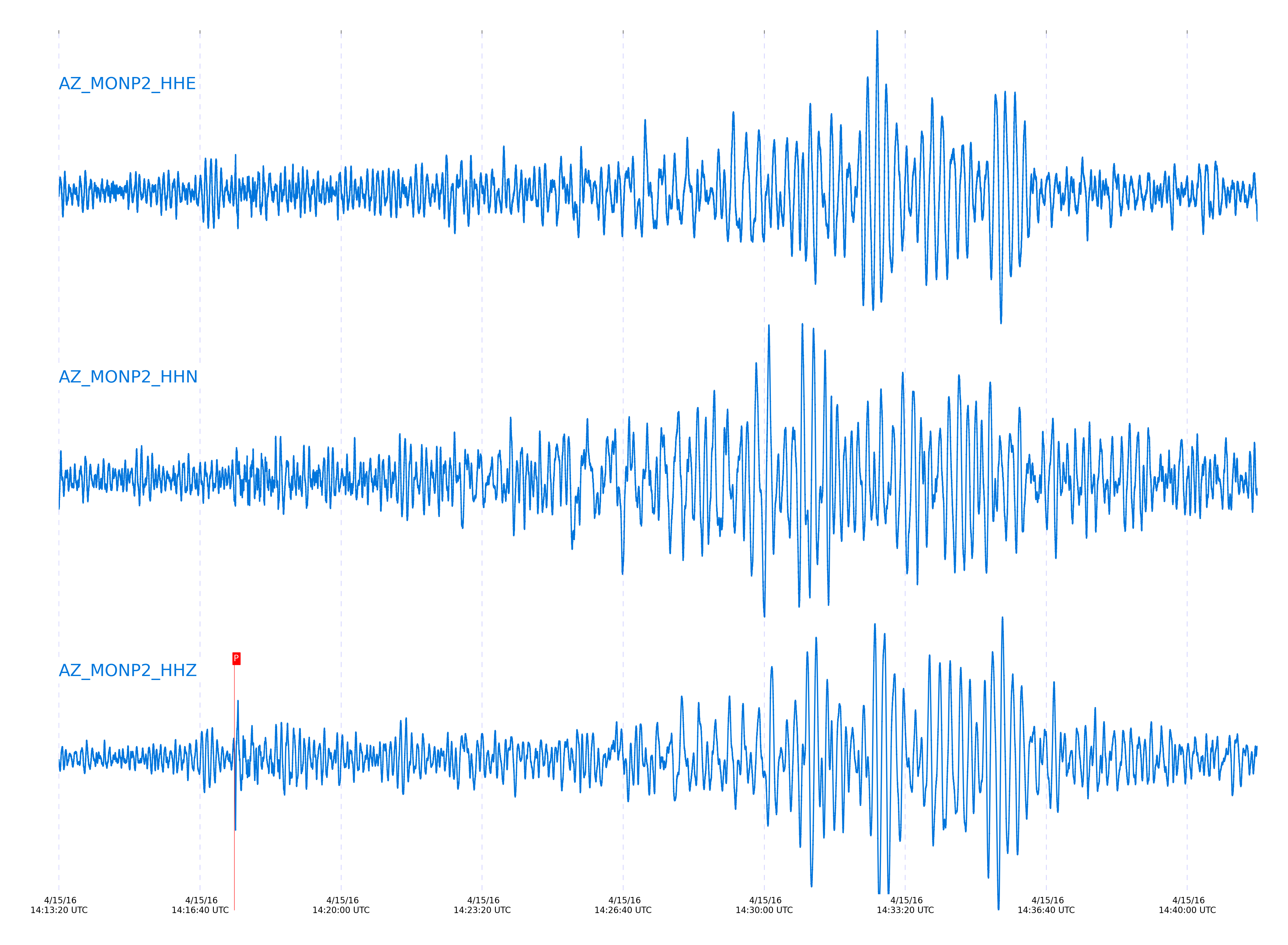
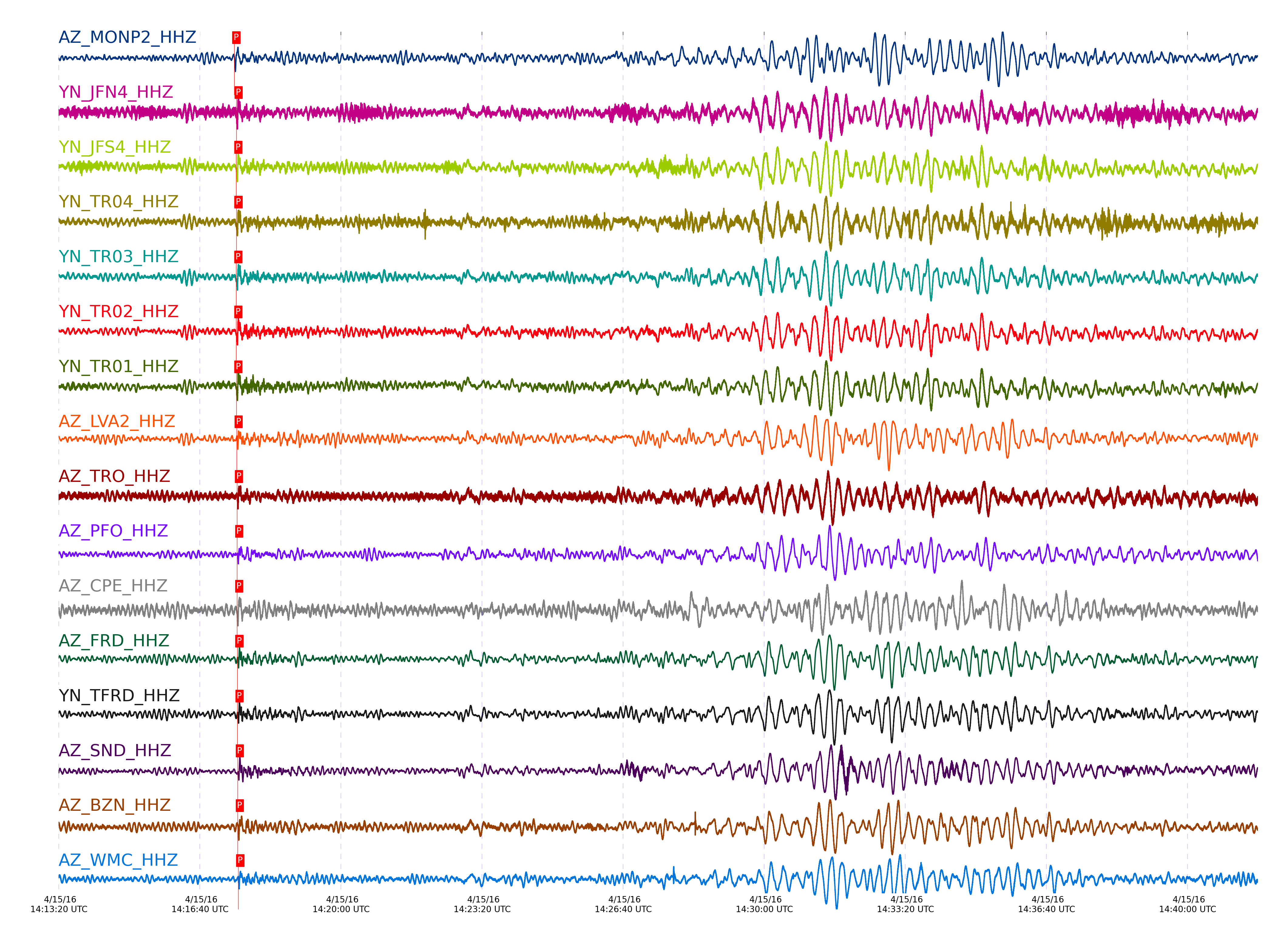
Event and active stations
|
|||||||||||||||||
Closest station with identified signal. Not filtered.
Subset of several stations close to the event. Not filtered.
| STA_CHAN | S-E Delta | S-E Azimuth | Phase | Time | Signal/Noise | Time Residual | V. Model | Auth | arid |
|---|---|---|---|---|---|---|---|---|---|
| MONP2_HHZ | 29.423° | 125.58° | P | 2016-04-15 14:17:28.811 UTC | -1 | -0.029 | iasp91 | dbp:jtytell:161 | 984497 |
| JFN4_HHZ | 29.722° | 126.37° | P | 2016-04-15 14:17:31.8916 UTC | -1 | 0.411 | iasp91 | dbp:jtytell:161 | 984485 |
| JFS4_HHZ | 29.722° | 126.36° | P | 2016-04-15 14:17:31.5689 UTC | -1 | 0.083 | iasp91 | dbp:jtytell:161 | 984484 |
| TR04_HHZ | 29.723° | 126.29° | P | 2016-04-15 14:17:31.8574 UTC | -1 | 0.363 | iasp91 | dbp:jtytell:161 | 984486 |
| TR03_HHZ | 29.728° | 126.31° | P | 2016-04-15 14:17:31.5851 UTC | -1 | 0.051 | iasp91 | dbp:jtytell:161 | 984483 |
| TR02_HHZ | 29.729° | 126.33° | P | 2016-04-15 14:17:31.6482 UTC | -1 | 0.106 | iasp91 | dbp:jtytell:161 | 984482 |
| TR01_HHZ | 29.729° | 126.35° | P | 2016-04-15 14:17:31.7246 UTC | -1 | 0.178 | iasp91 | dbp:jtytell:161 | 984481 |
| LVA2_HHZ | 29.787° | 126.04° | P | 2016-04-15 14:17:32.2069 UTC | -1 | 0.151 | iasp91 | dbp:jtytell:161 | 984480 |
| TRO_HHZ | 29.797° | 126.47° | P | 2016-04-15 14:17:32.555 UTC | -1 | 0.408 | iasp91 | dbp:jtytell:161 | 984477 |
| PFO_HHZ | 29.872° | 126.55° | P | 2016-04-15 14:17:32.8266 UTC | -1 | 0.016 | iasp91 | dbp:jtytell:161 | 984466 |
| CPE_HHZ | 29.891° | 124.62° | P | 2016-04-15 14:17:32.9221 UTC | -1 | -0.053 | iasp91 | dbp:jtytell:161 | 984496 |
| FRD_HHZ | 29.899° | 126.18° | P | 2016-04-15 14:17:33.1614 UTC | -1 | 0.117 | iasp91 | dbp:jtytell:161 | 984459 |
| TFRD_HHZ | 29.899° | 126.18° | P | 2016-04-15 14:17:33.2052 UTC | -1 | 0.16 | iasp91 | dbp:jtytell:161 | 984460 |
| JORD_HHZ | 29.914° | 126.09° | P | 2016-04-15 14:17:33.3574 UTC | -1 | 0.175 | iasp91 | dbp:jtytell:161 | 984457 |
| SND_HHZ | 29.94° | 126.25° | P | 2016-04-15 14:17:33.7363 UTC | -1 | 0.33 | iasp91 | dbp:jtytell:161 | 984453 |
| BZN_HHZ | 29.94° | 126.09° | P | 2016-04-15 14:17:33.6542 UTC | -1 | 0.241 | iasp91 | dbp:jtytell:161 | 984455 |
| WMC_HHZ | 29.994° | 126.19° | P | 2016-04-15 14:17:34.3754 UTC | -1 | 0.488 | iasp91 | dbp:jtytell:161 | 984451 |
| TMSP_HHZ | 30.025° | 126.24° | P | 2016-04-15 14:17:34.7613 UTC | -1 | 0.599 | iasp91 | dbp:jtytell:161 | 984505 |
| CRY_HHZ | 30.031° | 126.09° | P | 2016-04-15 14:17:34.2707 UTC | -1 | 0.054 | iasp91 | dbp:jtytell:161 | 984450 |
| GVAR1_HHZ | 30.07° | 126.27° | P | 2016-04-15 14:17:34.9556 UTC | -1 | 0.395 | iasp91 | dbp:jtytell:161 | 984445 |
| RRSP_HHZ | 30.084° | 126.21° | P | 2016-04-15 14:17:35.2565 UTC | -1 | 0.579 | iasp91 | dbp:jtytell:161 | 984443 |
| KNW_HHZ | 30.102° | 126.33° | P | 2016-04-15 14:17:35.1434 UTC | -1 | 0.302 | iasp91 | dbp:jtytell:161 | 984444 |
| RHIL_HHZ | 30.118° | 126.19° | P | 2016-04-15 14:17:35.7556 UTC | -1 | 0.775 | iasp91 | dbp:jtytell:161 | 984440 |
| RDM_HHZ | 30.144° | 126.03° | P | 2016-04-15 14:17:35.4656 UTC | -1 | 0.256 | iasp91 | dbp:jtytell:161 | 984441 |
| SMER_HHZ | 30.262° | 125.34° | P | 2016-04-15 14:17:35.8126 UTC | -1 | -0.44 | iasp91 | dbp:jtytell:161 | 984474 |
Click the link below to observe an interactive map of earthquakes recorded by the station deployment:
Broadband Seismic Data Collection Center (ANZA),
Institute of Geophysics & Planetary Physics
Scripps Institution of Oceanography,
University of California San Diego
Copyright © 1989 - 2014. All Rights Reserved.