
CURRENT PROJECTS
The following projects are either run solely by the Broadband Seismic Data Collection Center, or in collaboration with other research groups.
Click on a button below to read more about a particular project.
ANZA
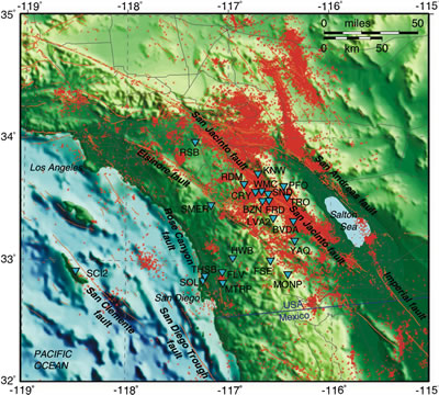
Figure 1: Map of Southern California topography, historical seismicity, and stations in the ANZA network. Stations are centered on the Anza segment of the San Jacinto fault zone.
The ANZA seismic network utilizes state-of-the-art broadband and strong motion sensors with 24-bit dataloggers combined with real-time telemetry to monitor local and regional seismicity in southernmost California and is operated by the University of California at San Diego (UCSD). The goal of this project is to provide on-scale digital recording of high-resolution three-component seismic data for all earthquakes, provide real-time data to the California Integrated Seismic Network (CISN), other regional networks, and the Advanced National Seismic System (ANSS), and provide near real-time information to the greater San Diego community.
The ANZA network has been a leader in developing techniques for real-time data delivery over the Internet. Through the joint efforts of the personnel at the USGS in Pasadena and Caltech, we developed a system in 1995 that sent phase picks and event waveforms to the Southern California Seismic Network (SCSN). By the end of 1996, we had implemented the Object Ring Buffer (ORB) real-time software developed by the University of Colorado supported by funding from IRIS. To effect rapid data transfer to the SCSN, and to its successor TriNet, we installed an ORB server on a computer at Caltech, wrote a software module to interface with the TriNet system, and use this mechanism to routinely transfer all the ANZA data within ten seconds of real-time. In this way, the broadband and strong motion data is seamlessly integrated with the TriNet real-time data processing system. In 2000, a full bi-directional real-time data exchange between ANZA and TriNet was established using the ORB system. Real-time data exchanges between UCSD - UC Berkeley (UCB) and UCSD - University of Nevada-Reno (UNR) have been operational since late 1998.
The ANZA network enhances the broadband coverage provided by the TriNet in southernmost California. ANZA stations are designed to operate in remote areas without any supporting infrastructure such as AC power, telephone or computer communications. Each station can operate using solar power and all communications between stations and the Insitiute of Geophysics and Planetary Physics (IGPP) are dedicated spread spectrum radio links.
The ANZA network is centered on the Anza segment of the San Jacinto fault zone (Figure 1), which has a maximum expected characteristic earthquake magnitude of 7.5 (Working Group, 1995). On 10/31/2001, a M5.1 earthquake occurred in the middle of the ANZA network (8 broadband stations were within 20 km of the epicenter) that spans the San Jacinto fault zone in Southern California. To date the ANZA database contains ~3000 aftershocks of this event, complete to M0.0. Rarely are continuous aftershock data of such high quality available. These data, in combination with an additional ~58,000 events in the Anza region recorded during the past 21 years by the ANZA seismic network, offer a unique opportunity to study earthquake processes.
There is a high level of microseismicity (Ml < 4.5) in the Anza region. It is also located in a region where there are a large number of significant events. The 1986 North Palm Springs (Mw = 6.2), 1987 Superstition Hills (Mw = 6.5), 1987 Elmore Ranch (Mw = 5.9), 1992 Joshua Tree (Mw = 6.1), 1992 Landers (Mw = 7.3), 1992 Big Bear (Mw = 6.2), 1999 Hector Mine (Mw = 7.1) have all occurred within 100 km of the center of the ANZA network since it was installed in 1982. In addition, the Southern California batholith is widely exposed on both sides of the San Jacinto fault near Anza and provides for exceptionally low-loss and homogeneous transmission paths, and consequently high accuracy in determining locations and source parameters (Scott, 1992).
ANF
The Array Network Facility (ANF) for the Earthscope USArray Transportable Array seismic network is responsible for: the delivery of all Transportable Array stations (400 at full deployment) and telemetered Flexible Array stations (up to 200) to the IRIS Data Management Center; station command and control; verification and distribution of metadata; providing useful remotely accessible world wide web interfaces for personnel at the Array Operations Facility (AOF) to access state of health information; and quality control for all data.
HPWREN
The High Performance Wireless Research and Education Network (HPWREN) team is creating, demonstrating, and evaluating a non-commercial, prototype, high-performance, wide-area, wireless network in San Diego county. The NSF-funded network includes backbone nodes on the UC San Diego campus and a number of "hard to reach" areas in San Diego county. Not only is HPWREN used for network analysis research, but the network also provides high-speed Internet access to field researchers from several disciplines (geophysics, astronomy, ecology) and educational opportunities for rural Native American learning centers and schools.
The UC San Diego interdiscplinary project is led by Hans-Werner Braun, a research scientist at the San Diego Supercomputer Center, and Frank Vernon.
Most of the HPWREN team members are housed at the San Diego Supercomputer Center and the Scripps Institution of Oceanography, both located at the University of California, San Diego.
The HPWREN project is based on work sponsored by the National Science Foundation and its ANIR division under Grant Number ANI-0087344.
Notice: National Science Foundation Cites HPWREN
The Bush Administration proposes to increase spending for the National Science Foundation from $4.8 to $5.0 billion. Biological sciences funding would rise from $508 million to $526 million, computer and information science and engineering funds would increase from $515 million to $527 million, engineering would climb by $15 million to $488 million, geosciences funds would spike upward from $610 million to $691 million, mathematical and physical sciences funds would rise by $20 million to $942 million, and funds for social, behavioral and economic sciences would rise by $30 million to $196 million.
The budget cites a San Diego project as an NSF success story:
In August 2000, the University of California, San Diego received a $2.3 million NSF award to develop a prototype wide-area network for research and education. The High Performance Research and Education Network is overcoming geographical, social and technical barriers to bring high-speed Internet access to the La Jolla and Pala Native American reservations. In remote San Diego County, the network connects the low-lying San Diego coastline with the county's mountainous eastern region, home of the reservations. This network also links the University with the Mount Laguna Observatory, an earthquake-detection site. The network is a prototype that could be useful for geophysicists, astronomers and ecologists, while demonstrating that the same tools can connect under-served educational users at remote locations like the Pala and La Jolla reservations.
KNET
In September of 1991 the 10 station Kyrgyz broadband seismic network (KNET) became operational. In its lifetime under IRIS sponsorship using JSP funding, it survived the economic and political turbulence from the breakup of the former Soviet Union and the formation of the Republic of Kyrgyzstan, as well as the occurrence of the 19 August 1992 magnitude 7.4 Suusamyr earthquake located underneath the network station Almayashu (AML). KNET is a cooperative project sponsored by IRIS and the government of Kyrgyzstan. It is operated by Kyrgyz Institute of Seismology (KIS) and the Institute of High Temperature Physics of the Russian Academy of Sciences (IVTAN). The IRIS participants in this project have included University of California at San Diego, Indiana University, Rennselear Polytechnic Institute, and the University of Colorado. The University of California San Diego last had responsibility for collecting and processing KNET data in 2002.
OSN
The primary goal of the Ocean Seismic Network Pilot Experiment (OSNPE) was to learn how to make reliable broadband seismic measurements in the deep ocean. The experiments have implications not only for extending the Global Seismic Network to the oceans, but also for the development of a capability to carry out PASSCAL-type experiments on the ocean floor.
The OSNPE began in January, 1998 and ended in June, 1998. The site of the experiment was the OSN-1 borehole, located about 225 km southwest of Oahu, Hawaii. At the OSN-1 site, three broadband seismographs were deployed within 300 m of each other. The seismometers were: (i) a Teledyne GeoTech KS54000 deployed in a borehole 240 m beneath the seafloor; (ii) a Guralp CMG-3T deployed on the seafloor; and (iii) a Guralp CMG-3T buried just beneath the seafloor.
We refer to the two seafloor seismographs as BBOBS (BroadBand Ocean Bottom Seismograph), and the borehole seismograph as B3S2 (BroadBand Borehole Seismograph System). Each BBOBS station also carries a long-period pressure sensor. In addition to these three broadband stations, three short-period seismometers were also deployed.
ROADNet
The ROADNet multidisciplinary science and technology team is building upon currently deployed autonomous field sensor systems, including sensors that monitor fire and seismic hazards, changing levels of environmental pollutants, water availability and quality, weather, ocean conditions, soil properties, and the distribution and movement of wildlife. ROADNet scientists are also developing the software tools to make this data available in real-time to a variety of end-users, including researchers, policymakers, natural resource managers, educators and students.