
Magnitude 4.7 quake near Oaxaca, Mexico
Last updated: 2018-03-26 17:50:58 UTC
The Anza group at the University of California San Diego operates a broadband seismograph network consisting of 14 (+ 2) three component broadband seismograph stations centered near Anza, California (see map).
On Thursday, October 24th, 2002 at 07:32 (PDT) we recorded a quake (preliminary ml 4.7) located off the coast of Oaxaca, Mexico.
If you felt the quake, the USGS would like to know. Please add to the USGS "Did you feel it?" page.
View the most recent map of local events near San Diego or a slightly wider regional view of events recoded by ANZA, or a map of events recoded by ANZA from around the globe.
Initial source parameters for the recent event and aftershocks are shown below. The epicentral distance (distance separating the epicenter and the closest station in the recording network) for Anza is 26.4 degrees (˜3000 km).
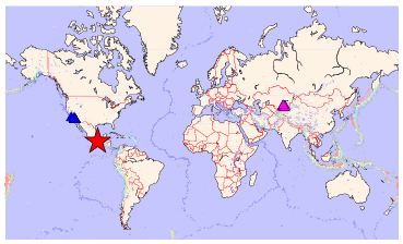
This map shows the mainshock (red star). Anza network stations are blue triangles.
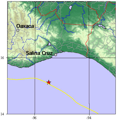
The map below shows the location in more detail, with the Mexico topography, coastline, cities, rivers, lakes and boundaries shown. The plate boundary is in yellow.
| Latitude | Longitude | Origin time (UTC) | Origin time (PST) | Depth | ml | Author |
|---|---|---|---|---|---|---|
| 15.13 | -95.49 | 10/24/02 (297) 00:32:20 | 07:32 (PDT) | 33 | 4.7* | USGS: NEIC |
* The location and magnitude determined for this event are preliminary and are subject to change upon further review of seismic data.
Visit the USGS website with additional links to seismic data for this event.
Learn more about the Anza group (including who works here, other networks, nuclear tests in China/India/Pakistan).
Learn more about the ANZA network (includes more station information, research, etc).
URL: http://eqinfo.ucsd.edu/special_events/2002/297/b/index.php [Last updated: 2018-03-26 17:50:58 UTC]